July 6, 2026
The Tectonic Machinery Behind One of North America's Most Watched Geological Boundaries
Few places on Earth compress hundreds of millions of years of crustal history into a single field of view the way the Alaska Range does. The Denali Fault Trans-Alaska Pipeline earthquake offset is one of the most striking examples of where tectonic theory meets applied engineering. Where the Denali Fault slices through the landscape, the boundary between ancestral North American crust and exotic oceanic terranes is not an abstract geological concept but a physical seam visible in the rock faces, valley geometries, and offset infrastructure surrounding it.
When big ASX news breaks, our subscribers know first
Why the Denali Fault Is One of Earth's Most Consequential Tectonic Boundaries
The Structural Architecture of Alaska's Most Active Strike-Slip System
The Denali Fault is a right-lateral strike-slip system that extends roughly 2,000 kilometres across Alaska and into the Yukon. Its geometry reflects the progressive lateral transport of crustal blocks along the boundary between two fundamentally different types of lithosphere. On its north side, rocks carry the chemical and geochronological fingerprints of ancient North American crust. On its south side, the geology tells a completely different story.
How the Denali Fault Defines the Boundary Between Ancestral North America and Accreted Terranes
Standing at the fault trace in the Alaska Range, the contrast between the two sides becomes striking when you understand what you are looking at. The north-facing slopes expose schists with a shiny, foliated appearance that are recognised as older North American rocks. These rocks contain detrital zircons with Proterozoic and Paleozoic age signatures, a geochemical fingerprint tying them unmistakably to ancestral North American crust.
Wrangellia and the Exotic Terrane Story: What Collided, When, and Why It Matters
On the south side of the fault, the picture changes entirely. Wrangellia is an oceanic and arc-derived terrane that originated far out in the Pacific and was subsequently transported thousands of kilometres before being sutured onto the edge of North America. It lacks the Precambrian zircon signatures characteristic of stable cratonic crust, a distinction that became one of the primary tools geologists use to separate exotic from indigenous material. Furthermore, understanding these ore deposit types helps contextualise the broader tectonic setting across accreted terranes.
Key Insight: The Denali Fault does not simply divide two rock types. It marks a crustal suture between continent-derived material and oceanic terranes that were carried across vast distances before being welded to North America. The fault's narrow, sinuous geometry produces some of the highest and most linear mountain topography on Earth, a direct consequence of the way lateral fault motion concentrates uplift along a tight corridor rather than distributing it across a broad compressional front.
The concept of accreted terranes, first formally recognised by researchers Peter Coney and David Jones in the 1970s, fundamentally changed how geologists understood the construction of western North America. Their work established that many of the crustal blocks making up Alaska, British Columbia, and the Pacific Coast had no ancient relationship to the North American craton and must have arrived from elsewhere.
How Does a Strike-Slip Fault Actually Move?
Dextral Motion Explained: What Right-Lateral Means in Practice
A right-lateral or dextral strike-slip fault moves horizontally, with each side shifting parallel to the fault trace rather than toward or away from it. The key to understanding the motion is perspective: an observer standing on either block and looking across the fault will see the opposing side displaced to the right. On the Denali Fault, this motion has been accumulating for millions of years, progressively offsetting geological features, drainage systems, and, more recently, human infrastructure.
Direct Answer: In a right-lateral strike-slip system, if you stand on one side of the fault and a friend stands on the other, an earthquake will cause your friend's position to shift to the right relative to yours. Over geological time, this motion has displaced entire crustal terranes laterally along the Denali Fault by significant distances.
Why Strike-Slip Faults Produce Narrow, High Mountain Belts
Unlike broad compressional mountain systems where crustal shortening is distributed across wide zones, strike-slip faults focus deformation along tight, linear corridors. The result is a narrow but exceptionally high mountain belt. The Alaska Range, with Denali at its apex, exemplifies this geometry. By contrast, mountain belts dominated by compressional shortening, such as the Canadian Rockies, tend to be far broader but more distributed in elevation.
Flower Structures and Thrust Faults at the Denali Fault Zone
At depth, and at bends and restraining segments along the fault trace, strike-slip motion generates a characteristic structural pattern known as a flower structure. Thrust faults propagate upward and outward from the central fault zone on both sides, producing the topographic ridges visible from viewpoints along the Alaska Range. These features confirm that even in a predominantly lateral fault system, significant vertical movement and crustal thickening can occur at geometric complexities along the fault. 3D geological modelling has become an increasingly important tool for visualising these complex subsurface structures.
The 2002 Denali Fault Earthquake: North America's Largest Recorded Strike-Slip Rupture
Magnitude 7.9 and Its Place in North American Seismic History
On 3 November 2002, the Denali Fault produced a magnitude 7.9 earthquake, the largest earthquake ever recorded in North America from a dominantly strike-slip fault system. The rupture propagated along the fault for approximately 340 kilometres, with displacement values varying considerably along its length. According to research published on the effect of the Denali Fault rupture, the event provided an extraordinary real-world test of earthquake engineering principles.
| Metric | Value |
|---|---|
| Earthquake Magnitude | 7.9 Mw |
| Fault Type | Dominantly Strike-Slip (Dextral) |
| Horizontal Offset at Pipeline Crossing | ~14 feet (4.3 metres) |
| Vertical Offset at Pipeline Crossing | ~2.5 feet (0.76 metres) |
| Maximum Horizontal Offset (Eastern Rupture) | ~29 feet (8.8 metres) |
| Richardson Highway Offset | ~8.5 feet (2.6 metres) |
| Tok Cut-Off Highway Offset | ~23 feet (7 metres) |
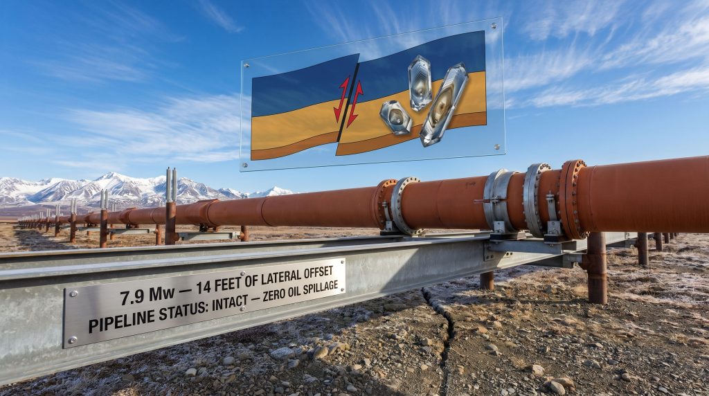
| Pipeline Status Post-Event | Intact, zero oil spillage |
Where the Rupture Was Most Extreme: The Denali-Totschunda Fault Junction
The rupture did not remain on the Denali Fault for its entire length. At its eastern end, it transferred onto the Totschunda Fault, a geometry that contributed to the unusually high maximum displacements recorded there. Near the eastern end of the rupture zone, horizontal offsets approached 29 feet, equivalent to roughly 8.8 metres of lateral ground movement in a matter of seconds.
Infrastructure Damage Inventory: Roads, Landslides, and the Pipeline Comparison
The earthquake offset the Richardson Highway by approximately 8.5 feet and the Tok Cut-Off Highway by approximately 23 feet. Landslides were triggered across the region, and aftershocks continued for weeks. Roads were visibly warped, cracked, and laterally displaced across the fault trace. Yet despite crossing this same fault zone, the Trans-Alaska Pipeline emerged without a single barrel of oil spilled. The contrast between damaged road infrastructure and an intact pipeline was not accidental.
How Was the Trans-Alaska Pipeline Designed to Survive a Major Earthquake?
The Engineering Problem: Routing Steel Pipe Across Active Fault Zones
Before construction began on the Trans-Alaska Pipeline in the early 1970s, extensive geological and geophysical surveys were conducted along the planned route. These surveys identified the Denali Fault as one of the highest-risk crossings along the entire 1,300-kilometre corridor. Design engineers anticipated a maximum credible earthquake of approximately magnitude 8.0 at the fault crossing, a figure remarkably close to what the 2002 event delivered.
The pipeline faces multiple categories of seismic risk along its route:
- Active strike-slip faults capable of large lateral ground displacement
- Dip-slip faults that produce vertical rather than horizontal movement
- Permafrost instability and thaw-related ground deformation
- Seismically triggered landslides and slope failures
The Zigzag Layout and Lateral Sliding System
At the Denali Fault crossing, engineers deliberately introduced a series of directional bends into the pipeline's alignment. This zigzag configuration allows the pipe to flex rather than fracture when the ground beneath it moves laterally. More critically, at the fault crossing itself, the pipeline does not rest on a fixed foundation. Instead, it sits on long horizontal steel beam rails fitted with Teflon-coated sliding shoes.
Engineering Principle: The Teflon shoe and rail system decouples the pipeline from the ground. When fault displacement occurs, the earth moves beneath the pipe while the pipe itself slides freely along the rails, accommodating the offset without accumulating the stresses that would cause rupture. The pipeline is not designed to resist fault movement. It is designed to move with it.
Vertical Fault Crossings: A Different Response for Dip-Slip Zones
Where the pipeline crosses faults that move primarily vertically, a different engineering solution was applied. Rather than horizontal rails, vertical columns were used, and the pipe was configured with sufficient flexibility to accommodate upward or downward movement. This dual-design philosophy, with different engineering responses tailored to different fault kinematics, is one of the reasons the Trans-Alaska Pipeline is cited in engineering geology courses as a landmark case study in applied geoscience.
What Did the 2002 Earthquake Actually Do to the Pipeline?
The 14-Foot Offset and What It Looks Like Today
Before the November 2002 earthquake, the pipeline is understood to have been approximately centred on its horizontal rail system at the fault crossing. Following roughly 14 feet of lateral ground displacement, the pipeline shifted significantly off-centre on those rails. That position has remained unchanged since the earthquake because no comparable rupture has occurred on the Denali Fault Trans-Alaska Pipeline earthquake offset zone since.
The offset is clearly visible today. Looking across the fault trace, the pipeline's trend on one side does not align smoothly with its trend on the other. The dog-leg in the pipe's geometry is a permanent, three-dimensional record of the 2002 rupture, preserved in infrastructure rather than rock. For context, interpreting drill results and surface deformation data from events like this provides invaluable insights into fault behaviour over geological timescales.
The Remaining Rail Capacity and Long-Term Risk
The horizontal rail system at the fault crossing has finite lateral travel capacity. Each large earthquake on the Denali Fault consumes a portion of that available displacement tolerance. This raises a series of important long-term infrastructure management questions:
- How much additional lateral capacity remains on the existing rail system?
- At what point does accumulated offset require engineering intervention, such as rail extension or redesign?
- Could a future rupture comparable to 2002 push the pipeline beyond its designed accommodation range?
These are not hypothetical concerns. The Denali Fault is a geologically active system, and the geological record indicates that large-magnitude ruptures recur on timescales of centuries to millennia. The 2002 event was not the last word.
The next major ASX story will hit our subscribers first
What Can Detrital Zircons Tell Us About Ancient Crustal Boundaries?
Using Zircon Geochronology to Distinguish Crust Types
Detrital zircon analysis has become one of the primary tools for resolving the tectonic history of complex terranes like those found across interior Alaska. The method involves extracting microscopic zircon crystals from sedimentary or metamorphic rocks and measuring their uranium-lead isotopic ratios to determine crystallisation ages. Zircons with Precambrian ages, older than approximately 540 million years, are characteristic of stable cratonic North American crust.
Research conducted at Purdue University, including master's thesis work examining schists from the inboard side of the Denali Fault in the Alaska Range, has identified both Proterozoic and Paleozoic detrital zircon populations in those rocks. This age distribution links them to ancient North American crust, consistent with their interpretation as rocks that once formed part of the continental margin. In addition, geological logging codes play a critical role in standardising how such rock data is recorded and interpreted across complex terrane boundaries.
The Yukon-Tanana Terrane Debate: Rifted Fragment or Intact Continental Margin?
One of the more nuanced debates in Alaskan tectonics concerns the distinction between the classic Yukon-Tanana terrane and what researchers now identify as ancestral North America in parts of interior Alaska.
| Terrane Classification | Key Characteristic | Zircon Signature |
|---|---|---|
| Classic Yukon-Tanana Terrane | Rifted from North America in Late Devonian, re-accreted | Precambrian and Paleozoic |
| Yukon Composite Terrane / Ancestral North America | Remained attached, no rifting record identified | Dominantly Precambrian |
| Wrangellia | Oceanic and arc origin, exotic and transported from Pacific | Lacks North American Precambrian signature |
The critical distinction is whether a block of crust inboard of the Denali Fault actually detached from North America during the Late Devonian opening of the Slide Mountain Ocean and subsequently re-accreted, or whether it remained continuously attached to the continent throughout. Researchers including Cynthia de Spell Bacon and the Yukon Geological Survey have mapped out these differences in detail.
Could More of Interior Alaska Have Been Oceanic? A Competing Hypothesis
The Westward Subduction Model and Precambrian Zircon Contamination
A more radical tectonic hypothesis, associated with researchers including Mitch Mihalynuk and Carl Nelson, proposes that the inboard terranes of interior Alaska were not attached to North America at all. Under this model, even terranes with Precambrian zircon signatures need not represent original North American crust. Instead, the Precambrian zircons could have been shed from the North American margin onto the ocean floor, carried outward on a moving oceanic plate, and incorporated into accreting terranes before eventually arriving at the continent.
Scientific Debate: The contamination hypothesis is intellectually coherent but faces significant evidential challenges. If large volumes of material had been sitting in the ocean and scraped off a descending plate, the geological record should include large accretionary prism structures associated with those inboard terranes. The near-absence of such structures presents a serious difficulty for the fully outboard interpretation.
Why the Absence of Accretionary Prisms Constrains the Model
Accretionary prisms form when material from the downgoing oceanic plate is scraped off and stacked against the overriding plate during subduction. If the inboard terranes of Alaska were all originally outboard, the expectation would be clear physical evidence of these prism structures. Their absence, combined with the lack of North American-signature turbidites in the relevant zones, makes a fully outboard interpretation difficult to sustain without additional evidence. Furthermore, IOCG deposit formation in similar tectonic settings offers comparative insights into how crustal assembly influences mineralisation.
Why the Alaska Range Produces the Highest Topography in North America
The Geometry of Narrow Mountain Belts
The Alaska Range stands apart from other North American mountain systems in its geometry. Where the Canadian Rockies spread across hundreds of kilometres, the Alaska Range is a narrow, sinuous ridge of extreme elevation. Denali, at 6,190 metres, sits within this corridor as the topographic apex of a laterally driven tectonic system.
This geometry is a direct consequence of how strike-slip faulting concentrates deformation. Rather than thickening the crust across a wide front, the Denali Fault system focuses uplift along a linear zone where restraining bends and fault intersections force material upward. The result is mountains that are narrow but extraordinarily high, a pattern with profound consequences for glaciation, erosion rates, and sediment routing into the surrounding lowlands.
Engineering Geology in Practice: What the Pipeline Teaches
The Role of Pre-Construction Geological Surveys
The Trans-Alaska Pipeline represents one of the most consequential early applications of engineering geology to infrastructure planning in North America. The geologic and geophysical surveys conducted before construction not only shaped the pipeline's design but also stimulated broader scientific investigation into Alaska's tectonic history. According to the USGS pipeline overview, the effort to understand fault behaviour and potential magnitudes produced new knowledge that extended well beyond the pipeline corridor itself.
Post-Earthquake GPS Deployment and Mantle Response
Within days of the 2002 earthquake, GPS networks were deployed across the affected region to monitor post-seismic deformation. This data enabled researchers to observe how the mantle responds to the sudden release of crustal stress, a process known as viscoelastic relaxation. By tracking how the surface continues to move in the months and years following a large rupture, scientists can refine models of mantle viscosity and improve seismic hazard assessments for future events.
The fact that GPS monitoring was possible and scientifically productive within 48 hours of the rupture, with researchers in the field measuring aftershock responses in subzero temperatures whilst feeling the ground move beneath them, illustrates how the 2002 event became one of the best-documented large strike-slip earthquakes in history.
Frequently Asked Questions: Denali Fault, the 2002 Earthquake, and the Trans-Alaska Pipeline
What caused the 2002 Denali Fault earthquake?
The 2002 earthquake resulted from accumulated stress along the Denali Fault being released in a sudden rupture. The fault's ongoing right-lateral motion, driven by the relative movement of tectonic plates in the North Pacific region, periodically produces large earthquakes as stress builds beyond the frictional strength of the fault zone.
How much did the ground move during the 2002 earthquake at the pipeline crossing?
At the Trans-Alaska Pipeline crossing, approximately 14 feet (4.3 metres) of horizontal displacement occurred. Further east along the rupture zone, maximum horizontal offsets approached 29 feet (8.8 metres).
Why did the Trans-Alaska Pipeline survive the earthquake intact?
The pipeline's lateral sliding system, consisting of steel beam rails fitted with Teflon shoes, allowed the pipe to move freely as the ground displaced beneath it. The pipeline was not anchored rigidly to the earth at the fault crossing. Instead, it was engineered to accommodate the expected movement range.
What is the Denali Fault and where does it run?
The Denali Fault is a major right-lateral strike-slip fault system extending approximately 2,000 kilometres across southern Alaska and into the Yukon. It runs through the Alaska Range and separates ancestral North American crust from accreted terranes derived from the Pacific realm.
What are accreted terranes and why does the Denali Fault mark their boundary?
Accreted terranes are crustal blocks that originated elsewhere and were transported to and attached onto a continent. The Denali Fault marks the boundary between Wrangellia and other outboard terranes to the south and ancestral North American crust to the north because the fault has served as the primary zone of lateral transport and crustal suturing in this region.
How do engineers design pipelines to cross active fault zones?
Fault zone crossings require engineering solutions tailored to the specific type of fault movement expected. For strike-slip faults, lateral sliding rail systems are used. For dip-slip faults, vertical column systems with flexible pipe configurations are employed. Pre-construction geological surveys identify the fault type, expected displacement magnitude, and crossing geometry, all of which directly shape the engineering response.
What is a right-lateral strike-slip fault?
A right-lateral or dextral strike-slip fault is one where horizontal motion dominates and the block on the opposite side of the fault moves to the right relative to an observer standing on either side. The Denali Fault is one of the largest and most active right-lateral strike-slip systems in North America, and understanding the Denali Fault Trans-Alaska Pipeline earthquake offset demonstrates precisely how such faults behave during major seismic events.
Key Takeaways
- The Denali Fault separates ancestral North American crust from Pacific-derived accreted terranes, making it one of the most significant tectonic boundaries in North America
- The 2002 magnitude 7.9 earthquake produced up to 29 feet of horizontal offset at its maximum, with approximately 14 feet of displacement directly at the Trans-Alaska Pipeline crossing
- The pipeline's survival without oil spillage resulted from a purpose-designed lateral sliding system that accommodated fault displacement rather than resisting it
- The pipeline's current off-centre position on its rail system is a permanent, visible record of the 2002 rupture and a real-time demonstration of strike-slip fault mechanics
- Detrital zircon geochronology, including research conducted through Purdue University, remains a primary tool for distinguishing North American crustal fragments from exotic accreted terranes
- Ongoing scientific debate about whether some inboard Alaskan terranes were originally oceanic highlights how much uncertainty remains in reconstructing the tectonic history of complex continental margins
- The Trans-Alaska Pipeline Denali Fault crossing is widely regarded as a foundational case study in engineering geology, appearing in university-level geology and geotechnical engineering curricula
Further Exploration: Field-based educational content filmed on location in the Alaska Range with tectonic researchers from Purdue University is available on YouTube. This footage offers direct visual access to the fault boundary, the pipeline's engineering design, and the broader tectonic significance of the region in a way that no textbook diagram can fully replicate.
Want to Stay Ahead of the Next Major Mineral Discovery?
Discovery Alert's proprietary Discovery IQ model scans ASX announcements in real time, instantly translating complex geological data across more than 30 commodities into clear, actionable investment insights — the same kind of tectonic-scale opportunity that has historically rewarded early movers. Explore historic discovery returns on Discovery Alert's dedicated discoveries page and begin your 14-day free trial to position yourself ahead of the broader market.