July 3, 2026
The Volcanic Paradox Hidden in Alaska's Eastern Interior
Few geological puzzles are as visually striking as driving through Alaska's Copper River Basin and suddenly confronting a chain of massive, glacier-capped volcanoes rising from a landscape that has no business hosting them. These are not mountains sitting conveniently above a well-defined subducting plate. There is no nearby trench. There is no conventional arc. Yet some of the largest stratovolcanoes on the North American continent stand here, stretching from the Copper River Basin all the way into the Yukon Territory, silently defying the rules that geologists once thought governed where volcanoes could form.
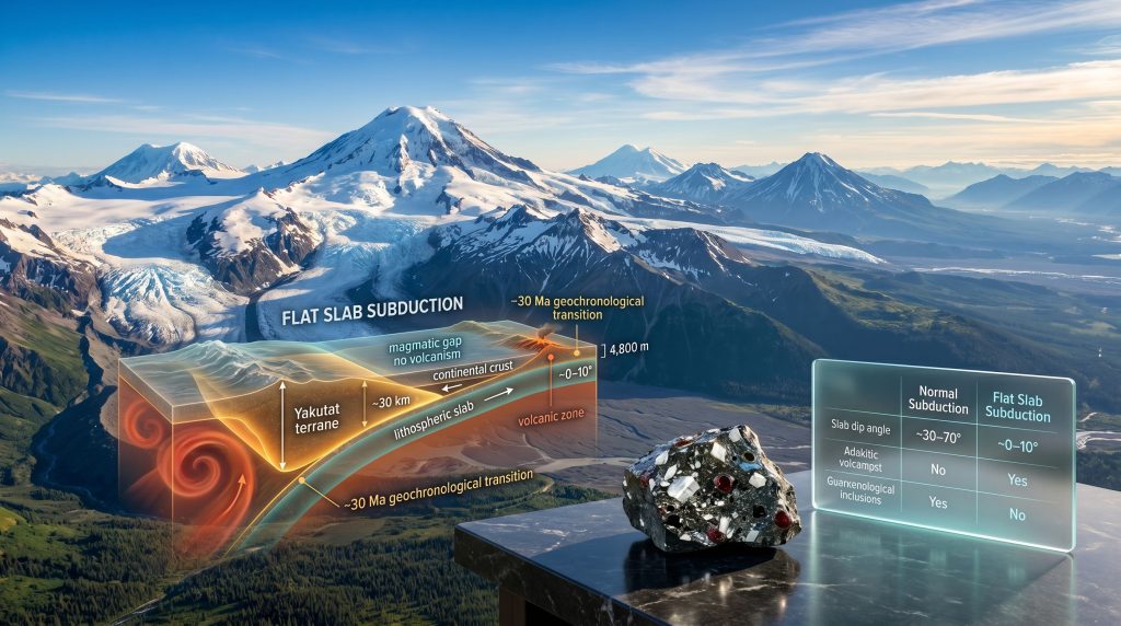
Understanding why the Wrangell volcanoes flat slab subduction in Alaska produces this outcome requires dismantling assumptions about how subduction zones work, and rebuilding them around a far more unusual and geologically instructive phenomenon.
When big ASX news breaks, our subscribers know first
What Standard Subduction Actually Does
To appreciate why the Wrangell field is so anomalous, it helps to understand the baseline model it violates. In a conventional subduction zone, a dense oceanic plate descends steeply into the mantle at angles typically ranging from 30 to 70 degrees. As the slab sinks to depths of roughly 80 to 150 kilometres, elevated pressure and temperature cause it to release water and other volatiles into the overlying mantle wedge.
This fluid infiltration lowers the melting point of the surrounding mantle rock, generating magma that rises to produce a volcanic arc above the descending slab. This process is responsible for the Aleutian arc, the Cascades, and the Andean volcanic belt. The relationship between trench position, slab depth, and arc location is consistent enough that geologists can use arc position to infer subduction geometry, much like reading a map of the global mining landscape reveals where tectonic activity concentrates resources.
The Wrangell field, however, breaks every part of this pattern.
| Feature | Normal Subduction | Flat Slab Subduction |
|---|---|---|
| Slab dip angle | Steep (30–70 degrees) | Shallow (0–10 degrees) |
| Mantle wedge | Present and active | Compressed or absent |
| Arc volcanism | Continuous and predictable | Suppressed or absent |
| Surface topography | Moderate | Extreme uplift inland |
| Sedimentary basin formation | Limited | Pronounced along margins |
The Yakutat Terrane: A Buoyant Intruder
The key to the Wrangell mystery is a fragment of anomalously thick oceanic crust known as the Yakutat microplate. Unlike typical oceanic crust, which averages around seven kilometres in thickness, the Yakutat terrane exceeds 30 kilometres in thickness in places. This excess mass, paradoxically, makes it more buoyant relative to the mantle, not less. Dense, thin oceanic plates sink readily and steeply. Thick, buoyant ones resist descent and tend to slide horizontally beneath the overriding plate instead.
Geophysical imaging confirms that the Yakutat slab extends at an extremely shallow angle, essentially moving horizontally beneath the North American plate for hundreds of kilometres inland. Its leading edge reaches well beneath the continental interior, far past the depth at which a steeply subducting plate would have already triggered arc volcanism. Furthermore, this geometry has three major consequences:
- The mantle wedge between the slab and the overlying crust is effectively eliminated, suppressing conventional arc magmatism.
- The flat slab mechanically couples to the upper plate, transmitting compressional stress hundreds of kilometres inland and driving extreme surface uplift.
- Volcanism migrates from the region above the slab to the lateral edges of the flat slab, where hot asthenospheric mantle can flow around the margins and interact with the slab boundary.
The result is a broad non-magmatic gap directly above the flat slab, flanked by elevated topography and volcanic activity concentrated along its edges, which in Alaska's case are defined by major strike-slip fault systems including the Denali fault, the Totschunda fault, and the Duke River fault.
The 30-Million-Year Switch
One of the most compelling pieces of evidence confirming this tectonic model comes from geochronology. Detailed geochronology of the Wrangell Arc surveys of igneous and plutonic rocks across interior Alaska, including work that systematically excluded airfall volcanic ash deposits that could have travelled from distant sources, reveal a remarkably sharp pattern. In addition, this work draws on broader principles of how supercontinent cycles influence the long-term distribution of subduction activity.
Volcanic and plutonic rocks distributed across the now-inactive arc region all cease at approximately 30 million years ago, representing a geochronological boundary that functions almost like a switch being thrown across an entire geological province.
Before 30 Ma, a conventional volcanic arc was active across the region. After 30 Ma, it switched off entirely. Simultaneously, sedimentary basins along the margins of the flat slab — including the Cook Inlet basin and the Tanana Basin underlying Fairbanks — activated at this same threshold. The Wrangell volcanic field itself initiated at approximately 30 Ma, precisely when the Yakutat terrane's shallow geometry began displacing the previous subduction regime.
This convergence of evidence from igneous geochemistry, sedimentary basin analysis, and thermochronology across multiple research groups has consequently established the flat-slab model as the dominant interpretive framework, even as specific mechanistic details remain actively debated.
How Volcanoes Form at a Slab's Edge
With the flat slab suppressing volcanism across the broad interior region above it, the question becomes how the Wrangell field generates such enormous volcanic output at all. The answer involves several interacting processes.
Edge-Driven Convection
Edge-driven convection is the primary mechanism. Hot asthenospheric mantle, unable to rise directly through the flat slab, flows laterally around the slab's edges. Where this hot mantle contacts the cooler slab margin, decompression melting produces magma that ascends along the structural boundaries defined by major fault systems. This concentrates volcanic output along a relatively narrow corridor rather than distributing it broadly across an arc.
Sediment-Driven Volatile Flux
Sediment-driven volatile flux amplifies the process considerably. The St. Elias and Wrangell mountain ranges host some of the largest glaciers outside the polar regions, producing some of the highest sediment accumulation rates on Earth. This delivers enormous volumes of water-saturated material onto the subducting plate, carrying substantial volatile content that contributes to melt generation at depth.
Adakitic Geochemistry and Inherited Signatures
Adakitic geochemistry provides the chemical fingerprint confirming slab-edge melting is occurring. Several Wrangell volcanoes exhibit adakitic compositions, characterised by elevated strontium-to-yttrium ratios and a strong garnet signature. Adakites form when young, hot oceanic material melts directly rather than simply releasing fluids into the mantle. Their presence is consistent with metamorphism and ore deposits forming under similar high-temperature slab conditions at lateral boundaries.
Some Wrangell volcanoes also display calc-alkaline compositions, which are chemically similar to conventional arc products. Because the lower crust beneath the Wrangell field was formed by earlier subduction activity, magmas melting through it can inherit geochemical signatures that superficially resemble standard arc products, even if the true source is slab-edge melting or asthenospheric upwelling.
| Process | Mechanism | Magma Type |
|---|---|---|
| Slab-edge magmatism | Asthenosphere flows around slab margin | Adakites and basalts |
| Slab failure | Slab breaks; asthenosphere surges upward | Adakites and OIB-like basalts |
| Inherited arc melting | Magmas melt subduction-modified lower crust | Calc-alkaline |
Scale That Reframes North American Volcanism
The Wrangell volcanoes are not modest geological features. Several exceed 4,800 metres (approximately 16,000 feet) in elevation. Mount Wrangell contains an estimated 900 cubic kilometres of volcanic material, placing it among the largest stratovolcano volumes on the continent. Three of the largest volcanoes by volume in North America are located within this single volcanic field, and several are wider and more voluminous than Mount Rainier, which stands at approximately 4,392 metres.
What makes the construction timescales equally remarkable is their brevity. Individual volcanic edifices appear to have been built within 500,000 to one million years — an extraordinarily compressed interval for structures of this magnitude. This implies intense, spatially focused magma delivery from depth operating over geologically brief windows. The same rapid construction-and-cessation pattern is observed in the Cascades, where Mount Rainier is less than one million years old despite representing an enormous volume of erupted material.
The next major ASX story will hit our subscribers first
Alaska's Topography Decoded
The flat-slab model does more than explain Wrangell volcanoes flat slab subduction in Alaska; it provides a coherent framework for understanding some of Alaska's most prominent and previously puzzling topographic features. Understanding the basin geology significance of pull-apart structures forming at the system's margins further reinforces this interpretive framework.
Denali, the highest peak in North America, sits approximately 600 kilometres inboard from the nearest trench — an inland position that is impossible to explain under standard subduction models. Under the flat-slab framework, this makes complete sense. Where the shallow Yakutat slab interfaces with the base of the overlying North American plate, compressional coupling drives extreme surface deformation in a narrow, arcuate band.
The Talkeetna Mountains occupy the zone directly above the flat slab, elevated terrain with no active volcanism, consistent with the suppression of arc magmatism predicted by the model. The Cook Inlet and Tanana basins, furthermore, represent pull-apart structures forming along the margins of the flat slab as strike-slip and extensional tectonics operate at the system boundaries.
Global Analogues and the Deeper Significance
The Wrangell system's importance extends well beyond Alaska. It functions as a modern, active reference case for tectonic processes that shaped major geological features across the globe.
- The Laramide Orogeny of western North America, which produced the Rocky Mountain block uplifts of Colorado, Wyoming, and the Wind River Range between approximately 70 and 50 Ma, is widely interpreted as a product of flat-slab subduction driven by the insertion of anomalously thick oceanic material. The Wrangell system is the present-day equivalent.
- The Altiplano plateau of South America represents elevated terrain tied to flat-slab dynamics along the Andean margin.
- The Tibetan Plateau represents the extreme end-member of this spectrum, where the thick continental crust of the Indian subcontinent drives surface uplift to produce the highest terrain on Earth.
- Alaska's Wrangell region, consequently, provides a geologically active, observable window into these processes as they are occurring, offering insights into ancient orogenic events that can no longer be directly observed.
A System Still in Motion
The Wrangell volcanic field is not static. As the Yakutat terrane continues its northward migration beneath the North American plate, the zone of slab-edge magmatism should migrate with it. Predictive tectonic models suggest that younger volcanic centres will appear progressively further north along the slab margin, while older edifices to the south represent earlier positions of the same process.
Several Wrangell volcanoes remain geologically active, with fumarolic systems and glacial interactions generating significant volcanic-glacial hazard potential. The combination of large ice caps and ongoing magmatic activity creates conditions favourable for controls of slab subduction research, lahars, and rapid meltwater flooding events. The field's remote location limits monitoring infrastructure relative to better-studied volcanic systems like the Cascades.
Significant scientific questions, however, remain unresolved:
- The precise relative contributions of slab-edge melting, lower crustal melting, and asthenospheric upwelling to the Wrangell magmatic system are still debated.
- The geochemical inheritance problem continues to complicate source identification for individual eruption centres.
- The mechanisms controlling the rapid construction and eventual shutdown of individual volcanic edifices are not yet understood.
- The full geometry of the Yakutat slab at depth requires additional high-resolution seismic tomography to resolve definitively.
Frequently Asked Questions
Why Are the Wrangell Volcanoes So Far from the Nearest Trench?
The Yakutat terrane subducts at such a shallow angle that the slab extends hundreds of kilometres inland before reaching depths relevant to magma generation. Volcanism occurs at the slab's lateral edges rather than above its upper surface. This is precisely what makes Wrangell volcanoes flat slab subduction in Alaska such a compelling and globally significant geological case.
What Is an Adakite and Why Does It Matter Here?
An adakite is a volcanic rock type with elevated strontium-to-yttrium ratios and a garnet fingerprint, indicating magma formed by direct melting of hot oceanic crust rather than by conventional mantle-wedge processes. Its presence at Wrangell strongly supports slab-edge melting as a key magmatic mechanism. This is closely related to IOCG deposit formation, where magmatic-hydrothermal processes similarly concentrate metals in crustal systems.
How Does the Wrangell System Compare to the Laramide Orogeny?
Both are interpreted as products of flat-slab subduction driven by buoyant oceanic material. The Laramide produced the Rocky Mountain block uplifts roughly 70 to 50 Ma ago. The Wrangell system is the modern, active equivalent, offering direct observational access to processes that can otherwise only be inferred from ancient rock records.
Will New Wrangell Volcanoes Form in the Future?
Predictive tectonic models suggest yes. As the Yakutat terrane continues northward, the slab-edge magmatic zone should shift progressively north, potentially generating new volcanic centres over geological timescales.
Are These Volcanoes Dangerous?
Several remain active. Large ice caps combined with ongoing magmatic heat create serious volcanic-glacial hazard potential, including lahars and jökulhlaup-style meltwater events. The remote location of the field, however, limits current monitoring infrastructure significantly.
Want to Identify the Next Major Mineral Discovery Before the Broader Market Does?
The geological processes shaping regions like Alaska's Wrangell volcanic field are a reminder of how tectonic complexity drives the formation of significant mineral systems — and how quickly market opportunities can emerge when major discoveries are announced. Discovery Alert's proprietary Discovery IQ model delivers real-time alerts on significant ASX mineral discoveries, translating complex geological data into actionable investment insights for traders and investors at every level. Explore historic discovery returns on Discovery Alert's discoveries page and begin your 14-day free trial today to position yourself ahead of the market.