
June 15, 2026
The Hidden Intelligence Layer Beneath Africa's Mineral Wealth
The global race to secure critical minerals for electric vehicles and clean energy infrastructure has generated enormous attention toward what lies underground. Yet one of the most consequential datasets guiding that race is not the product of modern satellite imaging, drone-based geophysics, or machine learning algorithms. It was compiled by colonial administrators, field geologists, and survey teams operating across Central Africa more than a century ago. The fate of those records — and who ultimately controls them — is rapidly becoming one of the most strategically charged questions in the critical minerals economy, making the DR Congo Belgium colonial-era geological maps dispute a defining issue of our time.
Understanding why requires a shift in perspective. Subsurface geological intelligence is not simply a technical input into mining operations. It is a form of economic power. Nations that possess comprehensive, well-organised knowledge of their own mineral endowments can negotiate from strength with investors, set royalty structures with confidence, and direct exploration capital toward high-probability targets. Nations that lack this knowledge are structurally disadvantaged, regardless of how mineralogically rich their territory may be.
Nowhere is this dynamic more consequential than in the Democratic Republic of Congo. Indeed, the country's vast DRC natural resources underpin a significant portion of the global critical minerals supply chain.
When big ASX news breaks, our subscribers know first
What the DR Congo Belgium Colonial-Era Geological Maps Actually Represent
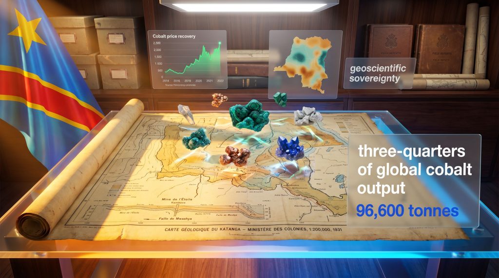
The collection accumulated during Belgian colonial administration of the Congo — spanning from 1885 through to independence in 1960 — is not a modest filing cabinet of historical curiosities. It is one of the most extensive mineral documentation exercises ever conducted on any territory in sub-Saharan Africa. Held at the Royal Museum for Central Africa in Tervuren, near Brussels, the archive encompasses materials that modern exploration programmes have not come close to replicating at national scale.
The composition of the collection reflects the methodological ambition of colonial-era geological science:
- Regional and district-level geological maps, including surveys dating to at least 1931, produced by the Belgian Ministry of Colonies' Map Service at scales useful for both strategic planning and field-level navigation
- Field expedition reports containing stratigraphic sequence descriptions, mineralogical observations, and structural geological assessments across multiple provinces
- Aerial photographic surveys capturing surface geology, topographic features, and drainage patterns across significant portions of the national territory
- Rock and drill core samples extracted from active and prospective mining zones, particularly within the Katanga Copperbelt
- Hydrogeological and structural datasets relevant to both mining feasibility and broader infrastructure planning
The Katanga Copperbelt: Where the Records Matter Most
The Katanga Copperbelt, straddling the southern DRC and northern Zambia, represents one of the most mineralogically endowed geological corridors on the planet. The belt hosts sediment-hosted stratiform copper-cobalt deposits of exceptional grade and lateral continuity, formed within the Neoproterozoic Katanga Supergroup sedimentary sequence. Colonial geological work in this region produced detailed subsurface documentation that remains directly relevant to exploration targeting today.
| Record Type | Estimated Geographic Coverage | Primary Mineral Focus |
|---|---|---|
| Geological maps (1:200,000 scale) | Katanga, Kasai, Congo Basin | Copper, cobalt, tin |
| Aerial photographic surveys | Partial national coverage | Structural geology |
| Field expedition reports | Multiple provinces | Lithium, uranium, coltan |
| Rock and sample catalogues | Mining concession zones | Copper, cobalt, gold |
A significant proportion of the DR Congo's landmass has not been subjected to modern systematic geological survey. For large sections of the country's interior, the colonial-era records may constitute the only existing systematic documentation of subsurface conditions, making their recovery a matter of economic sovereignty rather than historical sentiment alone.
Why Geoscientific Sovereignty Has Become a Strategic Imperative
The Congolese Mines Minister, Louis Watum Kabamba, engaged directly with Belgian and European Union officials to advance discussions on the digitisation and formal transfer of the records to Kinshasa. Following those discussions, both parties agreed to develop a joint digitisation and restitution roadmap, establish a bilateral task force to govern the process, and pursue EU co-funding mechanisms to support the technical programme.
The Congolese mining ministry has explicitly framed the recovery of these records as a step toward strengthening the country's geoscientific sovereignty — a concept with direct commercial implications. In practical terms, geoscientific sovereignty describes a nation's capacity to independently assess and commercially leverage knowledge of its own subsurface resources without dependence on foreign intermediaries.
The ministry's position is that a very large part of the DR Congo has not yet been explored, and that accelerating the discovery of new mineral deposits requires possession of every available piece of subsurface intelligence. Furthermore, this framing connects the historical archive to a thoroughly contemporary economic objective.
The commercial logic is not difficult to construct. The DRC:
- Supplies approximately three-quarters of global cobalt output
- Holds some of the world's largest confirmed copper reserves
- Contains lithium, coltan, cassiterite, and other transition-economy minerals across multiple geological provinces
- Has vast interior territories that remain geologically undercharacterised by contemporary standards
The KoBold Metals Access Dispute and What It Reveals About Geological Data Politics
Before the formal governmental engagement between Kinshasa and Brussels gained momentum, US-based mineral exploration company KoBold Metals — backed by investors including Bill Gates — signed an agreement with the DRC in 2025 to assist with digitising the colonial archive. The arrangement, however, encountered a significant institutional obstacle. As reported by Reuters, Belgian museum authorities declined to grant KoBold Metals exclusive access to the collection.
Their reasoning centred on a principle that has emerged as a defining fault line in critical mineral geopolitics: the question of whether a foreign private commercial entity should be permitted to access, and potentially leverage, millions of documents detailing a sovereign nation's geological endowment.
The museum's institutional position was structured around three distinct objections:
- Digital copies should be transmitted directly to Congolese governmental authorities, not routed through a commercial intermediary
- The digitisation process should be managed by the museum itself rather than outsourced to a commercial operator
- A Belgian government spokesperson confirmed the project was already progressing with EU funding, with digital copies being incrementally delivered to relevant Congolese agencies
The KoBold situation captures a structural tension that will increasingly define the critical minerals landscape. Private capital has both the technical capability and the financial motivation to digitise and exploit legacy geological datasets, but sovereign nations and their institutional custodians are beginning to recognise the asymmetric risk of allowing that to happen on terms set by the private sector.
This episode illustrates something deeper about geological data as an asset class. Unlike a mine or a processing plant, geological intelligence is non-rivalrous in theory but intensely rivalrous in practice. Once a private entity possesses a comprehensive digital map of a nation's subsurface mineralisation, that informational advantage can shape exploration licensing outcomes, acquisition strategies, and royalty negotiation dynamics for decades. Consequently, questions of access and control are growing ever more contentious within the broader landscape of mining geopolitics.
Cobalt Quotas and the Architecture of DRC Resource Nationalism
The push to recover DR Congo Belgium colonial-era geological maps does not exist as an isolated diplomatic initiative. It sits within a coherent, multi-instrument strategy by Kinshasa to assert greater control over every dimension of its mineral economy — from the data that guides exploration upstream to the volumes that reach global markets downstream.
The DRC cobalt export ban was among the most consequential supply-side interventions of recent years, and its evolution into a quota system has reshaped market expectations globally.
Key policy interventions along this timeline:
| Date | Policy Action | Strategic Objective |
|---|---|---|
| February 2025 | Cobalt export suspension | Arrest price decline from market oversupply |
| October 2025 | Quota system introduced | Replace blanket ban with structured supply management |
| 2026–2027 | Annual export cap set at 96,600 tonnes | Stabilise cobalt pricing and government revenue |
| March 2026 | DRC joins PanAfGeo+ INVEST initiative | Strengthen geological data infrastructure |
| 2026 (ongoing) | Geological archive restitution negotiations | Assert geoscientific sovereignty |
The cobalt export suspension produced measurable effects on global cobalt markets. Prices recovered from multi-year lows following the initial suspension announcement. Chinese refining operations, which process the majority of DRC cobalt output, faced tightened feedstock availability. Simultaneously, the supply constraint accelerated investment into cobalt-free battery chemistries, particularly lithium iron phosphate formulations, among major battery manufacturers.
The structural parallel to OPEC's oil production management model is instructive. Both represent resource-rich sovereign actors using supply-side discipline to influence global commodity pricing. The key difference is that the DRC is pursuing this strategy from a position of even greater market concentration: no single OPEC member controls 75 percent of global output of any commodity.
How Legacy Data Digitisation Creates Compounding Value for Modern Exploration
The practical pathway from dusty colonial archive to functioning exploration intelligence is more technically sophisticated than the diplomatic framing suggests. Here is how digitised historical geological records generate compounding value across the exploration lifecycle:
- Baseline mapping establishment: Historical surveys identify where surface and near-surface mineralisation was previously observed, creating geographically defined priority zones for subsequent modern geophysical surveys such as airborne electromagnetic and gravity gradiometry programmes
- Drill target refinement: Field reports and sample catalogues allow exploration geologists to define high-confidence drill targets without the expense of full greenfield reconnaissance, meaningfully reducing the capital required to reach first-pass resource estimation
- AI model training inputs: Digitised geological maps and expedition reports serve as training datasets for machine learning systems designed to identify geological patterns statistically associated with economic mineral deposits
- Investor risk premium reduction: Countries with comprehensive, publicly accessible geological databases attract exploration investment at lower risk premiums, improving the fiscal terms available to the host government
- Regulatory process streamlining: Digitised subsurface records enable regulators to evaluate exploration licence applications with complete geological context, reducing approval timelines and improving the quality of concession boundary decisions
The AI Acceleration Factor
The partnership between Eramet, Lithosquare, and BRGM represents a specific application of AI in mineral exploration to the challenge of critical metal discovery, with an initial geographic focus on African geological provinces. This matters for the DRC's archive recovery effort because it suggests that, once digitised, the colonial-era records could become training inputs for predictive geological models rather than simply static reference documents.
The technical mechanism involves training neural networks on known deposit locations and their associated geological signatures, then running those pattern-recognition algorithms across digitised legacy maps to identify analogous signatures in underexplored territory. Colonial-era maps, with their detailed hand-recorded mineralogical observations, may contain precisely the textural and structural geological information that such models require.
The next major ASX story will hit our subscribers first
Africa's Broader Geological Data Modernisation Movement
The DRC's effort to recover its colonial geological archive is one expression of a continent-wide push to modernise geoscientific data infrastructure and reposition African nations as more capable negotiating partners in global mineral value chains.
Key continental programmes reshaping exploration infrastructure:
- PanAfGeo+ Programme: EU-backed initiative supporting African geological survey agencies across multiple member states in upgrading mapping capabilities, data management systems, and technical workforce capacity. The DRC formally joined its INVEST component in March 2026.
- South Africa's Council for Geoscience and BHP Partnership: A collaboration targeting legacy geological datasets across southern Africa's mineralised corridors, aiming to unlock historical drill core and survey data for contemporary exploration use.
- Eramet, Lithosquare, and BRGM Collaboration: A three-way partnership deploying artificial intelligence tools to accelerate critical metal discovery, with Africa as the primary geographic focus for initial deployment.
The common thread across these initiatives is a recognition that geological data represents a category of infrastructure as consequential as roads or ports. Nations and companies that invest in curating, digitising, and intelligently deploying geological information will hold a structural advantage in the next phase of the critical minerals buildout.
The Geopolitical Dimensions of Colonial Geological Restitution
The broader colonial restitution debate has generally centred on cultural artefacts, artworks, and human remains. The DR Congo Belgium colonial-era geological maps dispute, however, occupies unusual terrain within that conversation because its stakes are explicitly commercial. This distinction reshapes the incentive structures for all parties involved.
Belgium's institutional interest centres on managing the process carefully to avoid setting precedents that could be applied to other colonial-era scientific and technical documentation. The DRC's governmental interest is in recovering data that could directly influence exploration licensing terms, royalty structures, and the competitiveness of its investment environment. The EU's interest involves positioning European institutions as constructive partners in African resource governance at precisely the moment when competition from Chinese and American capital in African mineral sectors is most intense.
If the complete colonial geological archive were digitised and made accessible to Congolese geological authorities within a defined timeframe, the downstream effects could include a meaningful reduction in the cost and timeline of new deposit identification in underexplored provinces, increased competition among international exploration firms for DRC concessions, and accelerated development of lithium and coltan resources that colonial surveys documented but never commercially prioritised.
Disclaimer: This article contains forward-looking analysis, scenario projections, and commentary on commodity markets. It does not constitute financial or investment advice. Readers should conduct their own research and consult qualified advisors before making investment decisions. Mineral exploration and commodity market outcomes are subject to significant uncertainty.
Key Takeaways: What the Colonial Geological Maps Dispute Signals for Investors and Industry
| Theme | Implication |
|---|---|
| Geoscientific sovereignty | Subsurface data is increasingly treated as a strategic national asset requiring active governance frameworks |
| Private capital access limits | Commercial exploration firms face institutional and political constraints on accessing sovereign geological intelligence |
| Supply chain vulnerability | Gaps in geological knowledge translate directly into exploration risk premiums and supply uncertainty for downstream industries |
| Colonial restitution economics | Historical data recovery carries measurable commercial value distinct from cultural restitution debates |
| AI and legacy data | Digitised historical records are becoming high-value training inputs for machine learning-driven mineral exploration |
| Cobalt market structure | DRC's supply management strategy mirrors commodity cartel logic, with implications for battery technology investment timelines |
The intersection of historical justice, technological capability, and critical mineral supply chain security has created an unusual convergence point in the DR Congo Belgium colonial-era geological maps dispute. What began as a diplomatic exchange over museum holdings has, consequently, evolved into a test case for how geoscientific intelligence will be governed, shared, and monetised in the energy transition economy. The outcome will carry implications that extend well beyond the borders of either nation involved.
Want to Track the Next Major Mineral Discovery Before the Broader Market Does?
Discovery Alert's proprietary Discovery IQ model delivers real-time alerts on significant ASX mineral discoveries — instantly transforming complex geological and commodity data into actionable investment insights for both short-term traders and long-term investors. Explore historic examples of exceptional discovery returns and begin your 14-day free trial today to position yourself ahead of the market.