June 15, 2026
The Geological Data Problem That Major Mining Operations Can No Longer Afford to Ignore
Across the global mining industry, a structural inefficiency has persisted for decades beneath the surface of otherwise sophisticated operations. As ore bodies grow progressively deeper, structurally more complex, and geometrically irregular, the tools used to understand them have in many cases failed to keep pace. The consequences are not abstract. Misclassified ore, unexpected geotechnical failures, and resource estimate revisions can translate directly into capital write-downs, delayed production, and reduced project bankability.
The deeper problem is not a lack of data. Modern drilling programs generate enormous volumes of it. The challenge is that this data has historically existed in fragments, scattered across paper logs, spreadsheets, physical core trays, disconnected databases, and reports authored by teams that rarely share a common technical language. When geologists, geotechnical engineers, and resource estimation specialists work from different versions of the subsurface picture, compounding uncertainty becomes structurally embedded in the mine plan itself.
This is precisely the landscape that integrated Seequent subsurface imaging platforms are designed to address, and why operations run by companies including Anglo American and OceanaGold have adopted these systems to reshape how geological intelligence is built, managed, and applied across the mine lifecycle.
When big ASX news breaks, our subscribers know first
Why Data Silos Are the Most Underestimated Risk in Mining Geology
The Hidden Latency in Manual Correlation Workflows
At many large-scale operations, geotechnical work has historically involved manually correlating data pulled from drillhole logs, physical core trays, geotechnical reports, and geological maps. Each of these sources represents a snapshot from a different point in time, captured by a different team, and stored in a format that was never designed for integration with the others.
The result is a workflow defined by latency. Geological models are updated in discrete, campaign-based cycles rather than continuously. Anomalous drill intersections may sit in a logging sheet for weeks before they are incorporated into an interpretive model. In geotechnically complex environments, that delay carries real operational risk.
Several compounding factors make this situation increasingly untenable:
- Global average ore grades have declined materially over the past two decades, meaning resource characterisation must be more precise than ever to deliver economic outcomes
- Ore bodies being brought into production today are frequently deeper, structurally more complex, and geometrically irregular compared to previous generations of deposits
- ESG reporting obligations now require geological data to be auditable and defensible, raising the compliance burden on data management practices
- Experienced geologists are retiring faster than they can be replaced, making knowledge capture and workflow automation strategically critical
What Subsurface Imaging Actually Means in a Mining Context
Subsurface imaging in mining refers to the integrated process of capturing, digitising, and modelling drillhole core data, geological imagery, and spatial datasets to construct accurate three-dimensional representations of ore bodies and surrounding rock mass. The goal is to convert raw physical data into actionable geological intelligence that can be updated continuously as new information arrives.
This is distinct from traditional geological modelling in one critical respect: the model is treated as a living document rather than a static deliverable. As new drilling data becomes available, the model evolves. As geotechnical conditions change, they are reflected in the subsurface interpretation in near-real time. This principle, commonly referred to in the industry as adaptive engineering, represents a fundamental shift in how mining companies manage geological uncertainty.
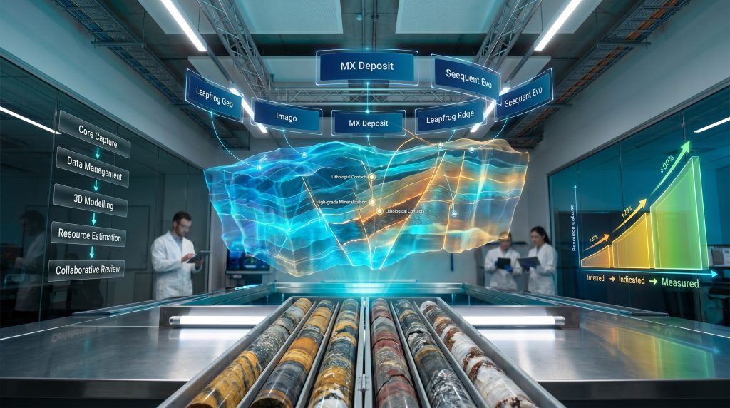
Seequent's Platform Architecture: How the Components Fit Together
A Unified Pipeline from Core Tray to Resource Estimate
Seequent operates within the Bentley Systems group and has developed a suite of interconnected tools that collectively address every stage of the mining geology value chain. Rather than requiring geologists to manually transfer data between standalone applications, the platform is designed around a connected data pipeline.
| Platform Component | Primary Function | Mining Application |
|---|---|---|
| Leapfrog Geo | 3D dynamic geological modelling | Ore body interpretation, structural geology |
| Imago | Cloud-based core image management | Drillhole visualisation, image validation |
| MX Deposit | Drillhole data management | Sample tracking, data integrity |
| Leapfrog Edge | Resource estimation and domaining | Grade modelling, variography |
| Central | Collaborative data sharing | Model version control, audit trails |
| Seequent Evo | Unified cloud platform | Machine learning, integrated workflows |
Data moves through this system in a logical sequence. High-resolution core photography captured through Imago feeds into structured drillhole records within MX Deposit. Those records flow into Leapfrog Geo, where geologists construct dynamic implicit geological models. Resource estimation workflows in Leapfrog Edge draw directly from the geological framework established in Leapfrog Geo. All model iterations are managed through Central, providing version control and audit traceability. Furthermore, Seequent Evo acts as the connective tissue across the entire ecosystem, enabling cloud-based compute and machine learning integration.
The architecture eliminates a class of inefficiency that has historically been invisible in mining operations: the friction cost of moving data between tools, reconciling format inconsistencies, and managing conflicting model versions across teams.
From Drill Core to Geological Model: A Step-by-Step Process
How Seequent Subsurface Imaging Works in Practice
Understanding how these tools function in sequence is essential for appreciating why the integrated approach produces qualitatively different outcomes compared to legacy workflows.
-
Core Recovery and Image Capture – Drill core is photographed using standardised imaging protocols. Imago ingests high-resolution images into a cloud-accessible repository, making them immediately available to remote teams without the need to physically access core storage facilities.
-
Image Validation and Annotation – Geologists review core imagery within the Imago portal, annotating lithological contacts, mineralisation zones, structural features, and alteration patterns. This step creates a documented interpretive record that is traceable and auditable.
-
Linkage to Drillhole Database – Imago imagery is linked to corresponding depth interval data within MX Deposit, ensuring that every image is spatially anchored to a precise location within the drill programme. Accurate geological logging codes are essential at this stage to maintain data integrity across the pipeline.
-
Three-Dimensional Model Construction – Validated drillhole data and associated imagery feed into Leapfrog Geo, where geologists build dynamic implicit geological models. 3D geological modelling is particularly powerful because it generates surfaces automatically from data constraints, allowing multiple geological interpretations to be tested rapidly.
-
Resource Estimation and Grade Control – Leapfrog Edge uses the geological framework to support domain boundary definition, variogram modelling, and grade interpolation using kriging or simulation methods.
-
Collaborative Review and Version Control – All model iterations are managed through Central, enabling multi-disciplinary teams to work from a single, auditable source of geological truth without the risk of conflicting versions circulating across email chains.
The shift from manual core logging to cloud-based image management can significantly compress interpretation timelines, allowing geological models to be updated as new drilling data arrives rather than in discrete, time-lagged batches. This has particular operational value in active mining environments where geological conditions ahead of the development face need to be understood as rapidly as possible.
Machine Learning and the Next Frontier in Core Interpretation
AI-Assisted Lithology Classification
One of the more technically significant aspects of the Seequent ecosystem is the machine learning functionality embedded within Seequent Evo. This capability is designed to identify geological features directly from core images, supporting automated lithology classification that reduces the manual logging burden on individual geologists.
In high-volume drilling programmes, manual logging at scale creates genuine bottlenecks. A single geologist can only process so many metres of core per day with sufficient accuracy, and in remote locations, qualified personnel are often scarce. Automated classification tools do not eliminate the need for expert oversight, but they can pre-process large image datasets, flagging intervals of interest and providing a first-pass interpretation that trained geologists can then validate and refine.
Practical Limits and Emerging Opportunities
It is important to apply appropriate nuance to claims about AI in geological interpretation. Machine learning models trained on core imagery require datasets that are genuinely representative of the specific geological setting in which they will be applied. A model trained on porphyry copper deposits in Chile may perform poorly when applied to lateritic nickel deposits in Brazil. Performance varies significantly across deposit types, mineralogical complexity, and alteration styles.
Emerging developments in this space include the integration of hyperspectral imaging data with conventional core photography. Hyperspectral sensors can detect mineral assemblages that are invisible to the human eye, capturing spectral signatures associated with specific clay minerals, sulphide phases, and alteration zones. When combined with geochemical assay results and visual core imagery, these datasets create multi-dimensional subsurface records with substantially richer interpretive potential than any single data type alone. In fact, Seequent's recent advances in image analysis illustrate precisely how this convergence is being operationalised at scale.
This convergence of spectral, visual, and geochemical data represents one of the more genuinely transformative directions in mining geology, with the potential to reduce the dependence on costly and time-consuming laboratory analysis for early-stage deposit characterisation.
Adaptive Engineering in Practice: What It Means for Real Mining Operations
Continuous Model Evolution vs. Campaign-Based Updates
The concept of adaptive engineering is central to understanding the operational value of integrated subsurface imaging platforms. Traditional mine geology has operated on fixed model update cycles tied to drilling campaigns. A major resource model update might occur once or twice per year, with the geological picture remaining essentially static between campaigns.
Adaptive engineering rejects this model. By maintaining a continuously updated geological framework, mining teams can respond to unexpected subsurface conditions as they are encountered rather than waiting for the next scheduled model revision. This has direct implications across several operational domains:
- Open pit operations: Updated slope geometry models informed by fresh structural mapping can reduce the risk of bench-scale and inter-ramp failures
- Underground development: Geology ahead of the development face can be interpreted from recent drilling, informing support design and development sequencing decisions
- Grade control: Near-real-time updates to grade control models as blast hole data is incorporated can reduce ore/waste misclassification and improve mill feed predictability
- Geotechnical risk management: Continuously updated rock mass characterisation data supports more dynamic geotechnical risk zoning
Anglo American's Barro Alto Nickel Operation as a Case Study
Anglo American's Barro Alto nickel operation in Brazil provides a concrete illustration of how legacy workflows create operational constraints. The site's geotechnical work historically involved correlating data from multiple disparate sources, all managed manually. This approach introduced the full suite of problems associated with siloed data management: latency in model updates, inconsistency between teams, and compounding interpretive uncertainty as the operation progressed into more geologically variable ground.
The adoption of integrated subsurface imaging tools directly addressed these structural inefficiencies by creating a connected data environment where geological, geotechnical, and resource estimation teams could work from shared, version-controlled information. The operational significance of this shift extends beyond efficiency gains. At a nickel operation where ore grade variability has direct consequences for processing performance, tighter geological domain definition translates into measurable improvement in reconciliation between resource model predictions and actual mill feed grades.
The next major ASX story will hit our subscribers first
Seequent Integrated Workflows vs. Legacy Approaches: A Direct Comparison
| Workflow Stage | Legacy Approach | Seequent Integrated Approach |
|---|---|---|
| Core Logging | Manual paper or spreadsheet records | Cloud-based image capture with digital annotation |
| Data Management | Siloed databases, manual transfer | Unified drillhole database with full audit trail |
| Geological Modelling | Static, campaign-based updates | Dynamic implicit models updated continuously |
| Team Collaboration | Email-based file sharing | Version-controlled model sharing via Central |
| Resource Estimation | Disconnected from geological model | Directly linked to Leapfrog Geo framework |
| ML Integration | Not applicable | AI-assisted lithology identification via Seequent Evo |
Resource Classification, Capital Allocation, and Project Valuation Implications
Why Geological Model Quality Has Direct Financial Consequences
The business case for integrated subsurface imaging extends well beyond operational efficiency. Geological model confidence sits at the foundation of every major financial decision in the mining project lifecycle.
Under internationally recognised reporting standards including JORC (Australia and Asia-Pacific), NI 43-101 (Canada), and SAMREC (South Africa), the classification of mineral resources from Inferred through Indicated to Measured status is fundamentally a function of geological confidence. Higher-resolution data, more defensible interpretations, and auditable modelling workflows all contribute directly to the ability to upgrade resource classification categories.
The financial implications cascade from there:
- Project NPV: Higher-classification resources attract lower technical risk premiums in discounted cash flow models, increasing calculated net present value
- Feasibility study quality: Measured and Indicated resources support pre-feasibility and definitive feasibility studies with greater statistical robustness
- Bankability: Lenders and project finance providers apply greater confidence to projects underpinned by high-classification resource estimates supported by auditable geological workflows
- M&A due diligence: Acquirers assessing geological risk in transaction processes can interrogate model history and data provenance when audit trails are maintained through platforms like Central
The Compounding Value of Integrated Geological Data
One of the less frequently discussed advantages of integrated subsurface imaging platforms is the compounding analytical value they generate over time. Historical drilling datasets stored in a structured, cloud-accessible format become reusable assets that can be reinterpreted as geological understanding evolves or as new analytical techniques become available.
In contrast, data locked in legacy formats or physical logs represents a form of value destruction. When experienced geologists retire, their interpretive knowledge leaves with them unless it has been captured in auditable, structured digital form. Platforms like Seequent's ecosystem institutionalise geological knowledge rather than allowing it to reside with individuals — a capability that is becoming increasingly strategically significant as the industry faces accelerating workforce turnover.
Frequently Asked Questions: Seequent Subsurface Imaging in Mining
What is Leapfrog Geo used for in mining?
Leapfrog Geo is a three-dimensional geological modelling platform that builds dynamic implicit models of ore bodies and surrounding geology from drillhole data, geophysical surveys, and surface mapping. Its implicit modelling engine automatically generates geological surfaces from data constraints, allowing geologists to test multiple interpretations rapidly and update models as new information arrives.
How does Imago improve core image management?
Imago is a cloud-based platform for capturing, storing, and managing high-resolution geoscientific images, primarily drill core photography. It links images directly to drillhole interval data, making them accessible to remote teams and integrating them into modelling platforms for enhanced subsurface visualisation and interpretation.
What is Seequent Evo and how does it differ from earlier tools?
Seequent Evo is a cloud-native platform connecting Leapfrog Geo, Imago, MX Deposit, and Central within a single integrated environment. It adds cloud compute capabilities and machine learning functionality, including AI-assisted geological feature identification from core imagery, representing a meaningful step beyond the functionality available in earlier standalone tools.
Can Seequent's tools support geotechnical as well as resource geology?
Yes. Structural data captured during core logging — including fracture frequency, rock quality designation, and discontinuity orientation — can feed directly into geotechnical models. This supports slope stability analysis, underground support design, and rock mass characterisation across the full mine lifecycle. Consequently, interpreting drill results within this integrated framework yields significantly richer geotechnical intelligence than isolated manual methods.
Which resource reporting standards does Seequent support?
Seequent's tools are designed to support resource estimation workflows aligned with JORC, NI 43-101, and SAMREC standards through auditable data management and traceable modelling workflows. However, drill results interpretation remains the responsibility of the competent person, with the platform serving to support and document the process rather than replace professional judgement.
Key Takeaways for Mining Professionals and Investors
The case for integrated Seequent subsurface imaging in mining ultimately rests on a straightforward but frequently undervalued proposition: the quality of every downstream decision in the mine lifecycle is bounded by the quality of the subsurface understanding that underpins it.
- Integrated platforms convert fragmented geological data into a continuous, cloud-connected intelligence workflow that evolves with the mine
- The combination of Imago, Leapfrog Geo, MX Deposit, Leapfrog Edge, Central, and Seequent Evo addresses every stage of the geology value chain within a single connected environment
- Machine learning integration within Seequent Evo is accelerating the automation of lithological interpretation, with hyperspectral imaging representing an emerging frontier in multi-dimensional core analysis
- Adaptive engineering principles enabled by dynamic modelling and real-time data integration are reshaping how major operations manage geological uncertainty
- The financial consequences of geological model quality extend to resource classification, project NPV, feasibility study robustness, and transaction risk pricing in M&A processes
- Institutional knowledge capture through structured digital workflows addresses a growing talent retention challenge across the global mining industry
Disclaimer: This article contains forward-looking statements and references to projected operational and financial outcomes. These represent informed analysis based on publicly available information and industry trends, and should not be construed as investment advice. Readers should conduct independent due diligence before making any investment or operational decisions.
Readers seeking further technical coverage of subsurface imaging technologies and mining geology workflows can explore additional content at miningmagazine.com, which provides ongoing analysis of emerging technologies across the global mining sector.
Want to Know When a Major Mineral Discovery Hits the ASX Before the Broader Market Does?
Discovery Alert's proprietary Discovery IQ model scans ASX announcements in real time, instantly identifying significant mineral discoveries and turning complex geological data into actionable investment insights — explore historic discovery returns to understand what's at stake, and begin your 14-day free trial at Discovery Alert to position yourself ahead of the market.