July 8, 2026
The Operational Gap That Made Aerial Intelligence Inevitable
For most of the twentieth century, the flow of information inside a mine was fundamentally constrained by human mobility. A surveyor could only be in one place at a time, a manned helicopter survey cost tens of thousands of dollars per flight, and a rope-access inspector could only assess what their body could physically reach. The result was a chronic data latency problem: decisions about slope stability, stockpile volumes, and infrastructure integrity were being made on information that was days, weeks, or even months old by the time it reached the engineers who needed it.
That latency carried a real financial cost. In large open-pit operations, a single unexpected slope failure can halt production for weeks. A miscalculated stockpile volume feeds directly into incorrect inventory reporting, which ripples through logistics planning, sales commitments, and financial reconciliation. The structural limitations of ground-based surveying were not just an inconvenience; they were a compounding source of operational risk embedded into the core of how mines functioned.
The maturation of drone technology in mining operations has fundamentally altered this equation. The convergence of capable UAV hardware, lightweight sensor payloads, and AI-powered mining efficiency tools has created an aerial intelligence layer that mines previously could not access at any practical cost. Understanding how that layer works, and what it changes across the full mining value chain, is now a critical competency for anyone operating in or investing in the resources sector.
When big ASX news breaks, our subscribers know first
What Drone Technology in Mining Operations Actually Encompasses
Platform Architecture: Not All UAVs Are Equal
The term drone covers a wide spectrum of hardware configurations, each suited to different tasks within a mine environment.
- Fixed-wing UAVs are optimised for large-area coverage, capable of covering hundreds of hectares per flight on a single battery charge, making them well-suited to regional exploration surveys and large open-pit mapping campaigns.
- Multirotor platforms sacrifice range for precision and hover capability, enabling close-range inspection of conveyor structures, processing plant components, and tailings storage facility (TSF) embankments.
- Hybrid VTOL (vertical take-off and landing) platforms combine fixed-wing efficiency with multirotor flexibility, an increasingly popular choice for mine sites where both scale and precision are required within the same operational day.
- Drone-in-a-box systems represent the most operationally advanced deployment model, with the drone launching, completing its mission, and returning to a weatherproof charging station with no human interaction required.
The Sensor Stack That Separates Mining Drones from Commercial UAVs
What distinguishes a mining-grade UAV from a commercial photography drone is almost entirely the sensor payload. The airframe is often secondary. Key sensor types deployed in mine environments include:
- LiDAR (Light Detection and Ranging): Generates dense point clouds with centimetre-level accuracy, essential for highwall face modelling, pit floor mapping, and haul road design.
- RGB photogrammetry cameras: Used for orthomosaic generation and photogrammetric 3D reconstruction of stockpiles, blast zones, and surface features.
- Multispectral and hyperspectral sensors: Enable mineral mapping and vegetation health assessment by capturing reflectance data across wavelengths invisible to standard cameras.
- Thermal imaging payloads: Detect heat anomalies in electrical infrastructure, conveyor drive systems, and processing equipment, supporting predictive maintenance in mining workflows.
- Gas detection sensors: Measure atmospheric composition in post-blast environments and confined underground spaces, identifying hazardous concentrations before human entry.
- SLAM (Simultaneous Localisation and Mapping) systems: Allow drones to build real-time spatial maps without GPS, a capability that unlocks underground deployment in tunnels and stopes where satellite signals are entirely absent.
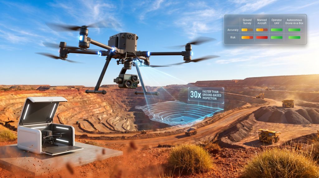
Key Insight: Drone surveys in mining environments can be completed up to 30 times faster than equivalent ground-based inspections, with same-day data processing enabling near-real-time operational decisions that were previously impossible within conventional survey cycles.
What Are the Core Technical Applications Across the Mining Value Chain?
Stage 1: Exploration and Geological Intelligence
At the exploration phase, drone technology in mining operations delivers value by reducing both the cost and environmental footprint of data collection in remote or ecologically sensitive areas. UAVs equipped with multispectral and hyperspectral sensors can discriminate between surface mineralogy types based on spectral reflectance signatures, generating mineral maps that guide drill targeting without requiring extensive ground disturbance.
Digital Surface Models (DSMs) and Digital Elevation Models (DEMs) generated from aerial surveys underpin resource estimation workflows, feeding directly into 3D geological modelling software. For junior explorers operating in remote terrain, drone-based reconnaissance can compress the early-stage data collection timeline from months to weeks.
Stage 2: Active Mine Planning and Pit Optimisation
In operating open-pit mines, LiDAR-derived 3D terrain models have progressively replaced traditional total station surveys for a broad range of planning tasks, including excavation boundary definition, haul road gradient optimisation, and blast pattern design. The accuracy achievable with RTK (Real-Time Kinematic) and PPK (Post-Processed Kinematic) corrected photogrammetry now rivals, and in many cases exceeds, that of conventional ground survey methods.
Critically, the frequency advantage changes the planning cycle. Where a traditional manned survey might be scheduled quarterly due to cost, a drone-based survey can be run weekly or even daily, enabling ore block model updates that reflect current dig face conditions rather than conditions from three months ago.
Stage 3: Stockpile Management and Inventory Accuracy
Stockpile volume measurement is one of the highest-ROI entry points for drone programs in mining. Manual stockpile surveys are labour-intensive, slow, and subject to significant human error, particularly for irregularly shaped or high-gradient piles. Drone-based photogrammetric volume calculations, when properly calibrated with ground control points, deliver results within 1-2% of actual volume for well-structured stockpiles.
The inventory reconciliation implications are substantial. Persistent volume discrepancies between physical stockpile measurements and system records represent real financial exposure in terms of inaccurate cost accounting, incorrect logistics scheduling, and flawed sales forecasting. High-frequency autonomous drone audits reduce this reconciliation risk continuously rather than just at survey intervals.
Stage 4: Infrastructure and Equipment Condition Monitoring
Conveyor systems, processing plant structures, and TSF embankments all require regular inspection regimes, and all three represent environments where placing human inspectors introduces meaningful risk. Drone-based inspection using RGB and thermal payloads enables condition assessment of large infrastructure assets without halting production or requiring rope-access crews.
Thermal imaging, in particular, has demonstrated strong utility in identifying early-stage bearing failures, electrical hotspots, and friction anomalies in conveyor drive systems long before visible symptoms appear, enabling planned maintenance interventions rather than emergency shutdowns.
Stage 5: Highwall Inspection and Slope Stability Surveillance
Highwall failure is among the highest-consequence hazard categories in open-cut mining. Displacement of even a small section of an unstable highwall face can result in fatalities, equipment losses, and extended production halts. Historically, assessing highwall face conditions required either rope-access inspection (placing workers directly in the hazard zone) or periodic photogrammetric surveys from manned aircraft.
UAV-based highwall inspection programs now allow geotechnical engineers to capture high-resolution face data, identify tension cracks and overhang geometries, and detect early-stage displacement indicators without any human entry into the risk zone. When combined with change-detection algorithms applied across sequential drone datasets, subtle surface movements that precede larger failures can be identified days or weeks in advance.
Stage 6: Underground Mine Mapping and Confined Space Navigation
Underground drone deployment has historically been constrained by three technical barriers: the complete absence of GPS signals, the presence of dust and humidity that can compromise sensor systems, and the confined, complex geometry of underground excavations. SLAM-equipped compact multirotor platforms have progressively resolved each of these constraints.
SLAM technology enables a drone to construct a real-time geometric map of its surroundings using onboard sensors (typically LiDAR and depth cameras), using that map for autonomous navigation without any external positioning reference. This has opened up a range of underground applications that were previously impractical:
- Tunnel and drive mapping for as-built verification against mine design
- Ventilation network assessment, including airflow modelling based on geometric data
- Stope inspection following blasting, enabling volume calculation without human entry into freshly blasted voids
- Post-seismic event reconnaissance, enabling structural assessment within hours of an event rather than days
- Gas detection sweeps in post-blast environments before miner re-entry
Safety Benchmark: Drone-in-a-box systems operating on autonomous schedules can assess hazardous zones within minutes of a triggering event, a capability that previously required hours of manual preparation and carried significant personnel risk. In documented underground deployments, SLAM-equipped drones have been used to complete emergency reconnaissance within 48 hours of seismic events, eliminating the need for human entry before structural clearance is confirmed.
Stage 7: Environmental Compliance and Rehabilitation Monitoring
Environmental monitoring obligations are growing in scope and reporting frequency across most major mining jurisdictions. Furthermore, drone technology in mining operations addresses this directly by enabling automated, time-stamped, georeferenced evidence capture for regulatory reporting purposes.
Key environmental monitoring applications include:
- Sediment dispersion tracking in surface water catchments adjacent to mine sites
- Dust plume monitoring using multispectral sensors
- Vegetation health assessment across rehabilitation zones using NDVI (Normalised Difference Vegetation Index) derived from multispectral imagery
- Aerial seed dispersal programs for large-scale rehabilitation of post-mining landscapes
- TSF embankment condition monitoring for early identification of seepage, cracking, or erosion
How Do the Economics of Drone Deployment Compare to Legacy Survey Methods?
The economic case for drone adoption in mining is most clearly illustrated by comparing cost structures across competing survey methodologies.
| Survey Method | Relative Cost | Turnaround Time | Accuracy Level | Human Risk Exposure |
|---|---|---|---|---|
| Ground-based manual survey | High (labour-intensive) | Days to weeks | Moderate | High |
| Manned aerial survey (helicopter/fixed-wing) | Very High | Days | High | Moderate |
| Operator-piloted UAV | Low to Moderate | Hours | Very High | Low |
| Autonomous drone-in-a-box | Low | Minutes to Hours | Very High | Minimal |
The cost differential between manned aerial surveys and autonomous drone programs is substantial, but the more strategically significant comparison is frequency-adjusted cost. A manned helicopter survey conducted quarterly carries a much lower nominal cost than four autonomous drone surveys per week, until the decision quality improvement from higher-frequency data is factored in. For large open-pit operations where excavation rates are high and conditions change rapidly, the value of weekly versus quarterly survey cycles often dwarfs the survey cost itself.
ROI Drivers That Finance Teams Should Understand
The financial case for drone programs in mining is not simply about replacing survey costs on a like-for-like basis. The compounding ROI drivers include:
- Unplanned downtime reduction: Early detection of infrastructure faults, slope movement, and equipment anomalies translates directly into avoided emergency shutdowns, which in large operations can cost millions of dollars per day.
- Stockpile reconciliation accuracy: Improved volume measurement accuracy reduces inventory write-offs and supports more accurate cost accounting.
- Compliance cost avoidance: Automated, continuous environmental monitoring records reduce the cost and risk of regulatory compliance reporting.
- Insurance and liability reduction: Some insurers are beginning to recognise continuous drone-based monitoring programs as risk-reduction measures that justify premium adjustments, particularly for TSF monitoring.
What Are the Safety Transformation Outcomes of UAV Integration?
Removing Workers from the Hierarchy of Controls Equation
The traditional hierarchy of controls places elimination of the hazard above all other risk management strategies. In mining, many of the highest-severity hazards have historically been impossible to eliminate because human access to those zones was operationally necessary. Drone technology fundamentally changes this by making human entry unnecessary for a widening range of inspection and assessment tasks.
The categories where this substitution has the greatest safety impact include:
- Highwall and open-pit slope inspection: Removes the need for rope-access or proximity inspections of potentially unstable faces.
- Underground post-blast re-entry assessment: Drones enter freshly blasted headings before miners, confirming atmospheric safety and structural condition.
- TSF embankment inspection: Eliminates the need for personnel to walk embankment crests and slopes of facilities that can fail catastrophically.
- Confined space entry for infrastructure inspection: Drones enter culverts, sumps, tanks, and other confined spaces that would otherwise require full confined space entry procedures.
Mining remains one of the world's most hazardous industries by fatality rate. According to data compiled by the International Labour Organization, the mining sector accounts for a disproportionate share of global workplace fatalities relative to its workforce size, with ground instability and confined space incidents representing two of the leading causal categories. Both are directly addressed by drone substitution programs. According to drone deployment specialists, underground UAV programs are increasingly regarded as essential safety infrastructure rather than optional technology additions.
What Technology Trends Are Defining the Next Generation of Mining Drones?
AI-Augmented Analytics: From Raw Data to Operational Intelligence
The current frontier in drone technology is not the drone itself, but the analytical intelligence applied to the data it generates. First-generation drone programs captured data that humans then manually interpreted. Emerging AI-augmented workflows automate the interpretation layer, and consequently, these advances are closely aligned with broader data-driven mining operations strategies, enabling:
- Automated change detection between sequential drone datasets, flagging surface movement, new cracking, or stockpile volume changes without manual comparison
- Predictive failure modelling that integrates drone-derived condition data with historical maintenance records to forecast equipment failure windows
- Anomaly detection algorithms trained on site-specific baseline data, reducing false positive rates compared to generic models
- Automated compliance reporting generation from drone-captured environmental monitoring data
Drone-in-a-Box and Fully Autonomous Site Monitoring
Drone-in-a-box systems represent the operational model toward which the industry is converging. These systems house the drone, its charging infrastructure, and often edge computing hardware within a weatherproof enclosure permanently installed at the mine site. Missions can be triggered by time-based schedules, alarm events (seismic triggers, weather threshold crossings, process upsets), or remote operator instruction.
Edge computing capability is increasingly important in this context. Rather than transmitting raw imagery data to cloud processing infrastructure, edge-capable drone-in-a-box systems process data locally, generating actionable outputs (change detection alerts, volume estimates, anomaly flags) within minutes of mission completion. This is particularly valuable in remote mine sites with limited or expensive satellite bandwidth.
Swarm Technology and Multi-Drone Coordination
Swarm drone technology, in which multiple UAVs coordinate to execute a single large-scale mission simultaneously, remains at an early stage of maturity within the mining sector but represents a strategically important trajectory. For very large open-pit operations covering multiple square kilometres, single-drone survey missions are time-constrained by flight endurance.
Coordinated multi-drone swarms divide the survey area across multiple airframes, reducing total mission time proportionally. Current commercial adoption of swarm technology in mining is limited, but purpose-built multi-drone coordination software is advancing rapidly, and several specialist operators are conducting large-scale open-pit surveys using coordinated two-to-four drone deployments as an intermediate step toward full swarm operations.
The next major ASX story will hit our subscribers first
What Challenges and Regulatory Constraints Are Slowing Adoption?
The BVLOS Barrier
The most operationally significant regulatory constraint on drone programs in mining is the line-of-sight requirement imposed by civil aviation authorities in most jurisdictions. Most mining operations span areas far larger than a single visual observer can monitor, meaning that autonomous drone-in-a-box programs technically require Beyond Visual Line of Sight (BVLOS) approval to operate legally without a dedicated spotter for every mission.
BVLOS approval pathways exist in Australia (administered by CASA), the United States (FAA Part 107 waiver system), Canada (Transport Canada), and South Africa (SACAA), but obtaining site-specific approval is a process that can take months and requires demonstrating specific safety cases. This regulatory friction is one of the primary factors slowing the transition from periodic piloted drone surveys to continuous autonomous monitoring at many mine sites. For a comprehensive overview of the regulatory landscape, drone compliance requirements provide detailed jurisdiction-specific guidance for mining operators.
The Build-vs-Buy Decision
For mining operations considering drone program development, the foundational strategic question is whether to develop internal UAV capabilities or engage specialist service providers. In addition, the role of AI in drilling and blasting is increasingly intersecting with drone programs, making internal capability development a more strategic consideration than it once was.
| Factor | Internal Program | Contracted Service Provider |
|---|---|---|
| Upfront capital cost | High | Low |
| Ongoing cost structure | Primarily fixed (equipment, staff) | Variable (per-mission or retainer) |
| Data security and sovereignty | Higher control | Dependent on contract terms |
| Operational flexibility | High | Constrained by provider scheduling |
| Capability depth | Depends on hiring | Access to specialist expertise |
| Scalability | Requires investment | More immediately scalable |
Larger mining operations with multiple active sites are increasingly building internal drone programs as a strategic asset, reasoning that the volume of work justifies the fixed cost base and that data sovereignty considerations favour keeping aerial data in-house. Smaller operations with periodic needs often find contracted service providers more cost-effective.
Strategic Consideration: As drone programs mature from project-based deployments to permanent site infrastructure, the governance, data sovereignty, and cybersecurity frameworks surrounding UAV operations become mission-critical considerations, not afterthoughts to be addressed once the program is already operational.
How Do Open-Pit and Underground Mining Applications Differ?
The application architecture for drone technology differs substantially between surface and underground mining contexts.
| Dimension | Open-Pit Mining | Underground Mining |
|---|---|---|
| Primary drone type | Fixed-wing or large multirotor | Compact multirotor with SLAM |
| Key sensor payload | LiDAR, RGB, multispectral | SLAM, gas detection, thermal |
| Primary use case | Surveying, slope monitoring, stockpile | Tunnel mapping, ventilation, emergency recon |
| Autonomy level | High (drone-in-a-box viable) | Moderate (semi-autonomous in structured tunnels) |
| Regulatory complexity | Moderate (BVLOS considerations) | Lower (private airspace underground) |
| Key technical challenge | Large area coverage efficiency | GPS-denied navigation and confined geometry |
One underappreciated distinction: underground drone programs actually face fewer regulatory hurdles than surface programs in most jurisdictions, because underground airspace is entirely private and not subject to civil aviation authority oversight in the same way. This means that BVLOS-equivalent autonomous operations can proceed underground without the approval processes required on surface, which has made underground drone adoption in some respects faster than surface adoption despite the more complex technical environment.
The Strategic Roadmap for Mining Drone Program Development
Phase 1: Pilot and Proof of Concept
The lowest-risk entry point for most operations is a single high-value use case, typically stockpile volume measurement or highwall inspection, where drone-derived outputs can be directly compared against existing data to validate accuracy and quantify value. Establishing baseline metrics before the pilot begins is essential to producing credible ROI evidence that justifies subsequent investment.
Phase 2: Operational Integration
Successful pilots need to be connected to operational workflows to deliver sustained value. This means:
- Building internal data processing capability or establishing reliable third-party processing pipelines
- Establishing data format compatibility between drone outputs (point clouds, orthomosaics, DSMs) and mine planning software
- Training relevant personnel in UAV regulatory compliance, data quality assurance, and output interpretation
- Defining governance frameworks for data storage, access control, and retention
Phase 3: Autonomous and Continuous Monitoring
The highest-value operating model transitions from periodic drone missions to permanent autonomous monitoring infrastructure. This phase requires:
- Physical installation of drone-in-a-box systems at strategic site locations
- Integration with site alarm and monitoring systems to enable event-triggered missions
- Pursuit of BVLOS regulatory approval for full-site autonomous coverage
- Expansion of sensor payload capabilities to address additional use cases identified during earlier phases
Frequently Asked Questions: Drone Technology in Mining Operations
What types of drones are most commonly used in mining?
Fixed-wing platforms for large-area exploration surveys, compact multirotors for precision inspection and underground deployment, and hybrid VTOL platforms for operations requiring both coverage and hover capability. Platform selection should be driven by mission type and site geometry rather than brand preference.
How accurate are drone surveys compared to traditional methods?
With RTK or PPK GPS correction and properly established ground control points, photogrammetric drone surveys can achieve horizontal and vertical accuracy within 1-3 centimetres under good conditions. LiDAR payloads deliver comparable accuracy with less dependence on surface texture. Accuracy degrades with increasing flight altitude, sparse ground control, and strong atmospheric turbulence.
Can drones operate autonomously at mine sites without a human pilot?
Yes, within regulatory constraints. Drone-in-a-box systems can execute fully autonomous missions, but operating beyond visual line of sight without on-site observer coverage requires BVLOS approval in most jurisdictions. Regulatory pathways for BVLOS approval exist in all major mining countries but require documented safety cases and site-specific assessment.
What is the typical cost saving from switching to drone-based surveys?
The direct survey cost comparison typically shows a 60-80% cost reduction versus equivalent manned aerial surveys for large open-pit applications. However, the more strategically significant savings come from decision quality improvements, unplanned downtime avoidance, and compliance cost reduction, categories that are harder to quantify but often exceed direct survey cost savings in total value.
How are drones integrated with existing mine management systems?
Drone-generated data products (point clouds, orthomosaics, DEMs, and DSMs) are ingested into mine planning software including Leapfrog, Vulcan, Deswik, and equivalent platforms. API-level integrations are increasingly available for connecting drone data platforms directly to ERP and asset management systems, enabling automated data flow without manual export and import cycles.
What regulatory approvals are needed to fly drones at a mine site?
Requirements vary by jurisdiction. In Australia, operators need a Remote Pilot Licence (RePL) and the operating entity requires a Remote Operator Certificate (ReOC) for commercial operations. BVLOS requires additional CASA approval. In the United States, commercial operations fall under FAA Part 107, with BVLOS requiring a waiver. Canadian operations are governed by Transport Canada's drone regulations under the Aeronautics Act. All jurisdictions require operators to assess airspace classifications and obtain relevant approvals before operations commence.
Key Takeaways: The Structural Value Proposition
Drone technology in mining operations has moved well beyond pilot programs and proof-of-concept deployments. It has, furthermore, become a core component of how competitive mining operations manage data, safety, and operational intelligence across the full value chain.
- The safety dividend is structural: UAV substitution removes workers from the highest-severity hazard categories, addressing the root cause of mining's most consequential injury and fatality patterns.
- The economic case compounds with program maturity: the transition from periodic contracted surveys to continuous autonomous monitoring multiplies ROI across safety, productivity, and compliance simultaneously.
- Technology readiness is no longer the primary adoption constraint; regulatory maturity around BVLOS operations and internal capability development are the bottlenecks that most operations are now navigating.
- AI-driven analytics is the next frontier: the mines investing in drone data infrastructure today are building analytical training datasets that will compound in value as machine learning models mature and improve anomaly detection accuracy over time.
- Underground drone deployment, often overlooked in favour of more visible surface applications, represents one of the highest-impact frontiers in mining UAV adoption, particularly for emergency reconnaissance and confined space assessment in hard-rock operations.
This article is intended for informational and educational purposes only. It does not constitute financial, investment, or operational advice. Readers should conduct independent assessment and consult qualified professionals before making operational or investment decisions based on any information presented here.
Want to Identify ASX Mining Companies Leading the Drone and AI Revolution?
Discovery Alert's proprietary Discovery IQ model scans ASX announcements in real time, instantly alerting subscribers to significant mineral discoveries from the exploration-stage companies deploying the next generation of mining technology — the same sector that has historically produced extraordinary returns, as showcased on Discovery Alert's dedicated discoveries page. Begin your 14-day free trial at Discovery Alert and position yourself ahead of the broader market.