
June 18, 2026
Why Traditional Mining Data Collection Is Becoming a Competitive Liability
Every tonne of ore extracted from the ground begins with data. The quality, speed, and frequency of that data directly determines how efficiently a mine operates, how safely workers perform their tasks, and how accurately management can forecast production outcomes. For most of the twentieth century, that data arrived slowly, expensively, and with meaningful margins of error baked into every measurement.
The cost of this information lag is not abstract. When a stockpile volume estimate carries a 5 to 10 percent error margin, inventory reconciliation failures accumulate. When a tailings storage facility inspection happens once a quarter rather than once a week, geotechnical warning signs can go undetected between visits. When a post-blast assessment requires workers to enter an unsupported area before ventilation is confirmed, the risk is measured in human lives rather than dollars.
Drone technology in mining operations is fundamentally changing this calculus. Unmanned aerial vehicles are not simply a cheaper substitute for a helicopter or a surveying crew. They represent a structural shift in the speed, resolution, and frequency at which mine sites can be understood and managed. The economics are compelling, the safety case is clear, and the technology is maturing rapidly across both surface and underground environments.
When big ASX news breaks, our subscribers know first
The Market Reality: Why UAV Adoption Is Accelerating Now
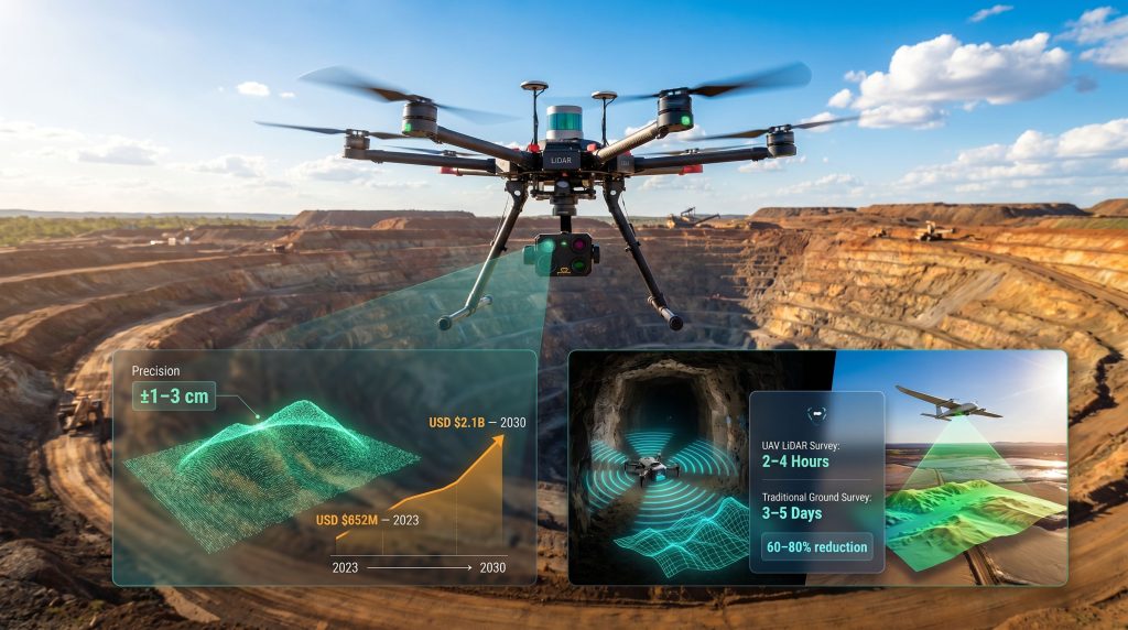
The global mining UAV market was valued at approximately USD $652 million in 2023 and is projected to exceed USD $2.1 billion by 2030, reflecting a compound annual growth rate of roughly 18 percent. That growth trajectory is not driven by novelty. It reflects a convergence of pressures that are making legacy data collection methods increasingly difficult to justify.
Three forces are acting simultaneously. First, labour markets in mining regions globally are tightening, making skilled survey crews harder to source and more expensive to retain. Second, ESG compliance obligations are intensifying scrutiny of environmental monitoring, particularly around tailings management and progressive rehabilitation tracking. Third, data-driven mining operations are demanding higher-frequency, higher-fidelity data to feed mine planning software, AI-driven reporting platforms, and autonomous haulage systems.
Against that backdrop, the adoption question is no longer whether drone technology belongs in mining operations. It is how quickly an operation can build the data infrastructure to use that technology effectively.
UAVs as an Intelligence Layer, Not Just a Survey Tool
One of the most important conceptual shifts in understanding drone technology in mining operations is recognising that the drone itself is only one component of the value chain. The aircraft captures data. The value is created by what happens to that data next.
Modern UAV programs feed into broader mine intelligence ecosystems: GIS platforms, AI-powered mining efficiency tools, ERP-integrated inventory systems, and increasingly, live digital twin models of entire mine sites. The transition being enabled is a shift from periodic data collection to continuous, high-frequency site monitoring, where decision-makers have access to near-real-time information about ground conditions, inventory levels, and infrastructure status.
Drones do not replace mine engineers. They dramatically compress the time between data collection and decision-making, enabling faster, safer, and more cost-effective operational responses across every stage of the mining value chain.
Core Applications in Surface Mining: Where Adoption Is Most Mature
Aerial Surveying and High-Precision Terrain Modelling
Photogrammetry and LiDAR sensor payloads mounted on commercial UAVs routinely achieve centimetre-level accuracy in terrain modelling. The outputs — orthophotos, Digital Surface Models, Digital Elevation Models, and 3D point clouds — provide engineering teams with spatial datasets that rival or exceed the accuracy of traditional ground surveys while being delivered in a fraction of the time. Furthermore, 3D geological modelling has become increasingly accessible to operations of all sizes as UAV capture costs decline.
The comparison between methods is stark:
| Method | Time to Complete 1 km² Survey | Accuracy | Estimated Cost |
|---|---|---|---|
| Traditional Ground Survey | 3 to 5 days | ±5 to 10 cm | High |
| Manned Aerial Survey | 1 to 2 days | ±5 cm | Very High |
| UAV Photogrammetry | 2 to 6 hours | ±1 to 3 cm | Low to Medium |
| UAV LiDAR | 2 to 4 hours | ±1 to 2 cm | Medium |
The time compression is significant. Survey data that previously required multi-day crew mobilisation, field collection, and office processing can now be available to engineers the same day the flight is conducted.
Stockpile Volume Measurement and Inventory Accuracy
Bulk commodity stockpile measurement has historically been one of the highest-error activities in mine site management. Manual estimation methods for coal, iron ore, and copper concentrate stockpiles carry error margins of 5 to 10 percent, which translates directly into inventory reconciliation failures and financial reporting inaccuracies.
Drone-based volumetric measurement consistently achieves error margins of less than 1 to 3 percent, and critically, it enables audit frequency that was previously cost-prohibitive. Where traditional methods might support monthly stockpile surveys, UAV programs enable weekly or even daily audits at marginal additional cost.
The workflow is straightforward in principle: flight planning, point cloud generation, mesh modelling, and volume output integration with ERP and inventory management systems. The practical workflow disciplines around consistent flight paths and ground control point placement are where operational rigour determines data quality.
Post-Blast Fragmentation Analysis
Blast performance directly determines downstream processing efficiency. Oversized fragmentation increases crusher wear and throughput losses. Undersized fragmentation can indicate over-drilling or excessive explosive consumption. Traditionally, fragmentation assessment was conducted manually or with ground-level photography, both methods being slow and subject to observer bias.
UAV imagery processed through AI-driven fragmentation analysis software can assess rock particle size distribution across an entire blast muck pile within hours of a shot. In addition, advances in AI in drilling and blasting are enabling real-time evaluation of blast outcomes that feeds directly back into drill-and-blast design optimisation for subsequent cycles, creating a continuous improvement loop that was previously difficult to implement systematically.
Tailings Storage Facility Monitoring: An ESG Imperative
The catastrophic tailings dam failure at Brumadinho, Brazil in 2019 fundamentally changed the regulatory and reputational landscape for tailings management globally. Over 270 lives were lost in that event, and the subsequent scrutiny from regulators, investors, and ESG rating agencies has placed tailings storage facility integrity at the top of the risk register for every major mining operator.
Drone technology in mining operations addresses this risk through continuous deformation monitoring, seepage detection from thermal imaging, and precise crest elevation tracking that can identify settlement anomalies far earlier than periodic manual inspections. When integrated with geotechnical sensor networks, UAV-derived surface data adds a spatial layer to point-based sensor readings, creating multi-layer stability assessment capability that no single monitoring method can achieve alone.
Underground Mining Applications: The Technical Frontier
Navigating GPS-Denied Environments
Surface drone operations benefit from GPS positioning for navigation and georeferencing. Underground mining removes that foundation entirely. The navigation solution for underground UAVs relies on SLAM technology — Simultaneous Localisation and Mapping — combined with LiDAR-based positioning and inertial measurement units that allow a drone to build and maintain a positional map of its environment without any external reference signal.
The operational environment underground adds further complexity. Dust concentrations that can impair sensor performance, narrow drives that constrain aircraft size, humidity that affects electronics, and potential gas hazards including methane accumulations all require purpose-built platforms rather than commercial surface UAVs adapted for underground use. Resources such as Flyability's guide to mine drones provide detailed technical context on platforms designed specifically for these conditions.
Stope and Void Mapping: Replacing Hazardous Manual Surveys
Cavity Monitoring Surveys (CMS) in underground mining have traditionally required workers or specialised scanning equipment to approach the edges of excavated stopes and voids — areas that are frequently characterised by unsupported ground, overbreak, and active rockfall risk. This is one of the highest-risk routine activities in underground operations.
SLAM-equipped drones can now generate accurate 3D models of stopes, drives, and excavated voids without any worker entering the unsupported zone. The models identify overbreak, underbreak, rock fracture patterns, and ground instability conditions that inform geotechnical decisions about support requirements and safe re-entry conditions.
In documented emergency response scenarios, SLAM-equipped UAVs deployed following partial roof collapse events have delivered complete 3D models of affected drives to geotechnical teams within hours of an incident, enabling rescue planning without additional worker exposure to unstable ground.
Hazard Detection and Emergency Response Capability
Thermal and gas-sensing payload integration extends underground drone utility into active hazard management. Methane accumulation mapping, carbon monoxide hotspot identification, and spontaneous combustion indicators can all be detected through appropriate sensor payloads on purpose-built underground platforms.
Post-blast re-entry assessment is a particularly high-value application. Current protocols require waiting periods and manual ventilation checks before workers return to a blasted area. Drone-based re-entry assessment can confirm ventilation clearance and structural integrity with objective sensor data rather than relying on manual inspection under conditions that may still carry residual hazard.
The Quantified Safety and Productivity Case
Measuring the Safety Dividend
Mining consistently ranks among the world's highest-risk industries, with fatal injury rates 4 to 7 times higher than the general workforce average across major producing nations. The substitution principle that drone technology enables is straightforward: every manual inspection replaced by a UAV flight is a measurable reduction in worker exposure hours within hazardous zones.
The tasks where this substitution has the clearest safety value include:
- Highwall face inspections in open-pit operations where rockfall risk is constant
- Tailings dam crest walks that require personnel to operate on or near dam structures
- Post-blast re-entry assessments in underground headings
- Underground void edge surveys adjacent to unsupported excavations
- Infrastructure inspections on elevated or structurally uncertain platforms
Each of these tasks, when conducted manually, generates measurable worker exposure hours in elevated-risk environments. UAV substitution does not eliminate operational risk entirely, but it concentrates human exposure to the lower-risk activities of flight planning, data processing, and analysis.
Cost Reduction Benchmarks Across the Mining Value Chain
The economic case for drone technology in mining operations is well-supported by operational data across the industry. The following table presents indicative cost benchmarks:
| Operational Activity | Traditional Cost Benchmark | UAV-Enabled Cost Reduction Estimate |
|---|---|---|
| Open-pit topographic survey (1 km²) | USD $15,000 to $25,000 | 60 to 80% reduction |
| Stockpile volume audit (per event) | USD $5,000 to $12,000 | 50 to 70% reduction |
| Tailings dam inspection (annual) | USD $30,000 to $80,000 | 40 to 65% reduction |
| Underground void mapping (per stope) | USD $8,000 to $20,000 | 50 to 75% reduction |
Note: These figures represent indicative industry benchmarks and will vary by geography, site complexity, contractor rates, and the specific sensor payloads required.
Most mining operations that have implemented structured UAV programs report payback periods of 6 to 18 months, with the fastest returns concentrated in high-frequency surveying and stockpile measurement activities where the cost differential between drone and traditional methods is largest.
The next major ASX story will hit our subscribers first
Geological Exploration: Drones as Discovery-Stage Tools
Mineral Mapping and Low-Altitude Geophysical Survey
The application of UAVs extends well upstream into exploration. Multispectral and hyperspectral sensor payloads can identify surface mineralogy indicators and hydrothermal alteration zones at a resolution and cost point previously unachievable outside of satellite imagery or manned airborne surveys.
Magnetometer-equipped UAVs conducting low-altitude aeromagnetic surveys represent one of the more technically sophisticated emerging applications. By flying at altitudes of 30 to 80 metres above ground level, UAV-borne magnetometers capture magnetic anomaly data with spatial resolution that manned aircraft surveys at 60 to 120-metre terrain clearance cannot match. For target generation in greenfield exploration programs, this resolution advantage can meaningfully differentiate prospective zones that would otherwise remain ambiguous in coarser survey data.
Environmental Baseline and Rehabilitation Monitoring
Progressive mine rehabilitation has traditionally been monitored through periodic ground-based vegetation surveys, a labour-intensive process with inherent spatial sampling limitations. LiDAR canopy modelling from UAV platforms enables quantitative biomass estimation across rehabilitated landforms, supporting both regulatory compliance reporting and carbon accounting for ESG disclosure frameworks.
Pre-mining environmental baseline surveys using drone technology establish georeferenced records of vegetation cover, hydrology patterns, and terrain conditions that become the reference standard against which post-mining rehabilitation performance is measured. The spatial completeness of drone-derived baseline data is substantially superior to ground transect methodologies. Furthermore, sensor-based ore sorting is another area where advanced data capture is improving resource utilisation across the mining value chain.
Key Challenges That Mining Operators Must Understand
Technical Constraints Shaping Operational Design
No technology adoption discussion is complete without an honest account of the limitations. For drone technology in mining operations, the constraints that most directly affect operational planning are:
- Battery endurance: most commercial multi-rotor platforms operate for 30 to 60 minutes per charge, requiring careful mission planning on large open-pit sites and multiple battery rotations or recharging cycles
- Payload weight trade-offs: heavier sensor payloads such as LiDAR units and hyperspectral cameras reduce flight endurance and operational flexibility, forcing operators to prioritise sensor selection against coverage requirements
- Data processing infrastructure: large photogrammetry and point cloud datasets require significant computing resources and specialist processing skills that are not universally available within mining operations
- SLAM system costs: GPS-denied underground platforms with full SLAM navigation capability carry significant cost premiums over standard surface UAV platforms
Regulatory Complexity: The BVLOS Barrier
Beyond Visual Line of Sight operations represent the operational mode that unlocks the full productivity potential of drone technology across large mine sites. Flying beyond the pilot's visual range allows a single operator to cover far greater areas without repositioning, which is transformative for survey economics on major open-pit operations.
Regulatory Note: Mining operators deploying UAVs must ensure compliance with national aviation authority regulations governing BVLOS operations. These include CASA frameworks in Australia, FAA Part 107 provisions in the United States, and EASA regulations in Europe. BVLOS approvals currently remain one of the primary operational barriers to full-scale autonomous drone deployment in mining environments.
The regulatory maturity gap between jurisdictions is a genuine operational consideration for multinational mining companies. Australia, Canada, and parts of Europe have relatively developed UAV regulatory frameworks. However, many emerging market mining jurisdictions have limited or nascent UAV-specific regulatory structures, creating both uncertainty and potential first-mover advantages for operators willing to engage early with local aviation authorities. For a comprehensive overview of compliance requirements, AVLAW's guide to drones in mining provides detailed jurisdiction-specific guidance.
The Next Generation of Mining UAV Technology
Autonomous Systems and AI-Integrated Onboard Processing
The current generation of mining UAVs requires skilled pilots to execute flight plans, even where those plans are pre-programmed. The next generation of autonomous systems integrates AI-powered obstacle avoidance, adaptive path planning, and critically, onboard real-time anomaly detection that processes sensor data during the flight rather than after it.
This shift from post-flight processing to in-flight intelligence reduces the time between data capture and actionable output from hours to minutes. For safety-critical applications such as TSF monitoring and underground hazard detection, that latency reduction has direct operational significance.
Swarm drone technology — where multiple coordinated UAVs cover different zones of a large open-pit mine simultaneously — is transitioning from research settings into early commercial deployment. The productivity multiplier from coordinated multi-aircraft operations fundamentally changes the economic calculus for survey programs on operations covering tens of square kilometres.
Hydrogen Propulsion and Extended Endurance Platforms
Hydrogen fuel cell UAVs offer 2 to 4 times the flight endurance of lithium battery equivalents at equivalent payload capacity. For large-scale open-pit operations where battery limitations currently necessitate multiple flights, crew repositioning, and recharging cycles, extended endurance platforms materially reduce the operational complexity and cost of comprehensive site surveys.
The maturation timeline for commercial hydrogen UAV platforms in industrial applications is actively compressing as fuel cell costs decline and the airframe engineering knowledge base grows.
Digital Twin Integration: The Convergence Point
The most strategically significant near-term development in drone technology for mining operations is not hardware improvement. It is the integration of continuous UAV data feeds into live digital twin models of mine sites.
A digital twin updated through regular drone surveys and sensor network feeds creates a continuously accurate virtual representation of the physical mine. Integrated with autonomous haulage systems, remote operations centres, and predictive maintenance platforms, this capability enables mine management decisions to be made on the basis of current ground truth rather than data that is days or weeks old.
The next competitive frontier in mining UAV technology is not the drone platform itself. It is the speed and intelligence of the data pipeline connecting aerial capture to actionable mine management decisions.
Practical Roadmap for Mining Operators Evaluating UAV Adoption
For operations at early stages of UAV program development, a structured evaluation approach reduces the risk of misaligned investment:
- Audit current data collection workflows to identify the highest-cost and highest-risk manual activities where UAV substitution would deliver the greatest immediate return
- Define the primary use case clearly before selecting hardware; the platform requirements for open-pit surveying differ substantially from underground void mapping or exploration magnetometry
- Evaluate the build-versus-buy decision honestly, recognising that in-house capability requires investment in training, licensing, data processing infrastructure, and regulatory compliance, while UAV-as-a-service providers offer faster deployment with lower capital commitment
- Engage aviation regulatory authorities early to understand the approval pathway for BVLOS operations, which are likely to be required for full-scale productivity benefits on large sites
- Invest in data infrastructure in parallel with hardware, recognising that processing pipelines, software integration, and analyst capability determine whether the data collected becomes actionable intelligence or simply accumulates in storage
- Establish clear KPIs for program performance including cost per survey, data turnaround time, inspection frequency achieved versus target, and incident reduction metrics in hazardous zones
Frequently Asked Questions About Drone Technology in Mining Operations
What drone types are most commonly deployed in surface mining?
Fixed-wing UAVs are preferred for large-area surveying due to their endurance and coverage efficiency. Multi-rotor platforms dominate inspection applications where hover capability and precise positioning around infrastructure are required. Hybrid VTOL (vertical take-off and landing) platforms that combine fixed-wing cruise efficiency with multi-rotor flexibility are gaining traction for operations that need to handle both use cases from a single platform.
How accurate are drone surveys compared to traditional ground methods?
UAV photogrammetry and LiDAR systems routinely achieve ±1 to 3 cm horizontal accuracy under optimal conditions with properly placed ground control points. This is comparable to or exceeds the accuracy of traditional ground survey methods for most mining engineering applications, while being delivered in a fraction of the time and at significantly lower cost.
Can drones be used effectively in underground mines?
Yes, but specifically designed platforms are required. SLAM-based navigation and LiDAR positioning systems allow underground drones to operate without GPS by building their own spatial reference map in real time. These systems carry higher costs than standard surface platforms and require operational protocols adapted to confined, dusty, and potentially gas-affected environments.
What regulations govern mining drone operations?
Operations are governed by national aviation authorities including CASA in Australia, the FAA under Part 107 provisions in the United States, and EASA in Europe. Beyond Visual Line of Sight operations, which are critical for large-scale mining productivity benefits, require specific approvals under all major regulatory frameworks and represent the primary regulatory constraint on autonomous deployment at scale.
Are drones replacing professional surveyors and geologists in mining?
No. Drone technology accelerates data collection and expands the frequency and spatial coverage of site intelligence. The interpretation, analysis, and decision-making functions of surveyors, geologists, and geotechnical engineers remain essential and are in many respects enhanced by access to higher-quality, more frequent data. The professional role shifts from fieldwork execution toward data analysis and strategic interpretation.
The Strategic Imperative: Building UAV Capability Before the Gap Widens
The mining operations that have moved earliest and most systematically into drone technology are accumulating compounding advantages. Survey data quality improves as flight programs mature and ground control networks are refined. Operational teams develop institutional knowledge of data interpretation. Integration with mine planning and ERP systems deepens.
Critically, the safety culture shift that accompanies the substitution of manual high-risk inspections with drone operations becomes embedded in standard practice. The gap between early adopters and operations still relying predominantly on traditional methods is widening as the technology matures.
The economics that made UAV programs cost-justified only for large-scale operations five years ago now extend to mid-tier and smaller operations as hardware costs decline and UAV-as-a-service models proliferate. Consequently, drone technology in mining operations has moved decisively from the innovation pilot phase into standard operational infrastructure at leading mining companies globally.
The question for operators who have not yet built this capability is not whether the investment is justified. It is how much operational, safety, and competitive ground they can afford to continue ceding while they delay.
Readers seeking to expand their knowledge of UAV applications in industrial and mining contexts are encouraged to explore resources available through the Australian Mine Safety Journal, the Society for Mining, Metallurgy and Exploration, and specialist UAV industry publications covering operational case studies and evolving regulatory frameworks.
Want to Identify ASX Mining Companies Leading the Drone Technology Revolution?
Discovery Alert's proprietary Discovery IQ model scans ASX announcements in real time, instantly alerting subscribers to significant mineral discoveries made by the exploration and mining companies embracing these data-driven operational advantages — explore historic examples of major discovery returns to understand the scale of opportunity, then begin a 14-day free trial at Discovery Alert to position yourself ahead of the broader market.