June 27, 2026
Underground environments present unique technological challenges that have revolutionised how mining operations approach safety, data collection, and operational efficiency. Drones in underground mining represent a fundamental shift in subterranean extraction operations, extending far beyond surface-level innovations. These cutting-edge aerial platforms must operate in conditions that traditional equipment simply cannot handle, creating new possibilities for industry evolution trends within the most challenging industrial environments.
Modern underground mining facilities eliminate conventional positioning technology, demanding sophisticated autonomous systems capable of centimetre-level accuracy in completely enclosed spaces. The absence of GPS signals, combined with confined spaces, dust, moisture, and variable lighting conditions, creates environments where conventional drone technology fails completely. However, recent advances in autonomous navigation and specialised hardware design have opened entirely new possibilities for data-driven mining operations.
GPS-Denied Navigation Technologies Reshaping Underground Operations
Underground mining environments eliminate the fundamental positioning technology that most aerial systems rely upon. Furthermore, without satellite connectivity, drones in underground mining must employ alternative navigation methods through environmental feature detection and mapping. Simultaneous Localisation and Mapping (SLAM) technology has emerged as the primary solution, enabling real-time position tracking in previously inaccessible spaces.
Visual-inertial odometry combines multiple sensor inputs to create continuous position estimates. Inertial Measurement Units track acceleration and rotation across three axes, whilst visual sensors analyse feature movement between consecutive frames. This multi-sensor approach provides redundancy that ensures navigation reliability even when individual sensors encounter challenging conditions.
LiDAR-based navigation systems offer additional positioning accuracy by creating detailed point cloud maps of tunnel walls and infrastructure. These active sensing systems generate their own illumination, making them independent of ambient lighting conditions that often challenge visual navigation methods. Consequently, the combination of these technologies creates navigation systems capable of maintaining position accuracy within confined underground spaces for extended periods.
Collision-avoidance systems specifically designed for underground environments incorporate ultrasonic sensors, proximity detection, and real-time obstacle mapping. However, these systems must react faster than surface-based equivalents due to the confined nature of tunnel environments where recovery space is minimal.
When big ASX news breaks, our subscribers know first
Specialised Hardware Engineering for Subterranean Environments
Underground drone platforms require fundamental hardware redesigns that go far beyond simple modifications of surface equipment. In addition, collision-tolerant frame designs incorporate protective caging systems that allow continued operation after wall impacts. These protective structures must balance collision protection with aerodynamic efficiency and sensor accessibility.
Current underground platforms measure approximately 60 x 60 centimetres, representing a carefully engineered balance between payload capacity and manoeuvrability in confined spaces. This compact form factor enables operation in ventilation shafts, maintenance tunnels, and other restricted areas where larger equipment cannot access.
Enhanced sensor packages integrate multiple data collection modalities within weight and power constraints. For instance, modern platforms combine 4K visual cameras, thermal imaging systems, LiDAR mapping capabilities, and specialised sensors like ultrasonic thickness measurement devices. This multi-sensor approach enables comprehensive data collection during single flights, maximising operational efficiency.
Modular payload architectures allow mission-specific configurations without requiring complete aircraft replacement. Operators can switch between survey-focused configurations with high-resolution LiDAR and inspection-focused setups emphasising thermal and visual analysis. Recent developments include ultrasonic thickness measurement payloads that provide precise material assessment capabilities localised within LiDAR point clouds.
Battery management systems for underground operations must handle temperature variations, moisture exposure, and extended flight times without GPS-assisted return-to-base functionality. These systems incorporate thermal monitoring and power optimisation algorithms specifically designed for underground operational profiles.
Revolutionary Applications Transforming Underground Mining Operations
Advanced Tunnel and Shaft Surveying Capabilities
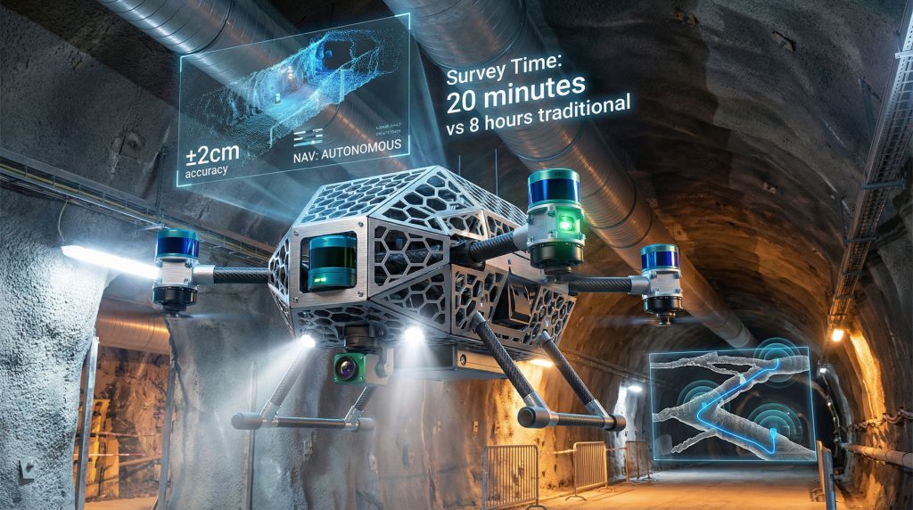
Underground surveying operations have experienced dramatic efficiency improvements through drone-based data collection systems. Traditional manual surveys requiring 6-8 hours can now be completed in 15-20 minutes using autonomous aerial platforms. Furthermore, shaft inspections that previously demanded 4-6 hours of manual work are now accomplished in 10-15 minutes with enhanced accuracy and safety.
The following demonstrates the operational efficiency gains across different survey applications:
| Survey Method | Traditional Time | Drone-Assisted Time | Accuracy Level |
|---|---|---|---|
| Manual Tunnel Survey | 6-8 hours | 15-20 minutes | ±5cm |
| Shaft Inspection | 4-6 hours | 10-15 minutes | ±2cm |
| Stockpile Volume | 2-3 hours | 8-12 minutes | ±1cm |
Note: These operational timeframes represent typical industry applications. Actual performance may vary based on specific tunnel dimensions, environmental conditions, and required survey resolution.
Three-dimensional mapping capabilities generate comprehensive point clouds that integrate seamlessly with mine planning software systems. Moreover, 3D geological modelling creates detailed spatial models with centimetre-level accuracy, enabling precise volumetric calculations and structural analysis. These digital models support advanced mine planning, equipment placement optimisation, and safety zone identification.
Real-time data correlation allows operators to identify defects and structural issues during flight operations rather than through post-processing analysis. By combining visual inspection data with precise LiDAR positioning, inspectors can locate specific problems within millimetre-accurate spatial coordinates.
Infrastructure Inspection and Monitoring Systems
Ventilation system assessments represent critical safety applications where drone technology provides unprecedented access and analysis capabilities. Thermal imaging reveals airflow patterns, temperature distributions, and equipment performance indicators that manual inspection cannot detect. These assessments identify ventilation inefficiencies, blocked airways, and equipment malfunctions before they compromise worker safety.
Structural integrity evaluations utilise LiDAR scanning to detect wall deformation, crack development, and support structure displacement over time. Comparative analysis between successive surveys reveals structural changes at their earliest stages, enabling preventive maintenance before critical failures occur.
Equipment condition monitoring in hazardous zones eliminates human exposure whilst providing detailed thermal and visual analysis. Bearing temperature monitoring, seal integrity assessment, and mechanical wear detection through thermal signatures enable predictive maintenance programmes that reduce equipment downtime and safety risks.
Multi-sensor integration enables comprehensive infrastructure assessment during single survey flights. Visual cameras document surface conditions, thermal sensors identify temperature anomalies, and LiDAR provides precise dimensional analysis. This integrated approach maximises data collection efficiency whilst minimising operational disruption.
Emergency Response and Search Operations
Emergency response applications leverage thermal imaging capabilities to locate personnel in post-incident scenarios where visibility is compromised. Human body heat signatures remain detectable through smoke, dust, or darkness, providing critical information for rescue operations. Additionally, rapid deployment capabilities enable immediate assessment without waiting for ventilation clearing or manual access preparation.
Critical Safety Application: Underground drones eliminate up to 80% of high-risk manual inspections, significantly reducing worker exposure to unstable geological conditions and equipment hazards during emergency response operations.
Gas detection sensors integrated with emergency response platforms provide real-time atmospheric analysis identifying hazardous concentrations of carbon monoxide, methane, hydrogen sulfide, and oxygen depletion. This information guides emergency response teams in establishing safe entry procedures and evacuation routes.
Autonomous navigation capabilities ensure drone recovery even when communication with surface control is compromised. Return-to-base functionality operates independently of operator commands, preventing asset loss during emergency scenarios and maintaining operational capability for extended response efforts.
Collapsed area assessment through LiDAR mapping provides three-dimensional analysis of debris patterns, structural stability, and potential access routes. This information supports rescue planning and equipment deployment decisions without requiring initial human entry into unstable areas.
Advanced Technical Solutions for Underground Challenges
Multi-Sensor Navigation Architecture
Modern underground navigation systems employ sophisticated sensor fusion algorithms that combine inertial measurement data, visual odometry, and LiDAR positioning. Extended Kalman filtering and particle filtering techniques merge these diverse data streams to maintain continuous position estimates with drift correction capabilities.
Visual-inertial navigation algorithms track distinctive features between consecutive camera frames whilst compensating for camera motion through IMU data. This approach provides positioning accuracy in well-lit areas whilst maintaining operation capability during lighting transitions or complete darkness when combined with active LiDAR illumination.
Loop closure detection algorithms recognise when drones in underground mining revisit previously mapped areas, enabling correction of cumulative navigation errors. This capability is particularly valuable during extended survey missions where small positioning errors could accumulate into significant location uncertainty without corrective feedback.
Multi-sensor fusion hierarchies prioritise different navigation inputs based on environmental conditions. In well-lit areas with distinctive visual features, camera-based odometry may provide primary positioning data. However, in dark or featureless tunnels, LiDAR odometry becomes the primary navigation source, with IMU data providing continuous motion tracking between sensor updates.
Environmental Adaptation and Protection Systems
Underground mining environments subject equipment to extreme dust, moisture, temperature variations, and corrosive atmospheric conditions. Specialised protective systems ensure reliable operation across these challenging environmental parameters. Conformal coating on circuit boards protects against moisture and corrosive gases, whilst sealed connectors prevent dust and water ingress into critical electronic systems.
Temperature management systems accommodate the significant thermal variations encountered in underground operations. Battery performance optimisation algorithms adjust power delivery based on ambient temperature conditions, maintaining flight capabilities across the operational temperature range. Thermal monitoring prevents equipment damage from overheating during intensive sensor operation periods.
Dust protection systems incorporate sealed motor designs and filtered ventilation for electronics cooling. Brushless motor configurations minimise particle ingress whilst maintaining propulsion efficiency in dense underground atmospheres. Sensor protection includes sealed housings for cameras and electronic systems whilst maintaining optical clarity for LiDAR and imaging functions.
Low-light and thermal imaging capabilities enable operation in complete darkness without artificial illumination requirements. Thermal sensors operate independently of visible light conditions, whilst LiDAR systems provide active illumination for navigation and mapping functions. This multi-spectral approach ensures operational capability regardless of underground lighting conditions.
Integrated Data Processing and Communication Networks
Real-time data processing capabilities enable immediate analysis and decision-making during flight operations. Edge computing systems onboard the aircraft perform initial data correlation between visual, thermal, and LiDAR sensors, reducing raw data transmission requirements and enabling faster operator feedback.
Wireless communication protocols maintain continuous connectivity with surface control systems through fibre optic tethers or RF transmission systems. Data compression algorithms optimise transmission efficiency whilst preserving critical information quality for immediate operational decisions.
Offline operation capabilities with post-flight data synchronisation enable extended missions in areas where continuous communication is not feasible. Autonomous flight path execution and data collection continue even when communication links are temporarily interrupted, with full data transfer occurring upon return to communication range.
Custom processing software correlates multi-sensor data streams to provide integrated analysis capabilities. Visual defect identification algorithms compare current inspections with baseline surveys to identify changes over time. Thermal analysis software identifies equipment anomalies and trending issues that indicate developing maintenance requirements.
Operational Benefits and Economic Impact
Personnel Safety Enhancement
Underground drone deployment eliminates human exposure to unstable geological conditions, equipment hazards, and atmospheric contamination. Remote inspection capabilities allow assessment of potentially dangerous areas without putting personnel at risk. This safety improvement is particularly significant in post-incident scenarios where structural integrity may be compromised.
Confined space entry requirements are substantially reduced through comprehensive external assessment capabilities. Traditional inspection procedures requiring specialised safety equipment, atmospheric monitoring, and emergency response preparation can often be replaced with drone-based assessment that provides equivalent or superior data quality.
Hazardous equipment inspection through thermal and visual analysis identifies developing problems before they create safety risks for maintenance personnel. Early detection of bearing failures, seal degradation, and structural issues enables proactive maintenance that prevents equipment failures during occupied work periods.
Operational Efficiency and Cost Reduction
The following analysis demonstrates cost-benefit improvements across major underground inspection applications:
| Operation Type | Traditional Cost | Drone-Assisted Cost | Savings Percentage |
|---|---|---|---|
| Tunnel Survey | $5,000-8,000 | $1,500-2,500 | 65-70% |
| Equipment Inspection | $3,000-5,000 | $800-1,200 | 75-80% |
| Emergency Assessment | $10,000-15,000 | $2,000-3,500 | 70-80% |
Disclaimer: Cost figures represent typical industry applications and may vary based on specific operational conditions, equipment requirements, and local labour costs. Actual savings depend on implementation approach and existing operational procedures.
Faster data collection cycles enable more frequent monitoring and assessment programmes without proportional increases in operational costs. Equipment that previously required monthly or quarterly inspection due to time and cost constraints can now be monitored weekly or even daily using automated drone surveys.
Enhanced decision-making through detailed three-dimensional models and comprehensive sensor data improves maintenance scheduling, equipment replacement planning, and operational optimisation. Precise volumetric data supports more accurate resource planning and extraction optimisation.
Reduced equipment downtime for inspection procedures allows continuous operation during survey and monitoring activities. Traditional inspection methods often require equipment shutdown and area evacuation, whilst drone-based inspection can proceed during normal operations in many cases.
Leading Technologies and Implementation Strategies
Advanced Sensor Integration Platforms
LiDAR-equipped survey systems provide high-precision three-dimensional scanning capabilities with real-time point cloud generation. Modern platforms integrate FARO-designed LiDAR payloads that deliver centimetre-accurate measurements suitable for engineering-grade survey applications. Point cloud data formats maintain compatibility with standard mine planning software systems, enabling seamless integration with existing workflows.
Multi-sensor inspection platforms combine visual, thermal, ultrasonic, and chemical detection capabilities within single aircraft configurations. Recent developments include ultrasonic thickness measurement systems that correlate material assessment data with precise LiDAR positioning, enabling detailed structural analysis with spatial accuracy.
Autonomous navigation platforms execute pre-programmed flight paths with obstacle detection and avoidance capabilities. Return-to-base functionality ensures aircraft recovery even during communication failures, whilst adaptive path planning algorithms adjust routes based on real-time environmental conditions.
Gas detection and atmospheric monitoring sensors provide real-time analysis of oxygen levels, explosive gas concentrations, and toxic substance detection. These capabilities support both routine safety monitoring and emergency response applications where atmospheric conditions may prevent human access.
Strategic Implementation Approaches
Pilot programme development begins with comprehensive risk assessment and safety protocol establishment. Initial deployment focuses on low-risk applications that demonstrate capability whilst building operational experience and confidence. Operator training and certification programmes ensure safe and effective technology utilisation across different underground environments.
Integration with existing mine management systems requires careful planning to ensure data compatibility and workflow optimisation. Point cloud integration with CAD software, thermal analysis correlation with maintenance management systems, and survey data integration with mine planning applications maximise operational value.
Scalability considerations address fleet management requirements for operations across multiple underground sites. Standardised data collection protocols, centralised data processing capabilities, and coordinated maintenance programmes enable efficient expansion of drone operations across larger mining organisations.
Regulatory compliance frameworks address underground aviation safety standards, data privacy requirements, and environmental impact considerations. Coordination with mine safety authorities ensures proper integration with existing safety protocols and emergency response procedures.
The next major ASX story will hit our subscribers first
Future Developments and Industry Evolution
Emerging Technology Integration
Artificial intelligence integration for automated defect detection represents the next evolution in underground drone capabilities. Machine learning algorithms trained on extensive inspection databases can identify developing structural issues, equipment anomalies, and safety hazards with minimal human interpretation requirements. Furthermore, AI in mining processes continues to advance automation across all underground operations.
Swarm robotics applications enable coordinated operations using multiple aircraft simultaneously. This approach allows rapid survey of large underground areas, redundant data collection for critical inspections, and distributed sensor networks for comprehensive environmental monitoring.
Enhanced battery technology developments focus on extended flight times and improved performance under underground environmental conditions. Solid-state battery systems and advanced energy density improvements will enable longer survey missions and reduced battery replacement frequency.
Digital twin integration creates dynamic underground mine models that incorporate real-time drone survey data. These comprehensive digital representations support predictive maintenance, operational optimisation, and safety analysis through continuous data integration from automated drone surveys.
Industry Adoption Trends and Challenges
Expansion from major mining companies to mid-tier operations reflects improving cost-effectiveness and technology accessibility. Standardisation of operational procedures and training programmes reduces implementation barriers for smaller organisations with limited technical resources.
Industry-specific software development provides specialised analysis tools for underground mining applications. Custom processing algorithms for geological analysis, structural assessment, and equipment monitoring maximise the value of drone-collected data for mining-specific decisions.
Standardisation of underground drone protocols across the industry will improve safety, reduce training requirements, and enable equipment interoperability. Industry associations and regulatory bodies are developing guidelines for safe operation, data sharing, and emergency procedures.
Training and workforce development programmes address the need for skilled operators and data analysts capable of maximising drone technology benefits. Integration with existing mining education programmes and professional development initiatives ensures adequate human resources for technology adoption.
Investment requirements for comprehensive technology adoption include aircraft acquisition, training programmes, data processing infrastructure, and integration with existing systems. However, rapid payback periods through operational savings and safety improvements support business case development for most underground operations.
The transformation of underground mining through autonomous aerial technology represents more than incremental improvement in existing processes. These sophisticated platforms enable entirely new approaches to safety management, operational efficiency, and data-driven decision making in the world's most challenging industrial environments. Moreover, these engineering marvels underground demonstrate how advanced technology can revolutionise traditional operations. As technology continues advancing and costs decrease, comprehensive adoption of drones in underground mining operations will become standard practice rather than competitive advantage, fundamentally reshaping how the industry approaches subterranean resource extraction. Additionally, emerging underground mining technologies continue to expand the possibilities for safer and more efficient operations in these challenging environments.
Searching for the Next Revolutionary Mining Technology Investment?
Discovery Alert's proprietary Discovery IQ model delivers instant alerts on breakthrough mining technology announcements across the ASX, helping investors identify companies pioneering innovations like advanced underground drone systems before the broader market recognises their potential. Discover how major mining technology breakthroughs have generated exceptional returns and begin your 30-day free trial today to position yourself ahead of the next wave of mining innovation.