June 19, 2026
The Geological Intelligence Gap Holding Back One of Africa's Most Promising Mining Frontiers
Consider what happens when a country possesses extraordinary geological wealth but lacks the data infrastructure to prove it exists. Investors apply maximum risk premiums. Exploration timelines stretch by years. Capital flows toward jurisdictions where the subsurface is already well understood, even if those regions offer lower geological upside. This is precisely the dynamic that has constrained Egypt's mining sector for the better part of four decades, and it is the dynamic that the country's new Egypt aerial mining survey is designed to permanently disrupt.
The mechanics of geological underinvestment are self-reinforcing. Without modern survey data, exploration companies cannot prioritise targets efficiently. Without efficient target prioritisation, early-stage costs balloon. Without cost-competitive exploration economics, fewer companies enter the market. And without a competitive exploration market, the national geological database never gets updated. Egypt has been caught in exactly this cycle since its last comprehensive airborne geophysical program was completed in 1984.
When big ASX news breaks, our subscribers know first
Why Egypt's Mining Sector Has Punched Far Below Its Geological Weight
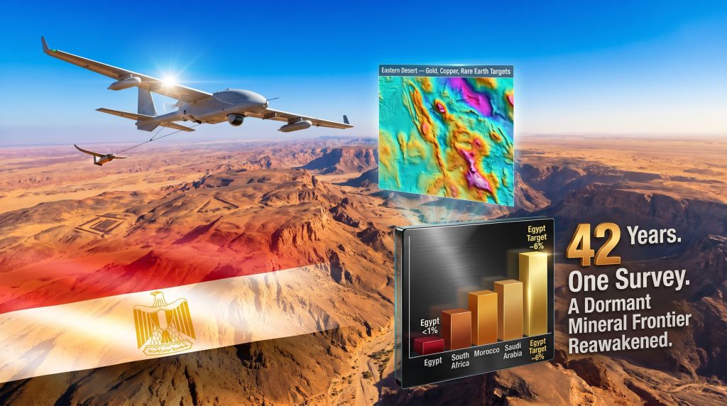
Egypt occupies a geologically privileged position. The country sits atop portions of the Arabian-Nubian Shield, one of the planet's most significant Precambrian geological terranes, and its territory spans sedimentary basins, metamorphic belts, and structurally complex volcanic sequences that together represent an extraordinary diversity of mineral potential. Yet despite this endowment, mining contributes less than 1% of Egypt's national GDP, a figure that represents one of the most striking mismatches between geological prospectivity and economic output anywhere in the developing world.
The comparison across peer economies makes this gap even more visible:
| Country | Mining as % of GDP (Est.) | Primary Commodities |
|---|---|---|
| Egypt (current) | <1% | Gold, phosphate, iron ore |
| South Africa | ~8% | Gold, platinum, coal |
| Morocco | ~4% | Phosphate, silver |
| Saudi Arabia | ~3% | Gold, copper, bauxite |
| Egypt (target) | ~6% | Diversified minerals |
The structural barriers that have perpetuated this underperformance are well documented. Outdated subsurface mapping created high perceived exploration risk. Historically restrictive joint-venture requirements made Egypt less competitive relative to African peers. And the compounding absence of modern geophysical data meant that every exploration dollar spent in Egypt required more baseline work than equivalent programs in better-mapped jurisdictions.
Approximately six years ago, Egypt took meaningful steps to address the regulatory dimension of this problem, introducing reforms that reduced fiscal levies and eliminated the mandatory government joint-venture requirement that had long deterred foreign capital. However, regulatory reform alone cannot fully unlock a mining sector when the geological intelligence layer remains frozen in 1984. The aerial survey program announced in May 2026 represents the second and arguably more technically complex half of this reform architecture.
A 42-Year Data Void and What It Actually Means for Exploration Risk
The phrase "42-year gap" understates the true scale of the technological divergence between Egypt's existing geophysical dataset and current global standards. The 1984 survey was conducted using aeromagnetic technology that operated at detection sensitivities orders of magnitude below what modern sensor platforms routinely achieve. Data processing at the time required months of manual computation. Coverage was sparser, flight altitudes were higher, and the resulting maps lacked the resolution needed to distinguish between geological noise and economically significant mineral anomalies.
Furthermore, the mineral exploration importance of high-resolution geophysical data cannot be overstated in today's competitive global investment environment.
"Geological data is not static infrastructure. It depreciates in strategic value as exploration technologies advance. A dataset from 1984 does not simply represent older information; it represents a fundamentally different era of detection capability, one that was incapable of identifying the subtle geophysical signatures that modern systems routinely resolve into drillable targets."
For investors, this matters because geological uncertainty is directly priced into exploration risk premiums. Higher uncertainty means higher discount rates applied to Egyptian mineral assets, longer assumed timelines to discovery, and greater capital requirements before any resource can be defined. A modern, high-resolution national geophysical database compresses all three of these risk dimensions simultaneously.
How an Aerial Geophysical Survey Actually Works
Understanding why the Egypt aerial mining survey matters requires a basic grasp of what airborne geophysical surveying actually does and why it is so much more powerful than traditional ground-based exploration methods.
Aircraft-mounted sensor arrays measure subtle variations in the Earth's physical fields across large land areas. These variations, when interpreted against known geological relationships, reveal subsurface structures and mineral concentrations that would otherwise require years of expensive ground work to identify. The four primary measurement systems used in modern surveys are:
- Magnetic gradiometry: Detects variations in the Earth's magnetic field caused by iron-bearing minerals and structural geology, mapping faults, intrusions, and magnetite-bearing ore systems
- Electromagnetic (EM) systems: Identifies electrically conductive ore bodies including copper sulphides, gold-bearing sulphides, and base metal deposits by measuring how subsurface materials respond to induced electromagnetic fields
- Radiometric spectrometry: Maps the surface distribution of uranium, thorium, and potassium, providing insight into lithological boundaries and alteration zones associated with mineralisation
- Gravity gradiometry: Reveals density contrasts in the subsurface linked to the presence of dense ore bodies or low-density voids, complementing magnetic data in complex geological settings
From Raw Data to Investment-Grade Geological Intelligence: The Six-Stage Process
-
Flight planning: Survey corridors, line spacing, and altitude parameters are defined based on target depth, terrain characteristics, and the specific mineral systems being sought. Tighter line spacing produces higher resolution but increases survey cost and time.
-
Data acquisition: Aircraft fly systematic grid patterns, recording continuous measurements across all sensor systems simultaneously. Modern platforms can cover tens of thousands of square kilometres in a single survey campaign.
-
Data processing: Raw sensor readings are corrected for diurnal magnetic variations, terrain effects, and instrument drift, then transformed into interpretable anomaly maps using computational algorithms that would have been impossible to run in 1984.
-
Geological interpretation: Geoscientists overlay the processed geophysical anomalies with existing surface geology maps, satellite imagery, and historical exploration data to identify priority target zones.
-
Database integration: Processed results are compiled into a national geological information system, structured to be compatible with modern GIS platforms and 3D geological modelling software.
-
Target ranking: Identified anomalies are classified by inferred commodity type, estimated size, depth, and accessibility, producing a tiered exploration target list that investors can use to allocate drilling capital efficiently.
This workflow transforms speculative ground exploration into data-driven target selection, fundamentally compressing the timeline and cost of early-stage mineral discovery.
Egypt's Three Survey Regions: Different Geologies, Different Opportunities
The survey being conducted by Xcalibur Smart Mapping, in partnership with local operator Drone Tech and Egypt's Nuclear Materials Authority, covers three geologically distinct regions, each presenting a different investment profile.
The Eastern Desert: Arabia-Nubian Shield Gold Country
The Eastern Desert represents Egypt's highest-priority gold exploration province. It forms the northern extension of the Arabian-Nubian Shield, a vast Precambrian geological terrane that has produced significant gold discoveries across Saudi Arabia, Sudan, and Eritrea. Egypt's pharaonic civilisation drew heavily on Eastern Desert gold resources, with ancient mining workings scattered across the region representing some of the oldest recorded industrial activity in human history.
What is less widely understood is that modern exploration has barely tested the deeper, structurally controlled gold systems that likely underpin the ancient workings. The 1984 survey data was insufficient to map the structural architecture of these systems at the resolution needed to identify their full extent. A key speculative but geologically grounded hypothesis is that several of the Eastern Desert's known gold occurrences represent surface expressions of much larger orogenic gold systems at depth, similar to those found in equivalent shield terranes elsewhere in Africa.
Beyond gold, the Eastern Desert also hosts copper, zinc, manganese, and potentially rare earth element mineralisation associated with alkaline intrusive complexes. Indeed, the surging critical minerals demand globally makes these additional commodity targets increasingly significant for potential investors.
The Western Desert: Underappreciated Sedimentary Mineral Potential
The Western Desert has historically been explored almost exclusively for hydrocarbons, leaving its mineral potential largely uncharacterised. The region is dominated by Cretaceous and Tertiary sedimentary sequences that are prospective for phosphate, iron ore, and potentially evaporite-hosted mineral systems including potash and gypsum-associated mineralisation.
A practical advantage of the Western Desert that receives insufficient attention is its logistical accessibility. Proximity to Mediterranean port infrastructure means that any mineral deposits discovered in the northern Western Desert would face significantly lower transport costs than equivalent discoveries in more remote African mining jurisdictions.
The Sinai Peninsula: Polymetallic Complexity at a Tectonic Junction
Sinai occupies a structurally unique position at the intersection of the African and Arabian tectonic plates, creating geological complexity that is genuinely difficult to characterise without high-resolution geophysical data. Turquoise and copper mining in Sinai has been documented back to at least 3,000 BCE, indicating that mineralising processes have been active in the region across deep geological time.
The survey challenge in Sinai is more operationally complex than in the desert regions. Rugged terrain and altitude variations require specialised low-altitude flight operations to maintain the survey line spacing needed for adequate resolution.
Benchmarking the Initiative: What Global Precedents Reveal
Egypt's initiative follows a well-established pattern of national airborne survey programs that have unlocked major exploration cycles in other jurisdictions. The comparison record is instructive:
| Country | Program | Area Covered | Key Outcomes |
|---|---|---|---|
| Australia | NGSA Airborne Surveys | Ongoing, multi-decade | Multiple major gold, nickel, and lithium discoveries |
| Canada | GEM Program | Northern territories | Reduced Arctic exploration risk premiums significantly |
| Saudi Arabia | Arabian Shield Mapping | ~600,000 km² | Enabled over $1 billion in subsequent mining investment |
| Egypt (2026) | Comprehensive National Survey | Eastern/Western Desert + Sinai | Target: mining sector to ~6% of GDP |
The Saudi Arabian precedent is particularly relevant. The systematic Arabian Shield mapping conducted in collaboration with the USGS during the 1970s and 1980s created the geological intelligence foundation that enabled decades of subsequent mineral investment in the Kingdom. Egypt, which shares the same shield geology in its Eastern Desert, is effectively undertaking an analogous program now, with the advantage of technologies that are vastly more capable than those available to the Saudi-USGS partnership.
Moreover, Saudi exploration licences have demonstrated how structured geological data releases can catalyse rapid investment cycles, a precedent Egypt will be closely watching as it prepares to release its own survey results.
"The critical insight from comparative jurisdictions is that national geophysical survey programs do not just inform exploration; they restructure the competitive dynamics of an entire mineral investment market by reducing the information asymmetry between national geological authorities and international investors."
The Three-Party Partnership Structure and Why It Matters
The institutional architecture of the survey is worth examining closely. Xcalibur Smart Mapping brings international airborne geophysics expertise and advanced sensor platform capabilities developed across multiple global survey campaigns. Drone Tech provides local operational capacity, regulatory navigation, and logistical infrastructure essential for executing a complex airborne program across diverse Egyptian terrain. Egypt's Nuclear Materials Authority contributes scientific oversight and ensures integration with existing national geological records.
This three-party model is increasingly recognised as best practice for national mineral mapping initiatives in developing economies. It allows host nations to access world-class technical capability without ceding sovereignty over the resulting geological data, while the international technical partner gains access to a large-scale survey contract and potentially a preferred position in the jurisdiction's subsequent exploration services market.
The next major ASX story will hit our subscribers first
Scenario Analysis: Egypt's Path to 6% Mining GDP
Egypt's stated ambition is to grow its mining sector to approximately 6% of GDP, a target that would represent a sixfold increase from the current baseline. According to reporting by AGBI, this ambition is underpinned by a clear recognition that modern geological data is the essential first step. Three credible pathways exist:
Optimistic scenario: Survey data reveals multiple high-priority targets across Eastern Desert gold systems and Western Desert industrial mineral zones. International mining companies enter exploration licensing agreements within 24 months of data release. First new mine developments reach production within 8 to 12 years. Mining's GDP contribution reaches 3 to 4% within a decade, with a trajectory toward 6% by 2040.
Base case scenario: Survey identifies regionally significant targets, but global commodity price cycles moderate investment urgency. A selection of junior and mid-tier explorers enter Egypt, with major producers adopting a wait-and-see posture pending early exploration results. Mining GDP contribution grows incrementally to 2 to 3% over 10 to 15 years, with further regulatory incentives potentially needed.
Downside scenario: Survey coverage gaps or data quality limitations reduce the number of investment-grade targets. Regional geopolitical dynamics or capital repatriation concerns suppress foreign investment despite improved geological intelligence. Sector growth stalls below 2% of GDP, requiring a second-phase survey or additional structural reforms to maintain momentum.
Disclaimer: The above scenarios are illustrative projections based on historical precedents from comparable jurisdictions and publicly available information. They do not constitute financial advice. Actual outcomes will depend on commodity market conditions, geopolitical factors, survey results, and regulatory developments that cannot be predicted with certainty.
Frequently Asked Questions: Egypt Aerial Mining Survey
What is the purpose of Egypt's new aerial mining survey?
The survey is designed to create a comprehensive, high-resolution geological database covering Egypt's major mineral-bearing regions. Its primary objectives are to identify commercially viable mineral deposits, reduce exploration risk for investors, and provide the data foundation needed to grow Egypt's mining sector significantly from its current sub-1% GDP contribution.
When was Egypt's last aerial mining survey conducted?
Egypt's previous comprehensive aerial geophysical survey was carried out in 1984, meaning the current initiative represents the country's first such undertaking in 42 years.
Who is conducting the survey?
The program is being executed through a partnership between Xcalibur Smart Mapping, an international airborne geophysics specialist, local operator Drone Tech, and Egypt's Nuclear Materials Authority, which provides scientific oversight and institutional data integration.
Which areas will be covered?
The survey encompasses three primary geographic zones: the Eastern Desert, the Western Desert, and the Sinai Peninsula. Each presents distinct geological characteristics and different commodity targets.
How does airborne surveying differ from traditional exploration methods?
Airborne surveys cover vastly larger areas in significantly less time than ground-based methods, using sensor arrays to detect subsurface mineral signatures without physical disturbance. This allows exploration programs to identify the most promising targets before committing to expensive drilling campaigns, fundamentally compressing timelines and reducing early-stage capital requirements.
What This Survey Signals for Africa's Broader Mineral Investment Landscape
Egypt's decision to conduct its first Egypt aerial mining survey in 42 years carries implications that extend beyond its own borders. North Africa as a mineral exploration frontier has been consistently underweighted in global mining investment portfolios, partly because of the absence of the kind of modern geological data that investors rely on to construct exploration business cases. Egypt Oil Gas has noted that this program represents a structural shift in how the country presents itself to international exploration capital.
Several dynamics are worth tracking as the survey progresses:
- The progressive release of survey data, expected as flight operations conclude across different regions, will function as a series of potential catalysts for exploration licensing activity
- Junior exploration companies with existing Egyptian land positions or geological expertise will be best positioned to respond quickly to anomaly data as it becomes available
- The Eastern Desert gold corridor, given its Arabian-Nubian Shield pedigree and ancient mining heritage, is likely to attract the earliest and most intense investor attention
- The three-party institutional model used for this survey may influence how other North African nations structure future national geological mapping programs
Egypt's regulatory reforms of approximately six years ago established the investment framework. The aerial survey now provides the geological intelligence layer needed to activate it. Whether the full 6% GDP target is achieved will depend on factors beyond geology, but the data infrastructure being created by this program is a necessary precondition for any version of that outcome.
Want to Catch the Next Major Mineral Discovery the Moment It's Announced?
As Egypt's aerial survey begins unlocking one of the world's most underexplored geological frontiers, the window to position ahead of emerging ASX mineral discoveries remains open — Discovery Alert's proprietary Discovery IQ model delivers real-time alerts on significant ASX mineral discoveries, turning complex geological data into actionable opportunities the moment they hit the market. Explore historic examples of major discovery returns and begin your 14-day free trial today to ensure you're never the last to know.