July 8, 2026
The Hidden Cost of What Mining Can't See Underground
Every tonne of ore extracted from an underground mine begins as a planning decision, and every planning decision depends on spatial data. For decades, gathering that data has required human surveyors to physically enter environments where roof falls, gas accumulations, and unstable ground make routine measurement an act of calculated risk. The industry has long accepted this as an unavoidable operational reality. That acceptance is now being systematically dismantled by a class of autonomous mapping systems built specifically for environments where conventional positioning technology is useless.
Emesent funding for autonomous mining mapping systems has become one of the more closely watched capital stories in applied mining technology, precisely because it reveals something larger than a single company's growth trajectory. It illustrates how deep-tech hardware companies transition from niche tools to operational infrastructure, and why that transition attracts both private capital and sovereign industrial investment simultaneously.
When big ASX news breaks, our subscribers know first
Why GPS-Denied Environments Remain Mining's Most Stubborn Data Problem
Underground mines, unsupported voids, and post-blast stopes all share a characteristic that makes conventional survey technology functionally useless: there is no satellite signal. GPS operates through line-of-sight communication between ground-level receivers and orbital satellites. Below the surface, that signal is completely absent. The fallback options available before autonomous systems matured were time-consuming, dangerous, and geometrically limited.
Traditional underground survey methods typically required trained personnel to manually set up total stations or laser rangefinders at accessible points within a working. The spatial coverage was constrained by where a human could physically stand safely. In freshly blasted stopes, areas with active ground movement, or voids showing signs of structural instability, those accessible points were often precisely the ones where data was most urgently needed.
The operational consequences of incomplete subsurface geometry extend well beyond safety considerations:
- Inaccurate void profiles lead to poorly calibrated blast designs, resulting in either over-break or under-break that disrupts ore recovery
- Stope reconciliation errors, where the actual extracted volume differs from the modelled volume, distort reserve calculations and financial reporting
- Development headings driven on outdated survey data can intersect undetected voids, creating catastrophic ground conditions
- Insurance and regulatory compliance assessments require spatial verification that manual surveys cannot safely provide in high-hazard areas
Industry Context: The gap between what underground mine planners need to know geometrically and what they can safely measure with conventional tools has been described as one of the persistent productivity drains in hard-rock underground mining globally.
How SLAM Technology Reframes the Problem
The technical breakthrough enabling autonomous underground mapping is not LiDAR itself, which has been commercially available for decades, but rather the integration of LiDAR with Simultaneous Localisation and Mapping (SLAM) algorithms. SLAM allows a device to build a spatial model of an unknown environment at the same time as it determines its own position within that model, using only the sensor data it generates in real time.
In practical terms, this means a Hovermap unit entering an underground void has no prior knowledge of that void's geometry and requires no external positioning signal. It emits laser pulses at high frequency, measures the time-of-flight return of each pulse to calculate precise distance values, and constructs a continuously updating three-dimensional point cloud of its surroundings. The SLAM algorithm reconciles each new measurement against the developing spatial model, calculating position through relative geometry rather than absolute coordinates.
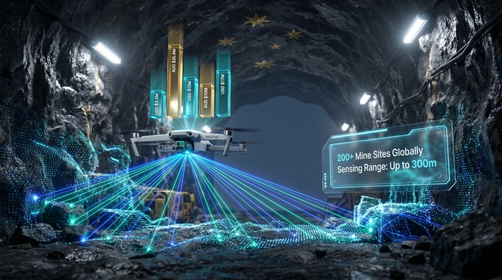
The sensing range of up to 300 metres in Emesent's systems is operationally significant. Many underground stopes and voids are large enough that a single deployment from a safe entry point can capture the full geometry without requiring the device to traverse hazardous interior spaces. This single-pass capture capability is what separates autonomous aerial mapping from ground-based robotic alternatives, which must physically navigate to each survey location. Furthermore, AI in mining environments continues to accelerate these technical capabilities in ways that would have seemed impractical only a few years ago.
Emesent's Capital Journey: Eight Years of Deliberate Platform Building
Understanding the current USD $17 million raise requires viewing it within the full funding architecture that precedes it. Emesent's capital progression has followed a pattern common to successful deep-tech hardware companies: prove the hardware, validate the market, build the software layer, then scale manufacturing.
| Round Year | Amount | Strategic Focus | Key Participants |
|---|---|---|---|
| 2018 | USD $3.5M | Hardware commercialisation for underground mining | Main Sequence Ventures, ACAC Innovation |
| 2021 | AUD $35.9M | Global geographic expansion; new product development | Perennial Partners |
| 2024 | USD $15M | Mine-mapping scale; early Cortex AI development | Undisclosed investors |
| 2024-2025 | AUD $10M (venture debt) | Batch manufacturing; Cortex customisation | National Reconstruction Fund Corporation |
| 2025-2026 | USD $17M | Cortex AI advancement; Aura cloud upgrades; Queensland production scaling | Main Sequence, QIC Ventures, Orion Resource Partners, Hostplus, NGS Super, NRFC |
Several structural observations emerge from this progression. The 2021 Series A at AUD $35.9M was the inflection point that signalled multi-market viability. The 2024 raise shifted the investment thesis from geography toward software intelligence. The most recent round formalises what the previous rounds were building toward: a vertically integrated autonomous mapping platform with scalable manufacturing behind it.
The NRFC's AUD $10M venture debt transaction, documented separately from the USD $17M equity raise, was notably the first venture debt transaction executed by the fund. This milestone matters because venture debt is typically extended to companies with proven revenue generation and a clear path to profitability. Its use by a government industrial fund signals that Emesent had, by that point, demonstrated commercial traction sufficient to underwrite debt-based capital rather than requiring pure equity risk.
Dissecting the USD $17 Million: Three Distinct Investment Targets
The most recent funding package is not a general working capital raise. It is explicitly allocated across three discrete technology and operational priorities, each representing a different layer of Emesent's platform architecture.
Cortex AI: Autonomy Without a Pilot
Cortex is the onboard intelligence system that enables Hovermap devices to navigate, avoid obstacles, and execute complete mapping missions without real-time human control. Current investment targets enhanced decision-making logic, specifically the ability to adapt autonomously to dynamic underground conditions.
This distinction matters more than it might initially appear. Earlier generations of autonomous mapping systems still required an operator to monitor the mission and intervene in unexpected situations. True operational autonomy requires the system to encounter an unplanned obstacle, a structural collapse, or an unexpected void geometry, and make an appropriate navigational decision without human input. Cortex AI investment is directed at closing that gap. Indeed, mining automation trends suggest this shift toward fully autonomous decision-making is now a sector-wide priority rather than a competitive differentiator held by a single vendor.
Aura Cloud: Converting Raw Data Into Mine Intelligence
The Aura platform sits between field data capture and mine planning systems. Raw point clouds captured underground contain enormous spatial detail but require processing, georeferencing, quality filtering, and visualisation before they become usable planning inputs. Aura handles this processing layer and delivers outputs as navigable 3D models accessible to engineering teams regardless of their physical location.
Planned upgrades focus on two operational priorities: faster processing throughput, so that data captured during a shift is available for planning decisions within the same operational day, and enhanced multi-user collaboration tools. These tools allow geotechnical engineers, mine planners, and survey teams to work simultaneously within the same 3D environment. In addition, 3D geological modelling capabilities are increasingly expected to integrate directly with these cloud platforms for seamless subsurface intelligence workflows.
Queensland Manufacturing: Removing the Supply Constraint
Production capacity expansion for both the Hovermap ST-X and GX1 scanner variants directly addresses a commercial bottleneck that has likely constrained adoption among mid-tier and junior mining operators. Extended equipment lead times create genuine operational barriers for mines with tight development schedules. Scaling the Queensland facility shortens the supply chain for Australian clients and establishes domestic manufacturing credibility relevant to export market positioning.
The NRFC Investment: Sovereign Capital in Advanced Manufacturing
The USD $7 million contribution from the National Reconstruction Fund Corporation within the latest raise represents a deliberate industrial policy investment rather than a financial return-driven decision in isolation. The NRFC's legislative mandate directs capital toward strengthening Australian advanced manufacturing across seven defined priority sectors, with robotics and autonomous systems explicitly named among them.
NRFC CEO David Gall has publicly described robotics and autonomous systems as emerging critical segments of the Australian economy, noting that investments of this type are intended to anchor these capabilities domestically. This framing is consistent with a broader sovereign manufacturing logic: advanced robotics developed and manufactured in Australia can serve global resource industries while retaining intellectual property, employment, and supply chain infrastructure within the country.
The strategic calculus behind this investment extends beyond Emesent specifically. Australia operates some of the world's most productive underground hard-rock mining operations, particularly in Western Australia and Queensland. Technologies that improve the safety, efficiency, and spatial intelligence of those operations carry direct economic value for the national resource sector, independent of any single company's commercial performance.
The next major ASX story will hit our subscribers first
Tier-One Validation and the Ecosystem Integration Advantage
Deployment across more than 200 mine sites globally, including operations run by Rio Tinto, BHP, and Glencore, provides Emesent with something that no amount of capital can purchase directly: reference site credibility at the highest level of the mining industry. For a closer look at how Hovermap operates in live underground environments, detailed technical coverage is available from specialist mining technology publications.
Tier-one miners operate with extensive internal technology evaluation processes. A vendor that has cleared those processes and achieved operational deployment at scale across multiple majors has cleared the highest commercial validation bar available in the mining technology market. For mid-tier operators evaluating autonomous mapping systems, this track record substantially reduces perceived adoption risk.
The hardware ecosystem integrations deepen this competitive position:
- Compatibility with Boston Dynamics Spot extends deployment capability into confined spaces where aerial flight is impractical, including low-clearance drives and pipe corridors
- Integration with Pointerra3D connects Hovermap data capture to enterprise digital twin workflows, allowing point cloud data to feed directly into asset management and mine planning software environments
- Long-range radio accessories enable real-time data preview transmission even in deep underground sections without communications infrastructure
Comparing Underground Mapping Approaches
| Capability | Manual Survey | Outdoor Drone LiDAR | Ground Robot LiDAR | Hovermap with SLAM |
|---|---|---|---|---|
| GPS Required | Yes | Yes | No | No |
| Human Entry Needed | Yes | Partial | No | No |
| Hazardous Environment Use | Low | Low | Moderate | High |
| Maximum Effective Range | Access-limited | Variable | Terrain-limited | Up to 300m |
| Real-Time Data Preview | No | Partial | Partial | Yes |
| AI-Driven Autonomy | None | Limited | Variable | Cortex AI |
| Cloud Analytics Integration | Manual | Variable | Variable | Native (Aura) |
Competitive Note: The differentiation argument for integrated autonomous aerial SLAM systems is most compelling precisely in the environments where all alternatives fail simultaneously: large underground voids with no GPS signal, active hazards preventing human entry, and complex three-dimensional geometry beyond ground robot range.
Three Structural Forces Driving Capital Into Underground Autonomy
The Emesent funding story does not exist in isolation. It reflects three converging pressures that are reshaping how the global mining industry invests in subsurface intelligence.
Regulatory Evolution Across Major Jurisdictions
Occupational health and safety frameworks in Australia, Canada, and the European Union are progressively tightening requirements for geotechnical assessment and hazard identification before human entry into unsupported underground workings. As these requirements strengthen, autonomous mapping systems transition from productivity tools into compliance infrastructure, creating non-discretionary demand rather than optional capital expenditure.
The Digital Twin Requirement in Modern Mine Planning
Mine planning methodologies built around continuous 3D subsurface model updates require data collection rates that periodic manual surveys cannot economically support. Autonomous systems capable of rapid redeployment after each blast cycle, capturing updated void geometry for immediate integration into planning software, are becoming foundational to precision mining approaches at the operational frontier. Consequently, data-driven mining operations are increasingly dependent on autonomous spatial capture as their primary input layer.
Structural Labour Constraints in Remote Operations
Qualified underground surveyors represent a constrained professional labour pool. In remote Australian, Canadian, and West African mining regions, recruiting and retaining specialist survey personnel adds operational cost and scheduling risk that autonomous systems directly address. This is a structural workforce challenge unlikely to resolve through training pipeline investment on any near-term timeline. Furthermore, AI-driven exploration programmes are beginning to demonstrate that the same autonomous logic underpinning underground mapping can be extended to surface and near-surface prospecting workflows.
What the Funding Trajectory Signals for Investors and Operators
Disclaimer: The following section contains forward-looking observations and scenario analysis. These represent analytical perspectives based on publicly available information and should not be construed as financial advice or investment recommendations.
The combination of private venture capital, superannuation fund participation through Hostplus and NGS Super, resources-focused capital from Orion Resource Partners, and sovereign government investment within a single funding round is structurally unusual. It suggests that Emesent's risk profile has evolved from early-stage technology speculation toward something closer to infrastructure asset investment.
When institutional superannuation funds allocate to a deep-tech hardware company, they are typically not expressing a view on near-term product innovation. They are expressing a view on durable, scalable cash flows from an established product with demonstrated enterprise adoption. The presence of Hostplus and NGS Super in this round indicates that at least some institutional capital has reached that assessment about Emesent's current commercial position.
For mining operators still evaluating autonomous mapping technology, the manufacturing scale-up funded by this raise has a practical implication: equipment availability constraints that may have previously extended deployment timelines are likely to ease as Queensland production capacity increases. The operational case for Emesent funding for autonomous mining mapping systems, already validated by tier-one operators across 200-plus sites, is now being reinforced by the supply-side infrastructure needed to support broader market penetration.
For further context on mining technology investment trends and autonomous systems deployment in global mining operations, the Canadian Mining Journal provides ongoing coverage of equipment and technology developments across the sector.
Want To Identify the Next Major ASX Mining Discovery Before the Market Does?
Discovery Alert's proprietary Discovery IQ model scans ASX announcements in real time, instantly identifying significant mineral discoveries across more than 30 commodities — the same kind of transformative opportunities seen in companies like De Grey Mining and WA1 Resources — so begin your 14-day free trial at Discovery Alert today, or explore the historic returns major discoveries have generated to understand what's at stake.