June 17, 2026
Mining operations require precise coordination between subsurface exploration and practical extraction methods. The intersection of geological science and mining engineering represents one of industry's most critical technical partnerships, where theoretical earth science knowledge transforms into operational mining strategies. This collaboration determines whether mineral deposits become profitable ventures or costly failures, influencing everything from initial resource assessment through final site rehabilitation.
Modern mineral extraction demands sophisticated understanding of both geological formations and engineering principles. Each discipline contributes essential expertise that, when properly integrated, enables safe and economically viable mining operations across diverse geological environments.
Understanding the Fundamental Partnership Between Earth Sciences and Mining Engineering
The relationship between engineering and geology in mining extends far beyond simple collaboration. These disciplines form an integrated technical framework where geological data directly informs engineering decisions, while engineering constraints shape geological investigation priorities. This partnership has evolved significantly since early mining operations relied primarily on surface observations and basic mechanical extraction methods.
Contemporary mining operations depend on geological models that predict subsurface conditions with increasing accuracy. Engineering teams utilise this geological intelligence to design extraction systems, optimise equipment selection, and establish safety protocols tailored to specific site conditions. The economic success of mining ventures often correlates directly with the quality of this geology-engineering integration.
Resource characterisation represents the foundation of this partnership. Geological teams conduct comprehensive subsurface investigations using advanced techniques including three-dimensional seismic surveys, magnetic and gravitational measurements, and systematic drilling programmes. These investigations generate detailed maps of ore body geometry, structural features, and hydrogeological conditions that engineering teams require for operational planning.
The financial implications of effective geology-engineering collaboration are substantial. Industry analysis indicates that mining projects with well-integrated geological and engineering assessment typically achieve 15-25% higher operational efficiency compared to projects where these disciplines operate independently. This efficiency gain translates directly into improved project economics and reduced operational risks.
Professional mining organisations increasingly emphasise interdisciplinary training programmes that develop expertise spanning both geological and engineering domains. The Society for Mining, Metallurgy & Exploration reports growing demand for professionals who understand both earth science principles and engineering applications, reflecting industry recognition of this integration's strategic importance.
When big ASX news breaks, our subscribers know first
What Role Does Geological Assessment Play in Mine Development?
Geological assessment provides the scientific foundation upon which all mining engineering decisions rest. This process involves systematic investigation of subsurface conditions, mineral distribution patterns, and geological hazards that could affect extraction operations. Comprehensive geological assessment typically requires 18-36 months for major projects, depending on deposit complexity and accessibility.
Resource Characterisation and Deposit Evaluation
Subsurface mapping techniques employ sophisticated geophysical methods to characterise ore bodies before extensive drilling programmes commence. Furthermore, 3D geological modelling enables detailed visualisation of complex geological structures. Modern geological surveys utilise:
• High-resolution aeromagnetic surveys that identify magnetic anomalies indicating potential mineral concentrations
• Induced polarisation measurements detecting subsurface electrical properties associated with specific ore types
• Ground-penetrating radar systems mapping shallow geological features and structural discontinuities
• Seismic reflection surveys providing detailed images of geological structures at various depths
Ore grade distribution analysis through systematic sampling programmes establishes the economic viability of potential mining operations. Industry standards typically require sample spacing between 25-50 metres for preliminary resource estimation, with closer spacing needed for detailed reserve calculations. These programmes generate thousands of individual assay results that geostatistical analysis transforms into three-dimensional grade models.
Structural geology interpretation for understanding fault systems and rock stability represents a critical safety consideration. Geological mapping identifies major structural features including fault zones, shear systems, and rock mass discontinuities that directly influence:
- Pit wall stability in open-pit operations
- Underground excavation design requirements
- Groundwater flow patterns and dewatering needs
- Potential geotechnical hazards during extraction
Hydrogeological assessments predict groundwater behaviour during extraction, enabling engineering teams to design appropriate dewatering systems and water management infrastructure. These studies typically involve 12-24 months of groundwater monitoring to establish baseline conditions and seasonal variation patterns.
Geochemical Analysis and Mineral Processing Implications
Laboratory testing protocols for ore composition extend beyond simple grade determination to include detailed mineralogical analysis, metallurgical testing, and environmental characterisation. Standard geochemical analysis packages examine 30-50 elements, providing comprehensive understanding of ore composition and potential processing challenges.
Metallurgical characteristics that influence processing methods require specialised testing programmes. These investigations determine:
• Liberation characteristics indicating required crushing and grinding specifications
• Recovery potential through flotation, leaching, or other separation processes
• Concentrate quality specifications meeting downstream customer requirements
• Processing cost estimates based on ore hardness, mineral associations, and recovery rates
Environmental geochemistry considerations for waste management have become increasingly important as regulatory requirements evolve. Acid base accounting studies assess potential for acid mine drainage generation, while trace element analysis identifies environmental monitoring requirements and potential treatment needs.
Quality control parameters for consistent product output require ongoing geological oversight throughout mining operations. Statistical analysis of production data enables geological teams to predict grade variation patterns and optimise mine planning to maintain consistent feed quality to processing facilities.
How Do Mining Engineers Transform Geological Data into Operational Plans?
Mining engineers serve as the critical interface between geological understanding and practical extraction operations. This transformation process requires sophisticated technical analysis combining geological data with engineering principles to create viable mining plans that balance economic objectives with operational constraints and safety requirements.
Mine Design Integration Process
Engineering teams utilise geological data through systematic analysis frameworks that translate earth science information into operational parameters. Computer-aided mine design software integrates geological block models with engineering constraints to optimise extraction sequences, equipment selection, and infrastructure requirements.
| Geological Factor | Engineering Application | Operational Impact |
|---|---|---|
| Rock strength properties | Slope angle calculations | Safety margins and pit design |
| Groundwater flow patterns | Dewatering system design | Operational costs and timeline |
| Ore body geometry | Extraction sequence planning | Equipment selection and productivity |
| Structural discontinuities | Ground support requirements | Worker safety and infrastructure |
The integration process begins with geological block models that discretise ore bodies into manageable computational units. Individual blocks typically measure 5-25 metres on each side, with smaller blocks used in areas requiring greater precision. Each block contains geological attributes including grade, rock type, geotechnical properties, and environmental characteristics that engineering analysis utilises.
Pit optimisation algorithms process geological block models to determine optimal extraction boundaries. These calculations consider commodity prices, operating costs, geotechnical constraints, and processing capacities to maximise project net present value. Modern optimisation software can evaluate millions of potential pit configurations to identify optimal solutions.
Extraction Method Selection Criteria
Open-pit feasibility analysis based on overburden ratios and deposit geometry represents the primary decision criterion for surface mining operations. Industry standards indicate that overburden ratios exceeding 3:1 typically favour underground methods for most commodity types, though specific economic conditions and geological characteristics can modify this threshold.
Surface mining advantages include:
- Lower unit operating costs for shallow deposits
- Higher production rates and equipment productivity
- Simplified logistics and material handling
- Enhanced safety through improved access and visibility
Underground mining considerations for deep or complex ore bodies involve comprehensive analysis of geological conditions, extraction costs, and safety requirements. Underground methods become economically attractive when:
• Deposit depth exceeds 300-500 metres depending on commodity value and geological conditions
• Ore body geometry features high grade zones with well-defined boundaries
• Rock mass stability permits safe excavation of underground openings
• Environmental constraints limit surface disturbance or noise generation
Hybrid extraction approaches combining surface and subsurface methods offer operational flexibility for complex deposits. These strategies might involve initial open-pit development followed by underground extraction of deeper zones, or simultaneous surface and underground operations targeting different ore zones within the same deposit.
Equipment specifications matching geological conditions and production targets require detailed analysis of material handling requirements, geological conditions, and operational constraints. Geological characteristics directly influence equipment selection through factors including:
- Rock hardness affecting drill and blast requirements
- Ore body geometry determining loading equipment specifications
- Ground conditions influencing haul road design and truck selection
- Environmental factors affecting dust control and noise management systems
What Advanced Technologies Bridge Geology and Engineering in Mining?
Digital transformation has revolutionised the integration of geological knowledge and engineering practice in mining operations. Advanced technologies now enable real-time data sharing, sophisticated modelling capabilities, and predictive analytics that enhance decision-making throughout the mining lifecycle.
Digital Integration and Data Management Systems
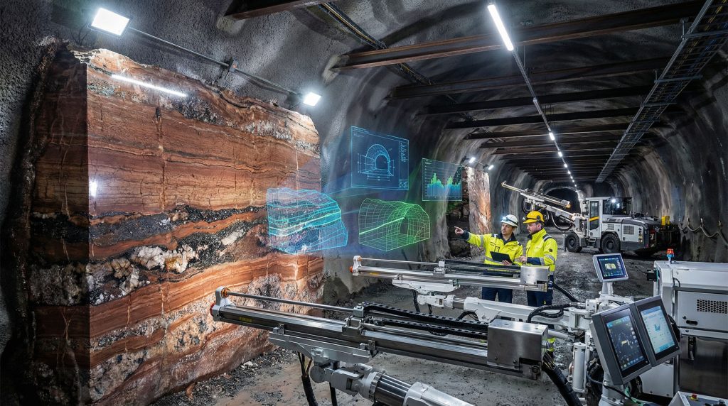
Three-dimensional geological modelling software creates detailed subsurface visualisations that engineering teams utilise for mine planning and operational optimisation. Modern geological modelling platforms integrate multiple data types including drill hole information, geophysical surveys, geological mapping, and geotechnical testing results into coherent three-dimensional representations.
Leading geological modelling software platforms process datasets containing millions of individual data points to generate accurate subsurface models. These systems employ advanced interpolation algorithms including ordinary kriging, indicator kriging, and sequential Gaussian simulation to predict geological conditions between data collection points.
Real-time monitoring systems track ground movement and stability using networks of sensors that provide continuous data streams to both geological and engineering teams. These monitoring programmes typically include:
• Global positioning system (GPS) networks measuring surface displacement with millimetre precision
• Inclinometer installations detecting subsurface ground movement in potentially unstable areas
• Piezometer systems monitoring groundwater pressure changes that could affect slope stability
• Seismic monitoring arrays detecting micro-seismic activity indicating ground stress changes
Predictive analytics platforms forecast geological hazards and equipment performance using machine learning algorithms trained on historical operational data. These systems can predict equipment maintenance requirements, identify potential geological hazards, and optimise production schedules based on geological conditions and operational constraints.
Integrated database systems combine geological, engineering, and operational data in unified platforms that enable comprehensive analysis and reporting. Industry-standard database systems typically manage terabytes of information including drill hole logs, assay results, geotechnical data, production records, and environmental monitoring data.
Remote Sensing and Automation Applications
Drone-based geological surveys provide rapid terrain assessment capabilities that complement traditional ground-based investigation methods. Unmanned aerial vehicle (UAV) systems equipped with high-resolution cameras and multispectral sensors can survey large areas quickly while generating detailed geological maps and identifying potential hazard areas.
Modern UAV geological surveys achieve ground sampling distances of 2-5 centimetres, enabling detailed structural mapping and hazard identification that would require weeks of ground-based work. These systems particularly benefit operations in remote or hazardous areas where traditional mapping methods pose safety or logistical challenges.
Automated drilling systems guided by geological models improve drilling accuracy and efficiency while reducing safety risks. Computer-controlled drilling systems can maintain precise hole orientation and depth control based on pre-programmed geological targets, achieving drilling accuracies within 1-2 degrees of planned trajectories.
Machine learning algorithms for ore grade prediction utilise pattern recognition techniques to identify geological trends and predict unmeasured locations. These systems analyse complex relationships between geological variables including structure, alteration patterns, and geochemical signatures to improve resource estimation accuracy.
Sensor networks monitor geotechnical conditions continuously throughout mining operations, providing early warning of potential stability problems. Distributed sensor systems can monitor hundreds of individual measurement points simultaneously, transmitting data via wireless networks to central monitoring stations where automated alert systems notify personnel of developing hazards.
How Do Safety Protocols Integrate Geological and Engineering Expertise?
Safety management in mining operations requires seamless integration of geological hazard assessment and engineering risk mitigation strategies. This collaborative approach combines earth science understanding of natural hazards with engineering solutions designed to protect personnel and equipment throughout mining operations.
Geotechnical Risk Assessment Framework
Slope stability monitoring using geological structure analysis and engineering calculations represents a fundamental safety requirement for surface mining operations. Comprehensive slope stability programmes integrate multiple assessment techniques:
Geological analysis identifies structural features including joint sets, fault systems, and bedding planes that could influence slope behaviour. Structural mapping typically documents thousands of individual measurements to establish statistical representations of rock mass discontinuity patterns that engineering analysis utilises for stability calculations.
Engineering calculations employ limit equilibrium analysis, continuum mechanics modelling, and probabilistic approaches to quantify slope stability under various loading conditions. Factor of safety calculations typically target minimum values of 1.3-1.5 for operational slopes, with higher factors required for critical infrastructure areas.
Real-time monitoring systems provide continuous assessment of slope performance using networks of precision instruments. Modern monitoring programmes can detect slope movements at sub-millimetre precision, enabling early warning systems that trigger operational responses before significant failures occur.
Ground control systems designed from rock mechanics principles ensure underground excavation stability through systematic support installation programmes. These systems consider:
• Rock mass quality indices (RMR, Q-system, GSI) quantifying geological conditions
• In-situ stress measurements determining natural stress states affecting excavation stability
• Support system design specifying rockbolt patterns, mesh installation, and concrete application requirements
• Performance monitoring tracking support system effectiveness and identifying areas requiring additional reinforcement
Hazard identification protocols combine geological mapping with engineering risk assessment to systematically identify and evaluate potential safety threats. These protocols typically involve:
- Daily geological inspections documenting changing ground conditions
- Weekly engineering assessments evaluating cumulative risk factors
- Monthly comprehensive reviews integrating operational data with geological observations
- Annual programme reviews updating risk assessment methodologies and safety procedures
Emergency response planning based on geological hazard scenarios ensures appropriate response capabilities for various potential incidents. Emergency plans typically address scenarios including slope failures, ground collapse, water inflows, and seismic events, with response procedures tailored to specific geological conditions and operational configurations.
Environmental Compliance and Monitoring
Geological baseline studies for environmental impact assessment establish pre-mining environmental conditions that regulatory compliance monitoring programmes utilise throughout operations. Comprehensive baseline studies typically require 24-36 months of data collection to establish natural variation patterns in groundwater quality, surface water flows, and ecological conditions.
Engineering controls for acid mine drainage prevention integrate geological understanding of sulfide mineral distribution with engineered systems designed to minimise oxidation and neutralise acidic drainage. Prevention strategies include:
• Waste rock segregation separating potentially acid-generating materials from non-acid-generating waste
• Encapsulation systems covering acid-generating materials with alkaline materials or impermeable barriers
• Water management infrastructure minimising water contact with sulfide-bearing materials
• Treatment systems neutralising acidic drainage through limestone addition or constructed wetland systems
Groundwater protection systems based on hydrogeological modelling utilise geological understanding of aquifer systems to design monitoring networks and containment systems. Typical groundwater monitoring programmes include 20-50 monitoring wells positioned to detect potential contamination before it reaches sensitive environmental receptors.
Rehabilitation planning incorporates geological restoration principles with engineering design to create stable, environmentally acceptable post-mining landscapes. Successful mine reclamation innovation requires:
- Geological assessment of rehabilitation material sources and placement requirements
- Engineering design of final landforms ensuring long-term stability
- Environmental planning establishing vegetation and wildlife habitat objectives
- Monitoring programmes tracking rehabilitation performance against established criteria
What Career Pathways Exist at the Intersection of Geology and Mining Engineering?
Professional opportunities spanning geology and engineering and geology in mining have expanded significantly as industry recognises the value of interdisciplinary expertise. These career pathways combine earth science knowledge with engineering applications, creating specialised roles that command premium compensation and offer diverse professional development opportunities.
Specialized Professional Roles
Engineering geologists focus on applied geological solutions for mining challenges, combining geological training with practical problem-solving skills. These professionals typically hold geological degrees supplemented by engineering coursework or professional experience. Entry-level engineering geologist positions typically offer salaries 15-25% above standard geological roles, reflecting the specialised skill requirements.
Key responsibilities include:
• Site characterisation for mining infrastructure including processing facilities, tailings storage, and waste rock disposal areas
• Geotechnical investigation supporting pit slope design, underground excavation planning, and foundation engineering
• Hazard assessment identifying geological risks and recommending mitigation strategies
• Construction support providing geological oversight during infrastructure development
Geotechnical engineers specialising in rock and soil mechanics for mining applications apply engineering principles to geological materials and conditions. These positions require engineering degrees with specialised training in rock mechanics, soil mechanics, and geological engineering principles.
Professional responsibilities encompass:
- Rock mass characterisation and strength testing programmes
- Slope stability analysis and monitoring system design
- Underground support system design and performance evaluation
- Foundation engineering for mining infrastructure and equipment
Resource evaluation specialists combine geological knowledge with economic analysis to assess mineral deposit viability and optimise extraction strategies. These roles typically require geological training supplemented by business, economics, or financial analysis education.
Mine planning engineers integrate geological constraints with operational optimisation to develop comprehensive extraction strategies. These positions represent senior-level opportunities typically requiring 5-10 years of combined geological and engineering experience. Senior mine planning engineers often earn salaries exceeding $150,000 annually, reflecting their strategic importance to mining operations.
Professional Development and Certification Requirements
University degree combinations in geology and mining engineering provide the academic foundation for interdisciplinary careers. Several universities now offer specialised programmes including:
• Geological engineering degree programmes combining geological science with engineering mathematics and design principles
• Mining engineering programmes with geological specialisation tracks
• Dual degree programmes enabling students to complete both geological and engineering qualifications
• Graduate certificate programmes allowing working professionals to add complementary expertise
Professional registration requirements vary by jurisdiction but typically require demonstrated competency in both geological and engineering principles. Professional Engineer (P.E.) or Professional Geoscientist (P.Geo.) registration often requires additional examination and experience requirements for interdisciplinary practitioners.
Continuing education in emerging technologies and regulatory changes represents an ongoing professional requirement. Industry organisations provide specialised training programmes addressing:
- Advanced geological modelling and geostatistical analysis techniques
- Mine safety regulations and compliance requirements
- Environmental assessment and monitoring methodologies
- Project management and business skills for technical professionals
Furthermore, professionals can explore careers in mining engineering at leading universities. Additionally, careers in geoscience engineering geology offer diverse specialisation opportunities.
Industry-specific certifications for specialised equipment and methodologies enhance career advancement opportunities. Certified Mine Safety Professional (CMSP) and Certified Professional in Erosion and Sediment Control (CPESC) represent examples of specialised certifications valued by mining employers.
The next major ASX story will hit our subscribers first
How Do Economic Factors Influence the Geology-Engineering Interface?
Economic considerations fundamentally shape the integration of geological knowledge and engineering practice throughout mining project lifecycles. Commodity price volatility, capital cost constraints, and operational efficiency requirements create dynamic pressures that influence how geological and engineering teams collaborate and make technical decisions.
Financial Optimisation Through Technical Integration
Resource estimation accuracy directly impacts investment decisions and project financing, with estimation errors potentially affecting project valuations by millions of dollars. Industry analysis indicates that geological resource estimates with confidence intervals exceeding ±20% often struggle to secure development financing, emphasising the importance of high-quality geological data collection and analysis.
Modern resource estimation programmes typically invest $2-5 million in geological investigation for major mining projects, with this investment potentially influencing project valuations by $50-200 million depending on deposit size and commodity value. The economic return on geological investigation investment frequently exceeds 10:1 for well-executed programmes.
Operational efficiency improvements through geological understanding and engineering optimisation can significantly impact mining economics. Operations that effectively integrate geological grade control with engineering extraction planning typically achieve:
• 5-15% improvement in mill feed grade through selective mining practices guided by geological models
• 10-20% reduction in waste mining costs through optimised pit design based on accurate geological boundaries
• 15-25% improvement in equipment productivity through geological hazard prediction and engineering mitigation
Risk mitigation strategies reduce financial exposure through technical expertise, with comprehensive geological and engineering risk assessment programmes often reducing insurance costs and improving project financing terms. Projects with integrated risk management programmes typically secure financing at 0.5-1.5% lower interest rates, reflecting reduced perceived risk.
Technology investment decisions balance geological complexity with engineering solutions, requiring careful analysis of costs and benefits. Advanced geological modelling systems and engineering optimisation software typically require initial investments of $500,000-2 million but can generate operational savings exceeding $5-10 million annually for large mining operations.
Market Responsiveness and Production Planning
Geological flexibility enables rapid response to commodity price changes through selective mining strategies that adjust production to market conditions. Mining operations with detailed geological models can modify production plans within weeks rather than months required for operations lacking sophisticated geological control.
Engineering adaptability for varying production requirements depends on geological understanding of deposit characteristics and operational constraints. Operations can typically increase production rates by 20-30% above baseline levels when geological conditions permit and engineering systems can accommodate higher throughput rates.
Long-term planning incorporates geological reserves and engineering capabilities to optimise project value across commodity price cycles. Strategic mine plans typically evaluate scenarios across 20-30 year time horizons, considering geological depletion patterns, engineering infrastructure requirements, and anticipated market conditions.
Supply chain optimisation based on geological quality predictions enables mining operations to negotiate favourable contracts with customers and suppliers. Geological grade control programmes that maintain product quality within ±3% specifications often command premium pricing and long-term contract opportunities.
What Future Trends Are Shaping Geology and Engineering Integration in Mining?
Technological advancement and evolving industry requirements are transforming how geological expertise and engineering practice integrate in mining operations. These trends reflect broader changes in technology adoption, environmental expectations, and workforce development that will define the mining industry evolution over the next decade.
Emerging Technologies and Methodologies
Artificial intelligence applications in geological pattern recognition and engineering optimisation represent perhaps the most significant technological development affecting geology-engineering integration. Machine learning systems can now analyse complex geological datasets containing millions of data points to identify subtle patterns that human analysis might miss.
In addition, AI in mining operations demonstrates particular effectiveness in:
• Ore grade prediction with accuracy improvements of 15-25% compared to conventional geostatistical methods
• Geotechnical hazard detection providing early warning of slope stability problems or ground control issues
• Equipment optimisation matching geological conditions with optimal operational parameters
• Exploration targeting identifying prospective areas based on complex geological and geochemical relationships
Sustainable mining practices require enhanced geological understanding and engineering innovation to minimise environmental impacts while maintaining operational efficiency. Carbon emission reduction targets of 30-50% by 2030 adopted by major mining companies necessitate fundamental changes in mining practices including:
- Selective mining strategies minimising waste generation and processing requirements
- Energy-efficient extraction methods reducing fuel consumption and emissions
- Renewable energy integration requiring geological assessment of site suitability
- Water conservation systems based on detailed hydrogeological understanding
Precision mining techniques demand tighter integration between geological models and engineering systems to optimise resource recovery while minimising waste generation. These approaches can improve resource recovery rates by 10-20% while reducing environmental footprint through selective extraction methods.
Climate change adaptation necessitates new approaches to geological hazard assessment as changing precipitation patterns, temperature regimes, and extreme weather events affect mining operations. Geological hazard assessment now incorporates climate projection models to predict how changing conditions might affect slope stability, groundwater behaviour, and environmental performance.
Industry Evolution and Workforce Development
Increasing demand for professionals with cross-disciplinary expertise reflects industry recognition that traditional disciplinary boundaries limit operational effectiveness. Job postings for mining positions increasingly specify requirements for both geological and engineering knowledge, with compensation premiums of 20-40% for professionals demonstrating integrated expertise.
University programmes adapt curricula to emphasise integrated approaches, with new degree programmes specifically designed to develop professionals capable of working across traditional disciplinary boundaries. Enrollment in geological engineering programmes has increased 35% over the past five years, indicating growing recognition of career opportunities in interdisciplinary fields.
Professional societies develop new standards for collaborative practice, establishing competency frameworks and certification programmes for integrated geology-engineering practice. The Society for Mining, Metallurgy & Exploration recently launched specialised certification programmes for integrated geological-engineering practice to meet industry demand for qualified professionals.
Technology companies create specialised software for geology-engineering integration, with software development investments exceeding $100 million annually in mining-specific applications. These investments focus on platforms that enable seamless data sharing, integrated analysis capabilities, and collaborative decision-making workflows.
Furthermore, data-driven mining operations increasingly rely on integrated geological and engineering datasets to optimise performance and reduce operational risks.
Key Takeaways for Mining Industry Professionals
The integration of geological expertise and mining engineering excellence represents a fundamental competitive advantage that distinguishes successful mining operations from marginal performers. This collaboration extends beyond simple coordination between disciplines to create synergistic relationships where combined expertise exceeds the sum of individual contributions.
Professional development opportunities in integrated geology-engineering practice offer attractive career pathways with compensation premiums and diverse advancement possibilities. The mining industry increasingly values professionals who can bridge traditional disciplinary boundaries and contribute to integrated decision-making processes.
Technological advancement continues expanding the possibilities for geology-engineering integration, with artificial intelligence, advanced modelling capabilities, and real-time monitoring systems creating new opportunities for operational optimisation and risk management. Early adopters of integrated technologies report operational efficiency improvements of 15-30%, establishing competitive advantages in increasingly challenging market conditions.
Regulatory and environmental requirements increasingly demand integrated approaches that consider geological characteristics, engineering solutions, and environmental protection simultaneously. Projects that integrate these considerations from initial planning stages typically achieve regulatory approval 6-12 months faster than projects addressing these requirements separately.
The future of mining success depends increasingly on organisations that can effectively integrate geological knowledge with engineering innovation to create sustainable, profitable, and socially responsible operations. Investment in integrated geology-engineering capabilities represents strategic positioning for mining companies seeking long-term competitive advantage in evolving market conditions.
Understanding both geological principles and engineering applications enables mining professionals to make informed decisions that balance technical feasibility with economic objectives and environmental responsibilities. This integrated perspective contributes to mining operations that can adapt to changing conditions, optimise resource recovery, and maintain operational excellence throughout project lifecycles.
Want to Stay Ahead of ASX Mineral Discovery Announcements?
Discovery Alert's proprietary Discovery IQ model delivers instant notifications on significant ASX mineral discoveries, transforming complex geological data into actionable investment insights for both short-term traders and long-term investors. Start your 14-day free trial with Discovery Alert today to gain immediate market advantages when major discoveries are announced.