June 16, 2026
The Science of Accumulated Evidence: Why Geological Memory in Mineral Exploration Defines Discovery Probability
Across the long arc of mineral exploration history, the projects that have generated the most capital-efficient discoveries share a common trait that rarely appears in a company's headline metrics. It is not acreage size, management pedigree, or even commodity price timing. It is the depth and coherence of accumulated geological evidence that underpins every targeting decision before a single drill rod enters the ground. Understanding how this evidence compounds over time, and why its absence forces explorers to rebuild interpretive frameworks from scratch at enormous cost, is fundamental to evaluating the real risk profile of any exploration-stage investment.
This concept, increasingly referred to within technical exploration circles as geological memory in mineral exploration, describes the body of physical, chemical, and structural information that past ore-forming processes leave behind in rocks, soils, alteration patterns, and survey records. When these historical signals are not just archived but actively integrated into a coherent geological model, they function as a precision targeting system, narrowing the universe of possible drill locations and compressing the timeline from licence acquisition to maiden resource.
When big ASX news breaks, our subscribers know first
Why Isolated Datasets Fail and Convergence Succeeds
The fragmented nature of historical exploration is one of the least-discussed sources of capital destruction in the junior mining sector. Airborne radiometric surveys flown during periods of elevated commodity interest, soil geochemistry programmes conducted under different ownership structures, radon traverses completed years apart, and reconnaissance drilling campaigns that changed hands mid-programme have all generated vast quantities of data across Africa, Canada, and Australia. The challenge is not data scarcity. It is data integration.
In isolation, each dataset layer carries significant interpretive ambiguity. Airborne radiometric readings in counts per second (CPS) reflect a composite signal from uranium, thorium, and potassium simultaneously. Handheld scintillometers cannot distinguish between these sources. Radon-in-soil surveys are structurally informative but require calibration against known mineralised zones to establish meaningful anomaly thresholds. Furthermore, soil sampling programmes confirm or challenge anomaly locations but cannot resolve grade or continuity without drilling.
The mechanism that transforms inconclusive individual signals into high-confidence drill targets is spatial convergence within a coherent geological model. When an airborne radiometric anomaly, a radon soil response, and a soil geochemistry result align within the boundaries of a mapped favourable stratigraphic horizon, the probability of encountering mineralisation at depth rises materially. Each independent dataset that points toward the same location reduces the range of possible geological outcomes for the next phase of work.
In sedimentary uranium systems, a historical airborne anomaly acquires an entirely different level of significance when it spatially coincides with a radon soil response within a mapped favourable stratigraphic horizon. The convergence is the mechanism. Without it, anomalies remain speculative.
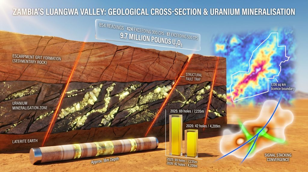
This principle is particularly well-demonstrated in the Karoo sedimentary basins of central and southern Africa, where uranium mineralisation is hosted within the Escarpment Grit Formation of the Upper Karoo Basin. Mineralisation concentrates at structural trap sites where cross-cutting faults intersect the favourable stratigraphic horizon, a geological architecture that has been understood for decades but requires multi-dataset confirmation to target efficiently at the drill-pad scale.
The Hidden Cost of Starting From Scratch
Exploration programmes that bypass historical data integration face a structural cost disadvantage that compounds over multiple drill campaigns. The limiting resource in cost-efficient mineral exploration is not drilling capacity. In Zambia, for example, cost-effective reverse circulation percussion drilling can be mobilised across vast licence packages at relatively low cost per metre. The true constraint is the quality of targeting intelligence before those rigs are deployed.
A greenfield position of equivalent size to a historically worked licence area carries a fundamentally different risk profile. Without a pre-existing targeting framework, every exploration phase must be conducted sequentially from scratch, starting with regional geophysics, progressing to ground confirmation, then geochemistry, then structural mapping, and finally drilling. Each phase carries the possibility of returning null results that consume capital without narrowing the geological model.
| Exploration Approach | Targeting Framework | Capital Efficiency | Risk Profile |
|---|---|---|---|
| Multi-decade layered datasets | Pre-built; requires refinement only | High, fewer wasted drill holes | Lower, multiple independent data confirmations |
| Single-season greenfield | Must be constructed from zero | Low, high discovery cost per pound | Higher, no prior signal calibration |
| Partial historical integration | Incomplete, gaps remain | Moderate | Moderate, dependent on data quality |
The compounding cost of the greenfield approach is rarely captured in project comparisons because the time value of the interpretive framework is not reported as a line item. However, an explorer who inherits 15 years of radiometric surveys, soil geochemistry results, radon traverses, and reconnaissance drilling effectively receives the equivalent of multiple exploration seasons of pre-work without the associated capital expenditure.
How Geological Memory Is Built: The Five-Layer Model
Geological memory in mineral exploration is not constructed in a single campaign. It accumulates through successive, calibrated phases of work, each of which simultaneously generates new information and recalibrates the interpretation of all prior data.
Layer One: Airborne Radiometrics and the Baseline Signal Problem
Regional airborne radiometric surveys provide broad-area anomaly identification across scales that ground programmes cannot efficiently replicate. However, the spatial resolution of airborne surveys, typically flown at line spacings of 200 to 400 metres or more, is insufficient to distinguish mineralisation-proximal signals from geologically related but non-economic radioactivity sources. Thorium-rich granites and potassium-bearing sediments can produce radiometric responses that superficially resemble uranium anomalies at regional scale.
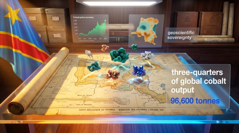
The 2006 airborne geophysical programme across the Muntanga Uranium Project in Zambia, held by Atomic Eagle Limited (ASX: AEU | OTCQX: AEUXF) across a 1,136-square-kilometre licence area, illustrates this limitation precisely. Anomalies were identified across multiple target areas, but broad spatial coverage without closely spaced ground confirmation left each anomaly inconclusive in isolation.
Layer Two: Ground Radiometrics and Anomaly Refinement
Ground radiometric surveys conducted at 100-metre line spacing and 50-metre station intervals provide the resolution needed to distinguish genuine mineralisation signals from background noise. At Muntanga North, a 53-kilometre ground radiometric programme completed in mid-2026 was designed specifically to refine anomalies first identified two decades earlier.
The results were statistically meaningful. Of 854 total readings recorded across 5 completed target areas:
- 424 readings exceeded the background threshold of 300 CPS, representing approximately 50% of all readings
- 87 readings exceeded 500 CPS, indicating elevated anomaly intensity
- Strike lengths of up to approximately 4 kilometres were identified
- Anomalies are located 15 to 25 kilometres from the established Muntanga and Dibbwi East deposits
As of mid-June 2026, surveys had been completed across 6 of 8 target areas, with two drill rigs deployed for the maiden Muntanga North drill programme.
Layer Three: Soil Geochemistry and Radon Surveys
Independent geochemical confirmation from soil sampling and radon-in-soil traverses provides the second cross-referencing layer. Radon surveys function as structural indicators, identifying zones where cross-cutting faults bring radon gas to surface, highlighting potential uranium trap sites. Soil and radon surveys conducted between 2013 and 2015 across the Muntanga licence provided this confirmatory layer for the anomalies later refined by the 2026 ground radiometric programme.
Layer Four: Structural and Stratigraphic Mapping
Assigning each refined anomaly to a specific host rock unit and structural setting is the interpretive step that separates high-probability targets from background noise. According to the USGS Mineral Resources Program, systematic structural characterisation is critical to understanding how mineralising fluids migrate and accumulate within prospective geological settings. In the Karoo sandstone uranium systems of Zambia, structural mapping identifies the cross-cutting fault orientations most frequently associated with mineralised trap sites, allowing the ground radiometric and geochemical anomalies to be ranked by geological plausibility before drilling commences.
Layer Five: Drilling as Definitive Verification
Reverse circulation (RC) drilling is the first method capable of definitively confirming elemental uranium concentration rather than composite radioactivity. In addition, downhole geophysics provides structural logging data that refines the geological model between drilling phases. Diamond drilling delivers the confirmatory follow-on, with representative core samples suitable for metallurgical testwork. Every drill campaign recalibrates the entire geological model for subsequent phases, and geological logging codes play an important role in ensuring that this data is captured consistently across programmes.
Chisebuka: Where Geological Memory Becomes Resource Growth
The Chisebuka target within the Muntanga project provides the most direct empirical evidence for how accumulated geological evidence translates into resource outcomes.
A 69-hole, 7,235-metre programme in 2025 converted the north-eastern zone of Chisebuka into a maiden inferred mineral resource estimate (MRE) of 19.9 million tonnes at 220 parts per million uranium oxide for 9.7 million pounds of U3O8, defined within an 800-metre by 600-metre footprint. This result was itself a product of geological memory, as the drilling programme was designed around the convergent geophysical and geochemical evidence accumulated across prior exploration cycles.
The 2026 expansion programme then targeted portions of the Chisebuka anomaly that historical survey work had flagged but the 2025 programme had not yet drill-tested. The results as of mid-2026 are instructive:
| Programme Phase | Holes Drilled | Metres Drilled | Zone Outcome |
|---|---|---|---|
| 2025 maiden programme | 69 | 7,235 m | 9.7 Mlb U3O8 inferred MRE at 220 ppm |
| 2026 expansion (to date) | 42 | 4,209 m | Northern zone: 900m x 600m; SW zone: 830m x 400m |
| 2026 RC programme (planned) | 12 | ~900 m | Grade confirmation and zone linkage |
| Q4 2026 diamond drilling | TBD | TBD | Grade confirmation and metallurgical testwork |
Of the first 15 holes in the 2026 programme, 13 intersected uranium mineralisation outside the previously defined resource boundary. Selected intercepts included 12.7 metres at 673 parts per million equivalent uranium oxide from 18.0 metres depth and 24.0 metres at 448 parts per million equivalent uranium oxide from 32.2 metres depth. By mid-2026, with 42 holes completed for 4,209 metres, both the northern higher-grade zone and the south-west zone had expanded substantially, with drilling confirming structural continuity between them.
The economic logic behind continued resource expansion at Chisebuka is tied directly to mine life and production scale. A satellite deposit growing toward the 15-million-pound range, spread across a 15-year mine life, contributes approximately one million pounds per year of incremental feed to a central processing facility, a meaningful production increment at prevailing uranium prices that could materially influence project economics.
The Sitwe Option: Applying the Same Framework to a Second Basin
The May 2026 binding option agreement to acquire 100% of the Sitwe Uranium Project in the Luangwa Valley of north-eastern Zambia demonstrates how the geological memory framework is applied to licence acquisition strategy, not just exploration execution.
Sitwe covers 429 square kilometres and is situated on a regional geological trend that includes established uranium deposits across the broader region. Historical drilling by a prior operator between 2010 and 2012 identified uranium mineralisation across 5 distinct horizons over a 450-metre strike length, with selected intercepts including:
- 6 metres at 735 parts per million from 61 metres depth
- 5 metres at 566 parts per million from 7 metres depth
Critically, mineralisation remains open along strike in both directions and at depth, meaning the historical targeting framework is available for immediate reactivation without the need to reconstruct it from scratch.
The entry structure preserves exploration capital: US$200,000 in exploration expenditure earns the right to acquire 100% of the licence for US$400,000. This approach captures the value of an inherited geological dataset without requiring full acquisition capital upfront. Consequently, the addition of Sitwe represents a 38% increase in total tenement holdings and extends the geological memory advantage into a second prospective basin within the same operating environment.
The next major ASX story will hit our subscribers first
Institutional Knowledge: The Non-Replicable Dimension of Geological Memory
One of the least-discussed dimensions of geological memory in mineral exploration is the human component. Digital data archives, assay databases, and geophysical survey records can, in principle, be preserved across ownership transitions. What frequently cannot be preserved is the interpretive expertise of geological teams who have worked a licence area across multiple exploration cycles.
Long-tenured in-country geological teams hold a form of tacit knowledge that compresses the learning curve on complex, laterally extensive mineralised systems. They understand which structural orientations are most productive within the local geological setting, where anomalies have been tested and found to be non-economic, and how the host rock unit behaves across the strike length of the licence. This knowledge cannot be rapidly reconstructed by new entrants from data archives alone.
At the Muntanga project, the Zambian geological team that now operates under the current ownership structure has maintained interpretive continuity across multiple ownership transitions spanning more than 15 years of cumulative exploration work. This continuity enabled rapid programme re-entry without rebuilding the targeting framework from zero, a competitive advantage with direct capital efficiency implications.
When an exploration company changes ownership and the geological team does not transfer with it, the data may survive but the interpretive context is frequently lost. The knowledge of what the ground has already told previous geologists is itself a form of geological memory that holds material exploration value.
Jurisdiction, Infrastructure, and the Value Multiplier Effect
The value of geological memory is not uniform across jurisdictions. A thoroughly characterised target in a complex or unpredictable permitting environment carries different investment characteristics than an equivalent target with established regulatory pathways and logistical infrastructure.
Zambia's mining industry, built on decades of copper production, has developed in-country geological, regulatory, and engineering capacity that reduces execution risk for exploration-stage companies. According to data referenced in Atomic Eagle's March 2026 corporate presentation, Zambia ranks third in Africa on the Fraser Institute's Investment Attractiveness Index, reflecting the country's established mining framework.
Infrastructure proximity adds a further compounding factor. The Muntanga project's main camp sits 8 kilometres by road from a sealed road providing access to the Namibian port of Walvis Bay, a proven uranium export corridor to both western and eastern end markets. Logistical access of this quality is not universally available across African uranium exploration jurisdictions, and its presence materially reduces the pre-production capital intensity of any future development scenario.
Geological Memory Beyond Uranium: A Universal Exploration Principle
While the Karoo sedimentary uranium systems of Zambia provide a particularly clear illustration of the geological memory principle in action, the underlying logic extends across commodity types and geological settings. Research published in Economic Geology has reinforced the value of systematic geological mapping and multi-dataset integration as a foundation for efficient mineral targeting across a range of deposit styles.
- Porphyry copper-gold systems: Alteration halos preserved in rock geochemistry and hyperspectral imagery function as the geological memory of past hydrothermal events, guiding modern drill targeting decades after initial surveys.
- Orogenic gold systems: Structural corridors identified in historical mapping programmes continue to direct exploration programmes long after the original surveys were conducted.
- Sedimentary copper and potash systems: Stratigraphic trap logic and structural intersection targeting are directly analogous to the uranium system framework.
- Lithium brine systems: Basin-scale hydrogeological models built from historical water well data and evaporite mapping provide the targeting framework for resource delineation.
Emerging technologies are accelerating the reactivation of dormant geological memory at scale. Satellite-based hyperspectral imagery can detect and map rock alteration signatures indicative of mineralising systems across entire mineral provinces. Machine learning applied to legacy geophysical datasets is identifying convergence zones that manual interpretation missed in earlier exploration cycles. Integrated geological-geophysical modelling platforms are systematically cross-referencing multi-decade datasets to surface high-priority targets from archives that were previously underutilised.
How Accumulated Geological Evidence Changes the Investor Risk Calculus
From an investment perspective, the presence of deep, multi-layered historical datasets restructures the risk profile of an exploration-stage project in ways that are not fully captured by conventional metrics such as total resource size or drill hole count.
Projects underpinned by decades of radiometric, geochemical, and drilling data carry a pre-built targeting framework that reduces the capital required to advance from licence acquisition to maiden resource. They compress the timeline to first drill results and provide investors with an independent geological narrative against which new results can be evaluated. Interpreting drill results becomes considerably more straightforward when each new intercept can be assessed against a multi-decade baseline of geological evidence rather than in isolation.
When new drill intercepts align with predictions derived from the historical dataset, confidence in the geological model increases, reducing uncertainty about the next phase of work. In addition, careful drill results interpretation allows investors to distinguish between programmes that are systematically de-risking a pre-defined geological model and those that are simply drilling speculative ground in the hope of discovery.
This structural advantage is particularly relevant in a capital environment where junior exploration companies face persistent financing constraints. The ability to demonstrate that a new drill programme is testing specific, independently confirmed targets rather than speculative ground can meaningfully differentiate a project in investor due diligence processes.
Investor Note: This article contains forward-looking statements and references to exploration results and resource estimates. Mineral resources that are not mineral reserves do not have demonstrated economic viability. Past exploration results are not a guarantee of future outcomes. Investors should conduct independent due diligence before making any investment decisions.
Frequently Asked Questions: Geological Memory in Mineral Exploration
What is geological memory in mineral exploration?
Geological memory refers to the cumulative physical, chemical, and structural evidence that ore-forming processes leave behind in rocks, soils, and alteration patterns. When historical exploration datasets recording these signatures are systematically integrated and reactivated within a coherent geological model, they provide a predictive framework for identifying where economic mineralisation is most likely to occur.
How does geological memory reduce exploration risk?
Rather than committing drilling capital to untested ground, explorers who leverage geological memory can focus resources on targets supported by multiple independent lines of evidence. Each additional dataset layer independently confirms or challenges an anomaly, narrowing the range of possible geological outcomes before a single drill hole is designed.
What types of surveys contribute to geological memory?
- Airborne radiometric and magnetic surveys
- Ground radiometric traverses using scintillometers and gamma-ray spectrometers
- Soil geochemistry sampling programmes
- Radon-in-soil traverses
- Geological and structural mapping
- Reconnaissance and resource-definition drilling
- Hyperspectral and multispectral remote sensing
Can geological memory be permanently lost?
Yes. When exploration licences change ownership without the transfer of geological personnel, the interpretive context that makes historical data actionable is frequently lost. Digital archives may survive but the tacit understanding of how the local geology behaves, which anomalies have been tested and found non-economic, and which structural orientations are productive, can be permanently forfeited.
How does geological memory affect project valuation?
Projects with deep, multi-layered historical datasets typically carry lower exploration risk than comparable greenfield positions because the targeting framework is pre-built. This compresses the capital required to advance to maiden resource and can translate into a relative valuation premium compared to undataset early-stage peers, though this is subject to the quality and coherence of the underlying geological model.
Want to Know Which ASX Mineral Discoveries Are Worth Watching Right Now?
Discovery Alert's proprietary Discovery IQ model continuously monitors ASX announcements in real time, instantly identifying significant mineral discoveries and translating complex geological data into actionable investment insights — exactly the kind of multi-layered evidence convergence this article explores. Start your 14-day free trial today and visit Discovery Alert's discoveries page to see how historic mineral discoveries have generated substantial returns for well-positioned investors.