June 24, 2026
The Geoscience Paradox: When Rich Ground Stays Hidden
Some of the most mineral-rich terrain on Earth remains the least explored. Not because geologists lack interest, but because the tools available to them were designed for accessible, open landscapes rather than dense equatorial jungle, waterlogged soils, and ecosystems where a drill rig cannot reach without triggering regulatory and environmental consequences. French Guiana is a textbook example of this paradox: a territory sitting atop one of the planet's oldest and most mineralogically diverse geological formations, yet systematically bypassed by the modern exploration industry.
That dynamic is now changing. The collaboration between Fleet Space Technologies and BRGM for Fleet Space and BRGM French Guiana critical mineral exploration represents more than a single survey program. It is a structural shift in how sovereign nations approach the challenge of inventorying mineral wealth in places where conventional methods simply do not work.
When big ASX news breaks, our subscribers know first
Why French Guiana Has Been Chronically Under-Explored
The Guiana Shield is a Precambrian craton stretching across northeastern South America, representing some of the most geologically stable and ancient rock on the planet. Cratons of this age and stability are known globally to concentrate diverse mineral systems, from gold and copper to rare and critical metals. Yet French Guiana's portion of this shield has received a fraction of the exploration attention applied to comparable geological terrains in Western Australia, Canada, or West Africa.
The reasons are operational rather than geological:
- Equatorial forest canopy creates near-total obstruction for ground-based survey access and line-cutting
- Tropical humidity and rainfall degrade sensor electronics and compromise cable-dependent geophysical arrays
- Biodiversity protections across significant portions of the territory restrict physical disturbance activity
- Remoteness from port infrastructure multiplies the logistical cost of mobilising conventional field crews
- Deep lateritic weathering profiles, common in tropical environments, mask the geochemical signature of underlying mineral systems
The result is a widening gap between geological prospectivity and actual exploration coverage. Gold has dominated French Guiana's mining narrative because artisanal and small-scale operations can work fluvial deposits without heavy infrastructure. Battery and technology metals, which typically require systematic geophysical surveys to detect, have remained largely invisible to the market because the tools to find them haven't been deployable here at scale.
Critical context: The northern belt of French Guiana, running from Cayenne westward toward the Suriname border, contains confirmed occurrences of lithium, niobium, tantalum, copper, and bauxite across a geological setting that BRGM's own prior inventory work identified as highly prospective. The barrier to discovery has never been geological potential; it has been methodological constraint.
The BRGM National Inventory: Architecture of a €53 Million Geoscience Program
France launched its national mineral resources inventory program in March 2025, committing €53 million (approximately USD $60 million) to a five-year effort covering both mainland France and French Guiana. The program is administered by BRGM, France's national geological survey agency, and is designed to update mineral knowledge that in many areas dates back to surveys conducted between 1970 and 1995.
The inventory identifies five priority zones across the combined territory, with French Guiana's northern corridor designated as a strategic focus area given the concentration of critical mineral occurrences and the territory's status as an EU outermost region.
The strategic mineral profile of the northern furrow spans a diverse commodity spectrum:
| Mineral | Strategic Classification | EU Supply Risk | Prior Survey Status |
|---|---|---|---|
| Lithium | Critical transition mineral | High | Emerging prospectivity |
| Niobium | High-strength steel, superconductors | Very High | Confirmed occurrences |
| Tantalum | Electronics, capacitors | Very High | Confirmed occurrences |
| Copper | Electrical infrastructure, EVs | Moderate-High | Known mineralization |
| Bauxite/Aluminium | Aerospace, packaging | Moderate | Identified, undeveloped |
| Gold | Financial reserves, electronics | Low | Active production |
| Kaolin | Industrial mineral | Low | Confirmed, underexplored |
| Heavy Mineral Sands | Multiple applications | Moderate | Identified, underexplored |
The timing of this inventory reflects broader geopolitical pressures. Europe's dependence on single-source or non-allied suppliers for critical raw materials transition has become a strategic vulnerability that the EU Critical Raw Materials Act is specifically designed to address. French Guiana, legally and politically integrated within the EU framework, represents a rare opportunity for Europe to develop domestically accessible sources of minerals it currently imports almost entirely from external suppliers.
It is worth noting that France also enacted Law 2017-1839, which banned new hydrocarbon exploration across French territory. This legislation has effectively redirected geoscientific investment toward solid minerals, making the systematic characterisation of battery and technology metal potential in overseas territories a higher policy priority.
How the ExoSphere Platform Works: A Technical Systems Analysis
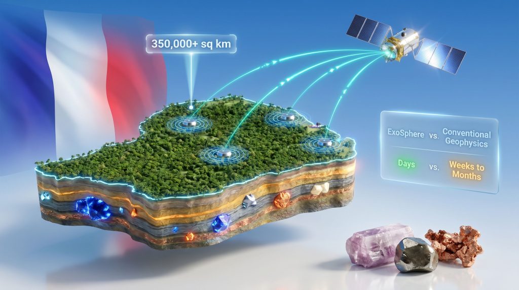
Fleet Space Technologies' ExoSphere platform is not a single technology but an integrated architecture combining four distinct capability layers. Understanding how these layers interact is essential to appreciating why this system is particularly suited to French Guiana's exploration challenge.
Layer One: The Geode Sensor Network
The foundation of ExoSphere is the Geode, a hand-portable, wireless, battery-powered geophysical sensor that requires no cable infrastructure for deployment. Traditional seismic and geophysical arrays rely on extensive ground-level cabling to network sensors, requiring precise grid setup and substantial crew time. In jungle terrain, this approach is not merely inconvenient; it is often impossible without clearing vegetation at a scale that would breach environmental permits.
Geodes eliminate this constraint entirely. Each sensor contains built-in edge computing capability, allowing it to pre-process raw geophysical data at the point of collection before transmission. This reduces data volume and accelerates the pipeline from acquisition to interpretation.
Layer Two: The LEO Satellite Constellation
Fleet Space operates a proprietary constellation of more than 10 low-Earth orbit satellites that receive data transmitted directly from deployed Geodes. In conventional surveys, field crews must physically retrieve sensors and download data after each survey cycle, a process that can extend total project timelines by weeks. Satellite connectivity eliminates this retrieval bottleneck entirely, compressing the period between data acquisition and geological interpretation from months to days.
Layer Three: AI-Driven Subsurface Analytics
Raw geophysical data has limited value without interpretation. ExoSphere's third layer applies machine learning models to passive seismic datasets, ambient noise tomography, and multi-method geophysical inputs to generate three-dimensional subsurface structural models. Furthermore, AI in mineral exploration identifies potential ore body geometries, stratigraphic contacts, and structural corridors that focus mineralisation. Fleet Space has applied this system across more than 350,000 square kilometres globally, building a training dataset that improves model performance with each new deployment.
Layer Four: Quantum and Muon-Based Sensing Integration
This is perhaps the least widely understood aspect of the ExoSphere platform. Through partnerships with specialist technology providers including mDetect, Nomad Atomics, and DeteQt, Fleet Space is integrating quantum gravimetry and muon tomography into the exploration workflow.
- Quantum gravimetry measures minute variations in the Earth's gravitational field with exceptional precision, detecting the density contrasts that distinguish sulphide or oxide ore bodies from surrounding country rock
- Muon tomography uses cosmic ray particles that penetrate hundreds of metres of rock to image subsurface density structures non-invasively, providing resolution at depths where conventional seismic methods become less reliable
These methods extend effective imaging depth and resolution beyond what passive seismic alone can achieve, which is critical for detecting concealed deep deposits beneath thick tropical weathering profiles.
Comparative Performance: ExoSphere vs. Conventional Methods
| Capability Dimension | Conventional Geophysics | Fleet Space ExoSphere |
|---|---|---|
| Sensor deployment | Cable-networked, grid-dependent | Wireless, cable-free |
| Data retrieval | Physical field crew download | Real-time satellite transmission |
| Environmental footprint | High (ground disturbance, cabling) | Low (portable, no infrastructure) |
| Time from acquisition to interpretation | Weeks to months | Days |
| Subsurface imaging depth | Variable, method-dependent | Surface to 1,000+ metres |
| Terrain suitability | Limited in jungle environments | Optimised for frontier terrain |
| AI integration | Limited post-processing | Native AI analytics layer |
Survey Methodology: What Is Actually Happening in the Northern Furrow
The Phase 1 survey program operating under a strict no-drilling, no-deforestation constraint combines multiple non-intrusive methods to build a comprehensive picture of subsurface geology.
Airborne geophysical surveys using helicopter and fixed-wing platforms collect magnetic, radiometric, and electromagnetic data across the priority corridor, imaging geology from near-surface to depths exceeding 1,000 metres without any ground contact.
Passive seismic and ambient noise tomography deploy Geode sensors to record naturally occurring seismic energy from background sources including ocean microseisms, atmospheric loading, and human activity. By analysing how this ambient energy travels through different rock types, geophysicists construct velocity models that reveal subsurface stratigraphy and structure without requiring any active seismic source such as explosives or vibroseis trucks.
Sediment geochemistry samples river sediments to identify geochemical anomalies that indicate upstream mineralisation. Because rivers integrate material from large catchment areas, anomalous metal concentrations in stream sediments can identify prospective source zones that are then prioritised for more detailed geophysical follow-up.
Quantum gravimetry and muon tomography are being integrated into the program as planned additions, providing an additional layer of subsurface imaging resolution for deep-seated targets.
This multi-method approach reflects an important principle in modern frontier exploration: no single geophysical technique provides a complete picture of the subsurface. Combining methods with different physical sensitivities and depth ranges produces a more robust and reliable geological model than any individual dataset alone.
The Institutional Credibility Behind Fleet Space's Involvement
Fleet Space's selection through BRGM's 2025 Geophysics Innovation Challenge was not incidental. The challenge was structured as a competitive procurement process specifically designed to identify next-generation, low-impact exploration methodologies, meaning the ExoSphere platform was evaluated against alternatives before the MOU was formalised.
The company's operational credentials support this selection:
- A$50 million raised in a Series C funding round supporting global expansion with a North American focus
- More than 350,000 sq km of terrain mapped using the ExoSphere platform across multiple continents
- Strategic clients including Rio Tinto and Barrick Gold among 30+ active operators globally
- Acquisition of HiSeis, integrating high-resolution seismic exploration technology and expanding data capacity to exabyte scale
- CEO Flavia Tata Nardini has led the company's convergence of space infrastructure, AI analytics, and geoscience into a unified exploration product
The MOU itself is structured as a co-development framework rather than a straightforward technology supply arrangement. BRGM contributes decades of expertise in geological mapping, geophysics, and mineral system analysis, while Fleet Space contributes its satellite infrastructure, sensor network, and AI interpretation capabilities. The intent is to produce methods that neither party could develop independently within the same timeframe.
Strategic framing: BRGM has explicitly stated that the goal of this partnership extends beyond French Guiana. The objective is to develop scalable exploration methodologies that can be applied to any remote, ecologically sensitive, or frontier geological environment globally, positioning the outputs of this program as reusable sovereign geoscience infrastructure.
The next major ASX story will hit our subscribers first
Environmental Integrity as a Design Requirement, Not an Afterthought
French Guiana hosts one of the most biodiverse tropical ecosystems on Earth. A substantial portion of the territory falls under French and EU environmental protections, and indigenous land rights create additional constraints on exploration activity that would cause surface disturbance.
The environmental footprint comparison across exploration methodologies illustrates why low-impact technology selection matters:
| Methodology | Surface Disturbance | Vegetation Impact | Noise/Vibration | Waste Generation |
|---|---|---|---|---|
| Cable-grid seismic survey | High | Moderate-High | High | Moderate |
| Drill-based sampling | High | High | Moderate | High |
| Airborne geophysical survey | Minimal | None | Low | None |
| ExoSphere passive seismic | Minimal | None | None | None |
| Muon tomography | None | None | None | None |
The no-drilling, no-deforestation constraint on Phase 1 is not simply a public relations position. It reflects the genuine operational reality that gaining access to French Guiana's most ecologically sensitive prospective areas requires a methodological approach that regulators and communities can accept. Low-impact geophysics is not merely more sustainable; in environments like this, it is the only viable path to systematic mineral inventory.
Broader Implications for Europe's Critical Mineral Strategy
The Fleet Space and BRGM French Guiana critical mineral exploration initiative sits within a larger strategic context that extends well beyond the territory's borders. Europe has mobilised more than USD $30 billion in critical mineral supply chain resilience programs as it confronts the reality that clean energy and advanced manufacturing depend on raw materials it currently cannot source domestically in sufficient quantities.
Niobium provides a useful illustration. The world's niobium supply is dominated overwhelmingly by a single country, Brazil, with over 90% of global production concentrated there. Furthermore, the critical minerals demand for niobium from Europe's industrial base — which depends on it for high-strength steel used in automotive and aerospace manufacturing — has essentially no sovereign supply alternative. French Guiana's confirmed niobium occurrences, if they can be characterised at scale, represent a meaningful contribution to European supply chain diversification within the EU's own territorial boundaries.
The same logic applies to tantalum, where global supply is concentrated in a handful of jurisdictions, several of which carry elevated political risk. Consequently, processing critical minerals sourced from EU territory becomes a strategic priority for reducing dependence on Australian and South American imports processed through Chinese supply chains.
Investor note: This article contains forward-looking assessments of mineral prospectivity and strategic resource significance. Confirmed mineral occurrences do not imply economic resources or mineral reserves. Readers should not interpret geological prospectivity assessments as indicative of future project development, production, or commercial outcomes. All investment decisions should be made with appropriate professional advice.
What a Successful Program Could Unlock Beyond French Guiana
The methodological innovations developed under the BRGM-Fleet Space partnership have potential applications far beyond this single territory. Sovereign geoscience programs in Southeast Asia, Central Africa, and the Pacific Islands face structurally identical challenges: high ecological sensitivity, limited infrastructure, tropical terrain, and a critical need to inventory mineral potential without triggering community or regulatory opposition through disruptive conventional methods.
However, the critical minerals geopolitics surrounding frontier exploration adds another dimension to why this program matters. If ExoSphere-enabled surveys successfully characterise the northern furrow's mineral architecture, the validated methodology becomes a deployable blueprint. This is the scalability thesis that makes the program strategically significant for Fleet Space beyond its immediate commercial scope, and it is why BRGM framed the partnership as a co-development initiative rather than a procurement contract.
The convergence of space infrastructure, quantum sensing, AI analytics, and passive geophysics is not just a technical evolution in mineral exploration. It is the foundation of a new paradigm in which sovereign nations can systematically understand what lies beneath their most difficult terrain without compromising the environmental and social values that make that terrain worth protecting in the first place.
Want to Know When the Next Major Mineral Discovery Hits the ASX?
Discovery Alert's proprietary Discovery IQ model scans ASX announcements in real time, instantly alerting subscribers to significant mineral discoveries — including those tied to critical minerals driving Europe's supply chain transformation — and turning complex geological data into actionable investment insights. Explore how historic discoveries have generated exceptional returns on Discovery Alert's discoveries page, and begin your 14-day free trial today to position yourself ahead of the broader market.