June 10, 2026
The Hidden Productivity Crisis in Mineral Exploration
Across the global mining sector, a quiet but enormously costly inefficiency has persisted for decades. Exploration companies collectively spend billions of dollars each year generating geological data, yet a significant portion of that knowledge becomes effectively inaccessible almost as soon as it is produced. Scanned field reports, analogue borehole records, legacy seismic profiles, and historical presentations pile up in fragmented digital archives, largely invisible to modern analytical tools and unreachable without sustained manual effort.
This is not a marginal problem. For junior explorers operating on tight budgets and compressed timelines, the inability to rapidly query historical subsurface data can mean the difference between identifying a promising target early and arriving late to a well-understood geological corridor. For major resource companies building AI-driven mining workflows, the quality of data inputs directly determines the predictive power of their models. In both cases, the bottleneck is the same: the gap between raw geological archives and actionable, machine-readable intelligence.
The GeoClerk API for geoscience research represents a direct attempt to close that gap, and understanding why it matters requires looking at both the scale of the problem it addresses and the technical architecture it deploys to solve it.
When big ASX news breaks, our subscribers know first
Understanding the Scale of Geoscience's Data Accessibility Problem
Why Historical Geological Archives Are Structurally Inaccessible
Most geological data exists in formats that were never designed for programmatic retrieval. Decades of exploration activity have produced enormous libraries of documents where critical subsurface information is embedded in images rather than text. A stratigraphic column inside a scanned PDF, for example, carries no searchable metadata. A seismic cross-section reproduced in a 1990s exploration report cannot be indexed by a conventional keyword search engine. A well log reproduced as a raster image is, to most database systems, simply a picture.
This creates a structural asymmetry: the information exists, but the infrastructure to surface it at scale does not. Analysts working without purpose-built tools must manually navigate archives, open individual documents, assess visual content by eye, and compile findings by hand. Depending on the scope of a literature review, this process can consume days or weeks of skilled geoscientist time before any meaningful interpretation begins.
The consequences extend beyond individual productivity. At an industry level, this dynamic means that knowledge generated through past drilling campaigns, geophysical surveys, and regional mapping programs remains systematically underutilised. Each new generation of explorers partially rediscovers what previous programs already documented, not through ignorance, but because the retrieval infrastructure necessary to surface that prior knowledge efficiently does not exist in most organisations.
The Broader Digital Transformation Context
It is worth noting that geoscience is not uniquely resistant to digital transformation. Finance, life sciences, legal research, and energy have all confronted similar challenges around unstructured legacy data, and each has benefited substantially from API-driven, machine-learning-assisted access to previously siloed archives. In financial services, the transition from manual document review to programmatic data retrieval contributed to substantial reductions in analyst preparation time and enabled entirely new categories of quantitative research.
Geoscience is now at a comparable inflection point, and the technical foundations that enable this transition are considerably more mature than they were even five years ago. Advances in computer vision, optical character recognition, and multi-modal machine learning have made it possible to extract and classify geological content from unstructured sources with a degree of accuracy that was previously unattainable at commercial scale.
What GeoClerk Is and How the Platform Was Built
GeoClerk's Role Within the Searcher Ecosystem
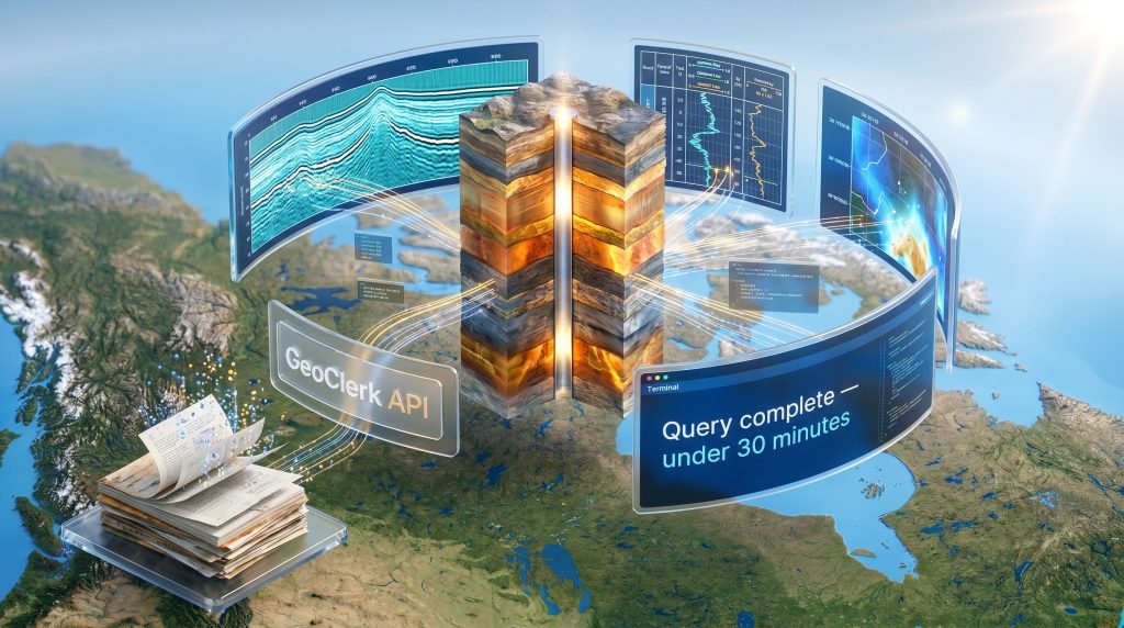
GeoClerk operates as a subsidiary of Searcher, a global solutions provider with a mandate spanning geospatial and subsurface data services. The platform was originally developed as a geo-imagery search engine, applying machine learning to locate, classify, and retrieve geological imagery embedded within reports, presentations, and historical scanned documents.
Over successive development cycles, the platform's capabilities expanded considerably. Full-text search, georeferencing functionality, and structured filtering tools were added to what began as an image retrieval system. The launch of the GeoClerk API represents the most significant capability extension to date, transforming the platform from a search interface into programmable research infrastructure.
The Machine Learning Architecture Behind the Search Engine
At a technical level, GeoClerk's differentiation rests on its ability to treat geological imagery and surrounding textual content as linked, jointly searchable objects. Rather than indexing documents solely through their metadata or readable text, the platform's ML engine classifies visual content within documents and associates it with contextual information such as location references, formation names, and document provenance.
This multi-modal approach enables retrieval queries that conventional geological databases cannot replicate. A user searching for seismic profiles from a specific basin, for example, can retrieve relevant imagery regardless of whether those images appear in well-formatted digital reports or degraded scanned documents from the 1970s.
The range of geological content types the system can identify and index includes:
- Seismic profiles and interpreted cross-sections
- Well logs and borehole completion records
- Stratigraphic columns and lithostratigraphic maps
- Formation contact diagrams and structural geology figures
- Full exploration reports, technical memoranda, and conference presentations
Technical Note: GeoClerk's ability to extract usable geological intelligence from unstructured and semi-structured sources is particularly significant for archives predating the widespread adoption of digital reporting standards. Much of the most geologically valuable exploration data in existence was generated before consistent digital formatting was industry practice.
What the GeoClerk API Actually Delivers
Core Capabilities and Functional Architecture
The GeoClerk API provides programmatic access to the platform's exploration corpus, enabling developers and geoscientists to embed search functionality directly into custom tools, automated pipelines, and AI agent systems. According to GeoClerk, the API supports four primary functional categories:
| Capability | Operational Description |
|---|---|
| Direct geological record search | Query the corpus by geographic location, keyword, or imagery classification without manual platform navigation |
| Automated repetitive query execution | Execute high-volume or recurring search tasks in the background without analyst involvement at each step |
| Internal newsletter population | Automatically surface and compile topically relevant geological content for distribution within research organisations |
| Data screening and filtering | Apply structured criteria across large document sets to isolate relevant findings systematically |
Search Parameter Architecture
The API's query framework supports multiple search modalities that can be combined for precision targeting:
- Geographic coordinate or basin-level location queries
- Keyword and semantic text search across full document bodies
- Image-type classification filters, allowing users to specify seismic profiles, well logs, maps, or cross-sections
- Multi-parameter combinations that triangulate across location, content type, and textual context simultaneously
This multi-modal query capability is what separates the GeoClerk API for geoscience research from conventional geological databases, which typically require data to be pre-formatted and indexed through standardised metadata schemas before it becomes retrievable.
AI Agent Integration: The Forward-Looking Architecture
Perhaps the most strategically significant characteristic of the GeoClerk API is its explicit design for integration with autonomous AI agent workflows. Rather than functioning solely as a developer utility for building search interfaces, the API is architected to serve as a data retrieval layer within fully automated research pipelines.
In practical terms, this means AI agents can be configured to independently query geological archives, retrieve and classify relevant documents, and feed structured outputs into downstream interpretation or modelling tools without human intervention at each step of the process.
Tim Hall-Johnston, Head of Product at GeoClerk, has described the platform's fundamental value as converting a vast, disorganised geological archive into something that can be searched within seconds by place, by keyword, or by image type. The API extends that capability directly into code and AI agent environments, enabling research tasks that previously consumed an analyst's full working week to run autonomously in the background in a matter of minutes. (Canadian Mining Journal, June 2026)
The Productivity Mathematics of Programmatic Geoscience Research
A Practical Scenario: Basin-Wide Literature Review
The productivity implications of API-driven geoscience research become clearest when examined through a concrete operational scenario.
Scenario: A junior exploration company needs to conduct a basin-wide literature review spanning 15 years of historical drilling reports and geophysical surveys across a prospective copper-gold corridor.
Without the GeoClerk API:
A geoscience analyst manually queries multiple database interfaces, downloads and reviews individual documents, manually extracts and catalogues relevant imagery, cross-references location data, and compiles findings into a usable format. Estimated elapsed time: 4 to 7 full working days.
With the GeoClerk API integrated into an AI workflow:
Automated queries retrieve, classify, and compile relevant records across the entire archive. Active setup time: under 30 minutes. Background execution time for a comprehensive result set: a matter of hours.
The productivity differential described here is not incremental improvement. It is a structural change in the economics of exploration due diligence. Tasks that required a skilled analyst's full attention for the better part of a working week become background processes. That reallocation of expert time has compounding value across an exploration program.
Broader Industry Implications
The ripple effects of programmatic geoscience data access extend well beyond individual analyst productivity. Furthermore, interpreting drill results becomes considerably more efficient when historical context is rapidly retrievable rather than manually compiled. The key implications include:
- Expanded geographic screening: Exploration teams can evaluate larger areas and higher document volumes before committing capital to fieldwork, improving the ratio of informed decisions to speculative ones.
- Legacy data reclamation: Decades of historical drilling and survey programs, much of which exists only in scanned PDFs or analogue documents, becomes systematically accessible rather than functionally lost.
- Competitive basin intelligence: Companies can monitor geological activity and published findings across entire jurisdictions programmatically, rather than relying on periodic manual literature reviews that inevitably miss recent developments.
- AI model training inputs: High-quality, classified geological imagery and structured text extracted through the API can serve directly as training data for proprietary machine learning models targeting mineralisation prediction or structural geology interpretation.
How the GeoClerk API Compares to Conventional Geoscience Databases
Feature-Level Comparison
| Feature | GeoClerk API | Traditional Geoscience Databases |
|---|---|---|
| Search modality | Text, image, and location combined | Primarily metadata or text-based |
| Legacy document handling | ML extraction from unstructured and scanned files | Limited; typically requires pre-formatted data |
| Programmatic access | Full API with AI-agent architecture | Often absent or severely restricted |
| Automation capability | Background execution, newsletter population | Manual query-response model |
| Data types supported | Seismic, logs, maps, cross-sections, reports | Often siloed by data type or format |
| AI workflow integration | Purpose-built for autonomous agent deployment | Not natively designed for AI pipelines |
| Access pathways | New subscriptions and add-on for existing users | Typically standalone subscription models |
The comparison above highlights a critical distinction: GeoClerk is not simply a better version of existing geological databases. It represents a different category of tool. Where conventional databases require data to conform to their structure, GeoClerk's ML extraction layer works with data in its native, often messy, real-world condition.
The next major ASX story will hit our subscribers first
Who the GeoClerk API Is Designed For
Access Structure and Target User Profiles
The API is available through two pathways. New subscribers to the GeoClerk platform can elect API access during onboarding, while existing users can add programmatic access as a supplementary feature without migrating to a new service tier. This structure reflects a deliberate approach to expanding platform utility while maintaining continuity for the existing user base.
The primary user profiles for whom the API delivers the most direct value include:
- Exploration geoscientists conducting basin-scale or project-specific literature reviews who need to process large document volumes efficiently.
- Data scientists and machine learning engineers building geological AI systems that require structured, classified training data from real-world exploration archives.
- Research institutions and university geoscience departments seeking programmatic access to subsurface exploration data for academic research programs.
- Junior and mid-tier mining companies looking to accelerate early-stage target generation without proportionally increasing headcount or operational overhead.
- Technical analysts at major resource companies integrating geoscience data into broader digital intelligence and predictive modelling platforms.
Note for Developers and Research Teams: Specific technical documentation covering API endpoints, authentication protocols, rate limits, and commercial pricing should be confirmed directly through GeoClerk's official product channels, as these parameters are subject to revision and had not been comprehensively standardised in publicly available documentation at the time of writing.
Three Macro Forces Driving Demand for Programmatic Geoscience Data
The Technology Convergence Reshaping Exploration Infrastructure
The launch of the GeoClerk API does not occur in isolation. It reflects three converging macro trends that are collectively reshaping how exploration data is generated, stored, and consumed.
1. The AI Readiness Imperative
As mining and energy companies invest in AI in mineral exploration, the quality and accessibility of data inputs becomes a defining competitive variable. Organisations whose data infrastructure produces AI-ready outputs will generate better model performance than those whose archives remain locked in legacy formats. Platforms that deliver structured, programmatically accessible geological intelligence are increasingly positioned as strategic infrastructure rather than optional analytical tools.
2. The Legacy Data Reclamation Movement
The global exploration industry has collectively generated an enormous volume of subsurface knowledge over the past century, and the majority of it remains underutilised. A growing cohort of mining technology companies is now building specifically to reclaim this historical knowledge base, recognising that the cost of unlocking existing data is typically far lower than the cost of generating equivalent new data through fieldwork.
3. The Automation of Knowledge Work in Technical Disciplines
Across engineering, legal research, financial analysis, and life sciences, the automation of repetitive cognitive tasks is accelerating rapidly. Geoscience has lagged behind these adjacent fields partly due to the visual, unstructured nature of its core information assets. Purpose-built ML extraction tools are now closing that gap, and the profession's relationship with systematic literature compilation is beginning to change fundamentally.
Where GeoClerk Sits in the Exploration Technology Stack
Within the broader architecture of a modern exploration technology programme, GeoClerk occupies the data discovery and retrieval layer. This sits upstream of interpretation platforms, 3D geological modelling software, and AI targeting systems. Its function is to ensure that the raw geological intelligence feeding those downstream tools is as comprehensive, structured, and current as possible.
As exploration workflows become more tightly integrated and increasingly dependent on machine learning, the quality of this upstream data layer becomes a primary determinant of overall programme performance. Poor retrieval infrastructure propagates gaps and biases throughout every downstream analysis that depends on it. Consequently, tools such as downhole geophysics platforms that rely on well-organised input data stand to benefit considerably from improved upstream retrieval infrastructure.
Frequently Asked Questions: GeoClerk API for Geoscience Research
What geological content types can the API retrieve?
The API provides access to seismic profiles, well logs, stratigraphic records, geological maps, cross-sections, and full-text exploration reports. Its ML classification system enables retrieval by geographic location, keyword, or imagery type across structured and unstructured document sources.
Is the API designed for AI and machine learning workflows?
Yes. The API is explicitly architected for AI-agent compatibility, enabling autonomous query execution within automated research pipelines. It is well-suited to teams building ML models requiring classified geological training data, as well as organisations deploying AI agents to conduct background research at scale.
How does GeoClerk handle scanned or analogue documents?
The platform's ML engine is specifically built to extract and classify content from unstructured sources, including scanned historical reports, legacy PDFs, and older exploration presentations. These document types are typically invisible to conventional keyword-based database systems.
What is the relationship between GeoClerk and Searcher?
GeoClerk is a subsidiary of Searcher, a global solutions provider with a broader mandate in geospatial and subsurface data services. The parent company's organisational infrastructure and market reach provide GeoClerk with resources beyond those typically available to standalone geoscience search platforms.
Key Takeaways for Exploration Professionals and Technology Investors
The GeoClerk API for geoscience research represents a meaningful infrastructure advancement for the sector, addressing a structural inefficiency that has constrained exploration productivity for decades. Several conclusions emerge for different stakeholder groups:
- For exploration companies, programmatic access to historical geological archives reduces the time and cost of early-stage due diligence while increasing the comprehensiveness of coverage before capital commitment decisions are made.
- For data scientists and ML engineers, a purpose-built geological API with AI-agent compatibility reduces the data preparation burden for building domain-specific models and accelerates the pipeline from raw archive to structured training set.
- For research institutions, programmatic access enables systematic, reproducible literature reviews at scales that were previously impractical within typical project timelines and resource constraints.
- For technology observers, GeoClerk's evolution from an imagery search engine to programmable AI-compatible infrastructure illustrates a broader pattern: domain-specific data platforms that survive and scale are those that successfully transition from being tools researchers use to being infrastructure researchers build upon.
This article contains forward-looking assessments of technology capabilities and market trends. Readers should independently verify platform specifications, pricing, and operational parameters directly with GeoClerk before making procurement or investment decisions. Technology performance in real-world deployment conditions may differ from scenarios described for illustrative purposes.
Want to Know Which ASX Explorers Are Making Significant Mineral Discoveries Right Now?
Discovery Alert's proprietary Discovery IQ model scans ASX announcements in real time, instantly converting complex geological and commodity data across more than 30 resources into a single, actionable gold-equivalent metric — so whether you're evaluating early-stage exploration opportunities or tracking transformative discoveries like those made by De Grey Mining and WA1 Resources, you can act before the broader market catches on. Start your 14-day free trial today and see why serious investors rely on Discovery Alert's discoveries page to understand the historic returns that significant mineral finds can generate.