June 29, 2026
What Are Geological Maps and Why Does Rondônia Matter for Mineral Exploration?
Understanding geological formations requires sophisticated mapping systems that document rock types, ages, and mineral associations across vast territories. Modern geological surveys serve as the foundation for mineral exploration insights, infrastructure planning, and environmental assessment throughout Brazil's diverse geological provinces.
Defining Geological Mapping Standards and Scale Classifications
Geological mapping operates through hierarchical scale systems that progressively refine regional understanding. The Brazilian Geological Survey (SGB) employs standardized methodologies beginning with state-wide overviews at 1:500,000 scale, followed by detailed regional documentation at 1:100,000 scale for specific zones of interest.
Scale Comparison Framework:
| Scale | Coverage Area | Detail Level | Primary Applications |
|---|---|---|---|
| 1:500,000 | State-wide | Regional overview | Strategic planning |
| 1:100,000 | Local sheets | Detailed formations | Exploration targeting |
| 1:50,000 | Specific zones | High-resolution | Mine development |
The progression from broad regional frameworks to focused geological documentation enables exploration professionals to identify prospective terrains before committing resources to property-level investigations. This systematic approach has proven essential for understanding complex geological relationships across Brazil's Precambrian basement terrains.
Rondônia's Strategic Position in Brazil's Mineral Resource Portfolio
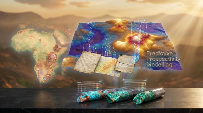
Rondônia demonstrates exceptional geological diversity through rocks representing different geological environments and spanning multiple age periods. This diversity creates favorable conditions for hosting economically significant mineral resources across metallic, industrial, and gemstone categories.
The state's mineral endowment includes primary commodities such as tin, gold, copper, manganese, and iron, alongside valuable gemstones including diamond, topaz, amethyst, tourmaline, and aquamarine. Industrial applications are supported through sand, gravel, clay, and aggregate resources, while agricultural sectors benefit from limestone and phosphate deposits.
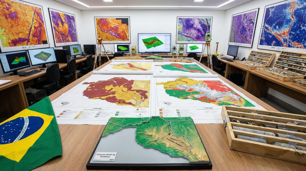
Recent SGB publications have enhanced understanding of these mineral systems through newly released geological maps of Rondônia at multiple scales. The 1:500,000 scale explanatory note published in 2025 provided state-wide geological context, followed by detailed 1:100,000 scale sheets for the Cacoal and Serra Azul regions in 2026.
The Amazonian Craton Foundation: Understanding Precambrian Geology
Precambrian basement complexes form the geological foundation supporting Rondônia's mineral potential. These ancient rock systems underwent multiple deformation, metamorphic, and mineralization episodes that created diverse deposit styles across the region.
The interaction between Precambrian basement architecture and younger geological processes established conditions for both primary mineralization in bedrock systems and secondary accumulations through weathering and erosion. This dual character explains the presence of both hard-rock mining opportunities and alluvial mineral concentrations throughout the state.
When big ASX news breaks, our subscribers know first
How Do Modern Geological Surveys Transform Regional Mineral Discovery?
Contemporary geological survey methodology integrates traditional field mapping with advanced analytical techniques to produce comprehensive documentation of regional mineral potential. Furthermore, the Brazilian approach emphasizes progressive scale refinement and open data access to maximize exploration efficiency.
Advanced Mapping Methodologies: From Field Studies to Digital Integration
Modern geological mapping combines systematic field observation with digital documentation systems that ensure data consistency and accessibility. The SGB's approach integrates multiple data streams to produce authoritative geological products for public use.
Key methodological components include:
- Systematic field mapping protocols ensuring consistent data collection
- Digital documentation systems supporting long-term data preservation
- Multi-scale integration enabling regional to local geological analysis
- Quality control procedures maintaining scientific accuracy
The "Geology and Mineral Potential of Central-East Rondônia" project demonstrates this integrated approach through coordinated mapping of specific geographic zones using standardized methodologies developed at the national level.
Scale Hierarchies in Geological Documentation (1:500,000 vs 1:100,000)
Hierarchical mapping strategies enable users to navigate from broad regional contexts to detailed formation-level analysis. In addition, the SGB's sequential release of products supports this progressive understanding through complementary documentation at different scales.
Scale-specific applications:
- 1:500,000 products establish regional geological frameworks and identify broad mineral trends
- 1:100,000 sheets provide formation-level detail supporting targeted exploration programs
- Detailed scales enable property-level analysis for specific development projects
The Cacoal and Serra Azul sheets represent initial phases of detailed mapping for central-east Rondônia, with additional sheets anticipated as the regional program continues.
Lithostratigraphic Analysis Techniques for Complex Terrains
Complex geological terrains require sophisticated analytical approaches to understand rock relationships and mineralization controls. Brazilian geological surveys employ standardized lithostratigraphic classification systems that enable consistent documentation across different regions.
These techniques prove particularly valuable in Precambrian terrains where multiple deformation episodes have modified original rock relationships. 3D geological modelling enables recognition of regional patterns that guide mineral exploration strategies.
What Mineral Resources Drive Geological Interest in Rondônia?
Rondônia's geological diversity supports an exceptional range of mineral commodities spanning metallic resources, industrial applications, and gemstone production. However, understanding this mineral endowment requires analysis of the geological processes that created different deposit types.
Primary Economic Minerals: Tin, Gold, and Base Metal Distributions
Metallic commodities form the foundation of Rondônia's mineral economy through primary deposits hosted in Precambrian basement rocks and secondary concentrations in younger geological systems.
Major metallic resources include:
- Tin (estanho) – Primary commodity with significant regional production history
- Gold (ouro) – Present in both bedrock and alluvial systems
- Copper (cobre) – Associated with specific geological formations
- Manganese (manganês) – Supporting industrial applications
- Iron (ferro) – Available for potential large-scale development
The distribution of these commodities reflects different geological environments and mineralization processes, requiring detailed geological maps of Rondônia to understand exploration potential.
Gemstone Provinces: Diamond, Topaz, and Tourmaline Occurrences
Rondônia's gemstone endowment demonstrates the diversity of mineralizing conditions present throughout the state's geological history. Multiple gemstone types indicate varied pressure, temperature, and chemical conditions during formation.
Documented gemstone resources:
- Diamond (diamante) – High-value gemstone requiring specific geological conditions
- Topaz (topázio) – Associated with particular igneous and metamorphic environments
- Amethyst (ametista) – Quartz variety formed through hydrothermal processes
- Tourmaline (turmalina) – Complex borosilicate indicating specialized chemical conditions
- Aquamarine (água-marinha) – Beryl variety requiring specific geological settings
Additionally, graphite (grafita) is documented among mineral resources, though its classification alongside gemstones suggests potential for high-grade crystalline varieties with industrial applications.
Industrial Minerals and Agricultural Input Resources
Industrial and agricultural applications require substantial mineral inputs that Rondônia provides through diverse geological formations. These resources support both regional development and export opportunities.
Industrial mineral resources:
- Sand (areia) and gravel/aggregate (brita, cascalho) – Construction industry inputs
- Clay (argila) – Ceramic and construction applications
Agricultural input materials:
- Limestone (calcário) – Soil pH adjustment and cement production
- Phosphate (fosfato) – Essential fertilizer component
The geological diversity of Rondônia creates multiple pathways for mineral formation, from primary crystallization in igneous systems to secondary concentration through weathering and sedimentary processes.
How Are Digital Geological Resources Accessed and Utilised?
Digital access to geological information has transformed mineral exploration by eliminating cost barriers and providing standardized data formats for professional analysis. Consequently, the Brazilian Geological Survey has prioritised open access through institutional repository systems.
The RiGeo Repository System: Navigation and Data Extraction
The Repositório Institucional de Geociências (RiGeo) serves as the primary portal for accessing SGB geological publications without cost restrictions. This system employs persistent identifiers and standardised documentation formats to ensure long-term data accessibility.
RiGeo system specifications:
- Homepage access: https://rigeo.sgb.gov.br/home
- Document organisation: Hierarchical by scale, region, and commodity type
- Persistent identifiers: Handle-based URLs ensuring stable long-term access
- Cost structure: All publications available freely (gratuitamente)
Currently available Rondônia geological products:
- State overview: 1:500,000 scale explanatory note
- Cacoal sheet: 1:100,000 scale detailed mapping
- Serra Azul sheet: 1:100,000 scale regional documentation (accessible through RiGeo)
Geobank Database Integration for Professional Applications
Professional geological analysis requires integration of multiple data sources beyond basic mapping products. For instance, the SGB's digital infrastructure supports comprehensive geological assessment through coordinated database systems.
Database integration capabilities include:
- Cross-referencing geological maps with geochemical data
- Structural geology analysis using multiple information layers
- Mineral occurrence databases supporting exploration targeting
- Historical geological data providing temporal context
Open-Source Geological Data: Opportunities and Limitations
Open access geological data democratises mineral exploration by removing financial barriers for small exploration companies, academic institutions, and government agencies. This policy approach reflects Brazilian commitment to transparent geological information sharing.
Opportunities provided through open access:
- Reduced exploration costs during preliminary assessment phases
- Standardised data formats enabling systematic regional analysis
- Educational applications supporting geological training programmes
- Government planning applications for infrastructure development
Considerations for data utilisation:
- Map scale limitations requiring field verification for detailed applications
- Update frequencies may not reflect recent exploration discoveries
- Data interpretation requires professional geological expertise
- Integration with proprietary datasets may require additional processing
Which Specific Geological Formations Define Rondônia's Mineral Potential?
Understanding specific geological formations requires access to detailed mapping products that document lithological units, structural relationships, and mineralisation associations. The newly published Cacoal and Serra Azul sheets provide formation-level detail for specific geographic zones.
Serra da Providência Complex: Structural Controls on Mineralisation
Precambrian basement complexes typically exhibit structural controls on mineral emplacement through fracture systems, metamorphic zones, and contact relationships. These features require detailed geological maps of Rondônia to understand their influence on mineral distribution.
Analysis considerations for basement complexes:
- Structural orientation and timing relationships
- Metamorphic grade variations affecting mineral stability
- Contact relationships with younger geological units
- Hydrothermal alteration patterns indicating fluid flow
Colorado Graben System: Copper-Bearing Formations
Graben systems represent extensional geological environments that can concentrate mineral-bearing fluids through focused structural controls. Understanding these systems requires analysis of both structural geometry and associated lithological units.
Graben-related mineralisation factors:
- Structural controls on fluid flow and mineral deposition
- Sedimentary or volcanic fill sequences hosting mineralisation
- Contact relationships between graben fill and basement rocks
- Secondary mineral concentrations through weathering processes
Ariquemes Region: Gamma-Spectrometry Mapping Results
Geophysical surveys complement traditional geological mapping by providing information about subsurface geological characteristics. Gamma-spectrometry proves particularly valuable for identifying lithological variations and alteration zones.
Geophysical mapping applications:
- Lithological discrimination through radiometric signatures
- Alteration zone identification supporting exploration targeting
- Structural feature recognition through geophysical contrasts
- Regional geological continuity analysis
Note: Detailed formation descriptions and specific geological relationships require consultation of the published Cacoal and Serra Azul geological sheets through the RiGeo repository system.
What Role Does Airborne Geophysics Play in Regional Geological Mapping?
Airborne geophysical surveys provide cost-effective regional coverage that complements traditional field mapping techniques. These methods prove particularly valuable in areas with limited surface exposure or difficult access conditions.
Gamma-Spectrometry Applications for Lithological Discrimination
Gamma-ray spectrometry measures natural radioactivity in rocks, enabling discrimination between different lithological units based on their potassium, thorium, and uranium content. This technique supports regional geological mapping by identifying major rock units and alteration zones.
Gamma-spectrometry capabilities:
- Potassium mapping – Identifies feldspathic rocks and alteration zones
- Thorium signatures – Discriminates between different igneous rock types
- Uranium anomalies – Indicates hydrothermal activity and specific mineral associations
- Radiometric ratios – Enhance lithological discrimination and alteration mapping
Magnetic Survey Integration with Traditional Field Mapping
Magnetic surveys detect variations in rock magnetic properties that correspond to different geological units and structural features. Integration with field mapping provides comprehensive understanding of regional geological relationships.
Magnetic survey applications:
- Basement structure mapping through magnetic contrasts
- Intrusive body delineation supporting mineral exploration
- Structural trend identification across covered terrain
- Regional geological continuity analysis
Hydrogeological Mapping Through Remote Sensing Techniques
Water resources and surface hydrology interact closely with geological structures and rock types. Remote sensing techniques provide regional information supporting both hydrogeological assessment and mineral exploration planning.
Remote sensing contributions to geological understanding:
- Surface geology mapping through spectral analysis
- Structural lineament identification using digital elevation models
- Vegetation patterns indicating subsurface geological conditions
- Surface water distribution reflecting geological controls
The next major ASX story will hit our subscribers first
How Do Geological Maps Support Investment Decision-Making?
Investment decisions in mineral exploration require comprehensive risk assessment based on geological, technical, and economic factors. Furthermore, quality geological mapping provides the foundation for evaluating mineral potential and exploration risk across different scales.
Risk Assessment Through Comprehensive Geological Understanding
Geological risk assessment requires analysis of multiple factors that influence exploration success probability. Comprehensive geological mapping enables systematic evaluation of these factors across regional and property scales.
Key risk assessment factors:
- Geological favourability – Rock types and structures supporting mineralisation
- Exploration maturity – Level of previous geological investigation
- Access conditions – Infrastructure and permitting considerations
- Scale potential – Geological evidence supporting economic mineral concentrations
Exploration Targeting Using Multi-Scale Geological Data
Effective exploration targeting integrates geological information at multiple scales to identify areas with highest mineral potential. This systematic approach optimises exploration expenditure by focusing efforts on geologically favourable terrains.
Multi-scale targeting methodology:
- Regional analysis – Identify favourable geological provinces using state-scale mapping
- District evaluation – Use detailed geological sheets to understand local geological controls
- Property assessment – Integrate geological mapping with downhole geophysics techniques and geochemical data
- Target generation – Define specific exploration targets based on integrated geological analysis
Infrastructure Planning and Environmental Considerations
Geological mapping supports infrastructure development and environmental assessment by providing essential information about ground conditions, natural hazards, and resource distribution. However, this information proves critical for sustainable development planning.
Infrastructure applications:
- Foundation design based on bedrock characteristics
- Route planning considering geological stability
- Resource assessment for construction materials
- Environmental baseline establishment for impact assessment
Comparison: Rondônia vs Other Brazilian Mining States
| State | Primary Commodities | Geological Complexity | Mapping Coverage |
|---|---|---|---|
| Rondônia | Tin, Gold, Gems | High (Precambrian) | Extensive |
| Minas Gerais | Iron, Gold, Gems | Very High | Complete |
| Pará | Iron, Copper, Gold | High | Ongoing |
What Are the Technical Specifications of Current Rondônia Geological Products?
Current geological products for Rondônia reflect systematic mapping methodology designed to provide comprehensive regional coverage through coordinated multi-scale documentation. Understanding technical specifications enables effective utilisation of these resources.
Cacoal Sheet Geological Characteristics and Coverage
The Cacoal sheet represents detailed 1:100,000 scale mapping for a specific geographic zone within central-east Rondônia. This product provides formation-level geological detail supporting targeted exploration and development activities.
Technical specifications:
- Scale: 1:100,000 providing detailed formation-level documentation
- Geographic coverage: Specific quadrangle within central-east Rondônia
- Data integration: Field mapping combined with geophysical and analytical data
- Access method: Permanent URL through RiGeo repository
Serra Azul Formation Mapping: Methodology and Results
The Serra Azul sheet complements Cacoal coverage by providing comparable detailed geological documentation for an adjacent geographic area. Together, these products establish comprehensive geological understanding for the central-east region.
Project methodology characteristics:
- Systematic field mapping following standardised SGB protocols
- Multi-disciplinary approach integrating geological, geophysical, and geochemical data
- Regional coordination ensuring consistency with broader mapping programmes
- Quality control through peer review and institutional validation processes
Quality Standards and Validation Processes
Brazilian geological survey products follow established quality standards ensuring scientific accuracy and professional applicability. The SGB employs multiple validation processes to maintain data integrity.
Quality assurance elements:
- Peer review processes ensuring scientific accuracy
- Institutional coordination maintaining methodological consistency
- Field validation confirming interpreted geological relationships
- Digital quality control verifying data integrity and accessibility
The "Geology and Mineral Potential of Central-East Rondônia" project was executed by the SGB's Porto Velho Residence with national coordination through the Department of Geology, demonstrating institutional commitment to quality geological documentation.
How Can Geological Maps Be Applied for Different User Categories?
Geological maps serve diverse user communities with varying requirements for detail, format, and application focus. Understanding these different applications enables effective utilisation of geological information across multiple sectors.
Academic Research Applications and Educational Resources
Academic institutions utilise geological maps for research programmes, student training, and collaborative projects with industry and government agencies. Open access through RiGeo supports educational applications without cost barriers.
Academic applications include:
- Research projects investigating regional geological processes
- Student training in geological interpretation and mapping techniques
- Collaborative programmes linking academic research with practical applications
- Reference materials supporting geological education and curriculum development
Mining Company Exploration Programmes
Mineral exploration companies require geological maps of Rondônia for target generation, risk assessment, and regulatory compliance. Multi-scale geological products enable progressive refinement from regional assessment to detailed property evaluation.
Exploration applications:
- Regional reconnaissance using state-scale geological frameworks
- Target generation through detailed geological sheet analysis
- Risk assessment based on geological favourability and exploration maturity
- Regulatory compliance demonstrating geological understanding for permitting applications
Government Planning and Environmental Assessment
Government agencies utilise geological information for infrastructure planning, environmental assessment, and resource management decisions. Comprehensive geological mapping supports evidence-based policy development and regulatory oversight.
Government applications:
- Infrastructure planning considering geological constraints and opportunities
- Environmental baseline establishment for impact assessment
- Resource management planning based on comprehensive geological understanding
- Regulatory oversight ensuring appropriate geological consideration in development projects
Frequently Asked Questions:
Q: Are Rondônia geological maps available for free download?
A: Yes, all SGB geological products for Rondônia are available without cost through the RiGeo repository system at rigeo.sgb.gov.br.
Q: What software is needed to work with digital geological data?
A: Digital geological maps typically require GIS software or PDF readers depending on format. Specific technical requirements are documented within individual product descriptions.
Q: How frequently are geological maps updated with new discoveries?
A: Update frequency depends on new geological investigation and resource availability. The SGB maintains institutional procedures for incorporating new geological information into published products.
What Future Developments Are Expected in Rondônia Geological Mapping?
Geological mapping continues evolving through technological advancement and expanded regional coverage. Future developments will likely integrate emerging analytical techniques with comprehensive regional documentation.
Emerging Technologies in Geological Survey Methods
Technological advancement continues transforming geological survey methodology through improved analytical capabilities, data integration systems, and field collection techniques. For instance, these developments enhance both efficiency and accuracy of geological documentation.
Emerging technological applications:
- Advanced spectroscopy enabling rapid mineral identification in field conditions
- Drone-based surveys providing high-resolution data for specific areas
- Machine learning supporting pattern recognition in large geological datasets
- Mobile computing enabling real-time data integration and quality control
Integration with Satellite-Based Remote Sensing
Satellite remote sensing provides regional coverage complementing traditional field-based mapping techniques. Integration of satellite data with ground-based geological investigation enables comprehensive regional understanding.
Satellite data applications:
- Regional lithological mapping using hyperspectral imagery
- Structural analysis through digital elevation models and lineament extraction
- Vegetation analysis indicating subsurface geological conditions
- Temporal monitoring tracking changes in surface conditions
Collaborative International Geological Research Programmes
International collaboration enhances geological research through shared expertise, methodological development, and comparative analysis across different geological provinces. Brazil participates in various collaborative programmes supporting geological knowledge advancement.
Collaborative research benefits:
- Methodological development through shared expertise and experience
- Comparative analysis enabling regional geological understanding
- Technology transfer supporting advancement of geological survey techniques
- Educational exchange developing professional geological expertise
The systematic geological mapping of Rondônia demonstrates Brazilian commitment to comprehensive geological documentation supporting sustainable mineral resource development. Continued advancement in mapping methodology and data accessibility will enhance understanding of this geologically diverse and economically significant region.
Moreover, the integration of mining industry evolution with traditional geological mapping approaches promises to accelerate regional mineral discovery. Consequently, data-driven mining operations will benefit from the comprehensive geological frameworks established through systematic mapping programmes.
Further Exploration:
Readers seeking additional technical details about Brazilian geological mapping can explore the RiGeo repository system and consult published geological sheets for specific regional analysis and professional applications.
Ready to Capitalise on Brazil's Next Major Mineral Discovery?
Discovery Alert's proprietary Discovery IQ model delivers real-time alerts on significant ASX mineral discoveries, instantly empowering subscribers to identify actionable opportunities ahead of the broader market. Understand why historic discoveries can generate substantial returns by exploring proven examples of exceptional outcomes, then begin your 14-day free trial today to position yourself ahead of the market.