June 29, 2026
Understanding the Revolutionary Impact of Geological Survey Technologies
Modern geological survey technologies represent a paradigm shift in how nations approach resource discovery and economic development. These comprehensive mapping initiatives utilise advanced remote sensing capabilities, aerial geophysics, and satellite imagery to create detailed subsurface mineral inventories across entire countries. Furthermore, the integration of multiple data collection platforms enables governments to identify previously unknown mineral deposits, assess resource potential, and develop strategic economic policies based on comprehensive geological understanding.
The technological infrastructure supporting these initiatives combines hyperspectral imaging, aeromagnetic surveys, and radiometric analysis to detect mineral signatures from aircraft and satellite platforms. This multi-layered approach provides resolution capabilities sufficient to identify specific mineral compositions and geological structures that traditional ground-based surveys might miss or require decades to complete.
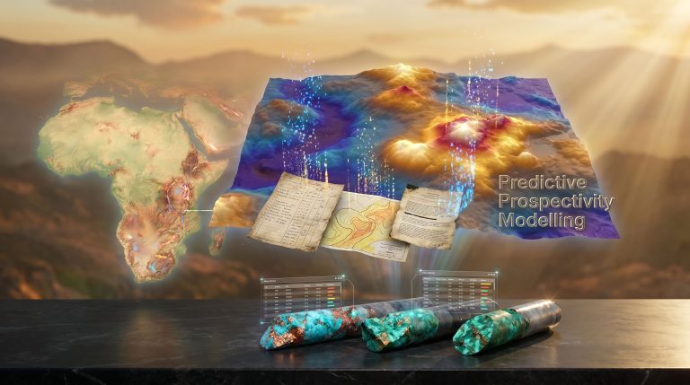
Egypt's recent partnership with Xcalibur Smart Mapping exemplifies this technological evolution. The agreement, formalised in November 2025, establishes a framework for comprehensive geophysical aerial surveys across six distinct geographic zones: the Eastern Desert, Western Desert, Sinai Peninsula, marine regions, oasis areas, and Abu Tartour. This nationwide mineral mapping initiative represents one of the most ambitious geological survey programs undertaken in the Middle East region.
When big ASX news breaks, our subscribers know first
Advanced Aerial Survey Technologies and Mineral Detection Methodologies
Aeromagnetic survey principles form the foundation of modern mineral mapping programs. These surveys measure variations in Earth's magnetic field caused by different rock types and mineral deposits beneath the surface. When deployed from aircraft platforms, magnetometers can detect subtle magnetic anomalies that indicate the presence of iron-bearing minerals, sulfide deposits, and other economically significant geological formations.
The technical specifications of contemporary survey aircraft enable comprehensive data collection across vast territories. In addition, specialised sensor arrays mounted on survey aircraft collect multiple data streams simultaneously, including magnetic field measurements, natural radioactive emissions from rocks, and electromagnetic responses from subsurface materials. This integrated approach provides a comprehensive geological fingerprint for each surveyed area.
Key technological components include:
- High-resolution magnetometers capable of detecting magnetic field variations as small as 0.1 nanotesla
- Gamma-ray spectrometers measuring natural radioactive emissions from potassium, uranium, and thorium
- Electromagnetic systems detecting conductive mineral deposits
- GPS navigation systems ensuring precise location accuracy for all measurements
- Digital data recording systems capturing real-time survey information
The data processing infrastructure supporting these surveys requires significant computational resources. Consequently, raw survey data undergoes sophisticated filtering, noise reduction, and pattern recognition analysis to identify geological anomalies worthy of ground investigation. Machine learning algorithms increasingly support this analytical process, enabling automated identification of mineral signatures across enormous datasets.
Egypt's implementation involves aircraft hangars specifically prepared for aerial survey operations, with specialised sensor systems and flight data safety protocols. However, the ministry's review of these facilities demonstrates the technical precision required for successful data-driven mining operations.
Multi-Phase Implementation Strategies for Comprehensive Coverage
Successful nationwide mineral mapping initiatives follow structured implementation phases that optimise resource allocation and maximise discovery potential. The first phase typically involves integrating historical geological records with contemporary satellite imagery on unified digital platforms. This baseline establishment enables survey teams to identify areas of highest geological interest before deploying expensive aerial survey resources.
Phase implementation typically follows this structure:
Phase 1: Digital Integration and Baseline Development
- Historical geological survey data compilation and digitisation
- Satellite imagery analysis and preliminary anomaly identification
- Geographic information system (GIS) platform establishment
- Priority zone identification based on geological potential
Phase 2: Targeted Aerial Survey Operations
- Aeromagnetic survey flights over high-priority areas
- Radiometric data collection for mineral identification
- Real-time data quality monitoring and validation
- Preliminary geological interpretation and anomaly mapping
Phase 3: Ground Verification and Detailed Assessment
- Surface geological mapping in areas showing aerial survey anomalies
- Rock sampling and geochemical analysis programs
- Drilling programs for subsurface verification (where warranted)
- Economic assessment of identified mineral resources
The Egyptian initiative demonstrates this phased approach through its planned division into six research areas. For instance, each geographic zone presents distinct geological characteristics requiring tailored survey approaches. The Eastern and Western Deserts offer different geological provinces, while marine areas require specialised survey methodologies adapted for coastal and offshore environments.
Quality control protocols ensure data accuracy throughout the implementation process. Furthermore, flight path planning, sensor calibration, and weather monitoring all contribute to survey data reliability. Safety protocols encompass both aviation safety for survey aircraft operations and data security for protecting sensitive geological information, especially when developing a mineral deposit tiers guide.
International Leadership in Mineral Mapping Innovation
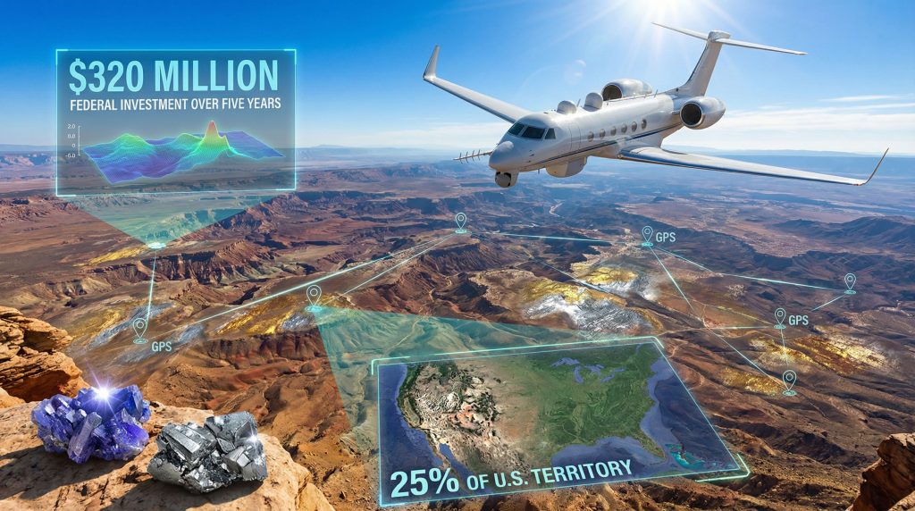
The United States Earth Mineral Resources Initiative (Earth MRI) represents the most comprehensive federal investment in mineral mapping technology. This program allocates significant federal resources toward mapping critical mineral resources across approximately 25% of U.S. territory, focusing specifically on minerals essential for clean energy infrastructure development.
According to the U.S. Geological Survey's Critical Minerals Mapping Initiative, this program aims to identify domestic mineral resources that can reduce reliance on imports. Additionally, Australia's geological survey programs, managed through Geoscience Australia, demonstrate how advanced mapping initiatives contribute to national resource security.
Key characteristics of leading international programs include:
United States Earth MRI Program:
- Comprehensive federal funding supporting multi-year implementation
- Focus on critical minerals including lithium, cobalt, and rare earth elements
- Integration with existing U.S. Geological Survey data repositories
- Emphasis on areas supporting renewable energy supply chains
Australian National Geoscience Programs:
- Continental-scale geological mapping initiatives
- Advanced hyperspectral imaging technology deployment
- Public-private partnership models for data sharing
- Integration with mining industry exploration activities
Canadian Geological Survey Modernisation:
- Natural Resources Canada leadership in technological innovation
- Emphasis on Arctic and remote region mapping capabilities
- Advanced data processing and machine learning applications
- International collaboration on geological survey standards
European Union Critical Raw Materials Mapping:
- Multi-member state coordination and resource sharing
- Focus on strategic mineral security for industrial applications
- Integration with environmental and sustainability frameworks
- Technology transfer programs for developing partner nations
Egypt's initiative positions the country alongside these internationally recognised leaders in geological survey innovation. The partnership with Xcalibur Smart Mapping provides access to established expertise and proven technological capabilities, enabling rapid deployment of advanced survey methodologies that support mining industry innovation.
Public-Private Partnership Models Driving Implementation Success
The collaboration between Egypt's Mineral Wealth and Mining Industries Authority and Xcalibur Smart Mapping demonstrates effective public-private partnership structures for large-scale geological initiatives. This partnership model enables risk-sharing between government sponsors and technical service providers while leveraging specialised expertise that government agencies might not maintain internally.
Effective partnership structures typically include:
Risk Allocation Frameworks:
- Government assumes regulatory and permitting responsibilities
- Private partners provide technical expertise and specialised equipment
- Shared financial investment in data collection and processing infrastructure
- Joint ownership or licensing of resulting geological databases
Technology Transfer Mechanisms:
- Training programs for government geological survey personnel
- Knowledge transfer from international best practices
- Local capacity building in advanced survey technologies
- Long-term maintenance and support for survey equipment
Data Governance Protocols:
- Clear intellectual property frameworks for survey results
- Public access policies for basic geological information
- Commercial confidentiality protections for detailed resource assessments
- International data sharing agreements where appropriate
Egypt's agreement enables exchange of geological and technical data, joint research programs, and cooperation on exploration activities. This comprehensive framework supports both immediate survey objectives and long-term institutional capacity development within Egyptian geological survey organisations.
Economic Benefits and Investment Attraction Strategies
Comprehensive mineral mapping initiatives generate substantial economic benefits through direct investment attraction and indirect economic development effects. The identification of previously unknown mineral resources creates immediate opportunities for exploration investment, while the improved understanding of geological potential supports long-term economic planning and industrial development strategies.
Direct economic impacts include:
Investment Attraction Metrics:
- Increased exploration licensing applications and fee revenue
- Foreign direct investment in mineral exploration activities
- Technology sector growth supporting data analysis and processing
- Job creation across technical and support service industries
Infrastructure Development Benefits:
- Road and transportation network expansion to support exploration activities
- Telecommunications infrastructure development in remote regions
- Educational institution partnerships for geological research programs
- Regional economic development in previously underexplored areas
Egypt has announced comprehensive incentive packages to maximise these economic benefits. The package includes reduced rental values for exploration contracts, tax and customs exemptions on exploration equipment and related services, unified licensing covering multiple minerals, and reconnaissance licenses designed to reduce risk for emerging companies.
The incentive structure encompasses:
- Streamlined permitting through one-stop-shop mechanisms
- Reduced administrative barriers for small and medium enterprises
- Tax advantages for exploration equipment importation
- Flexible licensing terms accommodating different company sizes and capabilities
These policies demonstrate how geological survey programs can catalyse broader economic development beyond direct mineral resource identification.
The next major ASX story will hit our subscribers first
Supporting Clean Energy Transition Through Strategic Resource Planning
Modern mineral mapping initiatives increasingly focus on identifying critical minerals essential for renewable energy infrastructure. Lithium for battery storage systems, cobalt for electric vehicle batteries, and rare earth elements for wind turbine generators represent priority targets for nations developing clean energy supply chain security.
The strategic importance of these minerals has intensified as countries pursue renewable energy transition goals and seek to reduce dependence on mineral imports from limited global suppliers. Domestic mineral identification through comprehensive geological surveys provides the foundation for developing independent clean energy supply chains.
Critical mineral priorities typically include:
Battery Technology Materials:
- Lithium deposits for energy storage applications
- Cobalt resources for electric vehicle battery production
- Nickel reserves supporting battery manufacturing
- Graphite deposits for battery electrode production
Renewable Energy Infrastructure Materials:
- Rare earth elements for wind turbine permanent magnets
- Copper resources for electrical grid expansion
- Silver deposits for solar panel manufacturing
- Aluminium resources for renewable energy system construction
Egypt's geological diversity suggests potential for multiple critical mineral types. The Eastern Desert region contains known mineral occurrences that could expand through systematic aerial survey identification. The comprehensive mapping approach enables simultaneous evaluation of multiple mineral types rather than targeting single commodities.
Implementation Challenges and Technological Solutions
Nationwide mineral mapping initiatives face significant technical, regulatory, and operational challenges that require sophisticated solutions and international cooperation. High-resolution survey equipment represents substantial capital investment, while skilled personnel requirements exceed the capabilities of many developing nations' geological survey organisations.
Technical challenges include:
Equipment and Technology Constraints:
- Limited availability of specialised aerial survey aircraft
- High operational costs for comprehensive territorial coverage
- Data processing capacity requirements exceeding local computational resources
- Quality control and calibration requirements for accurate survey results
Human Resource Limitations:
- Shortage of qualified geophysical survey operators
- Limited local expertise in advanced data interpretation techniques
- Training requirements for government geological survey personnel
- International competition for experienced technical specialists
Regulatory and Administrative Obstacles:
- Complex environmental impact assessment requirements
- Land access permissions and indigenous rights considerations
- Aviation regulatory compliance for extensive aerial survey operations
- Data security and confidentiality protocols for strategic geological information
Egypt's partnership model addresses many of these challenges through technology transfer and expertise sharing agreements. The collaboration provides access to established operational capabilities while building local institutional capacity for long-term geological survey independence, incorporating advanced techniques like 3D geological modelling.
Future Technology Integration and Global Standardisation
Emerging technologies promise to revolutionise mineral mapping capabilities through artificial intelligence, automated pattern recognition, and enhanced data integration platforms. Machine learning algorithms can identify subtle geological patterns across enormous datasets that human interpreters might overlook, while blockchain applications offer secure data sharing protocols for international geological collaboration.
Next-generation technologies include:
Artificial Intelligence Applications:
- Automated mineral signature recognition in multispectral imagery
- Predictive modelling for mineral deposit probability mapping
- Real-time data quality assessment during survey operations
- Integration of multiple data sources for comprehensive geological modelling
Advanced Survey Platforms:
- Unmanned aerial vehicle (UAV) systems for detailed local surveys
- Satellite-based hyperspectral imaging with improved resolution capabilities
- Marine geophysical surveys for offshore mineral exploration
- Ground-penetrating radar integration for near-surface mineral detection
Data Management Innovation:
- Cloud-based data processing for real-time survey analysis
- Standardised data formats enabling international collaboration
- Secure data sharing protocols protecting national resource information
- Integration with environmental monitoring for sustainable exploration planning
International standardisation efforts seek to establish common protocols for geological data collection, processing, and sharing. These standards enable countries to collaborate effectively while maintaining appropriate security for strategic geological information, particularly when implementing AI in mining tech.
The future of nationwide mineral mapping initiative programs depends on continued technological innovation, international cooperation, and sustainable development practices that balance resource discovery with environmental protection. Egypt's comprehensive approach positions the country to benefit from these advancing capabilities while contributing to global geological knowledge and clean energy transition objectives.
Disclaimer: This analysis includes speculative elements regarding future technological developments and mineral discovery potential. Economic projections and investment outcomes depend on numerous variables including global commodity markets, technological advancement rates, and regulatory environment changes. Mineral exploration involves inherent risks, and positive survey results do not guarantee economically viable mineral deposits.
Want to Stay Ahead of Major Mineral Discoveries?
Discovery Alert's proprietary Discovery IQ model delivers real-time alerts on significant ASX mineral discoveries, instantly transforming complex geological survey data into actionable investment opportunities. Begin your 30-day free trial today to uncover the next breakthrough discovery before the broader market recognises its potential.