May 14, 2026
Technical Evolution Drives Modern Ground Characterization
Canada's diverse geological landscape presents unique challenges that require sophisticated subsurface investigation methodologies. From the ancient crystalline rocks of the Canadian Shield to the complex glacial deposits covering much of the country's mining regions, effective ground characterization demands specialized technical approaches that go far beyond traditional exploration drilling.
Modern geotechnical drilling in Canada has evolved into a precision-driven discipline where data quality directly influences operational safety, regulatory compliance, and project economics. The integration of real-time monitoring systems with conventional sampling techniques creates comprehensive ground models that support critical engineering decisions throughout the mine lifecycle.
When big ASX news breaks, our subscribers know first
Core Stability Assessment Requirements Shape Mining Operations
Underground mining operations across Canada operate under increasingly stringent stability requirements that demand comprehensive subsurface characterization. Rock mass behavior prediction requires detailed understanding of structural discontinuities, groundwater conditions, and stress distribution patterns that can only be obtained through systematic drilling programs for exploration.
Provincial mining regulations now mandate professional engineer certification for all stability assessments before excavation permits are issued. This regulatory framework has transformed drilling contractors from service providers into compliance partners whose data directly supports legal documentation required for operational approval.
Critical Assessment Categories Include:
- Open pit slope stability analysis requiring kinematic evaluation of potential failure mechanisms
- Underground excavation support design based on rock mass classification systems
- Tailings facility foundation characterisation meeting dam safety regulatory requirements
- Permafrost stability evaluation for northern mining operations
- Seismic hazard assessment for deep underground workings in tectonically active regions
The Canadian Dam Association's Dam Safety Guidelines specifically require comprehensive geotechnical investigation for tailings storage facilities. Furthermore, provincial occupational health and safety regulations mandate detailed ground support design certification for underground operations.
Specialised Drilling Technologies Address Diverse Ground Conditions
Canada's geological complexity requires deployment of multiple drilling technologies optimised for specific ground conditions and investigation objectives. The selection of appropriate drilling methods directly influences sample quality and subsequent engineering analysis reliability.
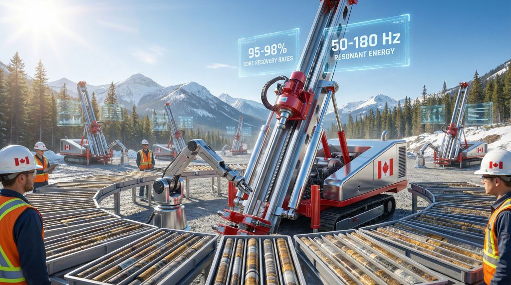
Sonic Drilling Applications
Sonic drilling technology utilises high-frequency resonant energy to advance through challenging ground conditions while maintaining sample integrity. This methodology proves particularly effective in glacial overburden characterisation where conventional drilling methods often fail to recover representative samples.
Primary Applications:
- Overburden thickness mapping above bedrock ore bodies
- Permafrost preservation during sample recovery in northern operations
- Foundation analysis for heavy mining infrastructure
- Contaminated site investigation where sample preservation is critical
The technology generates minimal frictional heat compared to rotary drilling methods. Consequently, it proves essential for permafrost investigations where thermal disturbance could compromise sample integrity and subsequent engineering analysis.
Wireline Coring Systems
Wireline drilling systems represent the standard for bedrock characterisation in Canadian mining operations. HQ-size triple-tube assemblies provide optimal core recovery in fractured rock conditions typical of many Canadian ore bodies.
System Specifications:
| Component | Specification | Application |
|---|---|---|
| Core Diameter | 63.5mm (HQ) | Standard rock mass characterisation |
| Recovery Rate | 85-95% in competent rock | Structural mapping applications |
| Drilling Fluid | Polymer-based systems | Contamination prevention |
| Orientation Capability | Magnetic/gyroscopic | Structural geology analysis |
Triple-tube configurations isolate core samples from drilling fluid circulation. This prevents contamination that could compromise laboratory testing results used for rock strength determination and ground support design.
Directional Drilling Integration
Directional drilling capabilities adapted from petroleum engineering enable targeted intersection of geological structures at optimal angles for kinematic analysis. This technology allows investigation of specific structural features that control ground stability without extensive surface access requirements.
Companies like Geotech Drilling and Malcolm Drilling have pioneered advanced directional drilling techniques that enhance subsurface characterisation capabilities.
Real-Time Data Integration Transforms Ground Characterisation
Modern geotechnical programmes emphasise continuous data acquisition throughout drilling operations rather than relying solely on recovered core samples. This approach creates comprehensive subsurface models that integrate multiple data sources for enhanced engineering analysis.
Measurement While Drilling Implementation
MWD systems record operational parameters that correlate with ground conditions, providing continuous subsurface characterisation between sampling intervals. These systems have become standard practice in Canadian mining operations where comprehensive ground understanding is essential for safety and regulatory compliance.
Monitored Parameters:
- Drilling torque indicating rock strength variations
- Penetration rate reflecting hardness changes
- Circulation pressure showing permeability conditions
- Bit rotation speed optimised for ground conditions
The continuous nature of MWD data acquisition provides ground characterisation in intervals where core recovery may be poor or impossible. This ensures comprehensive subsurface understanding throughout the investigation depth.
Downhole Geophysics Applications
Downhole geophysics systems provide 360-degree borehole imaging capabilities that map fracture orientations with surveying-grade accuracy. This technology enables quantitative structural geology analysis essential for kinematic stability evaluation.
Imaging Capabilities Include:
- Fracture orientation mapping for wedge failure analysis
- Joint spacing quantification supporting rock mass classification
- Stress-induced breakout identification indicating in-situ stress conditions
- Lithological contact definition for geological model refinement
Optical logging systems complement acoustic imaging by providing high-resolution core photography and automated fracture detection algorithms. These enhance structural mapping efficiency and consistency.
Safety Innovation Addresses Operational Hazards
Canadian mining's commitment to zero-harm objectives has driven significant technological advancement in drilling safety systems. These innovations address traditional hazards while improving operational efficiency and regulatory compliance.
Automated Handling Systems
Modern drill rigs incorporate automated rod handling systems that eliminate manual lifting requirements traditionally associated with drilling operations. These systems improve safety while reducing physical demands on drilling personnel.
Safety Features:
- Hydraulic rod manipulation eliminating manual handling
- Remote operation capability from protected operator positions
- Load monitoring systems preventing equipment overload
- Emergency shutdown protocols ensuring rapid response to hazardous conditions
The WorkSafe BC technical guidance on ergonomics and musculoskeletal injury prevention specifically identifies manual handling as a leading occupational hazard. This supports the adoption of automated systems in construction and drilling industries.
Environmental Protection Integration
Drilling operations in Canadian mining environments must comply with provincial environmental protection regulations. These mandate containment and monitoring of drilling fluids and waste materials.
Environmental Management Systems:
- Closed-loop circulation preventing drilling fluid loss
- Real-time monitoring of fluid contamination levels
- Automated containment for hazardous material management
- Documentation systems supporting regulatory compliance
Provincial environmental regulations require comprehensive drilling fluid management plans. These demonstrate prevention of groundwater contamination and soil disturbance minimisation.
Advanced Sampling Maintains Data Quality Standards
Sample integrity directly influences the reliability of laboratory testing programmes that determine rock strength parameters for ground support design. Advanced sampling techniques ensure representative samples are obtained from challenging ground conditions typical of Canadian mining environments.
Specialised Sampling Methods
The Becker Penetration Test represents a Canadian innovation developed for sampling in coarse gravelly soils. This methodology addresses situations where standard penetration testing proves unreliable.
Technical Capabilities:
- High-energy advancement through coarse granular materials
- Continuous sampling in previously challenging conditions
- Quantitative penetration resistance for bearing capacity analysis
- Undisturbed sample recovery for laboratory testing programmes
ASTM International has established standardised procedures for Becker hammer testing. This recognises its effectiveness in challenging ground conditions where conventional sampling methods fail.
Laboratory Integration Protocols
Sample preservation during transport and storage directly affects laboratory testing reliability. Standardised protocols ensure sample integrity is maintained from recovery through final testing and analysis.
Quality Control Measures:
- Temperature-controlled storage during sample transport
- Chain-of-custody documentation ensuring sample tracking
- Moisture preservation for strength testing accuracy
- Orientation marking supporting structural analysis
The Canadian Geotechnical Society provides guidelines for site material characterisation. These establish minimum standards for sample handling and laboratory testing programmes.
The next major ASX story will hit our subscribers first
Engineering Design Applications Drive Investigation Requirements
Geotechnical drilling data directly supports critical design parameters that determine operational safety and project economics. The integration of drilling results with established rock mass classification systems enables quantitative ground support design and stability analysis.
Open Pit Stability Analysis
Slope stability analysis for open pit operations requires detailed understanding of structural discontinuity orientations and rock mass strength characteristics. These are obtained through systematic drilling programmes.
Analysis Components:
- Kinematic stability evaluation using stereographic projection techniques
- Wedge failure probability calculations based on joint orientation statistics
- Factor of safety determination for various slope geometries
- Bench angle optimisation balancing safety with ore recovery
Canadian open pit operations typically require minimum factor of safety values exceeding 1.3 for operational slopes. This is achievable only through comprehensive structural characterisation obtained from oriented drilling programmes.
Underground Support Design
Underground excavation support requirements depend on rock mass quality assessment using established classification systems. These integrate drilling data with geotechnical testing results.
Classification Systems:
| System | Primary Application | Key Parameters |
|---|---|---|
| RMR (Rock Mass Rating) | General support design | Strength, RQD, spacing, condition |
| Q-System | Tunnel support | RQD, joint parameters, stress |
| GSI (Geological Strength Index) | Rock mass strength | Structure and surface condition |
These classification systems provide quantitative frameworks for support requirement determination. They are based on systematic evaluation of rock mass characteristics obtained through geotechnical drilling programmes.
Digital Technology Integration Creates Future Capabilities
The integration of digital technologies with traditional drilling methods is creating new possibilities for subsurface characterisation and real-time ground model development. Moreover, data-driven mining operations are becoming standard practice across the industry.
Digital Twin Development
Modern mining operations increasingly utilise digital twin technology that integrates continuous data streams from drilling operations with geological modelling software. This creates dynamic subsurface representations.
Integration Components:
- Real-time data incorporation from active drilling programmes
- Machine learning algorithms for pattern recognition in geological data
- Predictive modelling for ground behaviour assessment
- Risk assessment automation supporting operational decision-making
AI-powered drilling systems enhance these capabilities by providing intelligent automation and predictive analytics for drilling operations.
Remote Operation Implementation
Advanced communication systems enable real-time data transmission from remote drilling sites to central engineering offices. This supports expert consultation during drilling operations and immediate data interpretation.
Communication Capabilities:
- Satellite connectivity for remote site operations
- Expert consultation during drilling operations
- Quality control protocols implemented remotely
- Centralised project management across multiple sites
Economic Considerations Influence Programme Design
Understanding cost-benefit relationships enables optimisation of drilling programme design and resource allocation. This ensures adequate data quality for engineering analysis requirements.
Cost Structure Analysis
Drilling costs vary significantly based on methodology, site accessibility, and technical requirements. Understanding these relationships supports optimal drilling programme design for specific project objectives.
Comparative Methodology Costs:
| Methodology | Optimal Applications | Primary Cost Factors |
|---|---|---|
| Sonic Drilling | Overburden characterisation | Equipment mobilisation, specialised expertise |
| Wireline Coring | Bedrock evaluation | Depth requirements, core handling |
| Rotary Drilling | General investigation | Site accessibility, drilling conditions |
| Directional Drilling | Targeted sampling | Technical complexity, equipment requirements |
Comprehensive geotechnical programmes typically represent 2-5% of total project capital expenditure. However, they provide risk reduction benefits that can prevent cost overruns exceeding 20% through optimised design parameters and early hazard identification.
Investment Return Analysis
Adequate geotechnical investigation provides quantifiable risk reduction benefits that justify programme costs. This is achieved through improved design optimisation and hazard avoidance.
Economic Benefits Include:
- Design optimisation reducing unnecessary conservatism
- Hazard identification preventing costly remediation
- Regulatory compliance avoiding permit delays
- Insurance premium reduction through demonstrated risk management
Climate Adaptation Requirements Shape Northern Operations
Canada's changing climate conditions create new challenges for geotechnical investigation. This is particularly true in northern mining regions where permafrost stability affects infrastructure design and operational planning.
Permafrost Investigation Protocols
Northern mining operations require specialised investigation techniques that preserve permafrost integrity during sampling. These also provide thermal monitoring capabilities for long-term ground stability assessment.
Technical Requirements:
- Thermal sensor installation during drilling operations
- Ground ice content determination affecting stability calculations
- Thaw settlement modelling for infrastructure design
- Monitoring system establishment for operational management
Permafrost investigations utilise sonic drilling methods that minimise thermal disturbance during sample recovery. This ensures representative ground ice content determination essential for stability analysis.
Weather Adaptation Strategies
Extreme weather conditions across Canada require operational modifications and equipment adaptations. These ensure drilling programme continuity while maintaining safety standards.
Adaptation Measures:
- Extended operational windows in accessible northern regions
- Equipment winterisation for sub-arctic conditions
- Emergency response protocols for severe weather events
- Supply chain resilience for remote site operations
Quality Assurance Standards Ensure Data Reliability
Rigorous quality control throughout all phases of geotechnical drilling in Canada ensures data reliability and regulatory compliance. This supports defensible engineering analysis and design decisions.
Personnel Qualification Requirements
Canadian geotechnical drilling operations require qualified personnel oversight to ensure compliance with professional engineering standards and safety regulations. Following industry innovation trends, certification requirements continue to evolve.
Certification Standards:
- Professional Engineer supervision for programme design and interpretation
- Certified drilling supervisors for field operations management
- Safety training compliance meeting provincial occupational health standards
- Technical competency verification for specialised drilling methods
Provincial professional engineering associations establish minimum qualifications for geotechnical investigation design and supervision. This ensures appropriate technical oversight throughout drilling programmes.
Data Validation Protocols
Multi-stage verification procedures ensure data quality and consistency throughout geotechnical investigation programmes. These support reliable engineering analysis and regulatory compliance.
Verification Components:
- Field logging quality control during drilling operations
- Laboratory testing verification through standardised procedures
- Independent peer review of interpretation and analysis
- Regulatory compliance confirmation before permit submission
The Canadian Institute of Mining, Metallurgy and Petroleum provides guidelines for rock mass characterisation. These establish minimum standards for data collection, analysis, and reporting in mining applications.
These standards ensure consistency and reliability across geotechnical drilling programmes throughout Canada's diverse mining regions. In addition, geotechnical drilling in Canada continues to advance through technological innovation and enhanced regulatory frameworks.
"Geotechnical drilling in Canada continues evolving as mining operations adapt to increasingly complex geological environments, regulatory requirements, and technological capabilities. The integration of traditional sampling methods with advanced monitoring systems creates comprehensive ground characterisation programmes that support safe and economical mining operations across the country's diverse geological landscape."
Need Rapid Insights Into Canada's Mining Market Opportunities?
Discovery Alert's proprietary Discovery IQ model delivers immediate notifications on significant ASX mineral discoveries, transforming complex geological data into actionable investment insights for both short-term traders and long-term investors. Access comprehensive analysis of historic mineral discoveries that have generated substantial returns, and begin your 30-day free trial today to gain a competitive edge in identifying the next major breakthrough.