July 7, 2026
The Ocean That Became a Mountain Range
Few geological puzzles capture the imagination quite like the discovery of marine fossils near the upper reaches of the world's highest peaks. Ancient corals, ammonites, and the calcium-rich remains of shallow-water organisms have been recovered from Himalayan rock formations at elevations approaching 9,000 metres. These creatures never climbed. They lived, reproduced, and died at the bottom of a warm tropical sea. Their presence at extreme altitude is not a cataloguing error or a geological curiosity. It is among the most compelling pieces of physical evidence for how India collided with Asia to form the Himalayas, an event that fundamentally reconfigured the planet's climate, hydrology, and biological diversity.
Understanding this story requires stepping back not thousands but hundreds of millions of years, to a world that would be completely unrecognisable today.
When big ASX news breaks, our subscribers know first
Earth Before the Collision: A World Without the Himalayas
Roughly 250 million years ago, Earth's landmasses were consolidated into a single supercontinent known as Pangaea, surrounded by one global ocean. No Indian subcontinent existed as an independent landmass. No Himalayan peaks interrupted the horizon. No Tibetan Plateau elevated the interior of Asia. Beneath the surface, however, the planet's interior was already generating the forces that would eventually tear Pangaea apart.
Heat escaping from Earth's core drives slow convection currents within the mantle, movements that drag enormous crustal plates across the surface over geological timescales. These forces are not dramatic on a human timescale, but sustained across tens of millions of years, they are capable of dismembering supercontinents and redirecting global ocean circulation. Supercontinent cycles have played a defining role in shaping the mineral and geological character of Earth's crust.
Gondwana and India's Separation
Pangaea's fragmentation produced a southern landmass called Gondwana, which encompassed the ancestral forms of Africa, Antarctica, Australia, South America, and India. Among these fragments, India initially appeared unremarkable in scale. That changed approximately 130 million years ago when India separated from Madagascar and began an independent northward journey.
What separated India from the Eurasian landmass was the Tethys Ocean, a biologically productive marine environment that stretched between these two landmasses for tens of millions of years. Within its warm, shallow waters, vast communities of marine organisms lived and died, their calcium-rich remains accumulating on the seafloor in layers several kilometres thick. This accumulated biological material, compressed into limestone and sedimentary rock, would eventually become the raw structural material of the highest mountain range on Earth.
India's Journey: A Continental Speed Record
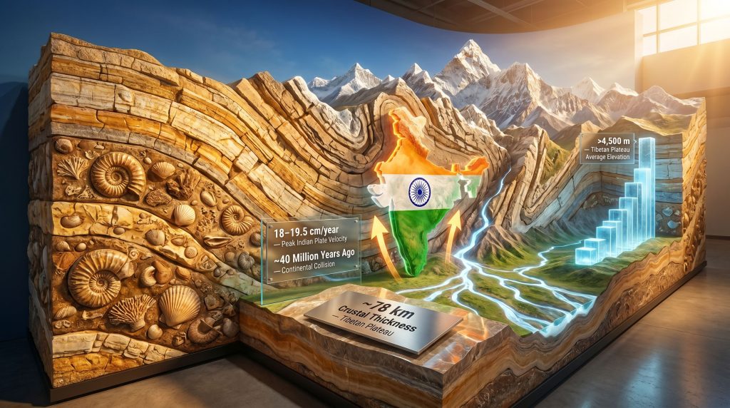
Most tectonic plates migrate at rates of roughly 2 to 5 centimetres per year. The Indian Plate achieved something geologically extraordinary, accelerating to velocities in the range of 18 to 19.5 centimetres per year at peak movement. This remains one of the fastest continental drift rates ever documented in the geological record.
| Tectonic Plate | Approximate Drift Rate | Context |
|---|---|---|
| Typical continental plate | 2–5 cm/year | Standard mantle convection |
| Indian Plate (peak velocity) | 18–19.5 cm/year | Exceptional geological anomaly |
| Indian Plate (current rate) | 4–5 cm/year | Ongoing post-collision reduced rate |
Two primary explanations have been proposed to account for this anomalous speed:
- Mantle plume propulsion: An unusually active thermal plume beneath the Indian Plate may have functioned as a geothermal engine, actively driving northward movement at accelerated rates.
- Slab pull mechanics: As the dense oceanic crust of the Tethys Ocean subducted beneath Eurasia, its gravitational descent into the mantle may have exerted a sustained pulling force on the Indian continent, drawing it forward. This mechanism currently holds broader support among geoscientists.
The exact cause of India's anomalous velocity remains an active area of geological investigation. Improved seismic imaging and computational modelling continue to refine understanding of this phenomenon, and the two mechanisms are not necessarily mutually exclusive.
The Physics of Continental Collision
Why Neither Continent Could Subduct
When oceanic crust meets a continental plate, the denser oceanic material typically sinks into the mantle through subduction. Continental crust, however, behaves differently. It is compositionally buoyant, less dense than the mantle material beneath it, and cannot be forced downward in the same way. When the Indian continental mass finally made contact with the Eurasian plate, the compressional energy of the collision had nowhere to go but upward and inward.
The analogy most useful here is not two rigid objects shattering on impact. Under conditions of extreme pressure sustained across millions of years, rock deforms plastically. It bends, folds, and flows rather than shattering. The collision zone became one of the most extraordinary examples of crustal deformation in planetary history. Furthermore, the deposit formation features associated with such deep tectonic environments are of considerable interest to economic geologists worldwide.
Orogenesis: Mountain Building in Detail
The process by which compressional forces build mountain ranges is called orogenesis. In the Himalayan case, this process involved several simultaneous mechanisms:
- Crustal folding: Rock layers buckled into giant arches and troughs under compressional stress.
- Thrust faulting: Massive slabs of crust were pushed horizontally over one another, with some rock masses travelling hundreds of kilometres from their original formation sites.
- Crustal thickening: Rather than subducting, the colliding plates stacked upon each other, dramatically increasing crustal thickness across the collision zone.
- Vertical uplift: As crustal thickness increased, the overlying rock mass was progressively elevated, carrying ancient seafloor sediments upward toward what would become the highest terrain on Earth.
The crust beneath the Tibetan Plateau thickened to approximately 78 kilometres, roughly double the thickness of typical continental crust. This deep crustal root functions analogously to the submerged portion of an iceberg, providing the structural foundation that allows peaks of Himalayan scale to remain stable.
A Two-Stage Collision: Revising the Traditional Model
For much of the twentieth century, geological consensus held that the Himalayan collision was essentially a single event occurring approximately 50 million years ago. More recent research has substantially revised this picture, introducing a two-stage model that better accounts for the physical and temporal evidence preserved in the rock record.
| Collision Stage | Event | Approximate Timing | Significance |
|---|---|---|---|
| Stage 1 | Indian Plate contacts the Kohistan-Ladakh island arc in the Tethys Ocean | ~50 million years ago | Initial deformation; island arc displaced northward |
| Stage 2 | Direct contact between India and the Eurasian continental margin | ~40 million years ago | Rapid uplift initiated; Himalayan orogeny accelerated |
Between these two stages, the remaining Tethys oceanic crust continued subducting beneath Eurasia. Volcanic arc systems developed along the collision boundary, seismic activity intensified progressively, and the Tethys Ocean was systematically consumed, its floor descending into the mantle while its accumulated sediments were compressed into the growing mountain belt.
Some models place the most intense phase of continent-to-continent compression as recently as 25 to 20 million years ago, suggesting that the dramatic Himalayan uplift familiar today is a geologically recent phenomenon relative to the collision's initiation.
Step-by-Step: How the Himalayas Rose From the Ocean Floor
- Ocean closure: Tethys oceanic crust subducted beneath Eurasia as India advanced northward across millions of years.
- Initial contact: The Indian Plate encountered the Kohistan-Ladakh island arc system within the Tethys approximately 50 million years ago.
- Continental collision: India made direct contact with the Eurasian continental margin approximately 40 million years ago.
- Crustal thickening: With subduction no longer possible, crust buckled, folded, and thickened dramatically across the collision zone.
- Thrust faulting: Giant rock slabs were displaced horizontally across vast distances, stacking crustal material.
- Vertical uplift: Compressed, thickened crust was forced upward; Tethys seafloor sediments carrying marine fossils rose toward what would become mountain summits.
- Ongoing compression: India continues its northward advance at 4 to 5 centimetres per year; uplift and seismic activity continue today.
The next major ASX story will hit our subscribers first
The Tibetan Plateau: The Collision's Larger Consequence
The Himalayan mountain range extends approximately 2,400 kilometres from the Namcha Barwa syntaxis in the east to the Nanga Parbat syntaxis in the west, containing all fourteen of Earth's peaks exceeding 8,000 metres. However, the full spatial extent of the collision's impact extends far beyond the mountain chain itself.
The Tibetan Plateau, often described as the roof of the world, averages more than 4,500 metres above sea level across an area comparable in size to Western Europe. This elevated interior represents crust that was compressed and forced upward rather than subducted during the collision. Its existence at such altitude constitutes one of the most dramatic examples of tectonic forcing of topography in Earth's history.
How the Himalayas Rewired Earth's Climate
The Asian Monsoon System
As the Himalayan range and Tibetan Plateau rose to sufficient elevation, they began intercepting large-scale atmospheric circulation patterns with permanent consequences. Warm, moisture-laden air masses moving northward from the Indian Ocean encounter the elevated Himalayan barrier, rise along the southern slopes, cool, and release their moisture as precipitation. This mechanism intensifies monsoon rainfall across South and Southeast Asia, and some regions on the Himalayan southern face receive among the highest annual rainfall totals recorded globally.
The northern aspect of the range produces the inverse effect, a vast rain shadow that blocks moisture transport and contributes substantially to the aridity of Central Asia's interior regions. For a detailed overview of how the Himalayan collision shaped the region's landscapes, the USGS resource on Himalayan geology provides authoritative background on these processes.
The Freshwater Legacy
Snow accumulation and glacial formation across the Himalayas created the largest freshwater reservoir outside the polar ice caps. The river systems fed by Himalayan glaciation sustain agricultural production and drinking water supply for populations across much of Asia.
| River System | Region Sustained | Population Scale |
|---|---|---|
| Indus | Pakistan, northwestern India | Hundreds of millions |
| Ganges | Northern India, Bangladesh | Hundreds of millions |
| Brahmaputra | Northeast India, Bangladesh | Tens of millions |
| Yangtze | Central and eastern China | Hundreds of millions |
| Mekong | Southeast Asia | Tens of millions |
| Yellow River | Northern China | Hundreds of millions |
Without the tectonic uplift generated by the India-Asia collision, the hydrological systems sustaining agricultural civilisation across much of Asia would not exist in their current form. The geological and civilisational histories of the region are inseparable.
The Rock Record: Three Categories of Geological Evidence
Himalayan geology preserves a layered archive of the collision's progression across three distinct rock categories:
- Tethyan sedimentary sequences: Marine limestone, shale, and fossil-bearing rock lifted from the ancient ocean floor. These contain ammonites, ancient corals, sea lilies, and the microscopic remains of shell-bearing organisms that once inhabited warm tropical waters. Their presence near Himalayan summits represents the most visually striking evidence of the ocean-to-mountain transformation.
- Metamorphic core rocks: Formed under extreme heat and pressure during deep crustal thickening. The metamorphic processes involved chemically transformed ordinary minerals into entirely new assemblages under conditions representative of deep collision-zone geology.
- Granitic intrusions: Generated when crustal material partially melted under the intense thermal conditions of collision, then solidified at depth and was subsequently exposed by erosion at the surface. In addition, the ore mineralogy of these intrusive bodies has significant implications for understanding associated mineral deposit systems.
An Active Collision: What GPS Measurements Reveal
Modern satellite geodesy has transformed the study of active tectonics. GPS networks can now detect crustal movements with millimetre-level precision, providing real-time confirmation that how India collided with Asia to form the Himalayas is not merely a historical account but a description of a process still unfolding today.
Current measurements confirm India continues advancing northward at approximately 4 to 5 centimetres per year. This compression drives simultaneous uplift of the Himalayan range and accumulation of elastic strain along major fault systems. When accumulated strain exceeds the frictional resistance of these faults, it is released as earthquakes, sometimes catastrophically.
The Himalayan region remains among the most seismically active zones on Earth precisely because the collision that built its mountains has never stopped. Major seismic events in this region are not geological anomalies. They are the predictable expression of active continental collision continuing beneath the surface today. The Geological Society's overview of continental collision provides further context on the mechanics driving this ongoing activity.
The Erosion-Uplift Balance
Tectonic forces continue building the range upward while erosional agents — precipitation, glacial action, river incision, wind, and mass wasting — remove material from above. The Himalayas currently exist in a dynamic equilibrium between these competing processes. Neither construction nor destruction has achieved permanent dominance, making the range both geologically young and perpetually contested. Furthermore, the surface signs of mineralisation visible across eroded Himalayan terrain provide valuable indicators for mineral exploration in such tectonically active regions.
Biodiversity and Civilisation: The Long Shadow of a Tectonic Event
The dramatic vertical relief of the Himalayas compressed an extraordinary range of ecological conditions into relatively short horizontal distances. Transitions from subtropical lowland forest through temperate woodland, alpine meadow, and permanent glacial terrain occur within distances that can be traversed on foot. This ecological compression created a mosaic of environmental niches that drove accelerated species diversification, producing biodiversity gradients comparable in magnitude to travelling from equatorial to polar latitudes.
Human civilisation developed in direct relationship with the geography produced by the collision. Agricultural calendars across South and East Asia were shaped by the monsoon system the mountains created. Trade routes, political boundaries, and cultural exchange patterns developed around river systems fed by Himalayan glaciation. The mountains themselves served as natural barriers that channelled and constrained the interaction of civilisations across millennia.
Frequently Asked Questions
How long did it take for the Himalayas to form?
The Himalayan orogeny has been an ongoing process spanning approximately 40 to 50 million years. Initial contact between the Indian Plate and island arc systems occurred around 50 million years ago, with direct continent-to-continent collision beginning approximately 40 million years ago. Mountain building continues today.
Why didn't one continent sink beneath the other?
Continental crust is compositionally buoyant and cannot be subducted the way denser oceanic crust can. When two continental plates collide, compressional energy is expressed as crustal thickening, folding, and vertical uplift rather than one plate descending into the mantle.
How thick is Earth's crust beneath Tibet?
Approximately 78 kilometres, roughly double the thickness of typical continental crust, a direct consequence of the compressional forces generated by the India-Asia collision.
What happened to the Tethys Ocean?
The Tethys was systematically eliminated as India advanced northward. Its oceanic crust subducted into the mantle while accumulated seafloor sediments were incorporated into the growing mountain range. Marine fossils found near Himalayan summits are the biological legacy of this vanished ocean.
Will the Himalayas eventually stop growing?
As long as India continues its northward advance, compressional forces will persist. Over geological timescales spanning hundreds of millions of years, the collision will eventually diminish and erosion will progressively reduce the range. For now, growth and erosion continue in approximate equilibrium.
Summary: Key Data Points
| Parameter | Value | Significance |
|---|---|---|
| Age of initial collision | ~50 million years ago | First contact with island arc system |
| Age of continental collision | ~40 million years ago | Direct India-Eurasia contact |
| Peak Indian Plate velocity | 18–19.5 cm/year | Among fastest continental drift rates recorded |
| Current Indian Plate velocity | 4–5 cm/year | Ongoing active collision |
| Himalayan range length | ~2,400 km | World's highest mountain system |
| Tibetan Plateau average elevation | >4,500 metres | Largest high-altitude plateau on Earth |
| Crustal thickness beneath Tibet | ~78 km | Approximately double normal continental crust |
Every ridge in the Himalayan range records compression. Every folded rock layer preserves ancient tectonic struggle. Every marine fossil embedded in summit rock tells the story of how India collided with Asia to form the Himalayas and, in doing so, erased an entire ocean from the planet's surface. And every earthquake that shakes the region serves as a reminder that the collision responsible for all of this has not ended. It is still happening, centimetre by centimetre, beneath one of the most extraordinary landscapes on Earth.
Want to Stay Ahead of the Next Major Mineral Discovery?
The same tectonic forces that built the Himalayas continue to concentrate valuable mineral deposits across some of the world's most geologically active regions — and Discovery Alert's proprietary Discovery IQ model delivers real-time alerts the moment significant ASX mineral discoveries are announced, turning complex geological data into actionable investment insights. Explore historic discoveries and their returns to understand the potential of being early, then begin your 14-day free trial at Discovery Alert to position yourself ahead of the broader market.