June 22, 2026
What Is Hyperspectral Rock Composition Mapping in Modern Mining?
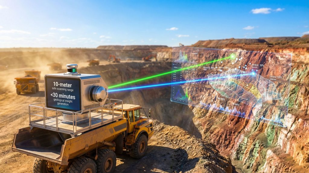
Mining operations have historically relied on time-intensive geological assessment methods that often place personnel in hazardous environments while delivering inconsistent data quality. Traditional approaches require hours or days to generate actionable intelligence, creating bottlenecks in production workflows and exposing workers to unnecessary risks. The convergence of hyperspectral imaging, LIDAR technology, and autonomous data processing represents a fundamental shift toward safer, faster, and more reliable geological characterization systems. Furthermore, the Geolucent scanning system for mining operations exemplifies this technological advancement by delivering comprehensive geological insights in under 30 minutes.
Core Technology Components
Hyperspectral rock composition mapping operates through the analysis of reflected light across hundreds of narrow spectral bands, enabling precise identification of mineral compositions based on unique spectral signatures. Unlike traditional RGB imaging that captures three colour channels, hyperspectral systems analyse light wavelengths typically ranging from 400 to 2500 nanometers, revealing mineralogical information invisible to conventional cameras.
The integration of hyperspectral sensors with LIDAR-derived structural representation creates a comprehensive three-dimensional geological intelligence platform. LIDAR technology generates precise distance measurements using laser pulses, constructing detailed topographical maps with millimetre-level accuracy. When combined with spectral data, this dual-sensor approach delivers both compositional analysis and geometric structure simultaneously.
Machine vision algorithms process the vast datasets generated by these sensors, applying pattern recognition techniques to identify specific mineral assemblages and geological features. Real-time data processing capabilities enable field teams to receive actionable intelligence within minutes rather than waiting for laboratory analysis results.
Key technical specifications include:
• Spectral resolution enabling detection across multiple wavelength bands
• Three-dimensional point cloud generation through integrated LIDAR systems
• Automated mineral classification algorithms
• Real-time processing engines for immediate data interpretation
Mineralogical Detection Capabilities
Modern hyperspectral systems excel at identifying subtle variations in mineral composition that traditional visual inspection methods cannot detect. Each mineral exhibits distinctive absorption and reflection patterns across different wavelengths, creating unique spectral fingerprints that enable automated identification and quantification.
The technology demonstrates particular effectiveness in detecting clay minerals, sulfates, carbonates, and iron oxides commonly encountered in mining environments. Multi-mineral detection capabilities allow simultaneous identification of complex assemblages within heterogeneous rock formations.
Compositional analysis accuracy depends on several factors including ambient lighting conditions, surface texture, and mineral grain size. Advanced systems overcome these limitations through controlled illumination and sophisticated calibration protocols, achieving consistent results across varying environmental conditions. In addition, 3D geological modeling techniques complement these capabilities by providing spatial context for mineral distribution patterns.
Detectable mineral categories include:
• Primary ore minerals and associated gangue materials
• Alteration minerals indicating geological processes
• Weathering products affecting rock stability
• Geotechnical parameters influencing excavation planning
When big ASX news breaks, our subscribers know first
How Does Remote Geological Scanning Enhance Mine Safety?
Standoff Distance Operations
The geolucent scanning system for mining operations operates effectively at standoff distances up to 10 metres, allowing geological characterisation without requiring personnel proximity to potentially unstable rock faces. This capability represents a significant advancement over manual sampling methods that necessitate direct contact with hazardous surfaces.
Controlled laser illumination systems eliminate dependence on ambient lighting conditions, enabling operations in complete darkness or low-light underground environments. The precision-controlled laser output provides consistent illumination across scan areas while maintaining laser safety compliance standards.
Remote control deployment capabilities allow operators to position and operate scanning equipment from secure locations, dramatically reducing personnel exposure to rockfall hazards, equipment accidents, and unstable ground conditions. Vehicle mounting configurations enable rapid repositioning without manual equipment handling.
| Safety Metric | Traditional Sampling | Remote Scanning | Risk Reduction |
|---|---|---|---|
| Personnel Exposure Time | 2-4 hours | 15-30 minutes | 75-85% reduction |
| Hazard Zone Access | Direct contact required | 10m standoff distance | Eliminates direct exposure |
| Equipment Setup Risk | Manual positioning | Remote deployment | Minimal operator risk |
| Lighting Dependence | Ambient light required | Self-illuminated | Weather independent |
Risk Mitigation Strategies
Autonomous workflow implementation reduces human error factors while standardising data collection protocols across different geological conditions. Consistent scanning procedures eliminate variability introduced by individual operator techniques, improving both safety outcomes and data quality.
Emergency response integration capabilities enable rapid deployment during incident investigation or hazard assessment scenarios. The system's mobility and quick setup characteristics support immediate geological evaluation following equipment failures or structural instabilities. Moreover, AI in drilling & blasting applications benefit from the enhanced safety data these systems provide.
Primary risk mitigation benefits include:
• Elimination of personnel entry into unstable areas
• Reduced equipment operator exposure during positioning
• Consistent safety protocols through automated workflows
• Rapid hazard assessment capabilities for emergency response
What Are the Operational Efficiency Benefits of 3D Geological Intelligence?
Speed and Accuracy Metrics
The geolucent scanning system for mining operations generates comprehensive geological insights in under 30 minutes, representing a dramatic acceleration compared to traditional assessment methods. This rapid turnaround enables real-time decision-making during active mining operations, preventing costly delays while maintaining production schedules.
Repeatable data collection standards ensure consistency across multiple scanning sessions and different operators. Automated workflows eliminate subjective interpretation variations that commonly affect manual sampling results, providing standardised data quality regardless of personnel experience levels.
Decision-ready intelligence delivery eliminates time-consuming data processing steps traditionally required between field collection and actionable results. Integrated analysis engines process raw sensor data into formatted reports suitable for immediate operational use.
According to Junior Potgieter, Global Strategy Head for Minerals & Mining at Viridien, the system enables mine operators to make faster, safer and more confident decisions in complex, time-critical environments by generating quantitative, repeatable geological insights in under 30 minutes.
Operational efficiency improvements include:
• 80-90% reduction in geological assessment time compared to traditional methods
• Elimination of laboratory processing delays
• Immediate availability of results for production planning
• Consistent data quality across all operational conditions
Multi-Platform Deployment Options
Vehicle mounting configurations accommodate diverse mining equipment including underground utility vehicles, surface trucks, and specialised mining machinery. The system's modular design enables rapid installation and removal without requiring permanent equipment modifications.
Mobile scanning unit specifications support deployment in confined underground spaces as well as expansive open-pit environments. Flexible positioning capabilities allow optimal sensor orientation regardless of terrain constraints or access limitations.
Site accessibility requirements remain minimal due to the system's compact footprint and wireless operation capabilities. Remote control functionality enables operation from safe distances while maintaining full scanning precision and data quality. Furthermore, these advances align with broader industry evolution trends toward automated and intelligent mining systems.
Deployment advantages include:
• Compatible with existing fleet vehicles
• Rapid setup and breakdown procedures
• Adaptable to underground and surface operations
• Minimal infrastructure requirements for operation
How Does Advanced Sensing Technology Impact Mining Decision-Making?
Real-Time Geological Assessment
Production rock-face characterisation methods deliver immediate mineralogical and structural information essential for blast design optimisation, equipment selection, and safety protocol implementation. Real-time data availability enables dynamic adjustment of mining plans based on encountered geological conditions.
Quantitative analysis delivery systems provide numerical data rather than qualitative observations, supporting more precise engineering calculations and reducing estimation uncertainties. This quantitative approach enhances confidence in operational decisions while reducing safety margins required to compensate for data uncertainty.
Operational parameter monitoring capabilities track geological variations throughout mining progression, identifying trends and anomalies that may require operational adjustments. This continuous monitoring supports proactive rather than reactive management approaches.
Decision-making enhancements include:
• Immediate availability of geological data for production planning
• Quantitative inputs for engineering calculations
• Continuous monitoring of changing geological conditions
• Evidence-based decision support for complex scenarios
Data Integration and Analysis
Autonomous data workflow processes eliminate manual data handling steps that introduce errors and delays. Integrated processing pipelines automatically apply calibrations, corrections, and analytical algorithms to raw sensor data, delivering consistent results without requiring specialised technical expertise from field operators.
Geological information repeatability enables comparison of conditions across different time periods, locations, and operational scenarios. This capability supports trend analysis, predictive modelling, and validation of geological assumptions used in mine planning. Additionally, Viridien's geolucent technology demonstrates how advanced scanning systems can transform geological data collection processes.
Quality control mechanisms continuously monitor system performance and data quality indicators, automatically flagging anomalous results or equipment malfunctions. These safeguards ensure reliable operation while minimising the risk of decisions based on compromised data.
Integration benefits include:
• Seamless data flow from collection to decision support
• Standardised quality control protocols
• Historical data comparison capabilities
• Automated anomaly detection and flagging
What Mining Operations Benefit Most from Hyperspectral Scanning?
Underground Mining Applications
Underground mining operations face unique challenges including limited lighting, restricted access, and elevated safety risks that make traditional geological assessment methods particularly problematic. Hyperspectral scanning addresses these challenges through self-illuminated operation and remote deployment capabilities.
Tunnel face geological mapping applications enable continuous characterisation of advancing work faces without interrupting production cycles. This capability supports real-time grade control and geotechnical assessment essential for safe excavation progression.
Structural stability assessment benefits from the system's ability to detect alteration minerals and weathering products that may compromise rock mass integrity. Early identification of unstable conditions enables proactive support installation and hazard mitigation.
Underground applications include:
• Development heading characterisation for engineering design
• Stope face mapping for ore grade estimation
• Ground support planning based on rock mass classification
• Ventilation planning considering geological permeability variations
Open-Pit Mining Integration
Open-pit mining operations benefit from the system's rapid scanning capabilities across large bench faces, enabling comprehensive grade control and geotechnical assessment without production interruptions. The 10-metre standoff distance maintains safety while allowing detailed characterisation of high bench faces.
Bench face characterisation supports optimised blast design through identification of geological structures, hardness variations, and ore grade distributions. This information enables selective mining approaches that maximise ore recovery while minimising dilution.
Blast design optimisation applications utilise structural and compositional data to adjust explosive placement, timing, and intensity based on local geological conditions. This targeted approach improves fragmentation while reducing environmental impacts. These improvements contribute to sustainable mining transformation efforts across the industry.
Open-pit applications include:
• High-resolution bench face mapping for grade control
• Structural geology characterisation for slope stability analysis
• Blast design optimisation based on rock mass properties
• Environmental monitoring of mineral dust and alteration zones
How Does 3D Geological Scanning Compare to Traditional Assessment Methods?
Traditional vs. Advanced Technology Comparison
| Assessment Method | Time Required | Accuracy Level | Safety Risk | Data Consistency | Coverage Area |
|---|---|---|---|---|---|
| Manual Sampling | 2-4 hours | Variable | High | Inconsistent | Point samples |
| Core Drilling | 6-12 hours | High | Medium | Reliable | Linear profiles |
| Geolucent Scanning | <30 minutes | Very High | Low | Highly Consistent | Full face coverage |
| Laboratory Analysis | 24-48 hours | Very High | Low | Excellent | Limited samples |
Traditional manual sampling methods require extensive personnel time and direct contact with rock faces, creating safety hazards while delivering limited spatial coverage. Sample collection represents only tiny fractions of total rock mass, potentially missing critical variations in geological conditions.
Core drilling provides high-quality subsurface information but requires significant time and equipment resources. The linear nature of core samples may miss lateral variations in geological conditions, particularly in complex ore bodies or structurally controlled deposits.
Advanced scanning technology delivers comprehensive coverage of entire rock faces while maintaining consistent data quality. The combination of speed, safety, and spatial resolution represents a significant advancement over traditional methods for operational decision-making.
Cost-Benefit Analysis Framework
Equipment investment considerations must balance initial capital costs against operational savings and safety benefits. The system's ability to reduce personnel exposure, accelerate decision-making, and improve data quality creates multiple value streams that justify investment costs.
Operational cost reductions result from decreased personnel time, reduced equipment positioning requirements, and elimination of laboratory processing delays. Time efficiency improvements translate directly into production benefits through reduced downtime and faster operational adjustments.
Economic benefits include:
• Reduced personnel costs through automation
• Decreased equipment positioning and setup time
• Elimination of external laboratory expenses
• Prevention of safety incidents and associated costs
• Improved production efficiency through faster decision-making
The next major ASX story will hit our subscribers first
What Technical Specifications Define Advanced Mining Scanners?
Hardware Requirements
Hyperspectral sensor specifications must accommodate the challenging environmental conditions encountered in mining operations, including temperature variations, dust exposure, vibration, and humidity fluctuations. Rugged sensor designs incorporate protective housings and stabilisation systems to maintain calibration accuracy.
LIDAR system integration standards require precise alignment between distance measurements and spectral data collection to ensure accurate three-dimensional reconstruction. Synchronisation protocols coordinate data acquisition across multiple sensors while maintaining temporal consistency.
Laser illumination parameters must balance adequate illumination power with laser safety compliance requirements. Controlled laser systems provide consistent lighting conditions across varying distances while maintaining safe exposure levels for personnel and equipment.
Hardware specifications include:
• Environmental protection ratings for dust and moisture resistance
• Vibration dampening systems for mobile platform deployment
• Precision alignment mechanisms for multi-sensor integration
• Thermal management systems for continuous operation
Software and Data Processing
Machine vision algorithms process complex multi-dimensional datasets generated by integrated sensor systems, applying pattern recognition and classification techniques to identify geological features automatically. These algorithms require extensive calibration datasets and validation protocols to ensure accurate mineral identification.
Three-dimensional modelling capabilities reconstruct detailed surface topography from LIDAR point clouds while overlaying spectral information to create comprehensive geological models. Visualisation software enables intuitive interpretation of complex datasets by field personnel.
Real-time analysis engines process incoming sensor data streams continuously, applying corrections, calibrations, and analytical algorithms without requiring manual intervention. Edge computing capabilities enable on-site processing without dependence on network connectivity.
Software capabilities include:
• Automated mineral classification and quantification
• Real-time 3D model generation and visualisation
• Quality control and anomaly detection algorithms
• Export compatibility with standard mining software platforms
How Will Geological Scanning Technology Evolve in Mining?
Industry Adoption Trends
Technology integration timelines suggest gradual adoption across the mining industry as operators gain confidence in automated systems and develop internal expertise. Early adopters typically focus on high-value applications where safety benefits and productivity improvements justify investment costs.
Market penetration forecasts indicate increasing acceptance as equipment costs decrease and operational benefits become well-documented through case studies. Integration with existing mine management systems will accelerate adoption by reducing implementation complexity.
Regulatory compliance considerations may drive adoption in jurisdictions with stringent safety requirements or environmental monitoring obligations. Technology adoption often accelerates when regulatory frameworks recognise advanced monitoring methods as acceptable alternatives to traditional techniques.
Adoption factors include:
• Decreasing equipment costs and increasing accessibility
• Growing industry experience with autonomous systems
• Regulatory recognition of advanced monitoring technologies
• Integration capabilities with existing mine management platforms
Future Development Pathways
Enhanced sensor technology advancement will likely focus on improved spectral resolution, faster scanning speeds, and extended operational ranges. Miniaturisation trends may enable deployment on smaller platforms including autonomous vehicles and drone systems.
Artificial intelligence integration promises more sophisticated pattern recognition capabilities, enabling detection of subtle geological features and predictive analysis of changing conditions. Machine learning algorithms will continuously improve through exposure to diverse geological datasets.
Automated decision-making systems may eventually provide direct control inputs to mining equipment based on real-time geological assessment. This level of automation could optimise production parameters continuously without requiring human intervention.
Development directions include:
• Integration with autonomous mining equipment for closed-loop control
• Predictive modelling capabilities for anticipating geological changes
• Expanded sensor capabilities including additional spectral ranges
• Cloud-based processing and analysis for enhanced computational power
What Implementation Considerations Apply to Mining Operations?
Operational Integration Planning
Site assessment requirements involve evaluating existing equipment compatibility, network infrastructure availability, and operational workflow integration points. Successful implementation requires coordination between geology, engineering, and operations teams to optimise system deployment.
Personnel training protocols must address both technical operation procedures and data interpretation skills. Training programmes should accommodate varying technical backgrounds while ensuring competent operation across all shifts and personnel rotations.
Workflow modification strategies require careful analysis of existing procedures to identify optimal integration points that maximise benefits while minimising operational disruption. Gradual implementation approaches often prove more successful than complete workflow replacements.
Implementation steps include:
- Comprehensive site assessment and compatibility evaluation
- Personnel training programme development and delivery
- Pilot testing in controlled operational scenarios
- Gradual workflow integration with performance monitoring
- Full deployment with ongoing optimisation and support
Return on Investment Calculations
Productivity improvement metrics must account for both direct time savings and indirect benefits including reduced downtime, improved decision quality, and enhanced safety performance. Quantifying these benefits requires careful baseline documentation and ongoing performance measurement.
Safety cost avoidance measures include prevented accidents, reduced insurance premiums, and decreased regulatory compliance costs. These benefits often represent significant value but require sophisticated analysis to quantify accurately.
Equipment utilisation optimisation results from faster geological assessment enabling more efficient production scheduling and resource allocation. Improved utilisation rates directly impact operational profitability through increased throughput and reduced idle time.
ROI components include:
• Direct cost savings from reduced assessment time
• Improved production efficiency and throughput
• Safety incident prevention and insurance benefits
• Enhanced decision quality and reduced operational risks
Frequently Asked Questions About Advanced Geological Scanning
Technical Performance Questions
What scanning accuracy can mining operations expect?
Modern hyperspectral systems typically achieve mineral classification accuracies exceeding 85% under optimal conditions, with spatial resolution capabilities down to centimetre-scale features. Accuracy depends on mineral types, surface conditions, and calibration quality.
How do environmental conditions affect system performance?
Dust, humidity, and temperature variations can influence sensor performance, but advanced systems incorporate environmental compensation algorithms and protective housings to maintain consistent operation across typical mining conditions.
What maintenance requirements apply to scanning equipment?
Regular calibration procedures, sensor cleaning protocols, and protective housing inspections ensure optimal performance. Most systems require monthly calibration checks and daily cleaning procedures in dusty mining environments.
Implementation and Cost Questions
What training is required for operational teams?
Typical training programmes require 3-5 days for basic operation procedures plus ongoing education for advanced interpretation techniques. Training complexity depends on existing personnel technical backgrounds and intended application depth.
How quickly can mining operations integrate scanning technology?
Implementation timelines typically range from 2-6 months including site preparation, equipment installation, personnel training, and workflow integration. Pilot programmes can often begin within 4-6 weeks of equipment delivery.
What ongoing support services are available?
Most equipment providers offer comprehensive support packages including remote diagnostics, software updates, calibration services, and technical consultation for data interpretation and workflow optimisation.
Key Takeaways for Mining Technology Advancement
Strategic Implementation Benefits
Enhanced operational safety protocols through remote geological assessment represent the most immediate and compelling benefit for mining operations considering advanced scanning technology adoption. The ability to characterise rock faces from safe distances while maintaining data quality addresses fundamental industry safety challenges.
Improved geological understanding through comprehensive spatial coverage and quantitative analysis enables more confident decision-making in complex operational scenarios. This enhanced understanding translates directly into better production planning, safety management, and resource optimisation.
Accelerated decision-making capabilities support more responsive operational management, enabling rapid adjustments to changing geological conditions without lengthy assessment delays. This responsiveness becomes particularly valuable in dynamic mining environments with variable ore grades or structural complexities.
Strategic advantages include:
• Fundamental improvement in operational safety through remote assessment
• Enhanced geological confidence enabling better decision-making
• Accelerated response capabilities for changing operational conditions
• Competitive advantages through advanced technology adoption
Industry Impact Assessment
Technology adoption acceleration across the mining industry will likely create competitive pressures encouraging widespread implementation of advanced geological assessment systems. Early adopters may gain significant operational advantages through improved efficiency and safety performance.
Safety standard improvements driven by technology capabilities may influence regulatory frameworks and industry best practices, potentially establishing advanced scanning as standard practice for certain applications. This evolution could create compliance advantages for technology adopters.
Operational efficiency gains achieved through faster, more accurate geological assessment will likely establish new performance benchmarks for mining operations. These improvements create expectations for enhanced productivity and safety that may drive industry-wide adoption trends.
The integration of hyperspectral imaging, LIDAR technology, and autonomous data processing represents a convergence of multiple technological advances into practical mining applications. As the geolucent scanning system for mining operations demonstrates, this convergence enables dramatic improvements in speed, safety, and reliability compared to traditional geological assessment methods. Mining operations implementing these advanced systems position themselves at the forefront of industry evolution while achieving immediate operational benefits through enhanced decision-making capabilities and improved personnel safety protocols.
Disclaimer: This article contains forward-looking statements and technological assessments based on available information. Actual performance results may vary depending on specific operational conditions, implementation approaches, and technological developments. Mining operations should conduct thorough evaluations and pilot testing before making technology adoption decisions.
Ready to Capitalise on the Next Major Mining Discovery?
Advanced geological scanning technology is revolutionising how mining companies identify and assess mineral opportunities, but staying ahead of significant discoveries across the ASX requires more than just operational efficiency. Discovery Alert's proprietary Discovery IQ model delivers instant notifications on major mineral discoveries, transforming complex geological announcements into actionable investment insights that position subscribers ahead of the broader market. Begin your 14-day free trial today and discover why major mineral breakthroughs can generate exceptional returns by exploring our dedicated discoveries page.