
June 29, 2026
Understanding the Core Mechanics of In-Situ Recovery Technology
The uranium extraction landscape has evolved dramatically over the past five decades, with in-situ recovery (ISR) emerging as the dominant methodology for uranium production worldwide. This groundwater-based extraction technique operates by circulating oxygenated solutions through underground ore bodies, dissolving uranium minerals without disturbing surface terrain or requiring extensive excavation operations.
ISR technology functions through a network of injection and recovery wells strategically positioned throughout mineralized zones. The process begins with injecting a leach solution containing dissolved oxygen and sodium bicarbonate into the host sandstone formation. This solution mobilizes uranium minerals from their solid state, creating a uranium-bearing pregnant solution that extraction wells then pump to surface processing facilities.
The operational advantages of ISR extend beyond simple cost considerations. Traditional open-pit uranium mining operations require removing millions of tons of overburden, creating substantial surface disturbance and generating significant waste rock volumes. ISR operations, by contrast, maintain minimal surface footprints while accessing uranium deposits through targeted well networks.
Wyoming's regulatory framework provides additional advantages for ISR development through its Agreement State status with the Nuclear Regulatory Commission. Furthermore, this designation allows state-level licensing oversight for uranium recovery operations, streamlining mining permitting overview processes and enabling more responsive regulatory interaction compared to direct federal oversight.
The technical requirements for successful ISR operations centre on specific geological conditions that facilitate solution flow and uranium recovery. Host formations must demonstrate sufficient permeability for solution circulation, adequate confinement to prevent solution migration beyond target zones, and favourable geochemical conditions that enable uranium dissolution and recovery.
When big ASX news breaks, our subscribers know first
Geological Foundations of Roll-Front Uranium Systems
Roll-front uranium deposits represent one of nature's most systematic mineralisation processes, occurring where groundwater chemistry transitions create precipitation zones within permeable sandstone formations. These deposits form along redox boundaries where oxidised, uranium-bearing groundwater encounters reducing conditions, causing uranium minerals to precipitate in characteristic crescent-shaped patterns.
The formation process begins with uranium-bearing surface waters infiltrating permeable sandstone formations. As these oxidised solutions migrate through the formation, they encounter organic matter, sulfides, or other reducing agents that alter the groundwater chemistry. This chemical transition zone becomes the locus for uranium precipitation, creating mineralised zones that can extend for miles along favourable geological horizons.
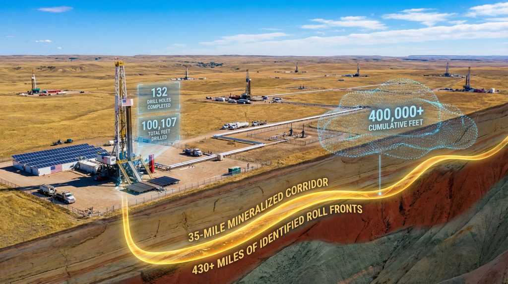
At the Kaycee ISR Uranium Project, recent drilling has revealed the complexity of roll-front systems within the Powder River Basin's sedimentary sequence. The project's 2025 drilling campaign, comprising 132 drill holes totalling over 100,000 feet, has identified mineralisation patterns that extend beyond traditional roll-front models.
Formation-Specific Characteristics:
• Wasatch Formation: Primary ISR target demonstrating proven lateral continuity across multiple sand packages
• Fort Union Formation: Secondary target zone showing expanding potential through recent exploration results
• Lance Formation: Deeper exploration opportunity requiring additional evaluation for ISR viability
The geological architecture at Kaycee demonstrates mineralisation concentrated near sand-organic interfaces, where permeability contrasts and localised reducing agents control uranium precipitation. This differs from textbook roll-front models that emphasise strong iron-oxide alteration signatures.
Several mineralised intervals at Kaycee exhibit pale, carbonate-cemented sands adjacent to thin organic horizons, where elevated radiation signatures persist despite muted visual alteration characteristics. This observation highlights the influence of carbonate buffering and organic-controlled reduction in shaping redox front expression within specific Powder River Basin settings.
Comparative Analysis: Regional ISR Development Context
| Project | Distance from Kaycee | Operator | Formation Target | Current Status |
|---|---|---|---|---|
| Nichols Ranch | <5 miles east | Energy Fuels | Wasatch/Fort Union | Operating |
| Christensen Ranch | Regional proximity | Uranium Energy Corp | Similar formations | Operating |
| Smith Ranch-Highland | Regional proximity | Cameco | Multiple formations | Operating |
This regional context demonstrates the Powder River Basin's established track record for ISR uranium production. The proximity of operating facilities provides infrastructure advantages and validates the geological model supporting ISR development across the district.
Strategic Land Consolidation and Resource Potential
Premier American Uranium has assembled a comprehensive land position spanning 55 square miles of consolidated mineral rights, establishing control over a 35-mile mineralised corridor. This represents the first unified district control since consolidation efforts in the early 1980s, providing strategic advantages for systematic ISR development.
The consolidated acreage encompasses over 430 miles of identified roll fronts across the property, based on integration of 3,800+ historical drill holes and recent exploration results. However, following the deposit classification guide, this historical database provides over 1,000 vertical feet of confirmed mineralisation across multiple formations.
Strategic Advantages of Unified Control:
• Integrated hydrogeological assessment without ownership fragmentation barriers
• Coordinated wellfield development across multiple mineralised sand packages
• Unified groundwater flow management for optimised ISR operations
• Strategic flexibility enabling phased development approaches
The multi-formation resource potential spans three distinct geological units, each offering different development characteristics and timeline considerations. The Wasatch Formation serves as the primary ISR target, with demonstrated continuity and favourable hydrogeological properties. Fort Union Formation targets represent secondary development opportunities with expanding potential based on recent drilling results.
Lance Formation occurrences provide deeper exploration opportunities that may extend the project's resource base, though additional evaluation remains necessary to establish ISR viability at those depths.
Technical Innovations in Modern ISR Exploration
The 2025 drilling campaign at Kaycee represents what industry sources describe as the largest grassroots ISR exploration program currently active in the United States. The 132-hole program covering 100,107 total feet targeted specific ISR-relevant parameters rather than pursuing traditional high-grade intercept objectives.
Advanced Geological Interpretation Methodologies:
The exploration approach emphasised systematic pattern recognition, integrating channel-scale sand geometry with stratigraphic relationships and organic matter distribution within fluvial sand sequences. Consequently, this methodology enabled iterative geological interpretation that refined targeting criteria based on evolving subsurface understanding.
The drilling exploration programs evaluated four critical ISR development parameters:
• Sand continuity and channel architecture mapping across target zones
• Permeability contrast identification at sand-organic interfaces
• Groundwater flow pattern integration with mineralisation geometry
• Lateral predictability assessment for systematic wellfield development
Target Zone Performance Analysis:
The Outpost Discovery Zone achieved mineralisation intersection in 11 of 23 drill holes, with 8 holes exceeding the 0.02% eU₃O₈ over 2-foot minimum thickness criterion relevant for ISR evaluation. This 47.8% intersection rate demonstrated coherent roll-front system behaviour rather than isolated anomaly occurrence.
Rustler Corridor expansion drilling intersected mineralisation in 22 of 81 holes, with 15 holes meeting ISR-relevant grade-thickness criteria. For instance, the results established a 3.5-mile north-south trending redox corridor with systematic architecture suitable for future wellfield development.
The convergence of proven geological continuity with established ISR operational precedent in the Powder River Basin creates development optionality where technical execution becomes the primary value driver rather than exploratory uncertainty management.
Stampede connectivity validation demonstrated inter-zone continuity between adjacent mineralised trends, confirming interpretation of connected redox systems operating across stacked sand sequences. This systematic architecture provides the foundation for coordinated ISR development across multiple geological horizons.
Market Positioning and Economic Catalysts
The uranium market environment has transformed significantly since the early 2020s, with supply chain security considerations and growing nuclear energy demand creating favourable conditions for domestic ISR development. Furthermore, the u.s. uranium import ban has strengthened long-term uranium price projections that support the economic viability of ISR operations.
Additionally, uranium market volatility creates opportunities for projects with established geological frameworks and strategic infrastructure positioning. The regional workforce possesses extensive ISR operational experience, whilst established contractor networks and service providers support efficient project execution.
Infrastructure and Operational Advantages:
The Powder River Basin's established ISR ecosystem provides significant development advantages through existing processing facilities within economic transport distances. Existing power transmission and water supply infrastructure reduces capital requirements for new ISR operations, while Wyoming's pro-energy regulatory environment facilitates project permitting and development approval processes.
Resource Definition Pathway:
The progression toward resource estimation and development planning builds upon the 100,000+ feet of recent drilling data integrated with historical exploration results. This database supports preparation of NI 43-101 compliant resource estimates that will define the project's economic parameters and development timeline.
Metallurgical testing programmes will optimise leach solution chemistry for the specific mineralogical characteristics identified through the drilling campaign. Hydrological studies will establish wellfield design parameters based on the documented geological architecture and groundwater flow characteristics.
Development Timeline and Investment Implications
The technical progress achieved through systematic exploration positions the Kaycee ISR Uranium Project for accelerated development compared to grassroots exploration programmes. The combination of proven geological continuity, established ISR technology precedent, and favourable regulatory environment creates multiple value inflection points over the near-term development timeline.
Key Development Milestones:
• Resource estimate publication integrating 400,000+ cumulative feet of drilling data
• Preliminary economic assessment development incorporating current uranium market parameters
• Environmental baseline studies leveraging regional ISR operational data
• Strategic partnership evaluation with established ISR operators in the basin
The regulatory pathway benefits from Wyoming's Agreement State status and established precedent from neighbouring operating mines. Environmental baseline studies can leverage extensive regional data from decades of ISR operations, potentially accelerating permitting timelines compared to greenfield projects in unexplored districts.
Risk Assessment Framework
Technical risks have been significantly reduced through the systematic drilling programme that validated geological continuity and established ISR-relevant mineralisation geometry. The proven track record of ISR technology within the Powder River Basin eliminates operational uncertainty associated with unproven extraction methods.
Regulatory pathway clarity stems from Wyoming's established uranium district status and streamlined state-level oversight framework. Market timing alignment with nuclear energy growth trends provides supportive commodity price environment for project development financing.
The primary remaining uncertainties centre on resource quantification accuracy and development cost optimisation rather than fundamental geological or technological risks. This risk profile transformation represents significant de-risking compared to early-stage exploration projects.
The next major ASX story will hit our subscribers first
Future Exploration Strategy and Resource Expansion
The 2026 exploration programme will build upon the geological framework established through the 100,000-foot drilling campaign, focusing on resource definition and development optimisation rather than discovery-stage exploration. Infill drilling programmes will target grade and continuity optimisation within established mineralised corridors.
Technical Development Priorities:
Resource definition drilling will establish the statistical basis for formal resource estimation while optimising future wellfield spacing and design parameters. Integration of geological, hydrogeological, and geochemical data will support ISR operational planning and solution chemistry optimisation.
The systematic exploration philosophy that guided the 2025 drilling campaign continues to emphasise disciplined geological interpretation over pursuit of isolated high-grade intercepts. This approach prioritises the systematic architecture and lateral predictability essential for ISR development success.
Strategic Partnership Opportunities:
The project's technical maturation creates opportunities for strategic partnerships with established ISR operators seeking to expand production capacity within proven uranium districts. The consolidated land position and established geological framework provide attractive development optionality for companies with existing operational infrastructure.
Potential acquisition interest from major uranium producers reflects the scarcity of large-scale, development-ready ISR projects within favourable regulatory jurisdictions. The combination of resource scale, geological certainty, and strategic positioning creates significant strategic value for companies seeking domestic uranium supply chain security.
The Kaycee ISR Uranium Project demonstrates how systematic geological interpretation and disciplined exploration execution can transform historical uranium districts into next-generation energy assets. Through integration of advanced geological techniques with proven ISR operational methodologies, the project establishes a framework for systematic resource development that leverages both technical innovation and established industry precedent.
As uranium markets respond to growing nuclear energy demand and supply chain security priorities, projects combining technical excellence with strategic positioning become increasingly valuable in America's energy security infrastructure. The 100,000+ feet of drilling has established not merely mineralisation presence, but the systematic geological architecture necessary for large-scale ISR uranium production in one of America's premier uranium districts.
Looking to Invest in the Next Major Uranium Discovery?
Discovery Alert's proprietary Discovery IQ model delivers instant notifications on significant ASX mineral discoveries, helping investors identify actionable uranium and commodity opportunities ahead of the broader market. Visit Discovery Alert's dedicated discoveries page to explore how historic mineral discoveries have generated substantial market returns, then begin your 30-day free trial today to position yourself at the forefront of Australia's mining sector opportunities.