May 17, 2026
Mining operations worldwide face increasing demands for precise terrain monitoring, particularly as extraction activities intensify and regulatory requirements evolve. Traditional ground-based surveying methods, while reliable, often expose personnel to hazardous conditions and provide limited coverage in complex topographical environments. Advanced laser scanning technologies have emerged as transformative solutions, enabling comprehensive terrain analysis through remote sensing capabilities that deliver millimetre-level precision across vast operational areas.
The integration of sophisticated monitoring systems represents more than technological advancement—it reflects a fundamental shift toward predictive safety protocols in mining operations. Rather than responding to visible terrain changes, modern monitoring approaches focus on detecting subtle surface variations that precede significant geological events. This proactive methodology has become essential in regions where underground extraction activities create complex subsidence patterns affecting surface stability.
Understanding LiDAR's Role in Modern Mining Operations
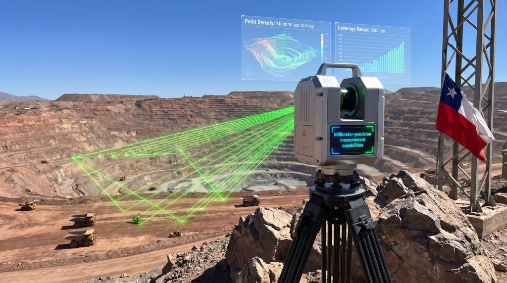
Contemporary mining operations demand monitoring solutions capable of detecting surface deformations invisible to conventional observation methods. LiDAR monitoring in Coquimbo mining applications demonstrates the technology's capacity to identify terrain variations measuring just centimetres in magnitude, providing early warning capabilities that traditional surveying cannot match.
The fundamental advantage lies in millimetre-precision measurement capabilities that enable detection of ground movements occurring over extended timeframes. Furthermore, data-driven mining operations in Chile's Coquimbo region, particularly those involving underground extraction at sites like Roxana and Tambor, require continuous assessment of surface stability where subsidence risks threaten operational safety and infrastructure integrity.
Core Technology Capabilities in Mining Environments
Remote sensing advantages eliminate the need for personnel exposure to unstable terrain zones, a critical consideration in areas where underground mining activities have created unpredictable ground conditions. SERNAGEOMIN's implementation of LiDAR technology in Quebrada Las Cañas exemplifies this approach, enabling comprehensive terrain assessment without compromising worker safety.
The technology generates three-dimensional data capture through systematic measurement of millions of surface points, creating detailed topographical models that reveal terrain characteristics invisible through conventional surveying methods. In addition, 3D geological modelling enhances understanding by providing detailed subsurface visualisation. Each scanning campaign produces comprehensive datasets enabling temporal comparison and change detection across operational areas.
Real-time monitoring potential supports immediate response protocols when significant terrain changes are detected, though implementation varies based on operational requirements and equipment specifications. The integration of continuous monitoring systems with existing safety protocols enables proactive intervention before critical thresholds are exceeded.
Mining Safety Challenge Applications
Underground extraction activities create specific monitoring requirements that LiDAR technology addresses through comprehensive surface analysis. Subsidence detection capabilities identify ground settlement patterns that may indicate void migration or geological instability affecting operational areas and surrounding infrastructure.
Slope stability assessment becomes particularly critical where open-pit and underground mining operations interface, creating complex geological conditions requiring continuous oversight. The technology's ability to detect subtle changes in terrain morphology enables early identification of potential slope failures or ground instability.
Volumetric change analysis tracks material displacement over time, providing quantitative data essential for geomechanical assessment and operational planning. This capability proves invaluable in determining whether observed terrain changes represent normal settling or indicate developing stability concerns.
When big ASX news breaks, our subscribers know first
Technical Implementation Framework for Mining LiDAR Systems
Successful deployment of LiDAR monitoring systems requires comprehensive understanding of technical specifications and operational parameters specific to mining environments. The precision capabilities demonstrated in LiDAR monitoring in Coquimbo mining applications—achieving centimetric accuracy through systematic point cloud generation—establish benchmark performance standards for similar implementations.
Equipment Specifications and Performance Parameters
| Parameter | Mining Application Range | Technical Considerations |
|---|---|---|
| Measurement Precision | 2-5 cm horizontal accuracy | Subsidence detection threshold |
| Point Density | 100,000-1,000,000 points/second | Comprehensive terrain characterisation |
| Coverage Range | 50-500 metres (terrestrial systems) | Site-specific positioning requirements |
| Vertical Accuracy | 5-10 cm depending on conditions | Slope stability assessment capability |
| Data Processing | Real-time to post-processing options | Integration with operational systems |
Terrestrial scanning stations positioned at strategic monitoring locations provide stable platforms for consistent data collection across survey campaigns. Site assessment determines optimal scanner placement, balancing comprehensive coverage with operator safety requirements and equipment accessibility.
Mobile LiDAR platforms extend coverage capabilities through vehicle-mounted or aerial systems, enabling efficient surveying of large operational areas. However, atmospheric conditions common in arid regions like Coquimbo—including dust and variable humidity—may affect measurement accuracy and require calibration adjustments.
Operational Deployment Methodologies
Integrated GPS positioning ensures accurate georeferencing essential for temporal change detection between successive survey campaigns. Network-corrected GPS systems increasingly supplement traditional positioning methods, improving coordinate accuracy and enabling precise comparison of multi-temporal datasets.
Multi-temporal analysis represents the core methodology for meaningful terrain change detection, as single-point measurements cannot distinguish actual terrain modification from measurement uncertainty. The protocol implemented at Quebrada Las Cañas follows established geotechnical monitoring practices:
- Baseline comprehensive scanning establishes initial terrain models for future comparison
- Periodic resurvey campaigns provide temporal datasets for change detection analysis
- Automated differencing algorithms identify elevation changes exceeding measurement thresholds
- Statistical validation confirms detected changes represent actual terrain modification
Point cloud processing workflows transform raw measurement data into actionable information for operational decision-making. Digital Elevation Model generation at specified resolutions enables visualisation and quantitative analysis of terrain changes across monitored areas.
Geotechnical Applications in Underground Mining Environments
Underground mining operations create unique geotechnical challenges requiring specialised monitoring approaches that address subsidence risks, infrastructure protection, and regulatory compliance requirements. LiDAR monitoring in Coquimbo mining demonstrates how advanced surveying technology addresses these complex operational demands.
Subsidence Monitoring and Early Warning Systems
Early warning systems integrate LiDAR-derived terrain data with geomechanical analysis to identify developing stability concerns before they reach critical thresholds. The monitoring protocol established for Roxana and Tambor mining operations exemplifies this proactive approach, where systematic terrain assessment supports predictive safety management.
SERNAGEOMIN's regulatory perspective emphasises that LiDAR technology enables detection of terrain variations at centimetric precision levels, facilitating early identification of potential safety risk scenarios. This capability proves essential in areas where underground extraction activities create void spaces that may propagate toward surface terrain.
Predictive modelling utilises temporal terrain data to forecast subsidence progression patterns, enabling operational teams to implement protective measures before infrastructure or safety threats materialise. Mineral exploration insights demonstrate how advanced monitoring supports resource evaluation while maintaining safety standards. The integration of high-resolution terrain monitoring with existing geomechanical assessment protocols enhances overall risk management capabilities.
Infrastructure Protection Protocols
Critical infrastructure identification prioritises monitoring efforts around essential operational assets including mine shafts, processing facilities, and transportation corridors. LiDAR monitoring establishes protective buffer zones where terrain changes trigger enhanced inspection protocols and potential operational modifications.
Multi-disciplinary coordination between geology, engineering, and operations teams becomes essential for effective interpretation of terrain monitoring data in underground mining contexts. The comprehensive datasets generated through systematic LiDAR scanning support integrated analysis incorporating:
- Geological structure assessment identifying bedrock conditions affecting subsidence potential
- Hydrological factor evaluation determining groundwater impacts on terrain stability
- Mining-induced stress analysis calculating extraction impacts on surrounding terrain
- Environmental compliance monitoring ensuring regulatory requirement fulfilment
Operational Response Integration
Emergency response optimisation leverages real-time terrain stability assessments to guide operational decisions during developing geological events. The capability to detect subsidence changes as small as 10-20mm over monitoring periods enables intervention before critical safety thresholds are exceeded.
Regulatory compliance requirements established by SERNAGEOMIN mandate comprehensive terrain monitoring in areas with significant underground mining activity. The agency's territorial analytics approach emphasises proactive risk identification through advanced monitoring technology implementation.
Regional Implementation: Coquimbo Mining Sector Analysis
The Coquimbo region presents unique geographical and geological characteristics that create both challenges and opportunities for advanced mining monitoring systems. Located in north-central Chile approximately 400 kilometres north of Santiago, the region encompasses terrain ranging from coastal plains to high-altitude Andean peaks, creating complex topographical conditions affecting mining operations.
Geographic and Geological Context
| Regional Parameter | Specification | Mining Implications |
|---|---|---|
| Climate Zone | Semi-arid (100-400mm annual precipitation) | Dust control requirements for optical systems |
| Elevation Range | 0-4,500+ metres | Variable atmospheric conditions |
| Primary Geology | Mixed sedimentary, metamorphic, igneous formations | Heterogeneous subsidence risk patterns |
| Mining Operations | Underground and open-pit combinations | Complex terrain interaction monitoring |
Underground extraction activities in the region create critical terrain stability monitoring requirements due to the interaction between mining-induced subsidence and natural geological processes. The combination of significant extraction depths and variable geological conditions necessitates comprehensive monitoring approaches capable of detecting subtle terrain changes across large operational areas.
Mining Industry Context and Applications
Roxana and Tambor operations represent typical underground mining scenarios where surface stability monitoring becomes essential for operational safety and regulatory compliance. These operations demonstrate how LiDAR monitoring in Coquimbo mining addresses the challenges created by underground void development and potential surface subsidence.
Regional mining characteristics include:
- Copper and molybdenum extraction through underground mining methods creating significant void spaces
- Precious metal operations requiring precision monitoring for high-value ore body extraction
- Mixed extraction methods combining underground and surface mining techniques
- Environmental sensitivity requiring comprehensive impact monitoring and mitigation
Quebrada Las Cañas monitoring area exemplifies the regional implementation approach, where systematic terrain assessment addresses the complex interaction between underground mining activities and surface stability. The monitoring protocol demonstrates integration of advanced surveying technology with established geotechnical assessment methods.
Regulatory Framework and Implementation
SERNAGEOMIN oversight emphasises leveraging advanced monitoring technology to ensure mining safety and environmental protection throughout the region. The agency's territorial analytics approach recognises that traditional monitoring methods may prove insufficient for detecting subtle terrain changes that precede significant geological events.
The regulatory perspective emphasises that comprehensive terrain monitoring enables geomechanical teams to anticipate risk scenarios, improving operational response capacity and supporting proactive intervention planning. This approach reflects the mining industry evolution towards predictive safety management rather than reactive incident response.
Environmental monitoring requirements incorporate terrain stability assessment as essential components of comprehensive impact evaluation. The integration of precise terrain monitoring with environmental compliance protocols ensures operational sustainability while maintaining safety standards.
Advanced Data Analysis and Interpretation Methods
Transforming raw LiDAR measurements into actionable operational intelligence requires sophisticated data processing methodologies specifically adapted for mining applications. The millions of measurement points captured during each survey campaign must undergo systematic analysis to identify meaningful terrain changes while filtering measurement noise and atmospheric effects.
Point Cloud Processing and Analysis Techniques
Digital elevation model generation converts raw point cloud data into grid-based terrain representations suitable for temporal comparison and volumetric analysis. Processing workflows incorporate statistical filtering to remove erroneous measurements while preserving legitimate terrain features essential for geotechnical assessment.
Difference analysis algorithms compare successive survey datasets to identify elevation changes exceeding measurement uncertainty thresholds. The statistical approach distinguishes actual terrain modification from measurement variability, ensuring detected changes represent genuine geological processes rather than systematic or random errors.
Change detection methodologies employed in Coquimbo mining applications utilise:
- Multi-temporal point cloud comparison identifying elevation differences across survey periods
- Morphological analysis detecting terrain shape modifications indicating geological processes
- Volumetric calculation quantifying material displacement for geomechanical assessment
- Statistical significance testing validating detected changes against measurement uncertainty
Integration with Mining Information Systems
Database integration links LiDAR-derived terrain data with operational records, geological information, and historical monitoring datasets. This comprehensive approach enables correlation analysis identifying relationships between mining activities and observed terrain changes.
Automated alert systems monitor processed terrain data for changes exceeding predetermined thresholds, triggering notification protocols for operational teams and regulatory oversight. The system design balances sensitivity requirements with false alarm minimisation through sophisticated statistical analysis.
Quality assurance procedures ensure data reliability through systematic validation protocols including:
- Calibration verification confirming measurement accuracy through control point assessment
- Temporal consistency analysis validating data quality across survey campaigns
- Cross-validation methods comparing LiDAR results with alternative monitoring techniques
- Metadata documentation maintaining comprehensive records of survey conditions and processing parameters
Economic and Operational Benefits Analysis
The implementation of LiDAR monitoring systems in mining operations requires comprehensive cost-benefit evaluation considering technology acquisition, operational expenses, and quantifiable safety improvements. The Coquimbo mining implementation demonstrates measurable advantages across multiple operational categories.
Cost-Benefit Framework Analysis
| Benefit Category | Specific Advantages | Quantifiable Impacts |
|---|---|---|
| Safety Enhancement | Reduced personnel exposure to unstable terrain | Decreased accident rates and insurance costs |
| Operational Efficiency | Remote monitoring eliminating access requirements | Reduced inspection time and equipment costs |
| Data Precision | Centimetric accuracy enabling early detection | Improved decision-making and response timing |
| Regulatory Compliance | Comprehensive documentation meeting oversight requirements | Reduced compliance costs and regulatory risk |
Technology acquisition costs for high-grade terrestrial LiDAR systems typically range from $200,000-$500,000 depending on specifications and vendor selection. However, operational cost savings through reduced personnel exposure, improved monitoring efficiency, and enhanced safety performance often justify initial investments within 2-3 years.
Return on investment considerations incorporate both direct cost savings and indirect benefits including enhanced operational reputation, improved regulatory relationships, and reduced insurance premiums resulting from demonstrated safety commitment.
Operational Efficiency Improvements
Remote monitoring capabilities eliminate requirements for personnel access to potentially unstable terrain areas, reducing operational risk while maintaining comprehensive oversight capabilities. This advantage proves particularly valuable in areas where underground mining activities have created unpredictable surface conditions.
Maintenance and calibration requirements for LiDAR systems prove minimal compared to traditional monitoring infrastructure, with annual maintenance costs typically representing 5-10% of initial system investment. Calibration protocols ensure continued measurement accuracy while minimising operational disruption.
Training program implementation builds internal technical capabilities enabling organisations to maximise monitoring system benefits. Investment in personnel development typically represents 10-15% of total implementation costs but proves essential for effective system utilisation.
The next major ASX story will hit our subscribers first
Future Developments and Technology Evolution
Mining industry adoption of LiDAR monitoring continues expanding as technology capabilities advance and costs decrease. The successful implementation in Coquimbo mining operations demonstrates the technology's maturation from specialised applications to mainstream operational tools.
Emerging Technology Capabilities
Artificial intelligence integration enables automated change detection algorithms that identify developing terrain instability patterns without requiring manual data analysis. Machine learning approaches can recognise subtle patterns in terrain behaviour that may escape traditional analytical methods.
Real-time processing capabilities reduce the temporal gap between data acquisition and operational decision-making, enabling immediate response to detected terrain changes. Advanced processing systems can generate preliminary analysis within hours of survey completion rather than requiring extended post-processing periods.
Enhanced precision technologies continue improving measurement accuracy, with next-generation systems approaching sub-millimetre precision under optimal conditions. These improvements enable detection of increasingly subtle terrain changes that may indicate developing geological processes.
Industry Adoption Trends and Implications
Regulatory driver acceleration reflects increasing mandatory monitoring requirements as agencies like SERNAGEOMIN recognise advanced monitoring technology benefits for mining safety oversight. This trend suggests expanding implementation requirements across Chilean mining operations.
Technology cost reduction makes LiDAR systems increasingly accessible to smaller mining operations previously unable to justify advanced monitoring investments. Equipment cost decreases of 20-30% over recent years have expanded the technology's economic viability.
Drone-based platform development expands monitoring coverage capabilities while reducing operational complexity and costs. Aerial platforms provide access to difficult terrain areas and enable efficient surveying of large operational zones.
Integration standardisation facilitates compatibility between different monitoring systems and operational databases, reducing implementation complexity and enabling more comprehensive data analysis across multiple monitoring technologies.
Implementation Best Practices and Recommendations
Successful LiDAR monitoring implementation requires systematic approach incorporating technical considerations, organisational preparation, and regulatory compliance requirements. The Coquimbo mining experience provides practical guidance for similar implementations.
Technical Setup and Deployment Guidelines
Site assessment protocols determine optimal scanner placement balancing comprehensive coverage with operational safety requirements and equipment accessibility. Assessment considers terrain characteristics, atmospheric conditions, and integration with existing monitoring infrastructure.
Calibration procedures ensure measurement accuracy through systematic validation against established control points and comparison with alternative surveying methods. Regular calibration maintains system precision while identifying potential equipment degradation requiring maintenance attention.
Data management systems must accommodate large-volume point cloud datasets while providing efficient access for analysis and reporting. Storage requirements typically range from gigabytes to terabytes per survey campaign depending on coverage area and point density specifications.
Organisational Integration Strategies
Cross-functional team formation incorporates personnel from geology, engineering, operations, and safety departments to ensure comprehensive monitoring programme implementation. Team composition should reflect the interdisciplinary nature of terrain monitoring and its operational implications.
Vendor partnership development ensures ongoing technical support, equipment maintenance, and software updates essential for sustained monitoring programme success. Professional surveying associations provide valuable resources for best practice guidance and technical standards.
Performance monitoring systems track implementation success through quantitative metrics including data quality, operational efficiency improvements, and safety performance enhancement. Regular assessment enables continuous improvement and demonstrates programme value to organisational leadership.
Regulatory Framework and Compliance Considerations
Chilean mining operations must navigate comprehensive regulatory requirements governing terrain stability monitoring, environmental impact assessment, and operational safety oversight. SERNAGEOMIN's approach to LiDAR monitoring in Coquimbo mining demonstrates integration of advanced technology with established regulatory frameworks.
Chilean Mining Safety Regulations
SERNAGEOMIN requirements for terrain stability monitoring emphasise proactive identification of potential safety hazards through comprehensive geological assessment. The agency's territorial analytics approach recognises advanced monitoring technology as essential for effective oversight of complex mining operations.
Environmental impact assessment integration ensures terrain monitoring programmes address both operational safety and environmental protection requirements. Monitoring protocols must demonstrate capability to detect terrain changes affecting surrounding ecosystems and water resources.
Reporting obligations require systematic documentation of monitoring results, detected terrain changes, and operational responses to identified hazards. Reports must demonstrate compliance with regulatory standards while providing technical justification for operational decisions.
Emergency response protocols triggered by monitoring results must integrate with broader operational safety systems and regulatory notification requirements. Response procedures should demonstrate clear escalation pathways and appropriate technical assessment capabilities.
International Standards and Best Practices
ISO guidelines for surveying and monitoring accuracy provide technical benchmarks ensuring measurement quality and consistency across different monitoring implementations. Compliance with international standards facilitates technology transfer and operational comparison.
Mining industry standards developed by organisations like the Society for Mining, Metallurgy & Exploration provide operational guidance for geotechnical monitoring implementation. These standards inform best practices while addressing industry-specific technical requirements.
Technology certification requirements ensure equipment reliability and measurement accuracy meeting operational and regulatory standards. Certification processes validate system performance under mining environment conditions including dust, vibration, and temperature variations.
Data security protocols protect sensitive operational information while enabling appropriate regulatory access and technical collaboration. Security frameworks must balance operational confidentiality with regulatory transparency requirements.
Technical Disclaimer: This analysis presents general information about LiDAR monitoring technology applications in mining environments. Specific implementation requirements, regulatory compliance obligations, and operational procedures should be verified with qualified technical professionals and appropriate regulatory authorities. Mining operations involve inherent risks requiring comprehensive safety assessment and professional oversight.
The evolution of terrain monitoring technology in Chilean mining operations reflects broader industry transformation toward predictive safety management and data-driven operational decision-making. As demonstrated through the Coquimbo region implementation, advanced monitoring systems provide essential capabilities for managing complex geological conditions while meeting increasing regulatory expectations for operational safety and environmental protection.
Could Advanced LiDAR Monitoring Unlock Your Next Mining Investment Opportunity?
The precision terrain monitoring capabilities demonstrated in Chile's Coquimbo region represent just one example of how technological advancement drives value creation in modern mining operations. Discovery Alert's proprietary Discovery IQ model instantly identifies ASX mining discoveries where companies deploy such cutting-edge technologies, delivering real-time alerts to subscribers seeking actionable investment opportunities in innovative mining operations. Begin your 14-day free trial today to position yourself ahead of the market when the next technology-driven mining discovery is announced.