May 22, 2026
The Terrain Shapes the Technology: Why Argentina's Resource Complexity Is Forcing a Digital Reckoning
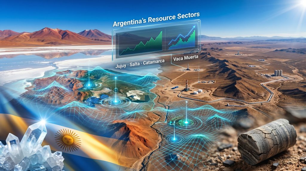
When geologists probe the high-altitude salt flats of Argentina's Puna plateau at elevations exceeding 3,500 metres, or when engineers manage the intricately fractured shale layers of Vaca Muerta thousands of metres below Patagonia's surface, the data challenge is not abstract. It is physical, immediate, and operationally consequential. The reason mining and oil drive GIS and AI adoption in Argentina more aggressively than in comparable economies has nothing to do with a technology trend. It has everything to do with the nature of the ground itself.
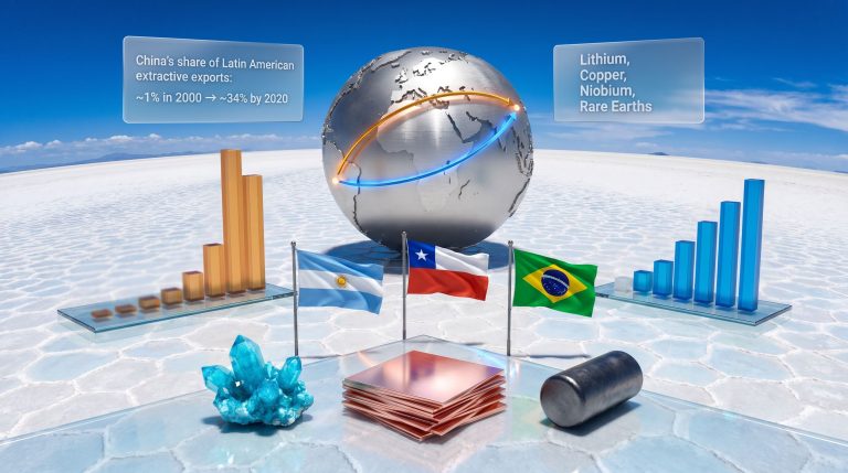
Argentina sits at an unusual intersection of resource endowments. It holds the world's second-largest shale gas reserves and fourth-largest shale oil reserves according to the U.S. Energy Information Administration, most of them concentrated in the Vaca Muerta formation. Simultaneously, it forms the apex of the so-called Lithium Triangle alongside Chile and Bolivia, containing an estimated 21% of global known lithium reserves. These two resource categories, separated geographically but linked commercially, are generating a structural and sustained demand for geospatial intelligence and artificial intelligence that is reshaping how the country's extractive industries operate at a foundational level.
When big ASX news breaks, our subscribers know first
Resource Complexity as the True Engine of Technology Demand
Understanding why GIS and AI adoption in Argentina follows a different trajectory than in service-led economies requires a clear-eyed look at what resource operators are actually confronting on the ground.
Argentina lithium brines are not conventional hard-rock mineralisation. The primary lithium source across Jujuy, Salta, and Catamarca provinces is brine, concentrated subsurface saltwater saturated with lithium chloride that sits beneath the surface of evaporite basins called salars. Extracting and processing this brine requires precise spatial modelling of:
- Brine aquifer geometry and depth variation across the salar footprint
- Lithium grade distribution within the brine column, which can vary significantly across short lateral distances
- Evaporation pond placement and efficiency relative to solar radiation, wind exposure, and topographic gradient
- Environmental boundary management around fragile high-altitude wetland ecosystems, including flamingo habitat and freshwater springs
Each of these requirements demands high-resolution spatial data management. A GIS platform that cannot integrate subsurface brine modelling with surface topographic surveys and environmental compliance boundaries is operationally inadequate for Argentina's lithium context. This is not a question of technological aspiration. It is, however, a matter of operational survival.
The Salar Environment: A Data Challenge Unlike Any Other in Mining
What makes the lithium salar environment particularly demanding from a data perspective is the extreme sensitivity of brine grade to spatial position. Unlike a gold deposit where ore grades vary across rock volumes that can be physically sampled by drilling, lithium brine grade in a salar can shift materially across horizontal distances of just a few hundred metres due to subsurface hydrogeological heterogeneity.
This means exploration and resource estimation require dense spatial sampling networks integrated into three-dimensional hydrogeological models. Furthermore, this is precisely the kind of problem that modern GIS platforms coupled with machine learning interpolation techniques are built to address. Indeed, lithium brine extraction methods have evolved considerably as operators seek to manage this spatial complexity more effectively.
The lithium grade quality dimension also carries direct commercial implications. Lithium carbonate equivalent grades in Argentine salars typically range between 200 and 800 milligrams per litre of brine, with projects at the higher end, such as those in the Jama and Cauchari-Olaroz areas of Jujuy, considered economically superior. AI-assisted spatial modelling that can identify high-grade brine zones within a salar footprint can materially improve project economics by directing early production infrastructure toward the richest brine bodies.
Vaca Muerta's Data Intensity: A Different Kind of Spatial Problem
Unconventional hydrocarbon development at Vaca Muerta operates on a data scale that dwarfs most other industrial environments in Latin America. A single hydraulic fracturing operation across a horizontal well in the Vaca Muerta shale generates thousands of real-time data points across pressure, temperature, fluid injection rates, and microseismic activity. Multiply this across the hundreds of wells drilled annually across the Neuquén basin and the data volume becomes structurally unmanageable without AI-assisted analytics and GIS-based spatial organisation.
The specific AI applications reshaping Vaca Muerta operations include:
- Seismic facies classification using neural networks trained on existing well log and core data, enabling geologists to predict productive zones in undrilled areas with greater confidence than deterministic interpretation alone
- Completion optimisation where AI models analyse the relationship between hydraulic fracture design parameters and well production outcomes across thousands of historical well datasets to improve future frac design
- Decline curve analysis using machine learning to project long-term production trajectories with tighter uncertainty bounds than conventional Arps decline models
- Predictive maintenance for compression equipment, pumping units, and pipeline systems operating across remote terrain where unplanned downtime carries significant logistical cost
In addition, direct lithium extraction technologies are increasingly drawing on similar AI-driven analytical frameworks to optimise yield. Consequently, the methodological crossover between hydrocarbon and lithium operations is becoming more pronounced as both sectors mature.
The convergence of high data density, remote operating conditions, and the economic sensitivity of completion decisions in tight rock formations makes Vaca Muerta one of the most compelling natural laboratories for AI deployment in the global oil and gas industry.
How 3D Modelling Is Transforming Subsurface Intelligence
3D geological modelling has become an indispensable tool across both Argentina's lithium and hydrocarbon sectors. By integrating seismic interpretation, well log data, and surface mapping into unified three-dimensional subsurface representations, operators are able to make better-informed drilling and resource development decisions. According to research on AI adoption in mining and natural resources, strategic challenges remain even as adoption advances, particularly around data integration and model validation at scale.
Argentina's Structural Advantages as a Regional AI Infrastructure Candidate
Beyond operational field applications, a less widely discussed dimension of Argentina's technology story involves its potential as a host for large-scale AI computing infrastructure. The energy profile required to power data centres capable of training and running large AI models is substantial, and Argentina's energy mix offers structural advantages that few Latin American economies can match:
| Energy Source | Location | Relevance to AI Infrastructure |
|---|---|---|
| Shale gas (Vaca Muerta) | Neuquén province | Low-cost, abundant power generation feedstock |
| Wind energy | Patagonia coastal corridor | Among the world's highest-capacity wind resources |
| Hydroelectric | Andean foothills, Patagonia rivers | Established baseload renewable generation |
| Nuclear | Buenos Aires province (Atucha), Córdoba (Embalse) | Reliable low-carbon baseload capacity |
| Cold climate | Patagonian plateau | Reduces data centre cooling costs materially |
The cold climate advantage deserves particular attention. Data centre cooling typically represents 30 to 40 percent of total energy consumption in warm climate environments. Patagonia's average temperatures reduce this burden substantially, creating a structural operating cost advantage for AI computing facilities that most equatorial and subtropical Latin American locations cannot replicate.
Argentina's RIGI investment incentive framework provides a structured pathway for attracting large-scale capital into qualifying projects. However, analysts have noted that the minimum investment thresholds within RIGI create a differentiated access landscape: very large AI infrastructure investments may benefit from the regime's provisions, while mid-tier technology deployments are likely to fall outside eligibility parameters. This structural gap in policy coverage is an underappreciated constraint on Argentina's broader AI ecosystem development.
The Operational Constraints Holding Back Full-Scale Deployment
Despite the clarity of demand signals, the gap between Argentina's technology potential and its current deployment depth reflects a set of supply-side constraints that are less visible than the headline resource statistics but equally consequential:
Workforce skills misalignment: Argentina's geology and petroleum engineering universities produce strong technical graduates, but the intersection of geoscience competency and data science capability remains underpopulated. Operators in remote provinces frequently report difficulty retaining GIS and AI specialists who prefer urban employment conditions.
Legacy data quality limitations: Argentina's national geological survey holds extensive historical datasets accumulated over decades of public-sector exploration. However, inconsistent sampling methodologies, variable documentation standards, and limited digital formatting in older records reduce the utility of this data as training material for AI models. Poor training data produces unreliable models, a technical constraint that is easy to underestimate from the outside.
Connectivity in remote environments: High-altitude salar operations in the Puna frequently sit beyond reliable mobile network coverage and satellite connectivity bandwidth. Edge computing architectures, where data processing occurs locally at the sensor rather than in centralised cloud infrastructure, are gaining traction as a partial solution. However, deployment at scale across Argentina's diverse operating environments remains an ongoing engineering challenge.
Regulatory fragmentation: Argentina's federal structure distributes resource jurisdiction across provincial governments, creating overlapping and sometimes inconsistent regulatory frameworks for environmental monitoring data, indigenous land consultation mapping, and resource boundary reporting. GIS platforms that must satisfy multiple provincial data standards simultaneously face interoperability demands that increase implementation cost and complexity. Furthermore, predictive maintenance systems deployed across these environments must account for the added complexity of fragmented data governance when designing remote monitoring architectures.
How Argentina Compares Across the Regional Technology Adoption Landscape
Within Latin America's extractive technology picture, Argentina occupies a distinctive position driven by the simultaneous intensity of both its hydrocarbon and critical minerals sectors. Most regional peers are characterised by dominance in a single resource category. For instance, energy companies across Latin America are increasingly deepening AI adoption, though at varying rates depending on their resource base and institutional capacity:
- Chile has advanced GIS and AI deployment in copper mining but limited unconventional hydrocarbon exposure
- Brazil leads in offshore oil technology and agricultural spatial analytics but its hard-rock mining AI adoption lags the pace of its pre-salt basin digital transformation
- Colombia is developing onshore hydrocarbon AI capabilities but its critical minerals sector is at an earlier stage of technology integration
- Mexico is modernising national oil company data systems but faces institutional constraints that slow commercial AI adoption
Argentina's dual resource profile means that technology providers serving the country must build platforms capable of handling both subsurface brine hydrogeology and unconventional shale analytics. This combined requirement is creating demand for genuinely sophisticated multi-domain GIS and AI solutions rather than single-sector point tools.
The next major ASX story will hit our subscribers first
The Technology Multiplier: What GIS and AI Adoption Means Beyond the Wellhead
The longer-term economic significance of mining and oil drive GIS and AI adoption in Argentina may ultimately reside less in individual project efficiency gains and more in the structural development of a domestic technology capability with regional export potential.
As Argentine operators develop in-house expertise in spatial data management, AI model training on resource datasets, and IoT integration across remote field environments, they accumulate institutional knowledge that is genuinely scarce across Latin America. Technology service companies, data platform providers, and geospatial consultancies that establish deep operational roots in Argentina's resource sector are building capabilities that are directly transferable to comparable environments across the Andes, the Amazon basin, and the Orinoco belt.
The most consequential long-term outcome of Argentina's technology adoption trajectory may not be measured in barrels of oil or tonnes of lithium carbonate equivalent. It may be measured in the depth of the domestic technology ecosystem that forms around the country's resource complexity.
Disclaimer: This article contains forward-looking analysis and projections based on publicly available industry data and structural market assessments. It does not constitute financial or investment advice. Readers should conduct independent research and seek professional guidance before making investment decisions related to any sector or company discussed.
Want to Stay Ahead of the Next Major Mineral Discovery?
Discovery Alert's proprietary Discovery IQ model delivers real-time alerts on significant ASX mineral discoveries — instantly translating complex geological and commodity data into actionable investment insights for both short-term traders and long-term investors. Explore Discovery Alert's discoveries page to see the historic returns major mineral discoveries have generated, and begin your 14-day free trial today to position yourself ahead of the broader market.