May 22, 2026
Understanding Modern Geohazard Monitoring Platform Architecture
The evolution of geotechnical monitoring in mining operations reflects a fundamental shift from reactive safety protocols to predictive risk management systems. Traditional approaches relied heavily on manual inspections and basic instrumentation, creating vulnerability gaps that modern operations cannot afford. Today's data-driven mining operations demand continuous, automated surveillance capable of detecting subsurface movements measured in millimetres across vast operational areas.
Core Radar Technology Integration Fundamentals
Real Aperture Radar (RAR) systems operate through direct beam measurement, providing immediate detection capabilities for rapid-response scenarios. These systems excel in applications requiring instant threat assessment but face coverage limitations due to their fixed beam characteristics. Synthetic Aperture Radar (SAR) technology overcomes these constraints by employing sophisticated signal processing algorithms that synthesise larger effective antenna apertures, enabling broader coverage with enhanced resolution.
Doppler radar applications complement both RAR and SAR systems by measuring velocity components of ground movement, providing critical early warning indicators for accelerating slope failures. The integration of these three radar technologies creates a comprehensive detection matrix that addresses different temporal and spatial monitoring requirements across mining operations.
Multi-sensor fusion capabilities represent the technological backbone enabling diverse monitoring equipment to operate as unified systems. Modern platforms achieve this integration through standardised communication protocols that translate proprietary sensor outputs into common data formats. These protocols ensure that piezometers measuring groundwater pressure, GNSS networks tracking millimetre-scale positional changes, and optical cameras providing visual verification can contribute simultaneously to threat assessment algorithms.
Software Platform Requirements for Mining Operations
Contemporary monitoring platforms must accommodate the complex integration demands of modern mining operations while maintaining operational reliability under harsh environmental conditions. The software architecture supporting these systems requires robust database management capabilities, real-time processing engines, and flexible alert configuration tools that adapt to site-specific risk profiles.
| Integration Type | Data Sources | Real-time Processing | Alert Systems |
|---|---|---|---|
| Radar Systems | RAR, SAR, Doppler | Sub-minute updates | Multi-threshold |
| GNSS Networks | Survey-grade positioning | Continuous tracking | Movement vectors |
| Third-party Sensors | Piezometers, cameras | Variable intervals | Customisable |
Platform reliability depends heavily on redundant processing capabilities and fail-safe communication protocols. Mining operations cannot tolerate monitoring system downtime, particularly during periods of elevated geotechnical risk. Consequently, modern software architectures incorporate distributed processing capabilities that maintain functionality even when individual components experience failures.
When big ASX news breaks, our subscribers know first
What Makes Next-Generation Monitoring Systems Different?
The distinction between current-generation and next-generation GroundProbe geohazard monitoring platform capabilities centres on fundamental advances in computational geometry and predictive analytics. Traditional systems required specific geometric relationships between sensors and monitored slopes, limiting deployment flexibility and creating blind spots in complex topographical environments.
Advanced 3D Modelling and Geometry-Independent Analysis
Geometry-independent measurement capabilities eliminate the constraints that previously limited monitoring system placement and effectiveness. Traditional radar systems required optimal beam angles relative to slope orientations to achieve accurate displacement measurements. Modern systems overcome these limitations through advanced signal processing algorithms that compensate for suboptimal geometric relationships while maintaining measurement precision.
Real-time 3D geological modeling transforms static monitoring data into dynamic visualisation tools that operators can use for immediate threat assessment. These systems continuously update three-dimensional representations of monitored areas, highlighting movement patterns and accelerating displacement trends that might indicate impending failures. The computational requirements for real-time 3D processing demand edge computing capabilities deployed directly at monitoring sites to minimise latency.
Three-dimensional visualisation capabilities extend beyond simple displacement mapping to include volumetric analysis of potential failure zones. Modern systems calculate sliding mass estimates, predict runout distances, and assess impact zones for infrastructure and personnel safety planning. This analytical depth enables proactive evacuation planning and operational adjustments before critical thresholds are reached.
Predictive vs Reactive Monitoring Strategies
Predictive monitoring systems operate on continuous surveillance principles, maintaining constant observation of slope stability indicators and trending movement patterns over extended periods. These systems excel at detecting gradual acceleration phases that precede catastrophic failures, providing operators with advance warning periods measured in hours or days rather than minutes.
Reactive monitoring systems prioritise rapid deployment capabilities for emergency response scenarios. When unexpected geological events occur or mining activities create sudden stability changes, reactive systems can be positioned and calibrated quickly to assess immediate threats. These systems emphasise portability, rapid installation procedures, and immediate threat detection rather than long-term trend analysis.
Hybrid monitoring approaches combine both methodologies through coordinated system deployments that maintain permanent predictive surveillance while retaining rapid-response capabilities for emerging threats. This dual-layer strategy provides comprehensive coverage that adapts to changing operational conditions and unexpected geological developments.
How Do Mining Operations Select Optimal Monitoring Configurations?
Configuration selection for geohazard monitoring systems requires comprehensive assessment of site-specific geological conditions, operational characteristics, and risk tolerance levels. Different mining operations present distinct monitoring challenges that influence technology selection and deployment strategies.
Site-Specific Assessment Criteria
Open-pit mining operations face unique monitoring challenges related to large-scale slope stability across multiple benches and varying geological formations. These operations require broad-coverage monitoring systems capable of detecting movement across hundreds of metres while maintaining sufficient resolution to identify localised failure initiation points. Weather exposure presents additional considerations for equipment durability and measurement consistency.
Underground mining operations prioritise monitoring systems focused on critical support structures, entry points, and areas where surface subsidence might affect operations. The monitoring requirements emphasise precision measurement of specific structural elements rather than broad-area surveillance. Integration with existing underground communication and power infrastructure becomes a primary consideration for system selection.
Tailings facility monitoring demands specialised approaches due to the catastrophic consequences of embankment failures. These operations require continuous surveillance of dam integrity, seepage detection, and foundation stability. The monitoring systems must provide redundant measurement capabilities and direct integration with emergency response protocols. Regulatory compliance requirements often dictate specific monitoring standards and reporting capabilities.
Coverage Area and Resolution Trade-offs
Tactical high-resolution monitoring focuses on critical safety zones where personnel exposure or infrastructure vulnerability creates elevated risk scenarios. These deployments prioritise measurement precision and detection sensitivity over broad coverage areas. Typical applications include active mining faces, populated areas, and critical infrastructure locations where early warning capabilities directly impact safety outcomes.
Strategic broad-area coverage provides comprehensive site surveillance across entire mining operations, enabling operators to identify emerging threats in previously stable areas. These systems emphasise coverage breadth over individual measurement precision, creating safety nets that detect unexpected geological developments. The integration of multiple strategic monitoring points creates overlapping coverage zones that eliminate blind spots.
Mobile monitoring solutions address the dynamic nature of active mining operations where extraction activities continuously alter the geological environment. These systems provide flexibility for monitoring newly exposed slopes, temporary infrastructure, and transitional operational areas. Mobile deployments require rapid installation capabilities, wireless communication protocols, and integration procedures that minimise disruption to ongoing operations.
Platform Integration and Data Management Capabilities
Effective geohazard monitoring depends on seamless integration between diverse sensor technologies and data management systems that transform raw measurements into actionable intelligence. Modern mining operations employ equipment from multiple vendors, creating integration challenges that demand sophisticated middleware solutions and standardised communication protocols.
Multi-Vendor Sensor Integration Architecture
Standardised data protocols enable integration across different manufacturers' sensor systems through common communication frameworks and data formatting standards. Industry-standard protocols such as OPC UA (Open Platform Communications Unified Architecture) and MQTT (Message Queuing Telemetry Transport) provide the technical foundation for multi-vendor integration. These protocols translate proprietary sensor outputs into standardised formats that monitoring platforms can process uniformly.
Legacy system compatibility presents ongoing challenges as mining operations upgrade monitoring capabilities while maintaining existing infrastructure investments. Migration strategies must address data continuity requirements, ensuring that historical trend data remains accessible during system transitions. Modern platforms incorporate translation interfaces that enable communication with older monitoring equipment while providing upgrade paths for enhanced capabilities.
Real-time data aggregation and processing workflows coordinate inputs from multiple sensor types, applying quality assurance algorithms and correlation analysis to validate measurement accuracy. These systems must process data streams with varying update frequencies and measurement characteristics while maintaining synchronisation for coordinated threat assessment.
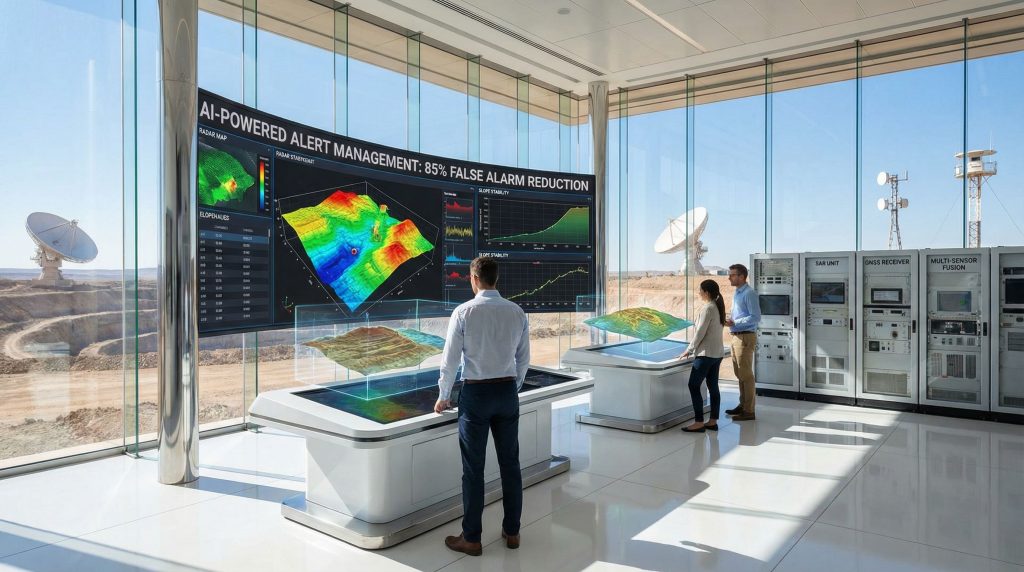
Alert Management and False Positive Reduction
Advanced alert management systems employ machine learning algorithms and multi-sensor correlation techniques to significantly reduce false alarm rates. Furthermore, AI in mining operations analyse patterns across multiple sensor inputs, weather conditions, and operational activities to distinguish between genuine threats and measurement anomalies caused by equipment vibration, environmental factors, or routine mining activities.
Modern geohazard monitoring systems demonstrate the capability to reduce false alarm incidents through sophisticated pattern recognition that correlates movement data with operational activities, weather patterns, and equipment status to validate threat assessments.
Multi-threshold alert configurations enable graduated response protocols that escalate warnings based on threat severity and confidence levels. Initial alerts may trigger increased monitoring frequency and operational awareness, while higher-level alerts activate evacuation procedures and equipment shutdown protocols. This graduated approach prevents unnecessary operational disruptions while ensuring appropriate response to genuine threats.
Operator notification mechanisms integrate with existing mine communication systems, ensuring that alerts reach appropriate personnel through multiple channels. Modern systems support integration with mobile devices, public address systems, and automated equipment shutdown systems to guarantee timely response to critical warnings.
Deployment Considerations for Modern Monitoring Platforms
Successful implementation of next-generation GroundProbe geohazard monitoring platform systems requires careful attention to site preparation, installation procedures, and ongoing maintenance protocols. The complexity of modern monitoring systems demands systematic deployment approaches that ensure reliable operation under challenging mining environments.
Installation and Commissioning Requirements
Site preparation involves comprehensive assessment of installation locations, considering factors such as equipment accessibility, power availability, communication infrastructure, and environmental exposure. Modern radar systems require stable mounting platforms that minimise vibration interference while providing optimal coverage of monitored areas. Foundation design must account for equipment weight, wind loading, and thermal expansion effects that could affect measurement accuracy.
Calibration procedures for multi-radar networks involve establishing coordinate systems that enable correlation between different sensor measurements and integration with existing site mapping data. This process includes verification of measurement accuracy through comparison with known reference points and validation of detection capabilities using controlled test scenarios.
Integration with existing mine communication infrastructure requires assessment of network capacity, latency requirements, and redundancy protocols. Modern monitoring systems generate substantial data volumes that must be transmitted reliably to central processing locations. Backup communication pathways ensure monitoring continuity during primary network disruptions.
Operational Maintenance and Support Models
24/7 global monitoring centre capabilities provide continuous oversight of system performance and immediate response to equipment malfunctions or alert conditions. GroundProbe's global monitoring services employ specialised technicians trained in geotechnical monitoring principles and equipped with remote diagnostic tools that enable troubleshooting without site visits. Global coverage ensures that support personnel are available regardless of local time zones or site locations.
Remote diagnostic and troubleshooting protocols enable rapid response to equipment issues through network-based system access. Modern monitoring platforms incorporate self-diagnostic capabilities that continuously monitor sensor performance, communication status, and data quality indicators. Automated alerts notify support personnel when preventive maintenance becomes necessary or when equipment performance degrades.
Preventive maintenance scheduling and sensor lifecycle management require systematic tracking of equipment performance trends and replacement cycles. Mining environments present harsh operating conditions that accelerate equipment wear, making proactive maintenance essential for system reliability. Modern platforms maintain detailed equipment history databases that enable predictive maintenance scheduling based on actual performance data rather than arbitrary time intervals.
Cost-Benefit Analysis Framework for Geohazard Monitoring Investment
Evaluating geohazard monitoring system investments requires comprehensive analysis of direct costs, operational benefits, and risk mitigation value. Mining operations must consider both quantifiable financial impacts and qualitative safety improvements when assessing monitoring technology investments.
Direct Cost Factors
Equipment procurement and installation costs include radar systems, supporting infrastructure, communication equipment, and installation services. Modern monitoring platforms represent significant capital investments, with costs varying based on coverage requirements, system complexity, and site-specific installation challenges. Total system costs typically include multiple radar units, central processing equipment, and redundant communication systems.
Software licensing and ongoing support represent substantial operational expenses that continue throughout system lifecycle. Modern monitoring platforms operate on subscription-based models that include software updates, technical support, and access to global monitoring centres. These recurring costs must be evaluated against the operational benefits and risk reduction provided by continuous monitoring capabilities.
Personnel training and certification requirements ensure that operational staff can effectively utilise monitoring system capabilities and respond appropriately to alert conditions. Training programmes must address system operation, data interpretation, emergency response procedures, and maintenance protocols. Ongoing training ensures that personnel remain current with system updates and evolving best practices.
Risk Mitigation Value Quantification
Production downtime prevention represents the most direct quantifiable benefit of effective geohazard monitoring. Slope failures can halt mining operations for extended periods, resulting in lost production revenue that often exceeds monitoring system costs within single incident scenarios. Effective monitoring enables proactive operational adjustments that maintain production continuity while ensuring safety.
Personnel safety risk reduction provides immeasurable value through prevention of injuries and fatalities that could result from undetected slope failures. Beyond the human cost, safety incidents create substantial financial liabilities including medical expenses, compensation claims, regulatory penalties, and operational disruptions. Insurance companies increasingly recognise effective monitoring as risk reduction measures that qualify for premium reductions.
Regulatory compliance benefits include demonstration of due diligence in safety management and adherence to evolving monitoring standards. Regulatory agencies worldwide increasingly require comprehensive monitoring for high-risk mining operations, making monitoring systems essential for maintaining operating permits. Proactive monitoring implementation demonstrates commitment to safety that supports regulatory relationships and permit renewals.
The next major ASX story will hit our subscribers first
Future Technology Trends in Geohazard Monitoring
Technological advancement continues to reshape geohazard monitoring capabilities through integration of artificial intelligence, enhanced sensor technologies, and improved communication systems. However, these developments promise to further enhance monitoring effectiveness while reducing operational complexity and costs.
Artificial Intelligence and Machine Learning Integration
Predictive failure modelling using historical data patterns enables monitoring systems to identify subtle precursor indicators that precede slope failures. Machine learning algorithms analyse vast datasets of previous incidents, correlating measurement patterns with eventual outcomes to improve early warning capabilities. These systems continuously refine their predictive accuracy through ongoing data collection and outcome validation.
Automated threat assessment and response protocols reduce dependence on human interpretation of monitoring data while ensuring consistent response to threat conditions. AI systems can process multiple data streams simultaneously, applying complex correlation algorithms that exceed human analytical capabilities. Automated systems provide continuous vigilance that doesn't suffer from fatigue, distraction, or shift changes that affect human operators.
Enhanced pattern recognition capabilities enable detection of complex geological behaviours that manifest through subtle measurement combinations rather than obvious single-parameter changes. Advanced algorithms identify patterns across multiple sensors, time periods, and environmental conditions that indicate developing instability. This sophisticated analysis capability improves detection sensitivity while reducing false alarm rates.
IoT and Edge Computing Developments
Distributed processing capabilities at sensor level reduce communication bandwidth requirements and improve system response times through local data processing. Edge computing enables sophisticated analysis functions to operate at monitoring sites, reducing dependence on central processing systems and improving reliability during communication disruptions. Local processing capabilities also enable immediate response to critical conditions without waiting for central system analysis.
Reduced latency for critical safety applications improves emergency response times through immediate threat detection and alert generation. Edge computing systems can implement automated shutdown procedures and evacuation alerts without waiting for communication with central control systems. This distributed intelligence ensures that critical safety functions remain operational even during network failures.
Enhanced connectivity options for remote mining locations include satellite communication systems, cellular networks, and mesh networking protocols that provide reliable communication in challenging environments. Modern monitoring systems incorporate multiple communication pathways that automatically switch between available networks to maintain continuous data transmission and remote system access.
Implementation Best Practices and Lessons Learned
Successful geohazard monitoring implementation requires systematic planning, phased deployment strategies, and ongoing optimisation based on operational experience. In addition, mining industry innovation emphasises comprehensive preparation, gradual system deployment, and continuous improvement approaches that maximise monitoring effectiveness.
Phased Deployment Strategies
Pilot programme design enables validation of monitoring system capabilities under actual operational conditions before committing to full-scale deployment. Pilot implementations should focus on representative areas that demonstrate system performance across different geological conditions and operational scenarios. Success metrics must include detection accuracy, false alarm rates, integration effectiveness, and operational impact assessment.
Scalability planning for mine expansion ensures that initial monitoring system investments can accommodate future operational growth and changing monitoring requirements. System architecture should incorporate expansion capabilities that enable additional sensors, broader coverage areas, and enhanced processing capabilities without requiring complete system replacement. Modular design approaches facilitate cost-effective expansion as operations develop.
Change management for operational teams addresses the human factors involved in implementing new monitoring technologies and procedures. Successful implementation requires comprehensive training programmes, clear operating procedures, and ongoing support that helps personnel adapt to new technologies. Resistance to change can undermine monitoring effectiveness if not addressed through proper change management protocols.
Performance Optimisation Techniques
The most effective geohazard monitoring implementations combine tactical high-resolution systems for critical areas with strategic broad-coverage solutions, achieving comprehensive site protection while optimising operational efficiency. This hybrid approach ensures that limited monitoring resources are allocated optimally across different risk scenarios and operational requirements.
Continuous performance monitoring and system optimisation ensure that monitoring capabilities remain effective as operational conditions change and equipment ages. Regular performance reviews should assess detection accuracy, false alarm trends, coverage effectiveness, and integration performance. Optimisation procedures address identified deficiencies through equipment adjustments, software updates, or deployment modifications.
Integration with operational planning processes ensures that monitoring data influences mining decisions and helps optimise extraction sequences for enhanced safety. Furthermore, drill results interpretation should inform blast design, bench development, equipment routing, and personnel deployment decisions. This integration transforms monitoring from reactive safety measure to proactive operational tool that enhances both safety and efficiency.
The next-generation GroundProbe geohazard monitoring platform represents a significant advancement in mining safety technology, offering unprecedented capabilities for comprehensive geohazard detection and prevention. For instance, Orica's latest geohazard monitoring innovations demonstrate how these systems are transforming industry safety standards across global mining operations.
Investment Disclaimer: This article contains forward-looking statements and technical analysis that may not reflect actual operational outcomes. Geohazard monitoring technology performance depends on site-specific conditions, proper implementation, and ongoing maintenance. Mining operations should conduct comprehensive technical and financial evaluations before implementing monitoring systems. The effectiveness of monitoring technologies may vary based on geological conditions, equipment configuration, and operational procedures that differ across mining sites.
Interested in Identifying the Next Major Mineral Discovery?
Discovery Alert instantly alerts investors to significant ASX mineral discoveries using its proprietary Discovery IQ model, turning complex mineral data into actionable insights for smart investment decisions. Understand why historic discoveries can generate substantial returns by exploring the track records of major finds, then begin your 14-day free trial to position yourself ahead of the market with real-time discovery notifications.