May 22, 2026
Modern Mineral Detection Technologies Address Canadian Mining Complexities
Canada's vast geological terrains contain untapped mineral wealth hidden within increasingly complex subsurface environments. Traditional exploration methods struggle to penetrate deep structural systems, particularly in regions where conventional surveying faces physical constraints. Advanced multiphysics imaging technologies now offer solutions to these longstanding challenges, enabling explorers to map intricate geological formations with unprecedented precision.
The evolution of exploration technology reflects the mining industry evolution need to access deeper, more structurally complex deposits. As surface and near-surface resources become depleted, companies must develop sophisticated methods to locate buried mineral systems hundreds of metres below ground. This technological advancement proves essential in maintaining competitive mineral discovery programs across Canada's diverse geological provinces.
When big ASX news breaks, our subscribers know first
Revolutionary Multiphysics Integration Transforms Subsurface Mapping
Fleet Space Technologies' ExoSphere platform represents a breakthrough in real-time geological imaging, combining passive seismic monitoring with gravity and magnetic measurements. This integrated approach generates three-dimensional subsurface models instantly, eliminating traditional delays between data collection and interpretation phases.
The system's modular deployment capabilities allow operations in challenging terrain where conventional line-based surveys prove impossible. Traditional geophysical methods require clear access corridors, often necessitating vegetation clearing and environmental disturbance. ExoSphere's flexible sensor networks adapt to natural obstacles, including water bodies, steep terrain, and environmentally sensitive areas.
Technical Architecture Components
• Passive seismic arrays detect subtle velocity variations in subsurface materials
• Integrated gravity measurements map density contrasts indicating structural features
• Magnetic sensors identify mineralisation-related magnetic anomalies
• Real-time data processing enables immediate decision-making during field operations
The technology's depth penetration capabilities exceed 400 metres in complex geological environments, surpassing many traditional survey methods. This extended reach proves crucial for unconformity-related deposits, which frequently occur at depths beyond conventional exploration ranges.
Structural Complexity Challenges in Unconformity-Related Systems
Unconformity-related uranium deposits present unique detection challenges due to their geometric characteristics and geological settings. These systems develop where basement rocks contact overlying sedimentary sequences, creating narrow, fault-controlled mineralisation zones that traditional surveys often miss.
The Athabasca Basin exemplifies these exploration difficulties, hosting world-class uranium grades within structurally complex environments. Furthermore, deposits typically exhibit irregular alteration patterns that mask conventional geochemical signatures, requiring sophisticated structural mapping to identify prospective zones.
Exploration Constraints in Complex Terrain
- Narrow deposit geometries create small exploration targets difficult to detect
- Deep burial depths exceeding 300-400 metres challenge conventional survey penetration
- Fault-controlled mineralisation demands precise structural understanding
- Environmental obstacles prevent traditional line-based geophysical access
Traditional exploration approaches rely on static data collection methods that provide limited real-time decision support. Single-physics survey techniques miss critical subsurface relationships, particularly the complex structural controls governing uranium market dynamics in unconformity settings.
Fleet Space's ExoSphere Drill Results Canada: Perch River Project Validation
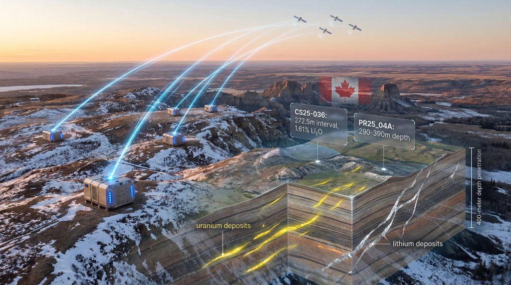
The Perch River Uranium Property in Saskatchewan's Athabasca Basin demonstrates ExoSphere's effectiveness in challenging geological environments. Initial soil and radon sampling had identified anomalous uranium, nickel, lead isotopes, and rare earth elements, but structural constraints required advanced imaging for precise targeting.
A 100-metre-wide river crossing the target area precluded traditional line-based geophysics, creating an ideal application for ExoSphere's modular deployment system. However, the passive seismic survey identified a 400-metre-deep, subvertical low-velocity corridor, termed the Rapids Fault System, providing critical drill targeting information.
Drilling Results and Validation
Table: Perch River Drill Hole PR25_04A Results
| Depth Interval | Key Features | Isotope Signatures | Geological Significance |
|---|---|---|---|
| 290-390m | Intense alteration zone | ²°6Pb/²°4Pb: 242.8 | 100-metre interval |
| 287.9-322.5m | Chlorite-hematite alteration | ²°7Pb/²°6Pb: 0.15 | Pervasive shearing |
The drilling programme intersected intense structural and hydrothermal alteration characterised by pervasive chlorite-hematite mineralisation. Accompanying features included intense shearing, fracturing, and brecciation, indicating significant fluid movement along fault zones typical of unconformity-related uranium systems.
Radiogenic lead isotope signatures reached 242.8 for ²°6Pb/²°4Pb ratios and 0.15 for ²°7Pb/²°6Pb measurements, values consistent with uranium mineralisation within major fault structures. These geochemical indicators lie within the ExoSphere-identified low-velocity zone, validating the Rapids Fault System as the primary structural control on fluid flow and alteration.
Integration Framework Enhances Exploration Confidence
Fermi Exploration integrated ExoSphere data with geochemical assays, mineralogy studies, airborne geophysics, and structural observations to develop comprehensive geological models. In addition, this multiphysics approach increased confidence in the Rapids Fault System as a high-priority exploration corridor.
The integration methodology demonstrates how modern exploration programmes combine multiple data sources to reduce geological uncertainty. Traditional single-method approaches often generate ambiguous results, particularly in structurally complex environments where mineralisation controls remain unclear.
Data Integration Benefits
• Reduced target ambiguity through multiple independent validation methods
• Enhanced structural understanding of mineralisation controls
• Improved drill hole placement based on integrated geological models
• Accelerated decision-making through real-time data availability
The combined dataset enabled precise drill targeting into zones now confirmed to host radiogenic lead signatures and alteration patterns typical of unconformity-related uranium systems. This validation demonstrates the technology's effectiveness in complex geological environments, particularly when supported by AI in mining applications.
Environmental and Economic Advantages of Advanced Surveying
ExoSphere's deployment methodology offers significant environmental advantages over traditional exploration techniques. Conventional line-based geophysics requires vegetation clearing, trail cutting, and extensive ground disturbance across survey grids. Consequently, the modular sensor approach minimises surface impact while maintaining comprehensive subsurface coverage.
Table: Environmental Impact Comparison
| Survey Method | Surface Disturbance | Deployment Time | Environmental Footprint |
|---|---|---|---|
| Traditional Line-Based | High (vegetation clearing) | 6-12 weeks | Extensive trail systems |
| ExoSphere Multiphysics | Minimal (point sensors) | 2-4 weeks | Low-impact placement |
The economic benefits extend beyond reduced environmental costs. Real-time data processing eliminates traditional delays between survey completion and interpretation, accelerating project timelines and improving capital efficiency. Enhanced drill targeting accuracy reduces unsuccessful drilling costs, a significant expense category in exploration budgets.
The next major ASX story will hit our subscribers first
Technology Applications Across Canadian Mining Districts
Canada's diverse geological provinces present varying challenges for mineral exploration, with advanced imaging technologies proving valuable across multiple deposit types and geological settings. The Athabasca Basin's structural complexity represents one end of the difficulty spectrum, while other districts present different technical requirements.
Priority Geological Environments
Athabasca Basin Characteristics:
• World-class uranium grades requiring precision targeting
• Complex fault systems controlling mineralisation
• Deep exploration targets beyond traditional survey capabilities
• Environmental sensitivity demanding low-impact methods
Eeyou Istchee James Bay Region Features:
• Large-scale lithium systems spanning extensive areas
• Multiple target corridors requiring comprehensive mapping
• District-scale exploration potential
• Resource estimation supporting significant tonnage targets
The technology's scalability enables applications ranging from detailed structural mapping to regional reconnaissance surveys. This flexibility allows companies to optimise exploration strategies based on project requirements and geological complexity, particularly when implementing data-driven mining operations.
How Does Satellite Technology Support Remote Exploration?
ExoSphere's satellite connectivity enables real-time data transmission from remote locations, eliminating traditional communication barriers in frontier exploration areas. The system processes multiphysics data instantaneously, allowing geologists to make informed decisions without returning to base facilities.
This capability proves particularly valuable in Canada's northern regions, where extreme weather conditions and logistical challenges traditionally limit exploration windows. Remote data access enables continuous monitoring and interpretation, maximising operational efficiency during limited field seasons.
Future Technological Integration and Market Implications
The successful deployment of advanced multiphysics imaging technologies signals a broader transformation in mineral exploration methodologies. As traditional high-grade, near-surface deposits become increasingly rare, the industry must adapt to more challenging geological environments requiring sophisticated detection methods.
For instance, artificial intelligence integration promises enhanced pattern recognition capabilities, potentially identifying subtle geological relationships invisible to conventional interpretation methods. Machine learning algorithms could optimise sensor placement and data integration, further improving exploration efficiency.
Market Development Trends
- Accelerated discovery timelines for critical mineral projects
- Reduced exploration risk through improved targeting accuracy
- Enhanced project economics via optimised drilling programmes
- Strengthened domestic resource base supporting clean energy transitions
The regulatory environment increasingly favours low-impact exploration technologies that minimise environmental disturbance while maintaining comprehensive subsurface coverage. This trend supports broader adoption of advanced imaging systems across Canadian mining districts.
Strategic Resource Security Through Innovation
Canada's position as a global supplier of critical minerals depends partly on maintaining technological advantages in resource discovery and development. Advanced exploration technologies like ExoSphere contribute to this strategic objective by enabling access to previously undetectable mineral deposits.
The integration of satellite connectivity, real-time processing, and multiphysics measurements represents a technological convergence that transforms exploration capabilities. These advances prove particularly valuable for uranium and lithium projects supporting clean energy infrastructure development.
Fleet Space CEO Flavia Tata Nardini emphasises that agile geoscience fundamentally reshapes resource discovery processes needed for future industries and abundant clean energy. "Real-time, three-dimensional subsurface intelligence helps identify critical structures earlier while reducing uncertainty and environmental impact."
Critical Mineral Supply Chain Resilience
Advanced exploration technologies address supply chain vulnerabilities by:
• Accelerating discovery processes for strategic mineral deposits
• Reducing geological risk in tier-one mineral districts
• Improving resource confidence supporting development decisions
• Strengthening domestic production capacity for critical materials
The successful integration of multiphysics imaging with traditional exploration methods demonstrates that technological innovation can overcome longstanding geological challenges. As global demand for critical minerals continues growing, these capabilities become increasingly valuable for maintaining competitive exploration programmes.
What Environmental Benefits Does Modern Exploration Offer?
Modern exploration technologies like ExoSphere deliver substantial environmental benefits compared to traditional methods. The passive sensor approach eliminates the need for extensive vegetation clearing, road construction, and surface disturbance typically required for line-based geophysical surveys.
Furthermore, the sustainable mining transformation extends beyond exploration into operational phases. Real-time data processing reduces helicopter flights and equipment mobilisation, minimising carbon footprint while maintaining comprehensive geological coverage.
The transformation of Canadian mineral exploration through advanced imaging technologies reflects broader industry evolution toward more sophisticated, environmentally conscious discovery methods. Companies adopting these innovations gain significant advantages in accessing complex geological systems that traditional methods cannot effectively evaluate.
Looking to Capitalise on Advanced Mining Technology Discoveries?
Discovery Alert's proprietary Discovery IQ model delivers instant notifications on significant ASX mineral discoveries, including those leveraging breakthrough technologies like multiphysics imaging and AI-driven exploration systems. Explore Discovery Alert's discoveries page to see how historic mineral breakthroughs have generated substantial returns, then begin your 30-day free trial to position yourself ahead of the market for the next technological advancement in resource discovery.