August 8, 2026
When a Spreading Ridge Disappears: The Tectonic Story Hiding Inside a Popular Hike
Most visitors who lace up their boots for the Mount Pilchuck trail are thinking about summit views, not tectonic mechanics. Yet the granite beneath their feet represents one of the more geochemically unusual plutons documented along the entire West Coast of North America. Understanding why requires stepping back from the familiar subduction story that defines most Cascade geology, and instead examining a far rarer sequence of events: the moment a spreading ridge vanishes beneath a continent.
The concept of near-trench magmatism sits at the intersection of plate tectonics and igneous petrology, and it remains poorly understood by most hiking enthusiasts, and even by many geologists who encounter it only occasionally in the field. The Mount Pilchuck granite slab gap hypothesis reframes what appears to be an ordinary alpine trail into a window onto one of the Pacific Northwest's most unusual geological episodes.
When big ASX news breaks, our subscribers know first
How Cascade Granites Are Normally Born
The Standard Subduction Recipe
The dominant mechanism behind Cascade plutons is well established. As oceanic plates descend beneath the North American continent at convergent margins, water trapped within the subducting material is released under heat and pressure. That water lowers the melting point of surrounding mantle rock, generating magma that either erupts at the surface as volcanic material or stalls underground to crystallise slowly into granite.
The result is a predictable mineralogical signature: coarse-grained rock with a distinctive salt-and-pepper texture, rich in hornblende and biotite. These dark ferromagnesian minerals, the "pepper" in the salt-and-pepper pattern, are direct chemical markers of water-rich melts. Examples of this standard Cascade granite include:
- Mount Stuart Batholith: crystallised approximately 90 to 96 million years ago, coarse-grained, rich in hornblende and biotite
- Black Peak Batholith: roughly 90 million years old, classic subduction-arc chemistry
- Golden Horn Batholith: approximately 48 million years old, still bearing hornblende
- Tatoosh Pluton (near Mount Rainier): 14 to 19 million years old, medium to coarse texture, hornblende and biotite present
- Spirit Lake Pluton and Cloudy Pass Batholith: both conforming to the arc-granite template
These plutons are spatially and temporally linked to volcanic centres. The volcanoes have granite nearby; the granites have volcanic equivalents above. This is business as usual in the Cascades.
Why Mount Pilchuck Breaks Every Rule
The Pilchuck Stock departs from this template in multiple ways simultaneously, which is what makes it scientifically significant. The anomalies are not subtle.
First, the age is wrong. The Pilchuck Stock crystallised approximately 49 to 50 million years ago, predating the Eocene Cascade volcanic arc that generated most comparable regional plutons. It is too old to belong to the arc system it geographically resembles.
Second, the texture is wrong. The granite is exceptionally fine-grained compared to regional peers. The coarse salt-and-pepper appearance that characterises water-rich arc granites is completely absent.
Third, the mineralogy is wrong. Hornblende is essentially absent. Biotite is scarce. The "pepper" is gone. What remains is a strikingly light-coloured, felsic granite, sometimes described informally as a "salty" granite rather than a salt-and-pepper granite. Furthermore, understanding the mineralogy of ores and igneous bodies helps contextualise just how unusual this mineral assemblage truly is.
Fourth, and perhaps most intriguingly, garnets are present throughout the pluton. Garnet is primarily associated with metamorphic mineral formation; its occurrence in an igneous body therefore demands explanation.
Fifth, the rock is classified as a peraluminous granite, meaning its chemistry is aluminium-oversaturated. This is a signature inconsistent with standard arc-derived melts, and it points toward a fundamentally different source environment.
When a granite lacks the dark ferromagnesian minerals that signal water involvement in its genesis, geologists cannot simply attribute it to subduction. The absence of hornblende is itself a data point of enormous significance, because water availability during crystallisation controls which minerals form. A dry melt produces a different rock entirely.
The Slab Gap Mechanism: A Step-by-Step Breakdown
What Is a Slab Gap?
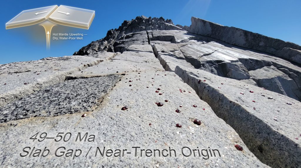
A slab gap, also referred to as a slab window, is a break or opening that develops in a subducting oceanic plate when a mid-ocean spreading ridge is consumed at a convergent margin. The sequence of events unfolds as follows:
- An active spreading ridge in the Pacific Ocean continuously generates two diverging oceanic plate segments moving away from each other
- As the North American continent overrides the ridge, both plate segments begin subducting in opposite directions beneath the continent
- Because the two segments are diverging rather than cohering, a gap, or window, opens between them in the subsurface
- Hot asthenospheric mantle material wells upward through this opening, rising toward the base of the crust without passing through a zone of hydrated oceanic rock
- This mantle-derived heat generates magma that carries almost none of the water-enriched chemistry associated with standard subduction
- The resulting magma is dry, water-poor, and geochemically distinctive, producing fine-grained, hornblende-absent, peraluminous granite exactly like the Pilchuck Stock
How the Model Aligns With Field Observations
The slab gap hypothesis does not require special pleading or selective evidence. Every major anomaly observed in the Pilchuck granite aligns with predictions from the model:
| Geological Feature | Subduction-Arc Expectation | Slab Gap Prediction | Mount Pilchuck Observation |
|---|---|---|---|
| Mineral texture | Coarse, salt-and-pepper | Fine-grained | Fine-grained ✓ |
| Hornblende presence | Abundant | Absent or rare | Absent ✓ |
| Biotite presence | Common | Rare | Rare ✓ |
| Garnet occurrence | Uncommon | Possible | Present ✓ |
| Water content of melt | High | Low | Low, peraluminous ✓ |
| Age relative to arc | Synchronous with arc | Predates arc | ~50 Ma, predates arc ✓ |
| Surface volcanic equivalent | Present | Absent or obscure | None confirmed ✓ |
The structural position of the Pilchuck Stock adds further weight to this interpretation. The granite intrudes through the Western Melange Belt, a package of older, exotic accreted terranes assembled from far-travelled oceanic fragments. This places the pluton at a tectonic boundary between indigenous North American crust and material that originated elsewhere in the ancient Pacific, precisely where near-trench magmatism would be expected to occur.
The Pilchuck Stock is notable not just for what it contains, but for what it lacks. The combination of a dry melt signature, a pre-arc crystallisation age, peraluminous chemistry, garnet occurrence, and intrusion through exotic accreted terranes represents a convergence of evidence that is difficult to explain through any mechanism other than mantle upwelling through a slab window.
Reading the Rock Underfoot: Joints, Slabs, and Trail Gaps
Why the Trail Surface Looks the Way It Does
Hikers ascending the upper sections of the Mount Pilchuck trail encounter large, flat granite slabs separated by striking gaps and fractures. These physical gaps are frequently misidentified as evidence of volcanic activity or active faulting. They are neither. They are exfoliation joints, and their origin story is entirely different.
Joints in granite form through three principal mechanisms:
- Thermal contraction: as molten magma cools from a liquid state, it contracts volumetrically, generating internal stress that fractures the rock in systematic patterns
- Pressure release jointing: the Pilchuck Stock crystallised at an estimated depth of at least 5 kilometres beneath the surface. Over tens of millions of years, erosion removed the overlying rock, gradually reducing confining pressure. The granite responded by expanding slightly outward, fracturing in sheets roughly parallel to the surface, a process called exfoliation
- Tectonic stress: regional faulting and stress fields impose additional fracture sets on the pluton
The result is the characteristic stepped, slabby terrain that defines the upper trail. The yellow trail markers applied approximately in the 1960s guided hikers along the original route across these joint-controlled surfaces. Significant trail relocation and reconstruction work carried out in the late 1980s and early 1990s by both Forest Service crews and contract teams navigated these same geological structures.
Common Misconception: The dramatic gaps between granite slabs on the Mount Pilchuck trail are not volcanic features, not faults, and not evidence of ongoing geological instability. They are the predictable result of a pluton that spent tens of millions of years being slowly unroofed by erosion, releasing the pressure that once confined it at depth, and fracturing in response. In this sense, they offer some of the most accessible surface clues to geology visible on any trail in the Pacific Northwest.
How Ice Sculpted the Summit Landscape
Alpine Glaciation on the Pilchuck Stock
During peak Pleistocene glaciation, alpine ice accumulated at the summit of Mount Pilchuck and descended multiple faces of the mountain. The granite surface bears a clear record of this glacial activity in several landform types:
- Glacially polished slabs: smooth surfaces where flowing ice abraded the granite, sometimes preserving visible striations indicating ice movement direction
- Plucking scars: irregular depressions where glacial ice quarried joint-bounded blocks directly from the surface
- Arêtes: knife-edged ridges formed where glaciers eroded both flanks of a ridge simultaneously; a prominent example wraps around the upper mountain toward the summit
- Cirques: bowl-shaped depressions carved at glacier heads; Heather Lake and Lake 22 occupy cirque basins on Pilchuck's flanks, both representing significant topographic depressions carved by concentrated glacial erosion
- Roche moutonnées: asymmetric rock knobs smoothed on the up-ice side and irregularly plucked on the down-ice side, visible along the upper slope skyline
The Cirque Floor Method: Quantifying Past Climate
One of the more elegant applications of cirque mapping involves using cirque floor elevations as proxies for past climate conditions. The floor of a cirque approximates the Pleistocene equilibrium line altitude (ELA), the elevation at which annual snow accumulation balanced melting during the glacial maximum.
By comparing past ELA to the position of modern glaciers, researchers can apply atmospheric lapse rates to estimate temperature differences. If modern glaciers sit approximately 3,000 feet above a cirque floor elevation, the implied temperature depression during the glacial maximum approaches roughly 15 degrees Celsius colder than present conditions. This transforms passive landscape observation into quantitative palaeoclimate data of genuine scientific value.
Continental Ice: A Separate and Asynchronous Story
Simultaneously, though critically not synchronously, with alpine glaciation on Pilchuck itself, the Cordilleran Ice Sheet's Puget Lobe advanced southward through the Puget Lowland. At maximum extent, the Puget Lobe reached an estimated thickness of approximately one mile, roughly 5,000 feet, over the central lowland, tapering to approximately 3,000 to 3,800 feet near the Cascade front.
Evidence for continental ice reaching Mount Pilchuck specifically comes from glacial till deposits preserved at approximately 3,800 feet elevation on the mountain's slopes. Mount Pilchuck likely functioned as a nunatak, an isolated peak projecting above the surrounding ice sheet, with continental ice wrapping around at least three of its sides.
Perhaps the most counterintuitive insight from Pilchuck's glacial record is that the alpine glaciers on the mountain and the advancing Puget Lobe did not reach their maximum extents at the same time. Regional research indicates that Cascade alpine glaciers lagged the continental ice sheet by several thousand years during the most recent Late Pleistocene glaciation. When the Puget Lobe was at its maximum advance, local alpine glaciers may have been comparatively small or already retreating.
This apparent contradiction reflects fundamentally different moisture and temperature regimes driving each ice system. The Cordilleran Ice Sheet was nourished by precipitation patterns originating far to the north in Canada; local alpine glaciers responded to more immediate regional climate signals at lower latitudes. Moreover, the broader influence of supercontinent cycles on long-term tectonic and climatic patterns provides useful context for understanding why such regional variations in glacial timing can occur.
An additional complexity arises when examining the deep U-shaped valleys of the western Cascades, including the Middle Fork Snoqualmie, Skykomish River, and West Fork Foss drainages. These valleys display classic glacial morphology that appears to require larger ice volumes than either the most recent alpine glaciers or the Puget Lobe can fully account for in isolation. The most plausible explanation is that larger alpine glaciers during earlier glacial cycles, predating the most recent advance, performed the bulk of the valley-carving work. The most recent ice systems inherited and modified a landscape already shaped by older, more extensive glaciation.
Mount Pilchuck in Regional Context
Comparative Overview of North Cascades Granites
| Pluton | Approximate Age | Texture | Likely Origin | Notable Minerals |
|---|---|---|---|---|
| Pilchuck Stock | ~49 to 50 Ma | Fine-grained | Slab gap, near-trench | Garnet, no hornblende |
| Mount Stuart Batholith | ~90 to 96 Ma | Coarse, salt-and-pepper | Subduction arc | Hornblende, biotite |
| Black Peak Batholith | ~90 Ma | Coarse | Subduction arc | Hornblende, biotite |
| Golden Horn Batholith | ~48 Ma | Coarse | Eocene arc or extension | Hornblende |
| Tatoosh Pluton | ~14 to 19 Ma | Medium to coarse | Cascade arc | Hornblende, biotite |
| Cloudy Pass Batholith | ~35 Ma | Medium | Subduction arc | Hornblende, biotite |
The Pilchuck Stock stands apart from every entry in this table. Most Cascade plutons can be traced spatially and temporally to volcanic centres. The Pilchuck Stock has no confirmed surface volcanic equivalent. Its position intruding through exotic accreted terranes of the Western Melange Belt places it at a tectonic boundary that most arc granites never intersect. The combination of age, chemistry, mineralogy, structural position, and the absence of a volcanic counterpart makes it one of the most geochemically distinctive granites on the West Coast of North America. Furthermore, the broader regional setting, including the geology of the Chumstick Basin, provides additional context for understanding the complex Eocene tectonics shaping this part of the Pacific Northwest. As field geologists who have studied the area have noted, only a handful of people are broadly aware of what makes this rock unusual; most visitors simply see granite.
The next major ASX story will hit our subscribers first
Frequently Asked Questions: Mount Pilchuck Geology
What type of rock makes up Mount Pilchuck?
Mount Pilchuck is composed of granite and granodiorite belonging to the Pilchuck Stock, an intrusive igneous body that crystallised from magma approximately 49 to 50 million years ago at a depth of at least 5 kilometres. The upper several thousand feet of the mountain consists of a single coherent block of this material, with the granite intruding into the older Western Melange Belt at lower elevations.
What exactly is near-trench magma?
Near-trench magmatism refers to igneous activity occurring unusually close to a subduction zone trench, typically because a spreading ridge has been subducted, creating a slab gap. Mantle material rises through this gap with minimal interaction with hydrated oceanic rock, producing dry, water-poor magma with chemistry distinctly different from arc granites. The Pilchuck Stock's fine grain size, absent hornblende, peraluminous classification, and pre-arc age all align with this mechanism, making it a textbook example of Mount Pilchuck granite slab gap magmatism.
Are the gaps between slabs on the trail dangerous or geologically active?
No. The gaps are exfoliation joints produced by cooling contraction and pressure release as overlying rock eroded away over geological time. They are structurally stable features of the pluton, not evidence of active faulting or volcanic processes.
Why does Pilchuck granite lack dark minerals common in other Cascades granites?
The absence of hornblende and scarcity of biotite directly reflect a water-poor magma source. Standard subduction-driven granites crystallise hornblende and biotite because water from the descending plate is available during crystallisation. The slab gap mechanism bypasses this water source entirely, generating dry melts that produce lighter, more felsic granite with a fundamentally different mineral assemblage.
What glacial features can hikers identify on the trail?
Hikers can observe glacially polished granite slabs, plucking scars, arêtes along the upper ridgeline, and cirque basins on the flanks including those occupied by Heather Lake and Lake 22. Continental glacial till has also been identified at elevations up to approximately 3,800 feet on the mountain's slopes, providing direct evidence of Puget Lobe ice reaching this elevation.
Key Takeaways for the Geologically Curious Hiker
- The Pilchuck Stock is a rare near-trench, slab-gap granite, one of a limited number documented along the entire West Coast of North America, making it scientifically significant well beyond its regional setting
- Every geological anomaly in the rock, from absent hornblende to peraluminous chemistry to garnet occurrence to pre-arc age, points consistently toward mantle upwelling through a slab window rather than conventional subduction
- The visible slab gaps on the trail are exfoliation joints produced by deep-crustal cooling and pressure release over tens of millions of years, not volcanic or fault features
- Mount Pilchuck preserves evidence of two distinct glacial systems, alpine and continental, that operated asynchronously, encoding a layered and sometimes counterintuitive archive of Pleistocene climate history
- The deep U-shaped valleys flanking the Cascades may record the work of older, larger alpine glaciers from earlier glacial cycles, with the most recent ice systems operating at reduced scale compared to their predecessors
Disclaimer: Geological interpretations presented in this article reflect current scientific hypotheses based on available field evidence. Some elements of the slab gap model for the Pilchuck Stock remain areas of active research. Readers with specific research interests are encouraged to consult primary geological literature for the most current findings. Additionally, those wishing to explore the trail itself can find detailed route information through the Washington Trails Association.
Want to Discover What Lies Beneath the Next Major Find?
Just as the Pilchuck Stock's unusual mineralogy signals something extraordinary happening beneath the surface, significant ASX mineral discoveries often reward those who recognise the signs early — Discovery Alert's proprietary Discovery IQ model scans daily ASX announcements in real time, instantly translating complex geological data across 30+ commodities into actionable insights for investors at every level. Explore historic discoveries and their remarkable returns, then begin your 14-day free trial to position yourself ahead of the broader market.