May 20, 2026
Understanding Multi-Hazard Assessment Frameworks
Modern mining operations face increasingly complex geotechnical challenges that demand sophisticated assessment methodologies. The integration of multiple hazard evaluation systems has emerged as a critical requirement for maintaining operational safety and maximising resource extraction efficiency. Contemporary geotechnical risk management in mining requires systematic evaluation across four distinct data domains: geochemical analysis for material degradation patterns, geological-structural mapping for fault identification, geophysical surveys for subsurface property quantification, and comprehensive geotechnical synthesis for holistic risk assessment.
Ground stability monitoring protocols have evolved beyond traditional visual inspection methods to encompass real-time sensor networks capable of detecting millimetre-scale slope movements. These advanced monitoring systems integrate accelerometers, inclinometers, and GPS-based displacement sensors to provide continuous assessment of ground behaviour patterns. Furthermore, water infiltration risk evaluation has similarly advanced through implementation of automated drainage system optimisation protocols that respond dynamically to changing hydrogeological conditions.
The technical architecture supporting effective multi-hazard assessment requires integration of previously disconnected analytical domains. Seismic activity assessment now incorporates vibration impact modelling that accounts for both natural earthquake activity and mining-induced seismicity. This comprehensive approach enables prediction of cumulative stress effects on rock mass stability, supporting proactive adjustment of operational parameters before critical thresholds are exceeded.
Integrated Data Collection Methodologies
Real-time sensor networks represent a fundamental advancement in geotechnical monitoring capability. Modern installations can detect slope movement at sub-millimetre accuracy levels, enabling identification of developing instability conditions weeks or months before visible surface manifestations occur. The integration of geophysical survey data with geological mapping provides quantitative validation of conceptual geological models, reducing interpretation uncertainty that historically compromised risk assessment reliability.
Hydrogeological monitoring systems now incorporate automated groundwater pressure measurement networks that trigger alerts when pore pressure ratios approach critical stability thresholds. These systems prove particularly valuable in identifying seasonal or weather-related changes in ground stability conditions. Moreover, geochemical analysis protocols have expanded to include real-time monitoring of oxidation processes and mineral dissolution patterns that affect long-term slope stability through progressive rock mass weakening.
The convergence of these monitoring methodologies creates comprehensive hazard identification capability that exceeds the sum of individual components. Integrated data collection enables correlation analysis between different hazard indicators, supporting development of predictive models that account for complex interactions between geological, hydrological, and geochemical processes affecting slope stability.
When big ASX news breaks, our subscribers know first
Traditional Workflow Limitations in Contemporary Mining Operations
The persistence of manual interpretation methodologies in modern mining operations creates systematic constraints that undermine effective geotechnical risk management in mining. Annual model update cycles, which remain common across the industry, mean that risk assessments progressively deteriorate in accuracy throughout the year as new field observations accumulate without integration into existing geological models. This temporal lag between data collection and risk assessment updates creates operational blind spots that can mask developing hazardous conditions.
Data fragmentation across multiple disconnected software platforms represents another critical limitation of traditional approaches. When geological mapping software, geotechnical analysis tools, and mine planning systems operate independently, technical teams must manually transfer information between platforms, creating multiple opportunities for transcription errors and version inconsistencies. Consequently, the resulting information silos prevent holistic risk evaluation that requires synthesis of data across multiple analytical domains.
Cost Implications of Reactive Risk Management
The financial consequences of reactive geotechnical management extend far beyond direct remediation expenses following slope failures or equipment damage. Production losses from unplanned operational disruptions can exceed immediate repair costs by factors of 10 to 50, depending on the scale of mining operations affected. Environmental remediation expenses following geotechnical incidents often require years of monitoring and active management, creating long-term financial obligations that compound initial loss estimates.
Regulatory compliance costs associated with geotechnical incidents include potential operational shutdowns, enhanced monitoring requirements, and elevated bonding obligations. Insurance premium increases frequently follow significant geotechnical events, reflecting actuarial reassessment of operational risk profiles. These indirect costs often exceed direct incident costs by substantial margins, emphasising the economic importance of proactive risk management approaches.
The opportunity cost of conservative operational approaches represents an often-overlooked financial impact of inadequate geotechnical risk assessment. When geological uncertainty forces establishment of oversized exclusion zones or reduced operational rates, the foregone resource recovery value can represent millions of dollars in lost revenue over mine life. However, improved risk assessment capability enables more precise delineation of safe operational boundaries, directly translating to enhanced resource recovery opportunities.
Dynamic Visualisation Capabilities Transform Geological Understanding
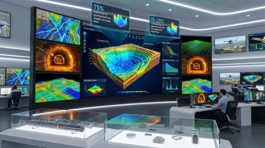
Three-dimensional modelling technology fundamentally alters how mining professionals conceptualise and analyse subsurface geological conditions. Real-time 3D geological modeling updates incorporating new field data enable continuous refinement of geological understanding rather than periodic major revisions. Implementation of advanced modelling approaches has demonstrated quantifiable efficiency improvements, with some operations achieving 75% reductions in model update timeframes through elimination of manual wireframe construction processes.
Implicit modelling techniques represent a significant technical advancement over traditional interpretation methodologies. These algorithmic approaches generate smooth, continuous geological surfaces from scattered data points without requiring manual surface construction. The reduction in human interpretation steps eliminates subjective bias while enabling rapid model revision when new geological information becomes available. For instance, operations implementing implicit modelling report substantial improvements in interpretation consistency across different technical staff members.
Cross-sectional analysis capabilities within 3D modelling environments enable structural understanding that exceeds traditional 2D interpretation approaches. Three-dimensional models can generate cross-sections at any location and orientation, permitting detailed analysis of structural relationships in multiple directions simultaneously. This capability proves particularly valuable for understanding fault geometries, discontinuity patterns, and their interactions with mining-induced stress fields.
Predictive Modelling Applications
Contemporary 3D modelling platforms enable scenario analysis that was economically prohibitive under traditional interpretation workflows. Technical teams can rapidly evaluate alternative geological interpretations and assess their implications for slope stability under different operational scenarios. This capability supports informed decision-making regarding operational trade-offs between resource recovery objectives and safety requirements.
Integration of 3D geological models with numerical analysis software enables quantitative slope stability assessment through finite element or distinct element analysis. These computational approaches provide quantitative factor of safety calculations that exceed qualitative interpretation reliability. Furthermore, the combination of detailed 3D geological models with rigorous numerical analysis creates unprecedented capability for evidence-based risk assessment and operational planning.
The following table illustrates measured improvements from 3D modelling implementation:
| Performance Metric | Traditional Approach | 3D Modelling Implementation | Improvement Factor |
|---|---|---|---|
| Model Update Frequency | Annual revisions | Quarterly or event-driven | 4x more responsive |
| Interpretation Time | Manual wireframe construction | Automated implicit modelling | 75% time reduction |
| Data Integration | Multiple disconnected platforms | Unified modelling environment | 100% data accessibility |
| Risk Assessment Currency | Up to 12 months outdated | Real-time integration | 85% improvement in timeliness |
Cloud-Based Collaboration Enhances Decision-Making Speed
Cloud-enabled project management platforms fundamentally transform how geotechnical information flows through mining organisations. Version-controlled model sharing across global mining operations eliminates the technical barriers that previously prevented rapid expertise sharing between different operational sites. Cloud-based collaboration enables specialists at one location to provide real-time technical support for geotechnical challenges at remote operations, effectively multiplying available technical expertise across mining organisations.
Centralised data architecture through cloud platforms eliminates the version confusion that characterises traditional file-sharing approaches. When multiple technical staff members work simultaneously on geological interpretations, cloud-based version control ensures that all team members operate from identical data sets and model versions. This systematic approach to information management reduces interpretation inconsistencies while creating comprehensive audit trails for regulatory compliance documentation.
Enhanced Decision-Making Processes
Real-time stakeholder communication during critical geotechnical events enables rapid mobilisation of technical expertise and operational response capability. Cloud-based platforms can automatically distribute alerts when monitoring thresholds are exceeded, ensuring that appropriate personnel receive immediate notification regardless of their physical location. This capability proves particularly valuable for operations in remote locations where rapid expert response is logistically challenging.
Standardised reporting templates integrated with cloud-based data management ensure consistent risk evaluation methodologies across different operational sites. In addition, automated alert systems can trigger when geotechnical parameters exceed predetermined thresholds, providing early warning capability that enables proactive operational adjustments rather than reactive crisis management.
Mobile accessibility for field teams represents a critical operational advantage of cloud-based systems. Geologists and geotechnical engineers can access current model interpretations and risk assessments directly from field locations using tablet computers or mobile devices. This capability enables field observations to be immediately contextualised within current geological understanding, supporting more informed decision-making during drilling programs or operational planning activities.
Quantifying Return on Investment for Digital Geotechnical Systems
Mining operations implementing integrated digital geotechnical risk management systems report measurable improvements across multiple operational metrics. Model update efficiency improvements typically range from 60% to 80% reduction in time requirements for geological model revisions. These efficiency gains translate directly to increased responsiveness in risk assessment capability and reduced labour costs for technical modelling activities.
Resource recovery enhancements represent the most significant financial benefit of improved geotechnical risk management in mining. Operations with enhanced geological understanding can more precisely delineate safe operational boundaries, reducing the size of geotechnical exclusion zones that constrain resource extraction. Some implementations have achieved 120% to 140% increases in projected medium-term resource recovery through better definition of operationally accessible reserves.
Operational Efficiency Metrics
The quantification of operational improvements provides concrete evidence of digital system value. Enhanced geological understanding enables optimisation of exclusion zone boundaries, reducing geotechnical constraint areas that previously prevented resource extraction. Environmental risk mitigation through improved slope failure prediction decreases the probability of incidents exceeding licensed operational boundaries, reducing regulatory compliance risks and associated financial exposure.
Cost avoidance represents a substantial but often undervalued benefit category. Proactive identification of developing geotechnical hazards enables preventive interventions that cost significantly less than reactive remediation following slope failures or equipment damage. The financial value of avoided incidents often exceeds system implementation costs within the first operational year.
Industry Analysis: Mining operations implementing comprehensive digital geotechnical risk management report average cost savings of 15% to 25% in operational risk management expenses within two years of system deployment, primarily through reduced incident frequency and enhanced operational efficiency.
Safety and Compliance Benefits
Enhanced safety performance through predictive hazard identification creates measurable improvements in operational risk profiles. Systematic monitoring protocols reduce accident probability through early identification of developing unstable conditions. This proactive approach to safety management enhances regulatory compliance while improving stakeholder confidence in operational safety standards.
Insurance premium reductions frequently accompany implementation of systematic geotechnical risk management protocols. Insurance providers recognise that proactive monitoring and predictive analysis substantially reduce claim probability, translating to reduced premium obligations that partially offset system implementation costs. The cumulative financial benefit of reduced insurance expenses can approach 10% to 15% of annual premium costs.
Critical Implementation Strategies for Successful Digitisation
Successful implementation of digital geotechnical risk management systems requires systematic evaluation of technology compatibility with existing mining software ecosystems. Legacy mine planning software, operational control systems, and existing geological databases must integrate seamlessly with new geotechnical platforms to avoid creating additional data silos. Compatibility assessment should evaluate both technical integration requirements and workflow disruption potential during system deployment.
Scalability evaluation proves critical for mining companies operating multiple sites with varying geological complexities and operational scales. Technology platforms that function effectively at smaller operations may lack the computational capacity or data management capability required for large-scale mining operations. Multi-site deployment requirements should inform initial platform selection to ensure consistent capability across all operational locations.
Phased Deployment Approach
Systematic implementation through phased deployment minimises operational disruption while enabling continuous improvement based on operational experience. The following sequence has proven effective across multiple mining operations:
- Pilot Program Implementation: Single-site deployment with comprehensive performance monitoring and user feedback collection
- Historical Data Migration: Systematic digitisation and validation of existing geological and geotechnical databases
- Technical Staff Certification: Comprehensive training programmes ensuring staff competency with new analytical tools
- System Integration: Connection with existing mine planning and enterprise resource planning systems
- Performance Monitoring: Key performance indicator tracking and continuous improvement protocol implementation
User training requirements represent a critical success factor that deserves substantial resource allocation. Technical staff must develop competency not only with specific software platforms but also with new analytical workflows that differ substantially from traditional manual interpretation approaches. Furthermore, change management considerations should address potential resistance to workflow modifications while emphasising the professional development opportunities created by advanced analytical capability.
The next major ASX story will hit our subscribers first
Regulatory Standards Drive Technology Adoption Requirements
Global mining jurisdictions increasingly mandate systematic geotechnical risk management in mining approaches that exceed traditional visual inspection and periodic assessment methodologies. Western Australian geotechnical standards require comprehensive slope stability assessment based on quantitative analysis rather than qualitative engineering judgment alone. These regulatory requirements effectively mandate implementation of analytical tools capable of producing defensible quantitative risk assessments.
Canadian mining regulations emphasise ground control management plans that demonstrate systematic monitoring and predictive capability. European Union environmental directives affecting mining operations require evidence-based assessment of environmental risks associated with slope failures or ground subsidence. International safety standards for underground excavation increasingly specify continuous monitoring requirements that necessitate automated sensor networks and data analysis capability.
Documentation and Reporting Standards
Systematic risk register maintenance with comprehensive audit trails represents a universal regulatory requirement across major mining jurisdictions. Digital platforms enable automated documentation of risk assessment processes, creating defensible evidence of due diligence in safety management. However, quantitative risk assessment methodologies using probabilistic modelling provide regulatory authorities with objective evidence of hazard evaluation rather than subjective professional opinion alone.
Emergency response protocols integrated with automated monitoring systems enable rapid notification of relevant authorities when geotechnical conditions exceed established safety thresholds. Stakeholder communication frameworks for incident management benefit substantially from systematic information management that ensures accurate, timely communication during crisis situations.
Emerging Technologies Shape Future Risk Management Capability
Artificial intelligence and machine learning applications represent the next frontier in geotechnical risk assessment technology. Predictive analytics algorithms can identify patterns in monitoring data that exceed human pattern recognition capability, providing early warning of developing instability conditions weeks before conventional analysis would detect concerning trends. AI-driven sensor integration enables automated anomaly detection that supplements human interpretation with computational analysis of subtle data relationships.
Machine learning optimisation of monitoring sensor placement maximises information value while minimising infrastructure costs. Algorithms can analyse historical data to identify optimal sensor locations that provide maximum hazard detection capability with minimum redundancy. This optimisation approach enables more cost-effective monitoring network design while enhancing overall system performance.
Advanced Monitoring Technologies
Drone-based photogrammetry enables high-resolution slope mapping at frequencies impossible with traditional survey methods. Weekly or monthly drone flights can detect surface changes at millimetre accuracy levels, providing early indication of developing slope instability. Satellite interferometry for large-scale ground movement detection complements ground-based monitoring with regional-scale deformation mapping capability.
Fiber optic sensing networks enable distributed strain monitoring along critical infrastructure or slope faces. These systems can detect deformation along kilometres of monitoring lines with spatial resolution measured in metres and strain sensitivity at micro-strain levels. Internet of Things sensor integration creates comprehensive environmental monitoring capability that correlates geotechnical conditions with weather patterns, groundwater levels, and operational activities.
Strategic Framework Development for Comprehensive Risk Management
Mining companies developing comprehensive geotechnical risk management strategies must align risk appetite definitions with corporate safety objectives while maintaining operational efficiency. Technology roadmap development requires systematic capability building that progresses from basic data integration through advanced predictive analytics. Cross-functional team establishment should include representatives from geology, geotechnical engineering, mine planning, operations, and environmental management to ensure holistic perspective development.
Continuous improvement protocols based on operational feedback enable systematic refinement of risk assessment methodologies. Regular strategy review and adaptation ensure that technological advances are incorporated systematically rather than through ad hoc technology adoption. Performance measurement systems should incorporate both leading indicators for proactive risk identification and lagging indicators for incident analysis and prevention.
Performance Measurement Systems
Leading indicators for proactive risk identification include monitoring system performance metrics, model update frequency, and risk assessment currency measurements. Lagging indicators for incident analysis include safety performance trends, environmental compliance metrics, and operational efficiency improvements. In addition, benchmarking against industry best practices provides context for performance evaluation while identifying opportunities for further improvement.
The integration of geotechnical risk management with broader operational optimisation creates synergistic benefits that exceed individual system capabilities. When geological understanding directly informs mine planning optimisation, operational efficiency improvements can justify system implementation costs through enhanced resource recovery alone, with safety and compliance benefits representing additional value creation.
Modern mining operations require sophisticated approaches that leverage data-driven operations for enhanced safety, operational efficiency, and environmental compliance. The transition from traditional manual methodologies to integrated digital systems represents both a technological upgrade and a fundamental shift in professional practice toward evidence-based decision-making supported by comprehensive data analysis. Furthermore, this evolution aligns with broader mining innovation trends and supports the industry's sustainability transformation through predictive modelling capability.
Ready to Capitalise on Mining Technology Advancements?
Discovery Alert's proprietary Discovery IQ model delivers real-time alerts on significant mining and exploration discoveries, instantly empowering subscribers to identify actionable opportunities ahead of the broader market. Begin your 30-day free trial today and secure your market-leading advantage whilst technological innovations reshape the mining landscape.