July 6, 2026
The Invisible Geologist: How Light From 12 Miles Up Is Reshaping America's Mineral Future
Mineral discovery has always been a game of incomplete information. For most of exploration history, geologists worked with what they could see, sample, and drill. The problem is that the most significant ore systems are rarely announced by obvious surface clues. They hide beneath thin layers of alluvial cover, beneath weathering rinds, beneath the ordinary-looking volcanic rocks that dot the American West in their millions. The gap between what lies beneath and what a geologist can observe on foot has been one of the fundamental constraints on domestic mineral resource development for over a century.
That constraint is now being dismantled from above.
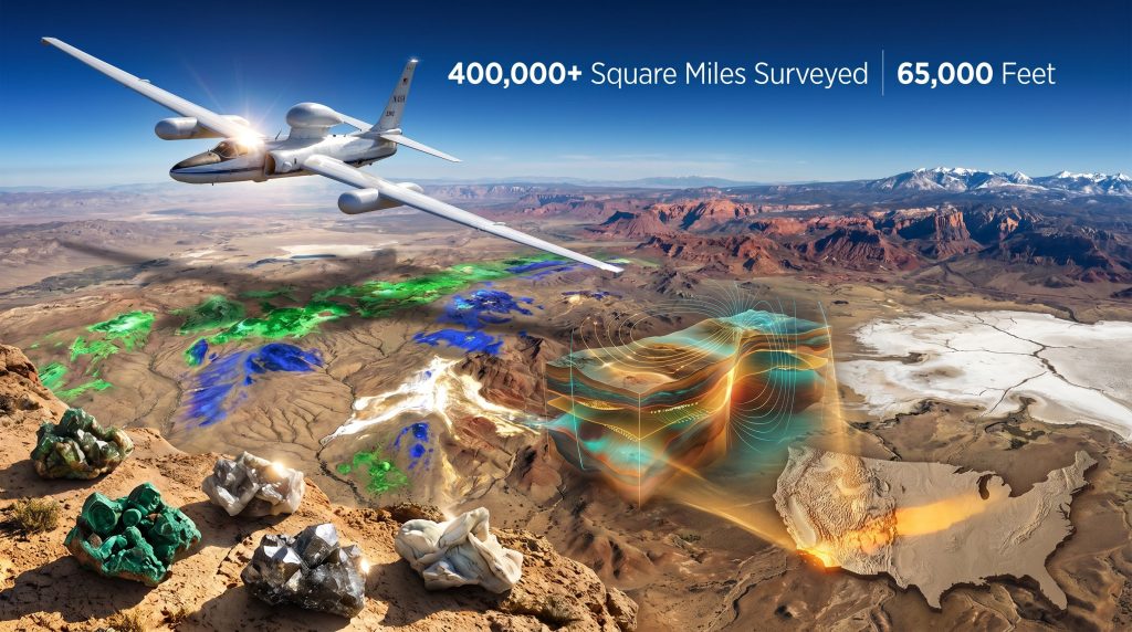
NASA hyperspectral mineral mapping of the American West, conducted under a joint USGS-NASA initiative known as GEMx, is producing a new class of geological intelligence that was simply not available to previous generations of exploration scientists. By capturing reflected and emitted light across more than 200 discrete spectral bands from a research aircraft cruising near the edge of Earth's atmosphere, the programme is building what will ultimately become the most comprehensive surface mineral map ever constructed for any region on Earth.
Understanding why this matters requires stepping back from the immediate news cycle and examining the structural dynamics that make this kind of data so strategically significant right now.
When big ASX news breaks, our subscribers know first
Why the American West Is the Right Place to Start
The western United States represents one of the most mineralogically diverse and economically significant geological terrains on the planet. The region encompasses ancient Precambrian basement rocks, Mesozoic magmatic arcs, Cenozoic volcanic fields, and extensional basin systems. This variety of geological environments translates directly into variety of mineral deposit types, from porphyry copper systems in Arizona and Nevada, to lithium-bearing brine basins in the Great Basin, to rare earth-bearing carbonatites across the Mountain West.
Despite more than a century of intensive prospecting and exploration, significant portions of this terrain remain incompletely characterised at the surface, let alone at depth. Legacy geological maps in some areas date back decades, compiled before the advent of modern remote sensing and geochemical techniques. Entire mountain ranges contain unexplored structural corridors that have never been systematically sampled.
The USGS Earth Mapping Resources Initiative, known as Earth MRI, was established precisely to address this data deficit. Its mandate is systematic, not opportunistic: to build a rigorous, multi-layer geoscience dataset across the entire country that can identify domestic critical minerals demand and reduce U.S. dependence on foreign sources of materials essential to modern technology, energy systems, and national defence.
GEMx, the Geological Earth Mapping Experiment, represents the hyperspectral data collection component of Earth MRI, and by current measure, the most technically sophisticated layer of the programme.
The Physics Behind Mineral Detection From 65,000 Feet
Every mineral has a fingerprint. When electromagnetic radiation strikes a mineral surface, some wavelengths are absorbed, some are reflected, and the precise pattern of absorption and reflection is determined by the mineral's crystal structure and chemical composition. No two mineral species share an identical spectral signature, which means that a sensor capable of measuring reflected light across a sufficiently fine grid of wavelengths can, in principle, identify minerals remotely without physical contact.
This is the core principle behind hyperspectral imaging, and it is not new science. What has changed dramatically is the quality and resolution of the sensors, the altitude at which they can operate effectively, and the computational power available to process the resulting datasets.
The NASA ER-2 aircraft, a civilian variant of the U-2 reconnaissance platform, carries hyperspectral imaging systems to an operational altitude of 65,000 feet, approximately 12 miles above the surface. At that altitude, the aircraft is above more than 90% of Earth's atmosphere, which minimises atmospheric interference with the spectral signal and enables the sensors to capture surface mineralogy with exceptional fidelity.
Two primary sensor systems are deployed:
| Sensor | Spectral Domain | Key Detection Targets |
|---|---|---|
| AVIRIS-5 | Visible to Shortwave Infrared (VSWIR) | Clay minerals, micas, carbonates, iron oxides |
| HyTES | Longwave Infrared (LWIR) | Silicates, host rock lithologies not detectable by VSWIR sensors |
The combination of VSWIR and LWIR coverage is particularly significant. Previous hyperspectral surveys relied primarily on VSWIR sensors, which are highly effective at identifying hydrothermal alteration products but less effective at characterising the underlying host rock lithologies. By adding LWIR coverage through HyTES, the GEMx programme captures a more complete picture of the geological environment hosting potential mineral deposits.
AVIRIS-5 achieves a spatial resolution of approximately 8 metres, a substantial improvement over the 15 to 90 metre resolution of satellite-based systems such as ASTER. For mineral exploration purposes, this difference is material: at 8-metre resolution, individual alteration patches of outcrop scale can be resolved and characterised, whereas at 30 or 90 metres, these same features are averaged out and may become invisible.
Why Arid Terrain Amplifies the Technology's Effectiveness
Hyperspectral mineral identification depends on the sensor being able to see the surface. In heavily vegetated landscapes, the dominant spectral signal is from plant material, not from minerals, and mineral signatures are suppressed or masked entirely. The American West, characterised by semi-arid to arid climates across much of its extent, presents ideal conditions for hyperspectral mapping.
Sparse vegetation cover means that mineral surfaces are directly exposed to the sensor, maximising detection accuracy and reducing ambiguity in spectral interpretation. This is not a coincidence in the programme design. The systematic targeting of the American West for the initial GEMx campaign reflects a deliberate optimisation: extract maximum geological signal from a terrain that is simultaneously mineralogically prospective and spectrally accessible.
From Spectral Anomaly to Drill Target: The Exploration Logic
The practical value of hyperspectral data in mineral exploration operates through a specific interpretive logic that is worth unpacking, because it illuminates both the power and the limitations of the technology.
Hydrothermal ore systems, which include porphyry copper deposits, epithermal gold-silver systems, and many REE occurrences, form when hot mineralised fluids move through rock. As these fluids cool and react with the host rock, they create characteristic alteration halos around the mineralised core. These alteration zones contain distinctive mineral assemblages: in porphyry copper systems, for example, the outer propylitic zone contains chlorite and epidote, the intermediate argillic zone contains clay minerals like kaolinite and illite, and the innermost potassic zone contains feldspar and biotite. Each of these mineral assemblages carries a distinct spectral signature detectable by AVIRIS-5.
What the hyperspectral sensor captures, therefore, is not the ore itself. It captures the footprint of the hydrothermal system that produced the ore. This distinction matters enormously for understanding both the discovery potential and the discovery risk of the technology:
- Detection is of alteration, not mineralisation directly. A strong spectral anomaly indicates a hydrothermal system existed. It does not confirm economic grades of ore are present at depth.
- Alteration assemblage discrimination enables deposit type classification. The specific combination of clay minerals detected can help distinguish porphyry from epithermal from skarn systems before a single drill hole is turned.
- Spatial extent of alteration is directly mappable. Hyperspectral data can delineate the full areal footprint of an alteration system, which is a key input to volume and resource estimation models at the earliest stage of exploration.
- False positives exist but are characterisable. Not every spectral anomaly reflects an economic mineral system, but the mineralogical information itself is real and provides context for follow-up decisions.
The practical demonstration of this logic emerged during the April 2026 survey flights over Colorado, when USGS geologist Erik Tharalson identified a spectral anomaly in a large volcanic rock outcrop. The detected mineral assemblage was consistent with alteration patterns associated with a porphyry copper system. As Tharalson noted, the outcrop appeared unremarkable to conventional field observation, reinforcing the core argument for hyperspectral surveying: that the most important geological features in under-explored terrain are frequently the ones that cannot be seen by the naked eye.
The Scale of What Has Already Been Accomplished
The GEMx survey is not a pilot programme. It is already, by multiple accounts, the world's largest airborne hyperspectral survey ever conducted, and its current coverage statistics merit careful attention.
| Programme Metric | Current Status |
|---|---|
| Total area surveyed | More than 400,000 square miles |
| Equivalent land area | Approximately the size of Spain |
| Survey commencement | September 2023 |
| Total flight hours (to 2025) | More than 200 hours |
| Primary aircraft | NASA ER-2 (high-altitude research aircraft) |
| States with substantial coverage | California (fully mapped), Nevada, Arizona, Oregon |
| 2026 expansion target | Rocky Mountain corridor (Colorado Springs base, April 1 to May 20, 2026) |
| Remaining priority states | Utah, Wyoming, Idaho, New Mexico |
California's completion represents a significant milestone. The state encompasses some of the most geologically diverse terrain in North America, including the Sierra Nevada batholith, the Basin and Range province's western margin, the Klamath Mountains, and the Coast Ranges. A complete hyperspectral map of California provides an immediate analytical baseline for exploration targeting across a jurisdiction that has historically been among the most productive in the western U.S.
The expansion into Colorado in 2026 targets geology of an entirely different character. The Rocky Mountain corridor exposes Precambrian basement rocks alongside Laramide-age intrusive systems that are precisely the geological environments associated with the region's documented porphyry copper, molybdenum, and REE occurrences. Furthermore, Matt Morgan, director of the Colorado Geological Survey and president of the American Association of State Geologists, has characterised the Rocky Mountain region's structural and lithological complexity as making it an ideal environment for advanced airborne mapping methodologies.
Earth MRI's Multi-Layer Architecture: More Than Hyperspectral
A common misreading of the GEMx programme is to treat hyperspectral imaging as the entirety of Earth MRI. It is not. Hyperspectral represents the highest-resolution surface mineral intelligence layer within a broader multi-dataset framework designed to characterise mineral potential from the surface down to economic depths.
The full Earth MRI data stack integrates five complementary data types:
| Data Type | Collection Method | Geological Insight Provided |
|---|---|---|
| Hyperspectral Imaging | NASA ER-2 airborne surveys at 65,000 ft | Surface and near-surface mineral assemblages, alteration mapping |
| Airborne Geophysics | Fixed-wing and helicopter-borne magnetics and gravity surveys | Subsurface structural geology, intrusive bodies, fault systems |
| Geochemical Sampling | Field teams using stream sediment, soil, and rock sampling | Elemental anomalies, pathfinder element halos |
| Geologic Mapping | State geological surveys and USGS field teams | Stratigraphic context, structural interpretation |
| LiDAR | Airborne laser scanning | High-resolution topography, structural lineaments |
This vertical integration is the programme's defining architectural strength. Hyperspectral data identifies surface alteration targets. Airborne geophysics images the subsurface structural controls and intrusive bodies that drove mineralisation. Geochemical sampling provides elemental context that corroborates or challenges remote sensing interpretations.
No single data layer is sufficient on its own. The value of the Earth MRI dataset lies in the combination, which is precisely why the programme's investment in hyperspectral surveying as the highest-resolution surface component is so strategically important: it anchors the entire multi-layer model at the outcrop scale. Moreover, downhole geophysics continues to play a complementary role in validating subsurface targets identified through surface mapping campaigns.
The Role of Modern Interpretation Software
The 2025 campaign data incorporated integration with Marigold software, a platform specifically engineered for mineral exploration targeting in porphyry and epithermal environments. This software layer performs the critical translation step between raw spectral datasets and actionable exploration vectors, enabling geoscientists to move from spectral anomaly identification to prioritised drill target delineation at substantially accelerated timescales.
The incorporation of AI in mineral exploration is expected to further accelerate this translation as the programme matures and larger datasets are processed, compressing interpretation workflows that previously took months into a matter of weeks.
The next major ASX story will hit our subscribers first
The National Security Dimension: Why This Data Matters Strategically
The United States currently imports more than 50% of its requirements for over 30 mineral commodities, according to USGS data. For certain rare earth elements and technology metals, import dependency approaches 100%, with the majority of supply sourced from geopolitically sensitive supply chains. This structural vulnerability sits at the intersection of economic competitiveness, clean energy transition, and military readiness in ways that are increasingly difficult to ignore.
Lithium demand tied to electric vehicle battery manufacturing is projected to increase several-fold through 2035. Concerns around rare earth supply chains from permanent magnet applications in defence systems, wind turbines, and electric motors are growing across all sectors simultaneously. The domestic copper resource base, while substantial, remains significantly underleveraged relative to projected demand from electrification infrastructure.
Against this backdrop, the GEMx-Earth MRI programme delivers several categories of strategic value that extend well beyond its scientific merit:
- A publicly accessible, freely available baseline dataset that reduces early-stage exploration risk for private companies without requiring proprietary data expenditure.
- A scientific foundation for resource policy decisions, enabling federal and state agencies to direct attention and investment toward genuinely prospective mineral districts rather than speculative targets.
- A geoscience framework for supply chain planning, allowing procurement and defence planners to assess realistic timelines and volumes for domestic mineral development.
- An accelerant for the next generation of exploration, by compressing the timeline from frontier terrain to drill-ready target from years to months in many instances.
As Andrea Travnicek, Assistant Secretary for Water and Science at the U.S. Department of the Interior, has characterised it, "the hyperspectral survey is delivering a fundamentally new picture of the mineral wealth contained within the western states, with implications for domestic mineral independence that extend across economic, energy, and national security domains."
A 60-Year Partnership With Technology Rooted in Space Science
The institutional relationship between NASA and the USGS predates the GEMx programme by six decades. Its milestones span both terrestrial and extraterrestrial applications:
- Apollo and Artemis missions: USGS geological expertise contributed to lunar landing site selection for the original Apollo programme and continues to support the Artemis programme's return-to-Moon objectives.
- Landsat: The joint development of the Landsat satellite series, now in its ninth generation, has provided continuous Earth observation data since 1972, representing one of the most sustained scientific collaborations in American scientific history.
- Planetary hyperspectral technology: The AVIRIS sensor family carries a direct technological lineage from instruments originally designed to characterise the mineral composition of planetary surfaces on Mars and the Moon.
As USGS Director Ned Mamula has described, the six-decade partnership has produced benefits flowing in both directions: USGS geological mapping supported NASA's lunar exploration programme, while NASA aeronautics and sensor technology has in turn advanced USGS's ability to characterise domestic mineral resources at scales and resolutions previously unattainable.
This reciprocal value flow is likely to intensify. The GEMx dataset is expected to serve as a training resource for NASA's planned Surface Biology and Geology satellite mission, which will extend hyperspectral mapping capability to a spaceborne platform. The techniques, algorithms, and geological interpretive frameworks developed during the GEMx airborne campaign will directly inform that next generation of orbital mineral sensing capability.
What Comes Next: Completing the Western U.S. Mineral Atlas
The trajectory of the GEMx programme points toward a near-term milestone that would have been difficult to imagine even a decade ago: a complete, publicly accessible hyperspectral mineral map of the entire American West, integrated with geophysical, geochemical, and geological datasets across multiple states.
When that dataset is fully processed and released, several downstream effects are anticipated:
- A new generation of exploration activity in under-explored terrain across Nevada, Idaho, and New Mexico, guided by spectral anomaly prioritisation rather than geological intuition alone.
- Integration with existing USGS national geochemical databases enabling multi-dataset mineral system modelling at regional scale, a capability that has not previously existed for this region.
- Accelerated application of machine learning tools to translate raw spectral data into drill-ready targets, potentially reducing the desktop exploration cycle from months to weeks.
- Adoption of the Earth MRI multi-layer framework as a model for allied nations, with Australia, Canada, and European Union members all actively expanding domestic mineral characterisation programmes facing similar supply chain vulnerabilities.
The broader implication is that the competitive advantage in critical mineral exploration is increasingly becoming a data advantage. Consequently, the mineral exploration importance of high-quality geoscience datasets cannot be overstated: companies and jurisdictions that can access, interpret, and act on this information fastest will find themselves at the front of the next generation of mineral discoveries.
NASA hyperspectral mineral mapping of the American West is building that dataset for the region. Its significance will be measured not only in the flight hours accumulated or the square miles surveyed, but in the discoveries it enables in the years and decades ahead.
This article contains forward-looking statements and projections regarding mineral discovery, exploration outcomes, and programme timelines. These reflect current programme objectives and scientific assessments but are subject to change based on survey progress, data processing outcomes, and geological findings. Nothing in this article constitutes financial or investment advice. Readers should conduct independent due diligence before making any investment decisions related to mineral exploration or critical mineral supply chains.
Want to Capitalise on the Next Major Mineral Discovery Before the Broader Market?
Discovery Alert's proprietary Discovery IQ model delivers real-time alerts on significant ASX mineral discoveries, instantly translating complex geological data into actionable investment insights for both short-term traders and long-term investors — explore historic discoveries and their exceptional returns to understand the scale of opportunity, then begin your 14-day free trial at Discovery Alert to position yourself ahead of the market.