July 10, 2026
NASA mineral mapping technology represents a groundbreaking advancement in mineral exploration, utilising hyperspectral imaging to identify critical battery materials from stratospheric altitudes. This technology captures electromagnetic radiation across 224 contiguous spectral bands, enabling detection of lithium, cobalt, and titanium compounds across vast geographic regions whilst accelerating discovery timelines that traditionally required decades of ground-based exploration.
Modern hyperspectral technology captures hundreds of discrete wavelength measurements simultaneously, creating detailed mineral maps from aircraft flying at stratospheric altitudes. These systems detect critical battery materials including lithium, cobalt, and titanium compounds across vast geographic regions, accelerating discovery timelines that traditionally required decades of ground-based exploration.
Understanding Hyperspectral Imaging for Critical Mineral Detection
NASA mineral mapping technology operates fundamentally differently from conventional satellite imaging through its ability to capture electromagnetic radiation across 224 contiguous spectral bands spanning 400-2,500 nanometres. Traditional satellite systems like Landsat utilise only 11 spectral bands, while Sentinel-2 operates with 13 bands, creating significant limitations in mineral identification capabilities.
The spectral fingerprinting process relies on how crystalline mineral structures absorb specific wavelengths based on their elemental composition and molecular bonding. Each mineral exhibits diagnostic absorption features at precise wavelengths – jarosite shows characteristic absorption around 2,200 nanometres, while spodumene displays absorption doublets near 1,180 nanometres. These unique spectral signatures enable automated identification through library matching algorithms containing over 2,400 mineral spectra.
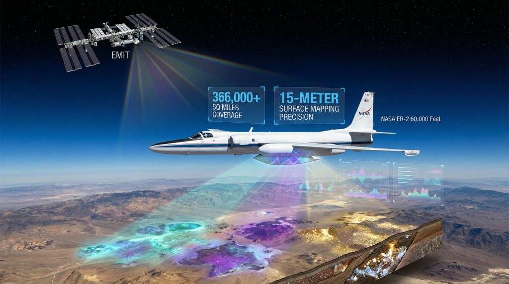
AVIRIS (Airborne Visible/Infrared Imaging Spectrometer) systems capture data at approximately 65,000 feet altitude, operating above most atmospheric interference whilst maintaining sufficient spatial resolution for detailed mineral mapping. The ER-2 aircraft platform provides stable data collection across swath widths of 11 kilometres, generating terabytes of hyperspectral information per flight mission.
Data processing involves complex atmospheric correction algorithms that account for water vapour absorption and aerosol interference. Furthermore, spectral unmixing techniques separate mixed pixel signatures into constituent mineral components, while machine learning classification achieves 80% accuracy for trained mineral categories when compared against verified ground truth samples.
When big ASX news breaks, our subscribers know first
Advanced Platform Specifications and Operational Capabilities
AVIRIS-5 represents the latest generation airborne platform, delivering 5-metre ground sample distance resolution across its operational range. The system operates with 224 contiguous spectral bands, providing detailed mineralogical analysis capabilities previously unavailable through satellite-based systems.
EMIT (Earth Surface Mineral Dust Source Investigation) functions as the complementary space-based platform aboard the International Space Station since July 2022. This system captures 285 spectral channels covering 380-2,500 nanometres with 60-metre pixel resolution, enabling global arid region coverage with 4-5 day revisit capability. NASA's mineral mapping technology represents a significant advancement in space-based mineral detection capabilities.
The operational distinction between airborne and space-based platforms creates strategic advantages for mineral exploration insights:
- Airborne advantages: Higher spatial resolution, flexible scheduling, real-time quality control
- Space-based advantages: Global coverage, continuous monitoring, lower cost per unit area
- Combined approach: Regional identification through EMIT, detailed follow-up through AVIRIS-5
Wavelength coverage enables detection across multiple mineral categories through specific absorption mechanisms. Visible spectrum analysis (400-700 nm) identifies iron oxides and surface oxidation minerals. Near-infrared coverage (700-1,300 nm) detects water-bearing minerals and vegetation discrimination. Shortwave infrared analysis (1,300-2,500 nm) reveals hydroxyl-bearing minerals including clays, micas, carbonates, and sulfates.
Mineral Detection Capabilities and Limitations
NASA mineral mapping technology successfully identifies multiple critical mineral categories through spectral analysis. Primary detection targets include lithium-bearing minerals such as spodumene, lepidolite, and petalite, identifiable through their characteristic absorption features in the US Geological Survey Spectral Library database.
Lithium-bearing clays including hectorite and montmorillonite show diagnostic spectral signatures enabling direct identification in evaporitic sequences. For instance, hectorite displays multiple absorption features around 1,900 and 2,200 nanometres, while lepidolite exhibits absorption at 2,250 nanometres through its lithium-mica structure.
| Mineral Category | Primary Targets | Detection Wavelength (nm) | Confidence Level |
|---|---|---|---|
| Lithium minerals | Spodumene, lepidolite, hectorite | 1,180-2,250 | High (80-85%) |
| Iron oxides | Hematite, limonite, jarosite | 900-2,200 | Very High (90%+) |
| Sulfates | Alunite, gypsum | 2,100-2,200 | High (85%) |
| Carbonates | Calcite, dolomite | 2,300 | Moderate (70%) |
Cobalt minerals including cobaltite and erythrite become detectable through their oxidation products. Erythrite, known as cobalt bloom, produces pink-coloured surface expressions with diagnostic spectral features enabling remote visual confirmation of underlying cobalt mineralisation.
Nickel detection occurs through garnierite and pentlandite identification via iron-nickel sulfide spectral signatures. However, detection depends on surface exposure and weathering conditions that produce identifiable oxidation zones.
Critical limitations constrain detection capabilities significantly. Rare earth elements cannot be directly detected through current hyperspectral systems due to weak electronic transitions in lanthanide 4f orbitals. Consequently, detection relies entirely on host mineral identification including monazite, bastnäsite, and xenotime parent rocks.
Subsurface deposits remain undetectable unless associated with surface alteration halos or weathering products. Vegetation interference reduces detection capability to less than 5% in forested regions, requiring seasonal surveys during leaf-off conditions for improved data quality.
Operational Constraints and Technical Challenges
Weather-dependent operational windows significantly impact survey scheduling and data quality. Cloud cover must remain below 10% for optimal data collection, limiting operational days to 60-180 annually depending on regional climate patterns.
Vegetation masking creates substantial detection challenges across forested terrain. Dense canopy coverage blocks ground-level mineral spectral signatures, with transmittance typically ranging 5-15% of incident radiation in visible and near-infrared wavelengths. However, deciduous winter conditions improve detection capabilities 3-4 fold compared to full-leaf summer surveys.
Spectral confusion between mineralogically similar compounds generates misclassification rates of 15-30% for phyllosilicate minerals such as montmorillonite versus illite. These errors require geological context and ancillary data for accurate drilling results interpretation.
Atmospheric interference introduces radiometric uncertainty through:
- Cirrus clouds: Spectral noise in 1,300-1,600 nm water absorption bands
- Aerosol optical depth: ±5-10% radiometric calibration uncertainty
- Water vapour variation: Requires complex atmospheric correction algorithms
Temporal resolution constraints limit change detection capabilities. Aircraft scheduling and weather dependencies prevent real-time monitoring, reducing effectiveness for dynamic geological processes or environmental monitoring applications.
Current Mapping Programme Scope and Coverage
The coordinated NASA-USGS mineral mapping initiative encompasses 366,000+ square miles across the American West during the 2023-2026 operational period. This coverage represents the largest systematic hyperspectral mineral survey in United States history.
Geographic prioritisation focuses on Nevada Basin and Range geological formations, Utah's mineral-rich desert corridors, and legacy mining areas requiring environmental assessment. Furthermore, these regions contain significant potential for lithium, cobalt, and rare earth deposits based on geological surveys and historical mining data.
EMIT global operations target arid and semi-arid regions between 60°N and 60°S latitude, providing systematic coverage of major global mineral provinces. The space-based platform identifies regional mineral distributions across Sahara, Middle East, Australian Outback, and southwestern United States desert systems. Advanced satellite technology enables comprehensive mineral mapping from space with unprecedented accuracy.
Annual coverage capability estimates suggest 100,000-150,000 square miles through AVIRIS-5 operations, dependent on weather windows and aircraft availability. Operating costs of $3,000-5,000 per flight hour constrain expansion rates and geographic coverage prioritisation.
USGS Hyperspectral Mapping Programme coordinates ground-truth verification across 380,000 square kilometres of California-Nevada battery mineral corridors. This programme provides essential calibration data for spectral classification algorithms and validation of remote sensing interpretations.
Critical Assessment: While mapping initiatives accelerate target identification, they represent only the initial phase of mineral development timelines. Discovery does not guarantee economic viability, environmental approval, or production capability.
Integration with Ground-Based Exploration Workflows
NASA mineral mapping technology transforms traditional exploration by reducing early-stage target generation costs 60-80% compared to conventional geological surveys. Spectral detection provides regional-scale prioritisation before expensive drilling programmes commence, supporting broader industry innovation trends.
The integration workflow follows systematic phases:
- Regional reconnaissance: EMIT identifies large-scale mineral provinces
- Detailed mapping: AVIRIS-5 provides high-resolution target delineation
- Ground verification: Geological teams confirm surface mineralisation
- Drill target selection: Core drilling tests subsurface grade and continuity
Cost reduction occurs primarily during pre-drilling phases. Traditional greenfield exploration requires extensive geological mapping, geochemical sampling, and geophysical surveys before drill target selection. In addition, hyperspectral mapping eliminates much reconnaissance work whilst improving drilling success rates.
Risk mitigation improves through environmental impact assessment integration. Spectral mapping identifies sensitive ecological areas, archaeological sites, and existing land use conflicts before exploration permits are submitted. This early identification reduces permitting delays and community opposition.
However, spectral detection does not eliminate subsequent development phases. Metallurgical testing, resource definition drilling, environmental baseline studies, and permitting processes remain unchanged regardless of discovery methods.
The next major ASX story will hit our subscribers first
Post-Detection Development Requirements
After spectral analysis identifies potential mineral deposits, extensive ground-based programmes determine economic viability. These programmes typically require 2-4 years for initial resource definition and 5-12 additional years for permitting and development.
Metallurgical testing becomes critical for determining processing requirements and recovery rates. Many lithium clay deposits identified through spectral analysis require complex extraction methods that significantly impact project economics. For instance, hectorite deposits may require acid leaching, evaporation concentration, or direct lithium extraction technologies not yet proven at commercial scale.
Resource definition drilling programmes verify grade, tonnage, and continuity of identified targets. Spectral detection indicates surface mineralisation but cannot determine:
- Subsurface grade distribution
- Deposit thickness and geometry
- Metallurgical recovery rates
- Environmental geochemical characteristics
Permitting processes remain independent of discovery methods. Environmental impact assessments, community consultation, water rights acquisition, and regulatory approvals follow standard timelines regardless of how deposits were initially identified.
Infrastructure development requirements often exceed mineral processing costs in remote locations. Power generation, water supply, transportation networks, and workforce housing create substantial capital requirements that spectral detection cannot address.
Strategic Implications for Mineral Supply Security
Domestic mineral mapping addresses critical supply chain vulnerabilities across battery materials and rare earth elements. Current import dependencies reach 100% for rare earth processing and 80%+ for lithium compounds, creating strategic risks for clean energy transition and defence applications.
NASA mineral mapping technology accelerates domestic resource identification but does not solve midstream processing bottlenecks. The United States maintains minimal rare earth separation capacity and limited lithium refining infrastructure regardless of upstream discoveries.
Timeline projections for domestic production capacity development extend 7-15 years from discovery to market supply. This duration includes:
- Resource definition: 2-4 years
- Environmental permitting: 3-7 years
- Construction and commissioning: 2-4 years
International competition intensifies as other nations develop similar remote sensing capabilities. China operates multiple hyperspectral satellites including Gaofen-5 and HJ-2 series, whilst European Space Agency advances similar programmes through Copernicus missions.
Supply chain independence requires coordinated development across multiple phases:
- Upstream: Resource identification and extraction capacity
- Midstream: Separation, refining, and processing infrastructure
- Downstream: Manufacturing capability for end-use products
Consequently, spectral mapping addresses only upstream challenges whilst midstream and downstream bottlenecks often determine supply chain resilience.
Technology Transfer from Planetary Science
Mars exploration missions provided foundational technology for terrestrial mineral mapping through Pancam and CRISM (Compact Reconnaissance Imaging Spectrometer for Mars) instrument development. These planetary science tools identified mineral distributions across Martian surface, demonstrating spectral analysis effectiveness in harsh environments.
Cross-platform sensor development enables rapid technology advancement between NASA missions. Techniques developed for asteroid mining advances transfer directly to Earth-based exploration through similar spectral analysis principles.
Commercial licensing opportunities expand private sector access to NASA-developed technologies. Companies including Planet Labs, Maxar Technologies, and Hyperspectral Solutions integrate similar spectral analysis capabilities into commercial satellite platforms.
International cooperation agreements facilitate global mineral security through data sharing protocols. NASA collaborates with European Space Agency, Canadian Space Agency, and other international partners to coordinate mineral mapping efforts and share technological advancement.
What Applications Exist Beyond Mineral Exploration?
Agricultural crop health monitoring utilises similar hyperspectral principles for precision farming applications. Vegetation stress detection through chlorophyll absorption analysis enables targeted irrigation, fertilisation, and pest management strategies.
Environmental contamination detection protocols leverage mineral identification capabilities for pollution monitoring. Heavy metal contamination, acid mine drainage, and industrial waste disposal sites become identifiable through characteristic spectral signatures.
Infrastructure integrity assessment applications use hyperspectral analysis for bridge condition monitoring, pipeline leak detection, and building material degradation analysis. Concrete carbonation, steel corrosion, and asphalt ageing create detectable spectral changes enabling predictive maintenance programmes. Furthermore, these applications integrate with data-driven mining operations to optimise resource management.
These diverse applications demonstrate the broad utility of hyperspectral remote sensing beyond mineral exploration, creating multiple revenue streams for technology development and operational cost reduction.
Future Technological Developments and Improvements
Enhanced spectral resolution development targets rare earth element direct detection through advanced sensor design. Next-generation systems may achieve sufficient signal-to-noise ratios for lanthanide absorption feature identification, eliminating current reliance on host rock indicators.
Artificial intelligence integration promises automated mineral classification with improved accuracy rates. Machine learning algorithms trained on expanded spectral libraries could achieve 95%+ classification accuracy whilst reducing false positive rates currently plaguing phyllosilicate discrimination.
Real-time data transmission capabilities enable immediate analysis and decision-making for exploration programmes. Satellite-linked data transmission could provide same-day spectral analysis results, accelerating exploration timelines and improving operational efficiency.
Quantum sensor development may revolutionise detection sensitivity and spectral resolution. Quantum-enhanced imaging systems could detect trace mineral concentrations currently below detection thresholds whilst improving spatial resolution to sub-metre accuracy.
How Do Commercial Partnerships Expand Program Capabilities?
Private sector collaboration frameworks facilitate technology transfer and operational cost sharing. Mining companies provide ground-truth verification data in exchange for priority access to spectral analysis results, creating mutually beneficial partnerships.
Data sharing protocols with extraction companies enable rapid target verification and development planning. Standardised data formats and analysis protocols accelerate integration between remote sensing and traditional exploration workflows.
International cooperation agreements expand global coverage whilst sharing operational costs. Collaborative missions with allied nations provide access to restricted territories and reduce individual programme expenses through shared infrastructure.
Commercial satellite integration multiplies coverage capability through private sector platforms. Companies like Planet Labs and Maxar Technologies offer complementary imaging capabilities that enhance government mapping programmes.
Addressing Common Questions and Misconceptions
Current hyperspectral systems cannot directly detect rare earth element concentrations due to weak electronic transitions in lanthanide compounds. Detection relies on identifying host minerals including monazite, bastnäsite, and xenotime that commonly contain rare earth elements.
Spectral analysis accuracy for economic reserves varies significantly by mineral type and geological environment. Surface mineralisation predictions achieve 70-85% accuracy, but subsurface grade distribution, continuity, and metallurgical characteristics require extensive drilling verification.
Environmental benefits from aerial surveying include reduced initial surface disturbance through targeted drilling programmes. Non-invasive mapping can reduce exploratory footprint by 75% whilst providing comprehensive regional mineral assessment capabilities.
Detection probability depends heavily on surface exposure percentage and mineral abundance. Most systems require >2% surface mineral exposure for reliable identification, limiting effectiveness in covered terrains or deeply weathered environments.
Economic Viability Assessment Beyond Initial Detection
Commercial viability determination extends far beyond spectral detection capabilities. Metallurgical processing complexity often determines project economics more significantly than grade or tonnage factors identified through remote sensing.
Infrastructure development requirements in remote locations frequently exceed mineral processing costs. Power generation, water supply systems, transportation networks, and workforce housing create substantial capital demands independent of resource characteristics.
Regulatory approval timelines vary dramatically by jurisdiction and mineral type. Federal lands permitting processes average 7-10 years for major projects, whilst state and private land development may require 3-5 years under optimal conditions.
Market demand stability influences project development decisions more than resource characteristics. Lithium price volatility, rare earth element demand fluctuations, and battery technology evolution create market risks that spectral detection cannot address.
What Are Realistic Development Timelines?
Complete development timelines from spectral detection to production typically require 7-15 years across multiple phases. Initial resource definition through drilling programmes consumes 2-4 years for comprehensive grade and tonnage determination.
Environmental permitting and regulatory approval processes require 5-12 years depending on project complexity, location, and community acceptance factors. Federal environmental impact assessments alone typically require 3-5 years for completion.
Construction and commissioning phases add 2-4 years to development timelines once all permits are secured. Complex metallurgical processing facilities require extensive engineering, procurement, and construction periods.
Investment risk factors remain substantial despite accelerated discovery timelines. Capital requirements for mine development typically range $100 million to $2+ billion depending on deposit size, processing complexity, and infrastructure requirements.
Investor Advisory: Spectral detection accelerates exploration phases but does not eliminate development risks including permitting delays, capital cost inflation, metallurgical challenges, or market demand fluctuations. Due diligence must encompass complete development timelines and associated risk factors.
Disclaimer: This analysis contains forward-looking projections regarding mineral development timelines, technological capabilities, and market conditions. Actual results may vary significantly due to regulatory changes, technological limitations, market fluctuations, and geological uncertainties. Readers should conduct independent research and consult qualified professionals before making investment or development decisions based on remote sensing data or mineral exploration prospects.
Looking to Capitalise on Cutting-Edge Mineral Discovery Technology?
Discovery Alert's proprietary Discovery IQ model provides instant notifications when significant ASX mineral discoveries are announced, including those identified through advanced technologies like NASA's hyperspectral systems. Whilst NASA technology accelerates initial target identification, Discovery Alert ensures you're immediately informed when Australian companies announce breakthrough discoveries that could transform into actionable investment opportunities. Begin your 30-day free trial today to gain the market-leading edge you need when the next major discovery hits the market.