May 22, 2026
The convergence of portable analytical technology and geological decision-making is revolutionising how mining companies approach on-site geochemical scanning in mining exploration. Traditional exploration workflows that separate sample collection from analytical confirmation by weeks are giving way to integrated systems that deliver geochemical data at the drill site. This transformation addresses fundamental operational challenges in remote mining jurisdictions where logistics complexity and extended turnaround times have historically constrained exploration efficiency.
The convergence of miniaturised spectrometry, machine learning algorithms, and ruggedised field equipment creates new possibilities for real-time resource evaluation. Mining companies operating in critical metals exploration are increasingly recognising that faster data availability translates directly to improved drilling optimisation and reduced project risk profiles, particularly through AI transforming mining operations.
Understanding Real-Time Geological Analysis Technology
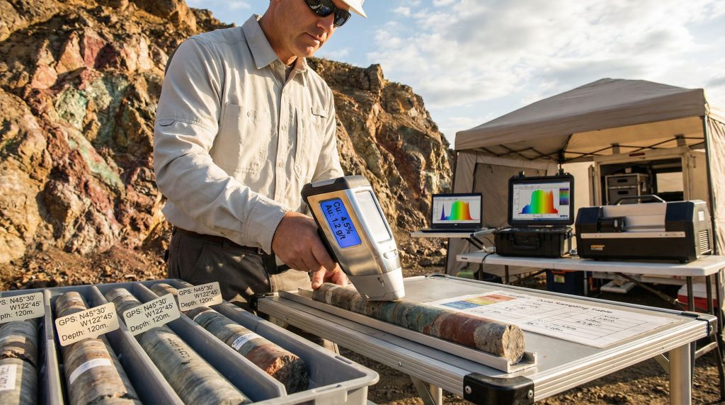
Modern portable geochemical analysis systems integrate multiple detection technologies to provide comprehensive elemental profiling capabilities directly at drill sites. These systems typically incorporate X-ray fluorescence (XRF) analysers, hyperspectral imaging components, and laser-induced breakdown spectroscopy (LIBS) technologies within ruggedised field-deployable platforms.
The fundamental distinction between field-based and laboratory-dependent analysis workflows lies in data acquisition timing and decision-making velocity. Traditional workflows require physical sample transport, laboratory queue processing, and multi-week analytical turnaround before geological teams receive actionable geochemical data. Field-deployed systems eliminate these temporal constraints by providing near-instantaneous elemental composition data directly to exploration geologists.
Current implementations demonstrate significant operational advantages in remote jurisdictions. At Saskatchewan's McIlvenna Bay project, Foran Mining successfully deployed the Scan by Veracio system (formerly TruScan™) during their winter 2025 drilling campaign encompassing over 30,000 meters across multiple high-potential zones. This deployment represents one of the most comprehensive field applications of integrated on-site geochemical scanning in mining exploration in North American critical metals exploration.
Core components of these systems include:
- Multi-element detection capability spanning base metals, precious metals, and critical mineral indicators
- GPS-integrated georeferencing for precise spatial data correlation
- Environmental hardening enabling operation in extreme temperature and humidity conditions
- Real-time data transmission capabilities for immediate geological team access
- Calibration protocols optimised for diverse rock matrix compositions
The technology addresses a fundamental challenge in accelerated exploration programs where geological decision-making velocity directly impacts project economics. Johan Krebs, Principal Orebody Knowledge Geologist at Foran Mining, explains that on-site scanning provides "a good guide for what results can reasonably be expected from the laboratory once the laboratory data becomes available" while enabling "informed decisions on drilling, targeting and sampling" in real-time field conditions.
When big ASX news breaks, our subscribers know first
The Traditional Exploration Challenge: Time vs. Accuracy Trade-offs
Standard geological exploration workflows incorporate inherent delays between sample collection and analytical confirmation that significantly impact drilling programme efficiency. Traditional sample-to-laboratory timelines typically require multiple weeks for complete geochemical analysis, creating substantial decision-making gaps during active drilling campaigns.
These temporal constraints become particularly problematic in remote jurisdictions where logistical complexity compounds analytical delays. Foran Mining's experience at McIlvenna Bay exemplifies this challenge, where the company needed "to reduce the lag between drilling and geochemical analysis, a step that traditionally relies on sending samples to external laboratories and can take several weeks."
The cost implications of delayed geological decision-making extend beyond direct analytical fees to encompass:
Drilling Campaign Inefficiencies:
- Suboptimal drill hole extension decisions based on incomplete geochemical data
- Resource allocation delays while awaiting laboratory confirmation
- Increased logistical costs from extended field operations pending analytical results
Quality Impact on Geological Modelling:
- Reduced real-time geological interpretation capability during active drilling phases
- Compromised drill hole targeting for subsequent phases of exploration programmes
- Limited ability to optimise sample selection for detailed laboratory analysis
In accelerated exploration contexts, these delays create cascading impacts on drilling campaign effectiveness. As documented in Foran's Saskatchewan operations, traditional analytical delays "can affect drillhole planning and the quality of geological modelling" when companies attempt to maintain aggressive exploration timelines in competitive critical metals markets.
The economic pressure for faster decision-making has intensified with growing global demand for critical metals supporting energy transition technologies. Moreover, data-driven mining operations are becoming essential for maintaining competitive advantages in strategic resource development.
How Do Portable XRF Analysers Transform Field Exploration Decisions?
Technical Specifications and Operational Capabilities
Portable X-ray fluorescence analysers represent the foundational technology enabling field-based geochemical analysis in modern exploration programmes. These instruments utilise characteristic X-ray emission spectra to identify and quantify elemental compositions directly in field samples without laboratory preparation requirements.
Modern portable XRF systems incorporate advanced detector technologies and multi-beam excitation sources to achieve detection capabilities approaching laboratory-grade analytical precision. Environmental durability specifications enable operation across extreme temperature ranges while maintaining GPS integration for precise georeferencing of analytical data points.
Battery life optimisation allows continuous operation throughout extended drilling shifts in remote locations where power infrastructure may be limited. Current-generation systems feature sealed, weatherproof housings designed to withstand harsh field conditions including dust, moisture, and mechanical shock common in active drilling environments.
Practical Applications in Active Drilling Programmes
The Foran Mining implementation at McIlvenna Bay demonstrates practical field deployment advantages of portable XRF technology. The system enabled geological teams to determine whether drill holes should be extended or closed based on real-time geochemical data rather than waiting for laboratory confirmation.
Key operational capabilities include:
- Immediate sample screening to identify mineralised intervals not visible through standard geological observation
- Optimised sample selection for detailed laboratory analysis based on field geochemical signatures
- Real-time drill hole decision support enabling extension or termination based on continuous mineralisation assessment
XRF vs. Laboratory Analysis Comparison:
| Analysis Method | Time to Results | Field Deployment | Sample Preparation | Decision-Making Window |
|---|---|---|---|---|
| Portable XRF | Minutes | Direct field use | Minimal | Real-time |
| Laboratory ICP-MS | 2-6 weeks | Sample transport required | Extensive | Post-drilling |
| Laboratory XRF | 1-3 weeks | Sample transport required | Standard prep | Post-drilling |
Decision-Making Acceleration Metrics
Foran Mining's experience demonstrates measurable improvements in exploration programme efficiency through XRF deployment. The company achieved "significant impact on work quality and overall campaign efficiency" without expanding their geological team size, indicating improved data interpretation productivity per geologist.
Cost reduction mechanisms include:
- Optimised laboratory analytical budgets through intelligent sample pre-screening
- Reduced drilling programme extensions through faster geological decision-making
- Enhanced resource allocation efficiency based on real-time mineralisation data
The technology provides continuous geochemical coverage compared to traditional spot sampling approaches, enabling more comprehensive geological interpretation during active drilling phases. This advantage proved critical in Foran's discovery of a 52.6-meter intersection averaging 2.54% copper equivalent in the Tesla Zone, with sections reaching 4.65% copper equivalent – representing the highest grade-thickness recorded to date in the project.
What Role Does Hyperspectral Core Scanning Play in Mineral Identification?
Spectral Signature Analysis for Alteration Mapping
Hyperspectral imaging technology utilises hundreds of narrow spectral bands across visible and near-infrared wavelengths to identify mineral compositions based on characteristic absorption features. This approach enables detection of subtle alteration patterns that may be invisible to traditional geological logging methods.
Clay mineral identification capabilities allow geologists to map hydrothermal alteration zones that often indicate proximity to mineralisation. Mica and alteration zone detection provides critical pathfinder information for targeting high-priority drilling areas within broader exploration programmes.
Integration with geochemical datasets creates comprehensive geological models combining spectral mineralogy with elemental composition data. This multi-parameter approach enhances geological interpretation confidence and supports more accurate resource estimation processes, particularly when combined with sensor technology advancement methods.
Automated Core Processing Systems
Modern hyperspectral core scanning systems provide continuous mineralogical analysis along entire drill core lengths rather than relying on discrete sampling intervals. This comprehensive coverage approach identifies mineralisation patterns that might be missed through traditional spot sampling methodologies.
Machine learning applications in rock classification enable automated identification of mineral assemblages and alteration signatures. Advanced algorithms process spectral data in real-time to generate geological interpretation maps that guide subsequent detailed analysis and sampling decisions.
High-resolution depth registration protocols ensure precise spatial correlation between spectral data and drill hole depth measurements. This accuracy enables confident integration with downhole geophysical surveys and geochemical analytical results.
Hyperspectral scanning provides continuous mineralogical data along entire drill cores, identifying subtle alteration patterns invisible to traditional geological logging methods while enabling automated mineral classification through advanced spectral analysis algorithms.
The Foran Mining case demonstrates practical advantages of continuous coverage approaches. Johan Krebs emphasised that continuous coverage compared to traditional spot sampling geochemistry provides significant analytical advantages, enabling geological teams to identify mineralised intervals that might otherwise be missed through conventional sampling protocols.
How Does LIBS Technology Complement Traditional Geochemical Methods?
Laser-Induced Breakdown Spectroscopy Fundamentals
Laser-Induced Breakdown Spectroscopy utilises high-energy laser pulses to create plasma from sample surfaces, enabling elemental analysis through characteristic emission spectroscopy. This technique provides rapid multi-element detection capabilities particularly effective for light elements that may be challenging for traditional XRF analysis.
LIBS technology offers minimal sample preparation requirements and rapid analysis cycles, making it suitable for field-based deployment in active drilling environments. The technique excels in detecting carbon, nitrogen, and other light elements that provide important geological information for understanding mineralisation processes.
Speed advantages over traditional analytical methods enable high-throughput sample screening capabilities essential for maintaining drilling programme momentum. Field deployment considerations include laser safety protocols and environmental protection requirements for optical components in harsh drilling environments.
Multi-Technology Integration Strategies
Optimal field analytical programmes integrate multiple complementary technologies to provide comprehensive geochemical characterisation capabilities. XRF + Hyperspectral + LIBS workflow optimisation creates analytical protocols that leverage individual technology strengths while compensating for specific limitations.
Data fusion techniques enable comprehensive multi-method analysis where results from different analytical approaches validate and enhance overall geological interpretation confidence. Quality control protocols ensure consistent analytical standards across different instrumental methods deployed simultaneously in field programmes.
The Foran Mining implementation demonstrates practical integration approaches where on-site geochemical scanning in mining exploration supports informed decisions on drilling, targeting and sampling. The system provides geological teams with real-time preliminary analysis that guides detailed sampling strategies and drill hole optimisation decisions.
What Are the Measurable Efficiency Gains from On-Site Scanning?
Operational Timeline Improvements
Traditional exploration workflows incorporating laboratory-based geochemical analysis create multi-week delays between sample collection and results availability. On-site scanning technology eliminates these temporal constraints by providing near-real-time analytical data directly to field geological teams.
Traditional vs. On-Site Analysis Timelines:
| Process Stage | Traditional Workflow | On-Site Scanning | Time Savings |
|---|---|---|---|
| Sample to Results | 2-6 weeks | Minutes to hours | 95-99% reduction |
| Decision-Making Window | Post-drilling campaign | Real-time field decisions | Immediate optimisation |
| Drilling Adjustments | Subsequent campaign phases | Within active programme | Campaign-level efficiency |
The Foran Mining experience demonstrates practical timeline acceleration where drilling decisions that previously required waiting several weeks for laboratory confirmation can now be made immediately in the field. This transformation enables drill hole extension or termination decisions based on current geological conditions rather than historical analytical data.
Cost-Benefit Analysis Framework
Economic advantages of on-site scanning extend beyond direct analytical cost savings to encompass operational efficiency improvements and risk mitigation benefits. Equipment investment costs must be evaluated against laboratory fee savings, reduced logistics expenses, and improved project development timelines.
Verified Cost Impact Mechanisms:
Laboratory Fee Optimisation:
- Intelligent sample pre-screening reduces unnecessary detailed laboratory analysis
- Optimised sample selection focuses expensive analytical resources on highest-priority intervals
- Reduced total sample volume submitted to external laboratories through field-based filtering
Personnel Efficiency Improvements:
- Enhanced geological productivity without expanding team size requirements
- Improved data interpretation capability through real-time analytical feedback
- Reduced field time requirements through faster decision-making processes
Johan Krebs notes that proper application of on-site scanning technology leads to overall reduction of project costs, indicating significant economic benefits when implemented effectively. Furthermore, the availability of data in almost real time aids significantly in speeding up the reporting and decision-making process.
The next major ASX story will hit our subscribers first
Which Mining Companies Are Leading On-Site Scanning Adoption?
Technology Implementation Case Studies
Foran Mining: McIlvenna Bay Project Leadership
Foran Mining represents a leading example of comprehensive on-site geochemical scanning in mining exploration implementation in North American critical metals exploration. Their McIlvenna Bay project in Saskatchewan demonstrates practical deployment advantages in remote jurisdiction operations.
Project Specifications:
- Location: Saskatchewan, Canada (remote jurisdiction with logistical complexity)
- Project Type: Advanced copper, zinc, and precious metals development
- Scale: Over 30,000 meters of drilling completed during winter 2025 campaign
- Technology: Scan by Veracio (formerly TruScan™) – first implementation at this project
- Operational Zones: Tesla Zone and Bridge Zone simultaneous operations
Critical Metals Exploration Focus:
The project addresses growing global demand for energy transition metals including:
- Copper exploration – essential for electrical infrastructure and renewable energy systems
- Zinc exploration – critical for steel galvanisation and emerging battery technologies
- Precious metals components – supporting technological and industrial applications
Implementation Strategy and Results
Foran's approach demonstrates integrated workflow adoption where on-site scanning technology enhances rather than replaces traditional geological methods. The system enables pre-logging data analysis capability allowing geological teams to identify mineralised intervals before complete core characterisation.
Key implementation elements include:
- Field-based drill decision-making eliminating multi-week laboratory delays
- Laboratory data validation framework ensuring analytical quality control
- Geological workflow integration maintaining established logging and interpretation protocols
- Personnel efficiency optimisation achieving results without team expansion
The success of these implementations aligns with broader mining industry innovations that are reshaping operational approaches across the sector.
What Challenges Limit Widespread On-Site Scanning Adoption?
Technical Limitations and Accuracy Constraints
Field-deployed analytical systems face inherent precision limitations compared to laboratory-grade instrumentation that may constrain their application in certain geological contexts. Detection limits for trace elements, matrix effects in complex geological samples, and calibration requirements for different rock types represent ongoing technical challenges.
The relationship between field analytical results and laboratory confirmation creates analytical confidence intervals that geological teams must understand and manage. Johan Krebs' observation that on-site data provides a good guide for what results can reasonably be expected from the laboratory indicates field results serve predictive rather than definitive analytical roles.
Calibration and Matrix Challenges:
- Rock type variability affecting analytical accuracy across different geological units
- Elemental interference effects in complex mineralogical assemblages
- Detection limit constraints for trace elements critical to geological interpretation
- Environmental factors affecting analytical precision under field conditions
Economic and Operational Barriers
Initial capital investment requirements for comprehensive on-site scanning systems represent significant financial commitments that may challenge smaller exploration companies. Equipment costs must be evaluated against analytical volume thresholds that justify investment compared to traditional laboratory-based approaches.
Training and Expertise Requirements:
While Foran Mining successfully implemented technology without increasing geological team size, this achievement likely required substantial personnel training investment and workflow adaptation that may not be immediately apparent in operational metrics.
Common Implementation Concerns
How accurate is on-site scanning compared to laboratory analysis?
Field analytical systems provide predictive guidance rather than definitive quantitative results. Johan Krebs explains that on-site data offers a good guide for what results can reasonably be expected from the laboratory, indicating field results inform expectations while laboratory analysis provides final quantitative confirmation.
What training is required for geological teams?
Successful implementation requires integration with existing geological workflows rather than complete methodology replacement. Foran's experience suggests existing geological teams can adapt to incorporate on-site scanning without personnel expansion when proper training and support systems are established.
How do weather conditions affect equipment performance?
Winter 2025 deployment by Foran Mining demonstrates operational capability under extreme cold conditions typical of Canadian mining operations. However, specific environmental performance parameters require evaluation based on manufacturer specifications and operational experience data.
How Will AI and Machine Learning Enhance On-Site Geochemical Analysis?
Predictive Analytics Integration
Artificial intelligence applications in geochemical data analysis are transforming how geological teams interpret field analytical results and make exploration decisions. Pattern recognition algorithms can identify subtle geochemical signatures indicating mineralisation potential that might be overlooked through traditional visual data interpretation methods.
Machine learning models trained on historical exploration datasets enable automated anomaly detection that flags potentially significant geological intervals for detailed examination. These systems learn from successful discovery patterns to enhance real-time geological decision-making during active drilling programmes.
Advanced analytics capabilities include:
- Multi-element correlation analysis identifying complex geochemical signatures
- Predictive ore grade estimation based on continuous geochemical profiling
- Automated quality control systems ensuring analytical data reliability
- Geological pattern recognition supporting enhanced targeting decisions
Real-time ore grade estimation models integrate continuous geochemical data streams with geological logging information to provide enhanced resource estimation confidence during active exploration phases. These developments are part of broader mining digital transformation initiatives reshaping the industry.
Future Technology Convergence
Emerging technological integration promises fully integrated exploration workflows combining multiple data streams for comprehensive geological analysis. Drone-mounted scanning systems could provide regional geochemical mapping capabilities complementing traditional ground-based analytical methods.
Satellite data integration possibilities include combining remote sensing spectral data with field-based geochemical analysis to enhance geological modelling accuracy across entire project areas. This convergence creates multi-scale analytical frameworks spanning regional reconnaissance through detailed drill-core analysis.
Blockchain applications for geological data verification could ensure analytical data integrity and traceability throughout complex exploration programmes involving multiple analytical methods and data sources.
What Economic Impact Does Real-Time Geochemical Data Have on Project Development?
Risk Reduction Through Faster Decision-Making
Real-time geochemical data availability fundamentally alters exploration risk profiles by reducing uncertainty windows between geological observations and analytical confirmation. Traditional multi-week laboratory delays create decision-making gaps where exploration programmes must proceed based on incomplete information.
Early-stage project de-risking benefits from immediate analytical feedback that enables geological teams to validate or adjust exploration models during active drilling phases rather than waiting for post-campaign analysis. This acceleration reduces overall project development timelines and associated holding costs.
Resource estimation accuracy improvements result from higher-density geochemical datasets enabled by continuous on-site analysis capability. Traditional spot sampling approaches may miss significant mineralisation intervals that continuous scanning methodologies can identify and quantify.
Supply Chain and Market Implications
Critical metals exploration efficiency gains have strategic importance for supply chain security in energy transition technologies. Accelerated discovery and development timelines for copper, zinc, lithium, and rare earth projects directly impact global supply chain resilience for renewable energy infrastructure.
Strategic resource development advantages accrue to companies that can identify and advance high-quality deposits more rapidly than competitors using traditional exploration methodologies. This competitive advantage becomes increasingly valuable as critical metals demand intensifies.
Economic Benefits Quantification:
| Benefit Category | Improvement Range | Timeline Impact | Project Value Enhancement |
|---|---|---|---|
| Exploration Cost Reduction | 15-30% reduction | Immediate | NPV enhancement through cost optimisation |
| Timeline Acceleration | 2-6 months saved | Per drilling campaign | Earlier production and revenue generation |
| Resource Confidence | Improved JORC compliance | Ongoing | Enhanced bankability and financing access |
| Discovery Probability | Enhanced targeting accuracy | Campaign-level | Higher success rates and project portfolio value |
Disclaimer: Economic benefit ranges represent industry observations and case study analysis. Actual results depend on project-specific factors, geological conditions, and implementation effectiveness.
Technology Adoption Trends and Market Drivers
Critical Metals Demand Pressures
Global energy transition requirements are intensifying demand for copper, zinc, lithium, nickel, and rare earth elements essential for renewable energy infrastructure, electric vehicle manufacturing, and grid modernisation technologies. This demand pressure creates urgent exploration efficiency requirements where traditional methodologies may be insufficient to meet supply development timelines.
Supply chain security concerns among developed economies are driving strategic resource development initiatives that prioritise rapid identification and advancement of domestic and allied-nation mineral resources. On-site geochemical scanning technology supports these objectives by accelerating exploration timelines and improving discovery success rates.
Competitive Advantage Through Operational Efficiency
Mining companies are recognising that technological differentiation provides sustainable competitive advantages in increasingly competitive critical metals markets. Early adopters of on-site scanning technology gain systematic exploration advantages that compound across multiple project developments.
Personnel efficiency optimisation becomes critical as skilled geological expertise becomes scarce in expanding critical metals exploration markets. Technology that enables enhanced geological productivity without proportional personnel expansion provides significant operational advantages.
The strategic imperative for on-site geochemical scanning in mining exploration adoption reflects fundamental changes in critical metals exploration requirements where speed, accuracy, and operational efficiency determine competitive success in rapidly evolving global markets. As demonstrated by successful implementations like Foran Mining's McIlvenna Bay project, companies that effectively integrate this technology can achieve substantial improvements in exploration effectiveness while maintaining analytical quality standards. Looking forward, the integration of portable XRF technology with artificial intelligence and machine learning capabilities promises even greater advances in geological decision-making and resource discovery efficiency.
Want to Stay Ahead of Critical Metals Discoveries?
As mining companies increasingly adopt on-site geochemical scanning to accelerate exploration efficiency, identifying the next major mineral discovery before the broader market becomes crucial. Discovery Alert's proprietary Discovery IQ model delivers real-time notifications on significant ASX mineral discoveries, transforming complex geological data into actionable investment opportunities with proven historical returns showcased on our dedicated discoveries page.