June 4, 2026
Continental river systems undergo dramatic transformations when ancient lake basins reach critical spillover thresholds, creating some of the world's most spectacular geological formations through cascading drainage events. These hydrological processes demonstrate how temporary water bodies can permanently reshape entire drainage networks across millions of years. Understanding the mineral exploration importance helps geologists analyse the formation of the Grand Canyon through careful examination of preserved sedimentary records.
Understanding the Geological Mechanisms Behind Canyon Carving
Canyon formation through prehistoric lake Grand Canyon formation processes represents a sophisticated interplay between hydraulic forces and geological resistance. When ancient water bodies exceed their natural containment barriers, the resulting overflow creates powerful erosional systems capable of carving through solid bedrock at accelerated rates.
The spillover mechanism operates through several distinct phases:
• Initial overflow establishment – Water breaches the lowest point of natural barriers
• Headcut retreat progression – Waterfalls migrate backward through sustained erosion
• Channel deepening acceleration – Increased flow volumes enhance cutting capacity
• System integration completion – Connected drainage networks form permanent pathways
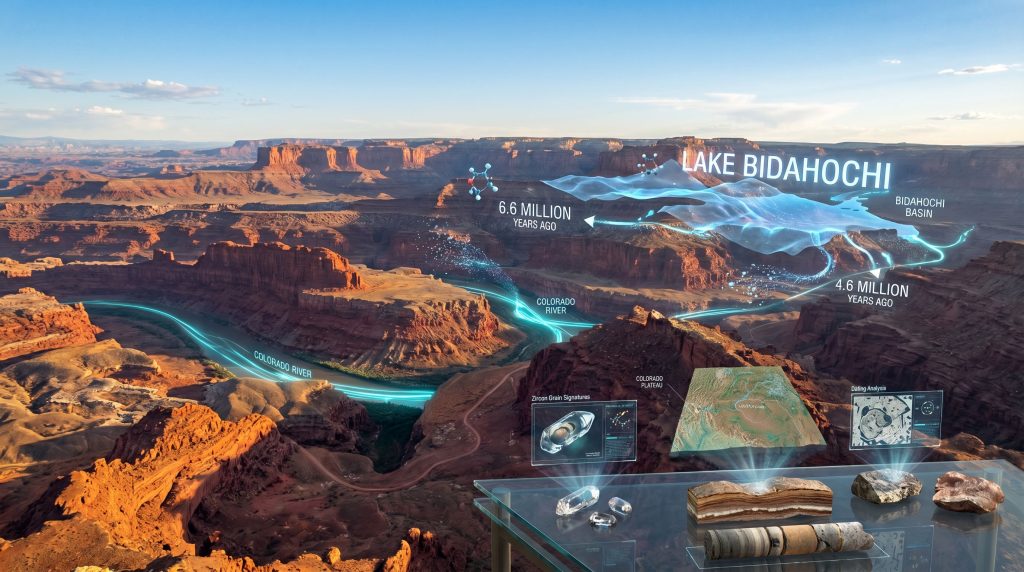
Modern geological analysis reveals that Lake Bidahochi's spillover event approximately 6 million years ago initiated a cascade of erosional processes that fundamentally altered southwestern drainage patterns. The U.S. Geological Survey research demonstrates how multiple natural processes including lake spillover, river incision, and changes in regional topography worked together to shape the Grand Canyon's modern form.
This multi-process integration model represents a significant advancement from earlier single-mechanism theories. Rather than attributing canyon formation to purely catastrophic events, contemporary understanding emphasises the coordinated action of various geological forces operating across extended timeframes.
The research methodology employed detrital zircon mineral grain analysis, comparing ages of preserved grains to known early Colorado River sediments. This sophisticated paleomagnetic approach provides temporal precision unavailable during John Wesley Powell's pioneering expeditions in the 1870s. Furthermore, mineralogy and mining economics principles help scientists understand how different mineral compositions reveal ancient geological processes.
When big ASX news breaks, our subscribers know first
What Role Did Lake Bidahochi Play in Grand Canyon Development?
Lake Bidahochi functioned as a critical hydrological nexus in the prehistoric lake Grand Canyon formation process, serving as both a temporary storage system for ancestral Colorado River waters and the ultimate source of spillover flooding that carved the canyon's initial pathways.
Ancient Lake Basin Characteristics
The prehistoric water body occupied the present-day Bidahochi Basin east of Flagstaff, Arizona, primarily on Navajo land, spanning approximately 10 million years from 16 to 6 million years ago. During this extended period, the lake accumulated substantial sedimentary deposits while serving as the terminus for ancestral Colorado River drainage.
Key temporal markers include:
| Time Period | Lake Status | Evidence Type |
|---|---|---|
| 16-6.6 MYA | Isolated basin system | Local mineral signatures only |
| 6.6-4.6 MYA | Colorado River connection | Mixed mineral assemblages |
| 4.6 MYA-Present | Fully integrated drainage | Consistent river signatures |
Spillover Mechanism and Canyon Initiation
The catastrophic drainage event occurred when Lake Bidahochi reached critical capacity around 6 million years ago. Overflow across natural barriers initiated waterfall formations that progressively retreated backward, cutting deeper into bedrock layers through sustained hydraulic erosion.
This spillover process created the initial drainage pathway that would eventually become the Grand Canyon. However, the USGS research emphasises that spillover represented just one component of a more complex formation system rather than the exclusive mechanism.
The lake's role extended beyond simple overflow generation. 200-foot thick sediment sequences preserved in eastern basin regions provide detailed records of depositional conditions, while ancient shoreline features remain visible along former lake margins, offering tangible evidence of the water body's extent and duration.
Geographic and Temporal Precision
Research focused specifically on mineral grains preserved in ancient lake deposits within the Bidahochi Basin. The geographic specificity enables independent verification through geological mapping and site investigation, while the 6.6 million year timeline for initial Colorado River material arrival provides temporal anchoring for formation theories.
The transition from isolated basin conditions to full river system integration occurred over approximately 2 million years, demonstrating that canyon formation involved gradual processes alongside more dramatic spillover events. Additionally, understanding mineral deposit tiers helps classify the economic significance of various geological formations found throughout the region.
How Do Mineral Grain Signatures Reveal Ancient River Connections?
Mineral provenance analysis through detrital zircon methodology provides direct evidence for hydrological connectivity between ancient river systems and lake basins. This analytical approach enables researchers to trace sediment sources across geological time by comparing distinctive mineral age populations.
Zircon Analysis Methodology and Precision
The research team extracted zircon mineral grains from ancient lake sediment deposits, applying radiometric dating techniques to establish individual grain ages. By comparing these age populations with known Colorado River sediment signatures, scientists identified precisely when river material first reached Lake Bidahochi.
The analytical process involves:
- Sample extraction from preserved sedimentary sequences
- Zircon isolation using standard mineral separation techniques
- Radiometric dating of individual grains (uranium-lead methodology)
- Statistical comparison with established river sediment signatures
- Temporal correlation to establish connectivity timelines
Zircon dating achieves precision of approximately ±1-2% for samples spanning millions of years, providing reliable temporal resolution for establishing drainage system evolution. Furthermore, interpreting drill results from modern geological surveys follows similar analytical principles to understand subsurface mineral distributions.
Critical Temporal Transitions
Beginning approximately 6.6 million years ago, sand within Lake Bidahochi deposits exhibits clear and distinct Colorado River signatures, marking the initial establishment of hydrological connectivity between Rocky Mountain headwaters and southwestern basin systems.
This transition from local mineral signatures to mixed assemblages indicates progressive system integration rather than instantaneous connection. The 2-million-year integration window demonstrates that full drainage network connectivity required sustained geological processes operating across extended timeframes.
Evidence indicates the river system achieved full integration approximately 4.6 million years ago, connecting headwaters in the Rockies through the Grand Canyon to the Gulf of California outlet. This timeline establishes the modern Colorado River configuration and marks the completion of major canyon-carving processes.
Sediment Transport Pathway Documentation
The progression from isolated basin conditions to integrated drainage networks reflects fundamental changes in regional hydrology. Local mineral signatures dominated during the pre-6.6 million year period, when Lake Bidahochi received sediments exclusively from surrounding highlands.
The appearance of Colorado River signatures marks the establishment of long-distance sediment transport pathways spanning hundreds of miles from Rocky Mountain sources to southwestern depositional basins. This transition represents one of the most significant drainage reorganisation events in North American geological history.
What Alternative Formation Theories Compete with Lake Spillover?
Multiple competing models attempt to explain prehistoric lake Grand Canyon formation processes, reflecting the complexity of large-scale landscape evolution and the challenges inherent in reconstructing ancient geological events from limited evidence.
Contemporary Multi-Process Framework
The U.S. Geological Survey research supports an integrative model emphasising that multiple natural processes worked together to shape the Grand Canyon's modern form. This approach represents a significant departure from earlier single-mechanism theories that attributed canyon formation to exclusively catastrophic or exclusively gradual processes.
The multi-process framework incorporates:
• Lake spillover events establishing initial drainage pathways
• River incision processes deepening existing channels through sustained erosion
• Regional topographic changes affecting overall drainage pattern configuration
• Tectonic influences modifying landscape geometry over geological time
This integrative perspective reflects contemporary geological consensus and demonstrates how scientific understanding evolves through accumulation of evidence and analytical sophistication.
Headward Erosion Alternative Model
Traditional headward erosion theories propose that the Colorado River gradually extended its drainage network westward through progressive channel incision, without requiring large-scale lake systems or catastrophic drainage events. This model emphasises sustained erosional processes operating over extended timeframes.
Proponents of headward erosion models argue that:
- Gradual channel extension provides sufficient time for deep canyon carving
- No extraordinary hydrological events are required for formation
- Sustained river flow can account for observed erosional features
- Regional drainage patterns support progressive network development
However, the USGS mineral grain analysis provides direct evidence for ancient lake system involvement, challenging purely gradual formation theories. In addition, research published in Science supports the spillover model through comprehensive geological evidence.
Historical Scientific Evolution
Scientific discussion about Grand Canyon formation began with John Wesley Powell's expeditions starting in 1869. Powell navigated the Colorado River by boat, advanced early theories about canyon origins and western drainage systems, and demonstrated the national need for dedicated geological investigation.
Powell's pioneering work contributed to the creation and mission of the USGS in 1879, establishing institutional framework for systematic geological research. Contemporary studies represent the advancement of these foundational investigations through modern analytical methods and expanded theoretical perspectives.
The evolution from Powell's initial observations to current multi-process models demonstrates how geological understanding progresses through technological advancement, expanded data collection, and refined theoretical frameworks.
How Has Scientific Understanding Evolved Since Powell's Era?
The transformation from 19th-century geological exploration to contemporary analytical capabilities represents one of the most dramatic advances in earth science methodology and theoretical sophistication.
Powell's Foundational Contributions (1869-1879)
John Wesley Powell's Colorado River expeditions established fundamental principles of western drainage system analysis through direct field observation and systematic documentation. His work demonstrated how sustained river flow could carve through solid rock formations, providing early insights into erosional processes.
Powell's expeditions contributed to:
- Systematic geological mapping of western drainage networks
- Recognition of erosional processes in canyon formation
- Documentation of regional geological structures
- Establishment of USGS institutional framework in 1879
These foundational investigations created the institutional and theoretical basis for subsequent geological research, though analytical capabilities remained limited to direct field observation and basic stratigraphic analysis.
Modern Analytical Revolutionisation
Contemporary geological research employs sophisticated analytical techniques unavailable during Powell's era, enabling precision investigation of ancient processes through multiple independent methodological approaches.
Current analytical capabilities include:
• Isotopic dating systems providing temporal precision to ±1-2% accuracy
• Paleomagnetic analysis for temporal correlation across regions
• Digital terrain modelling enabling drainage reconstruction
• Mineral provenance analysis tracing sediment sources across geological time
• Advanced statistical methods for data interpretation and uncertainty quantification
These technological advances enable researchers to test specific hypotheses about ancient processes through quantitative evidence rather than relying exclusively on qualitative field observations. Moreover, 3D geological modelling provides sophisticated visualisation tools for understanding complex subsurface structures and formation processes.
Institutional Collaboration and Expertise
The USGS research involved collaboration between four major institutions: the U.S. Geological Survey, Arizona Geological Survey, University of California Los Angeles, and Paradise Valley Community College Phoenix. This multi-institutional approach reflects the complexity of modern geological investigation and the necessity for diverse expertise.
Research team leader Ryan Crow emphasised how mineral grain tracing enables precise determination of when Colorado River material first reached ancient lake systems, providing direct evidence for hydrological connectivity that earlier methods could not establish.
The study's publication in Science magazine indicates successful peer review in a premier scientific publication, demonstrating the research meets rigorous academic standards for methodology, evidence quality, and theoretical significance.
What Does Current Evidence Reveal About Timeline and Processes?
Comprehensive analysis of preserved geological evidence establishes a detailed chronological framework for prehistoric lake Grand Canyon formation processes, spanning approximately 10 million years of systematic landscape evolution.
Critical Formation Periods and Transitions
The formation timeline divides into distinct phases characterised by different hydrological configurations and erosional processes:
16-6.6 Million Years Ago: Isolated Basin Phase
- Lake Bidahochi functions as closed drainage system
- Sediment accumulation from local sources only
- Minimal connectivity to regional drainage networks
- Gradual sedimentary buildup creating preservation conditions
6.6-4.6 Million Years Ago: Integration Initiation Phase
- Initial Colorado River material reaches lake basin
- Mixed mineral assemblages indicate transitional connectivity
- Progressive drainage network development
- Spillover event establishment around 6 million years ago
4.6 Million Years Ago-Present: Fully Integrated Phase
- Complete river system connectivity established
- Consistent Colorado River sediment signatures
- Sustained canyon carving through integrated flow
- Modern drainage configuration achievement
Preserved Geological Evidence Documentation
Physical evidence for ancient lake systems and drainage evolution remains visible throughout the Bidahochi Basin region, providing multiple independent lines of supporting evidence.
Key preservation features include:
| Evidence Type | Characteristics | Scientific Significance |
|---|---|---|
| Sediment Sequences | 200-foot thickness in eastern regions | Indicates sustained depositional conditions |
| Shoreline Features | Preserved along former lake margins | Documents maximum lake extent |
| Stratified Deposits | Layered lacustrine sediments | Demonstrates prolonged lake existence |
| Overflow Channels | Remnant drainage pathways | Suggests catastrophic spillover events |
This diverse evidence base enables cross-validation of formation theories through multiple independent analytical approaches.
Quantitative Temporal Precision
The 2-million-year integration window between initial connectivity (6.6 MYA) and full system development (4.6 MYA) indicates that canyon formation involved both gradual and episodic processes operating across different temporal scales.
Mineral grain analysis provides temporal resolution sufficient to distinguish between competing formation theories, with statistical confidence levels supporting the multi-process integration model over single-mechanism alternatives.
The transition from mixed mineral assemblages to consistent Colorado River signatures documents progressive drainage network maturation rather than instantaneous system establishment, supporting evolutionary rather than purely catastrophic formation models.
The next major ASX story will hit our subscribers first
Why Does This Research Matter for Understanding Landscape Evolution?
The Lake Bidahochi spillover research provides crucial insights into how large-scale landscape modification occurs through complex interactions between geological, hydrological, and tectonic processes operating across extended timeframes.
Implications for Regional Geological Understanding
The prehistoric lake Grand Canyon formation model demonstrates how ancient hydrological systems can fundamentally reshape continental drainage patterns through threshold effects and cascade processes. This understanding applies to landscape evolution analysis worldwide.
Key implications include:
- Threshold behaviour recognition in geological systems
- Multi-process integration in landscape formation
- Temporal scale considerations for erosional processes
- Regional connectivity in drainage network evolution
These principles inform geological interpretation beyond the specific Grand Canyon context, providing frameworks for understanding similar landscape evolution processes in other continental settings.
Broader Scientific and Educational Significance
The research demonstrates how technological advancement enables retrospective investigation of ancient processes through preserved evidence, expanding scientific understanding of Earth system evolution.
Educational implications encompass:
• Methodological sophistication in geological investigation
• Interdisciplinary collaboration across institutional boundaries
• Evidence-based hypothesis testing in historical sciences
• Technological application to fundamental geological questions
This work exemplifies how systematic scientific investigation can resolve long-standing theoretical debates through accumulation of quantitative evidence and analytical precision.
Future Research Directions and Applications
The mineral provenance methodology employed in Lake Bidahochi research offers potential applications to drainage evolution studies in other regions, particularly where ancient lake systems may have influenced landscape development.
Similar analytical approaches could illuminate:
- Paleodrainage reconstruction in tectonically active regions
- Climate-hydrology interactions in ancient systems
- Sediment transport pathways across geological time
- Landscape sensitivity to environmental change
This research establishes methodological frameworks applicable to global geological investigation and demonstrates how collaborative institutional approaches can address complex earth science questions.
Research Disclaimer: The findings presented represent current scientific understanding based on available evidence and analytical methods. Geological interpretations may evolve as additional data becomes available and analytical techniques advance. This research focuses specifically on Lake Bidahochi's role in Grand Canyon formation and may not apply directly to other geological contexts without independent validation.
Want to Capitalise on Geological Discoveries in ASX Mining Companies?
Discovery Alert's proprietary Discovery IQ model delivers real-time alerts on significant mineral discoveries across Australian exploration companies, instantly transforming complex geological data into actionable investment insights. Explore how major mineral discoveries can generate substantial returns by visiting Discovery Alert's dedicated discoveries page, then begin your 14-day free trial to position yourself ahead of the market.