June 19, 2026
Why Subsurface Intelligence Has Become the Hidden Engine of Modern Mining and Infrastructure
The resource extraction and civil infrastructure industries have long operated under a deceptively simple assumption: drill enough holes, collect enough samples, and the ground will reveal its secrets. For most of the twentieth century, Seequent subsurface imaging systems were not yet part of the conversation. Boreholes were logged by hand, geophysical surveys were interpreted on paper profiles, and geological cross-sections were drafted by experienced practitioners working from fragmented, disconnected datasets.
That approach no longer holds. The scale, complexity, and commercial stakes of modern mining and infrastructure projects have fundamentally outpaced the interpretive capacity of traditional geotechnical workflows. The volume of subsurface data being generated by a single large-scale operation today would have been unmanageable by even the largest technical teams operating under legacy methods. Something had to change, and it did.
When big ASX news breaks, our subscribers know first
The Problem With Legacy Subsurface Workflows
For decades, geotechnical work at most mining operations followed a recognisable pattern. Borehole logs were maintained in separate files, geophysical survey results existed in proprietary formats tied to specific acquisition hardware, and laboratory test data lived in spreadsheets that were rarely updated in real time. Reconciling all of these sources into a coherent picture of the subsurface required enormous manual effort, and the risk of error compounded at every step.
The challenge was not simply one of volume. It was one of velocity and variety. New drilling results arrived continuously during active operations, geophysical resurveying updated the picture of subsurface structure, and laboratory data revised assumptions about material strength and permeability. In a traditional workflow, integrating all of these inputs into a revised geological or geotechnical model could take weeks, sometimes months.
That lag time carries real consequences. In pit slope stability assessments, for example, a geotechnical model that lags behind current drilling data may fail to detect an emerging structural discontinuity before it influences blast design or infrastructure placement. In tunnelling projects, outdated stratigraphy models can expose construction teams to unanticipated ground conditions. The cost of late-stage subsurface surprises routinely runs into millions of dollars per incident at major operations worldwide.
The Concept of Model Drift and Why It Matters
One of the least discussed but most practically significant risks in subsurface investigation is what practitioners increasingly refer to as model drift: the progressive divergence between an interpreted geological or geotechnical model and actual subsurface conditions, driven by delays in data integration.
Model drift occurs when field teams continue collecting new data while the interpretive model remains static, locked into the assumptions established during an earlier phase of investigation. The longer the cycle time between data acquisition and model updating, the greater the potential divergence. In highly variable geological settings, such as structurally complex gold-bearing terrains or lateritically weathered nickel deposits, model drift can reach operationally significant levels within weeks.
Furthermore, interpreting drill results accurately becomes increasingly difficult when the underlying model has drifted out of alignment with current field observations. This is a challenge that integrated subsurface platforms are specifically designed to address.
Disconnected file-based workflows introduce model drift, a progressive divergence between the interpreted model and actual subsurface conditions that can accumulate rapidly in geologically complex environments.
Addressing model drift requires not just better software tools, but a fundamentally different philosophy of subsurface investigation: one in which the geological model is treated as a living document rather than a static deliverable.
What Seequent Subsurface Imaging Systems Actually Are
A persistent source of confusion in discussions of Seequent subsurface imaging systems is the assumption that Seequent is a hardware manufacturer, comparable to vendors producing ground-penetrating radar (GPR) units, seismic sensors, or downhole logging tools. This is a meaningful mischaracterisation that obscures how the technology actually creates value.
Seequent operates as a geoscience software platform provider. Its products do not generate the raw geophysical signals that hardware-based imaging systems capture. Instead, Seequent's platforms provide the interpretive environment in which data acquired by those hardware systems, alongside borehole logs, laboratory test results, and structural geological mapping, is transformed into actionable subsurface intelligence.
The distinction matters because it defines where in the value chain Seequent's technology operates. GPR hardware captures a reflectivity profile of the near-surface. Seismic acquisition systems record elastic wave velocities through rock formations. Electromagnetic (EM) survey tools map variations in electrical resistivity. All of these instruments generate raw datasets that carry enormous potential information content, but that potential is only realised through skilled interpretation within an integrated modelling environment.
Seequent's platforms provide that interpretive layer.
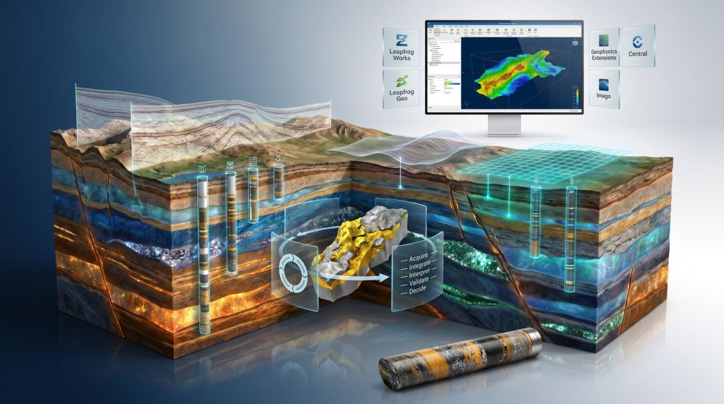
The Core Product Ecosystem: What Each Platform Does
Understanding Seequent's capabilities requires appreciating how its individual products interact within a broader subsurface intelligence framework.
| Product | Primary Function | Key Application Sector |
|---|---|---|
| Leapfrog Works | 3D subsurface visualisation and site investigation interpretation | Geotechnical and civil engineering |
| Leapfrog Geo | Geological modelling from exploration drilling and assay data | Mining and mineral resources |
| Geophysics Extensions | GPR, seismic, and EM data integration within 3D models | Multi-sector subsurface imaging |
| Central (Geodata Management) | Collaborative data sharing and model version control | Enterprise-scale operations |
| Imago | Digital core imaging and geospatial data capture | Exploration and core logging |
Each platform addresses a specific phase of the subsurface investigation lifecycle, but they are designed to operate as an integrated ecosystem rather than as isolated tools. The connective tissue between them is Seequent's Central geodata management platform, which provides version-controlled, audit-trailed access to subsurface models across multidisciplinary project teams.
How Geophysics Integration Works Inside Leapfrog
The Geophysics Extensions for Leapfrog Works represent one of the more technically sophisticated aspects of Seequent subsurface imaging systems, and one of the least understood outside specialist practitioner communities. Downhole geophysics, for instance, becomes considerably more powerful when its outputs are rendered directly within a live 3D modelling environment rather than processed in isolation.
When a GPR survey is conducted over a construction site or mine bench, the acquisition hardware generates a processed reflectivity dataset, typically in the form of a grid of two-dimensional profiles or a three-dimensional voxel volume. Historically, that dataset would be interpreted in isolation by a geophysicist using dedicated signal processing software, and the interpreted results would then be communicated to geotechnical engineers through reports and cross-sections, losing much of their spatial precision in translation.
Within Leapfrog Works' Geophysics Extensions, the processed geophysical dataset is instead imported directly into the 3D modelling environment, georeferenced to real-world coordinates, and rendered alongside existing borehole logs, laboratory-derived geotechnical parameters, and structural geological mapping. The geophysicist and geotechnical engineer are effectively working within the same interpretive space simultaneously.
This co-rendering capability allows practitioners to:
- Cross-correlate GPR reflectivity anomalies directly with borehole intercepts at the same three-dimensional coordinates
- Identify geophysical signatures that correspond to known geotechnical units, then extrapolate those signatures into areas between boreholes
- Drape electromagnetic anomaly grids over digital terrain models and correlate them with surface mapping observations
- Update the interpreted subsurface model in near real time as new field data arrives
The result is a continuously refined subsurface image that evolves through the project lifecycle rather than being frozen at a particular point in investigation.
Geodata Management: The Overlooked Foundation of Subsurface Integrity
The technical sophistication of 3D modelling and geophysics integration tools is only as valuable as the data management infrastructure supporting them. This is an insight that is frequently underestimated outside practitioner communities but is recognised as fundamental by experienced geotechnical teams at major mining operations.
Seequent's Central platform addresses this through several capabilities that are individually straightforward but collectively transformative:
- Version control: Every iteration of a subsurface model is preserved, allowing teams to trace how interpretations evolved as new data was acquired
- Audit trails: All modifications to the model are logged against the user who made them and the data that prompted the change
- Access controls: Different team members can be granted appropriate levels of read or edit access to subsurface models
- Collaborative model sharing: Multiple disciplines can work from the same authoritative model simultaneously, eliminating the risk of parallel, divergent interpretations developing independently
In large-scale mining operations where geotechnical models directly inform pit slope stability assessments, infrastructure placement decisions, and extraction sequencing, these governance capabilities are not administrative conveniences. They are risk management tools.
Real-World Applications: Where the Technology Demonstrates Measurable Value
Anglo American's Barro Alto Operation
Anglo American's Barro Alto ferronickel operation in Goiás, Brazil, provides a concrete illustration of the challenges that integrated subsurface modelling platforms are designed to solve. Barro Alto processes saprolite and limonite ores derived from deeply weathered ultramafic rocks, a geological setting characterised by extreme variability in weathering profiles, clay mineralogy, and geotechnical properties across short distances.
Geotechnical work at operations in comparable geological settings has historically relied on correlating data from multiple sources manually, a process prone to inconsistency and lag. The lateritic weathering profile at nickel operations like Barro Alto can transition from competent saprolite with reasonable engineering properties to soft limonite with very low bearing capacity over vertical intervals of just a few metres, creating significant geotechnical complexity for infrastructure design and pit slope management.
Integrated 3D geological modelling platforms enable geotechnical teams at operations of this type to consolidate borehole data, cone penetration test (CPT) profiles, and geophysical survey results into a single, continuously updated three-dimensional model. The operational benefit extends beyond efficiency: faster identification of geotechnical hazard zones, reduced uncertainty in ground support design, and improved confidence in infrastructure foundation assessments across the operation's footprint.
OceanaGold: Adaptive Modelling in Structurally Complex Gold Terrain
Gold mining operations in structurally complex terrains present a different category of subsurface intelligence challenge. Where nickel laterite operations contend primarily with vertical variability in weathering profiles, structurally controlled gold deposits demand precise three-dimensional understanding of fault networks, shear zones, and vein systems that can vary dramatically in orientation and continuity over short distances.
OceanaGold's operational experience with Seequent platforms illustrates how adaptive geological modelling supports mine planning in these environments. The ability to update ore body interpretations in near real time as new infill drilling results are received allows mine geologists to refine resource estimates without interrupting active production planning workflows.
Critically, this real-time model updating capability also supports a more responsive approach to geotechnical risk management in underground environments, where structural controls on rock mass behaviour are closely tied to the same geological architecture that determines ore grade distribution.
Civil Infrastructure and Transportation Corridors
Beyond the mining sector, Seequent subsurface imaging systems find significant application in transportation corridor planning, tunnelling, and foundation engineering for major infrastructure projects. In these contexts, Leapfrog Works enables site investigation data from multiple geotechnical test types to be unified within a single 3D model.
Relevant data types for civil infrastructure applications include:
- Cone penetration test (CPT) profiles, which provide continuous records of soil strength and stratigraphy
- Standard penetration test (SPT) results, widely used in foundation design assessments
- Laboratory-derived parameters including shear strength, consolidation characteristics, and permeability
- Geophysical survey datasets including seismic refraction profiles and electrical resistivity tomography (ERT) grids
- Historical records of buried utilities, legacy contamination zones, and previous construction activities
Integrating all of these inputs within a shared 3D environment supports risk-informed design decisions at a level of spatial precision that sequential, report-based communication between specialists cannot match.
Seequent vs. GPR Hardware Vendors: Understanding the Complementary Relationship
The framing of Seequent as competing with GPR hardware manufacturers represents a fundamental misunderstanding of how subsurface investigation value chains are structured. The two categories of technology operate at different points in the information lifecycle and are most powerful when deployed together.
| Dimension | Seequent (Software Platform) | GPR Hardware Vendors |
|---|---|---|
| Core function | 3D modelling, visualisation, and data integration | Physical signal transmission and reflection capture |
| Data output | Interpreted geological and geotechnical models | Raw 2D or 3D reflectivity profiles |
| User profile | Geologists, geotechnical engineers, mine planners | Field survey technicians, utility locators |
| Integration capability | Imports GPR, seismic, EM, borehole, and laboratory data | Standalone acquisition systems |
| Decision support | Direct link to engineering and planning workflows | Requires external interpretation software |
| Scalability | Enterprise-scale, multi-site, cloud-connected | Site-specific, project-level deployment |
The full subsurface imaging value chain runs from signal acquisition through to engineering decision support. GPR hardware occupies the acquisition end of that chain, while Seequent platforms occupy the interpretation and decision support end. Organisations that invest heavily in field acquisition tools without investing equivalently in interpretive platforms are effectively leaving a significant portion of the information value embedded in their field datasets unrealised.
The next major ASX story will hit our subscribers first
The Adaptive Engineering Framework: A Structured Approach to Subsurface Uncertainty
The concept of adaptive engineering, as demonstrated through Seequent platform case studies, represents a departure from the traditional project delivery model in which site investigation is treated as a front-loaded activity that produces a static set of baseline conditions for engineering design.
In an adaptive engineering framework, the subsurface model is treated as a continuously updated asset throughout the project lifecycle:
- Acquire – Collect geophysical, borehole, and geotechnical field data through systematic site investigation programmes
- Integrate – Import all data streams into a unified 3D modelling environment with full georeferencing and metadata preservation
- Interpret – Generate and refine subsurface models using geostatistical interpolation, implicit modelling, and geophysical co-rendering tools
- Validate – Cross-check model predictions against new field observations and laboratory test results as they become available
- Update – Continuously revise the subsurface model in response to new data, with full version control and audit trail documentation
- Decide – Use the current, validated model as the authoritative basis for engineering, planning, and risk management decisions
This cycle does not terminate at project completion. At operational mining sites, the adaptive engineering cycle continues through the production phase, with blast monitoring data, slope movement observations, and hydrogeological monitoring inputs feeding back into the geotechnical model throughout the mine's operating life.
The Technology Horizon: Where Subsurface Intelligence Is Heading
Several converging technological developments are reshaping the capabilities of platforms like Seequent's over the next decade.
Machine learning-assisted geological interpretation is beginning to reduce the manual effort required for lithological classification from downhole geophysical logs and digital core imagery. Furthermore, AI in mineral exploration is accelerating this transition by enabling systems trained on large libraries of annotated core photographs to identify mineralogical and textural boundaries with increasing accuracy, significantly speeding up the logging workflow at exploration drill programmes.
Digital twin integration is extending the scope of subsurface intelligence beyond the ground model itself. Subsurface geological and geotechnical models are increasingly being linked to surface infrastructure digital twins, creating end-to-end asset intelligence frameworks that allow operators to simulate the effects of proposed design changes on both surface structures and subsurface stability conditions simultaneously.
Real-time sensor data fusion represents perhaps the most operationally significant near-term development. The integration of in-situ monitoring data from piezometers, inclinometers, and extensometers directly into 3D geological models enables dynamic tracking of ground behaviour in response to mining-induced stress changes, rainfall events, or construction activities. This moves subsurface intelligence from a periodic interpretive exercise into a continuous operational monitoring capability.
Cloud-native geodata platforms are completing the transition from desktop-bound modelling workflows to browser-accessible, collaborative environments. Consequently, data-driven mining operations are becoming the norm, with subsurface models now accessible and interrogable by project stakeholders regardless of geographic location.
The convergence of these capabilities is progressively dissolving the traditional boundaries between geophysical imaging, geotechnical characterisation, and data science. Practitioners who can operate fluently across all three domains will define the standard of subsurface intelligence practice for the generation of mining and infrastructure projects now entering the development pipeline.
Key Reference Summary: Seequent Subsurface Imaging Systems at a Glance
| Dimension | Summary |
|---|---|
| Platform type | Geoscience software, not hardware |
| Core capability | 3D geological modelling, geophysics integration, geodata management |
| Key products | Leapfrog Works, Leapfrog Geo, Geophysics Extensions, Central, Imago |
| Primary sectors | Mining, civil infrastructure, geothermal, groundwater, environmental |
| Geophysical data supported | GPR, seismic reflection, EM surveys |
| Strategic framework | Adaptive engineering through continuous model updating |
| Competitive position | Subsurface interpretation layer, complementary to GPR and seismic hardware vendors |
Disclaimer: This article is intended for informational and educational purposes only. It does not constitute financial, investment, or professional engineering advice. Readers should conduct their own due diligence and consult qualified professionals before making decisions based on the information presented here. Case study references reflect publicly available industry reporting and should not be interpreted as endorsements by the companies named.
Want to Stay Ahead of the Next Major ASX Mineral Discovery?
Discovery Alert's proprietary Discovery IQ model delivers real-time alerts the moment significant ASX mineral discoveries are announced, transforming complex geological data into actionable investment insights for both short-term traders and long-term investors — explore historic discovery returns on Discovery Alert's dedicated discoveries page to understand the magnitude of opportunity, then begin your 14-day free trial to position yourself ahead of the broader market.