August 21, 2026
When Mountains Redirect Rivers: The Geomorphology of Ice-Age Drainage Reorganisation
Few geological processes reshape continental landscapes as dramatically as glacially driven drainage reorganisation. While most people associate the Ice Ages with frozen tundra and woolly mammoths, one of the most underappreciated consequences of Pleistocene glaciation was the wholesale rerouting of entire river systems. Across the world's mid-latitude mountain ranges, advancing ice sheets didn't just carve valleys and deposit moraines. They actively dismantled pre-existing drainage networks and rebuilt them according to entirely new rules. No landscape in the contiguous United States illustrates this principle more vividly than the North Cascades, where the Skagit River Gorge drainage capture stands as one of the most extraordinary examples of glacially induced river piracy ever documented in North America.
When big ASX news breaks, our subscribers know first
The Geological Stage: Understanding the North Cascades Crystalline Core
The North Cascades are structurally among the most complex mountain ranges on the continent. At their heart lies a crystalline core of intensely deformed metamorphic and igneous rocks, bounded by major fault systems that have defined the region's tectonic architecture for tens of millions of years. Furthermore, the mineralogy of ores and rock types found throughout this region reflects that extraordinary tectonic complexity.
Two fault systems are particularly significant for understanding how the Skagit Valley formed. The Ross Lake Fault Zone trends northward through the valley, intersecting with the Hozomeen Fault system to define a wedge-shaped geological unit known as the Hozomeen Group. This group is composed of three distinct rock types: greenstone, derived from weakly metamorphosed submarine basalt; schist; and radiolarian chert.
The radiolarian chert, sometimes called Hozomeen chert, holds geological and cultural significance in equal measure. Indigenous peoples quarried this stone for close to 10,000 years, creating one of the most enduring archaeological records in the Pacific Northwest — a timeline that itself reflects how fundamentally the drainage reorganisation event opened the valley to human access.
Against this structural backdrop, a single anomalous feature stands out to anyone who studies the regional hydrology: the Skagit River is the only waterway that cuts completely across the entire North Cascades geological grain. Every other drainage follows the structural grain of the mountains or terminates within the range. Understanding why requires stepping back into deep time and tracing the extraordinary sequence of events that produced what geologists now recognise as the Skagit River Gorge drainage capture.
Two Fundamentally Different Ice Regimes
What Is the Difference Between Alpine and Continental Glaciation?
A key concept for understanding what happened in this valley is the distinction between alpine glaciation and continental ice sheet glaciation. These are not simply different sizes of the same phenomenon. They behave differently, erode differently, and leave entirely different fingerprints on the landscape.
| Feature | Alpine Glaciation | Continental Ice Sheet |
|---|---|---|
| Ice thickness | ~500 to 1,000 m in valleys | Exceeded 2,000 m at peak |
| Source area | Local mountain peaks and cirques | Canadian interior plateaus |
| Landform signature | U-shaped valleys, cirques, aretes | Rounded ridgelines, striations, erratics |
| Timing relative to each other | Peaked earlier, retreated first | Arrived later, persisted longer at valley level |
| Scale difference | Order of magnitude thinner | Dominant erosive force at landscape scale |
In the North Cascades, these two regimes operated largely out of phase with each other during the last glacial cycle. The global Last Glacial Maximum occurred approximately 21,000 years ago, when alpine glaciers in the North Cascades were at or near their peak extent. Yet the Cordilleran Ice Sheet, advancing southward from Canada, did not reach its local maximum in this region until approximately 16,000 years ago. This means that for roughly 5,000 years, the continental ice sheet was advancing into valleys that the alpine glaciers were already vacating.
This timing gap has a striking explanation: the advancing ice sheet was so climatically dominant that it effectively starved the surrounding alpine glaciers of precipitation, causing them to retreat up into the mountains even as continental ice pushed southward. The practical result was that the major valley floors were largely open and unoccupied by local ice when the ice sheet arrived, making them perfect conduits for the advancing continental mass.
The topographic asymmetry of Ross Lake reflects this climatic complexity in vivid terms. On the west side of the valley, large U-shaped valleys — including Big Beaver, Little Beaver, and Arctic Creek — indicate that substantial alpine glaciers once occupied them, carving the characteristic broad, flat-floored troughs. On the east side, rivers enter through narrow V-shaped canyons, reflecting far smaller glaciers or none at all. The reason is purely climatic: annual precipitation drops from approximately 84 inches at Marblemount to roughly 30 inches near Hozomeen, a rain shadow gradient that directly controlled glacier size and, consequently, valley shape across the entire drainage system.
Reconstructing the Pre-Glacial Drainage Divide
Before the Pleistocene, the drainage architecture of what is now the upper Skagit watershed looked entirely different. Where the Skagit Gorge now cuts westward through the range, there was once a mountain pass — a bedrock divide that separated northward-draining streams feeding the ancestral Fraser River system from westward-draining streams heading toward Puget Sound. In addition, understanding the geological significance of the Chumstick Basin helps place such regional drainage histories in their broader tectonic context.
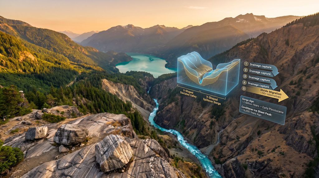
Thermochronometric dating, which tracks the thermal history of rocks as they approach Earth's surface through erosional unroofing, suggests that the Skagit River Gorge is younger than approximately 2 million years, placing its formation in the early Pleistocene. For a feature surrounded by mountains with a geological history stretching back hundreds of millions of years, this makes the gorge itself an anomalously young landform.
Thermochronometric evidence suggests the Skagit Gorge is less than 2 million years old, making it geologically young relative to the ancient crystalline rocks that surround it on all sides.
Prior to the gorge's formation, Thunder Creek may have drained northward and ultimately contributed to a system connected to the ancestral Mackenzie River. The idea that what is now the upper Skagit watershed was once part of an entirely different continental drainage regime — one oriented toward the Arctic rather than the Pacific — is one of the more conceptually vertiginous ideas in regional geology. Consequently, supercontinent cycles in geology remind us that such large-scale drainage reorganisations are not isolated events but part of Earth's ongoing tectonic story.
The Skagit River Gorge Drainage Capture Mechanism: A Step-by-Step Reconstruction
The formation of the Skagit River Gorge drainage capture can be traced through five sequential stages, each building on the last through a self-reinforcing feedback process.
Stage 1: The Cordilleran Ice Sheet Blocks Northward Drainage
The continental ice sheet, building up on the plateaus of interior British Columbia, began advancing southward across the North Cascades. Rivers draining northward through this terrain — including the upper Skagit, Similkameen, Pasayten, and Ashnola — were progressively blocked by advancing ice. At its peak, the ice sheet was likely more than a mile thick in places, overtopping ridgelines like Sourdough Ridge and reshaping their profiles into the rounded, ice-smoothed forms visible today.
Stage 2: A Proglacial Lake Builds Behind the Ice Barrier
With northward drainage blocked, water began to pond in the upper Skagit valley. The ice sheet was sufficiently thick that subglacial escape was not possible, so lake levels rose progressively. This was not a minor pool but a substantial glacially dammed lake occupying a significant portion of the valley. The Skagit River watershed's geologic evolution provides valuable context for understanding how this proglacial system developed over time.
Stage 3: Spillover Across the Lowest Available Pass
As the proglacial lake rose, it eventually reached the lowest topographic threshold in the watershed. That threshold corresponded to the location of the present-day Skagit Gorge. Water began spilling westward across the bedrock divide. Critically, this was a spillover event, not a catastrophic ice-dam outburst. The distinction matters enormously for understanding the erosional process that followed.
Geologists distinguish carefully between spillover floods, where a proglacial lake gradually overtops a bedrock pass and erodes it progressively, and outburst floods, where an ice dam fails suddenly and catastrophically. The Skagit Gorge is primarily attributed to sustained spillover erosion, though glacially pressurised subglacial water may also have contributed.
Stage 4: Positive Feedback and Divide Migration
Once spillover began, the process became self-amplifying. Erosion deepened the outlet channel, which lowered the lake level slightly, which increased the hydraulic gradient, which accelerated erosion. This headward erosion progressively consumed the bedrock divide, migrating it upstream toward the ponded lake. The divide migrated an estimated 50 or more kilometres, making it one of the largest documented divide migration events in the North Cascades region by a significant margin.
Stage 5: Permanent Capture of the Upper Skagit Drainage
The upper Skagit watershed was permanently rerouted into the lower Skagit system. The gorge became the dominant conduit not only for the reorganised river but for subsequent glacial meltwater floods as the ice sheet retreated northward. Multiple spillover events from other valleys — including the Similkameen and even, temporarily, a portion of the Fraser River itself — contributed discharge through this corridor during deglaciation.
Regional Comparison: How the Skagit Event Ranks Among North Cascades Divide Migrations
Evidence for proglacial lake spillovers has been documented at approximately 12 sites across the North Cascades divide. These events varied enormously in scale, as the following comparison illustrates.
| Location | Estimated Divide Migration | Mechanism |
|---|---|---|
| Skagit Gorge | 50+ kilometres | Proglacial lake spillover, sustained erosion |
| Lost River / Pasayten | ~15 kilometres | Lake spillover and headward erosion |
| Other North Cascades sites | 50 metres to several kilometres | Variable spillover events |
The Skagit event represents the extreme end of this regional spectrum. For context, other divide migration events in the region involved distances two orders of magnitude smaller. The combination of a large proglacial lake, a relatively low bedrock threshold, and a well-positioned downstream valley capable of accepting the rerouted drainage made the Skagit location uniquely susceptible to this scale of reorganisation.
The Skagit Gorge also draws comparison to the Columbia River Gorge as one of the few range-transverse canyons in the Cascades — a river that cuts directly across the structural grain of a major mountain range rather than following it.
The next major ASX story will hit our subscribers first
What the Bedrock Benches Visible from Diablo Lake Overlook Actually Represent
One of the most geologically revealing vantage points in the entire North Cascades is the Diablo Lake Overlook, where a series of stripped bedrock benches flank the gorge on both sides. These benches are not random erosional remnants. They are the surviving fragments of the former mountain pass — the divide that once separated the northward and westward drainage systems.
The gorge itself displays a distinctive cross-sectional profile: a V-shaped inner canyon incised into the floor of a much broader U-shaped glaciated valley. The U-shape records the deep alpine and continental glacial erosion that widened and deepened the valley over multiple glacial cycles. The V-notch records the subsequent fluvial and spillover incision that created the gorge. This nested geometry is a direct physical signature of the two different processes operating at different scales and times.
The bedrock benches have survived partial preservation in part because of the geometry of ice flow near Jack Mountain. The continental ice sheet, streaming from northeast to southwest across Ross Lake, made an angular turn as it entered the gorge section. This turn likely reduced the erosive efficiency of the ice at the bench locations, allowing remnants of the former divide to persist rather than being completely consumed.
Biological Confirmation: Bull Trout Genetics as a Glacial Flood Record
Perhaps the most unexpected line of evidence supporting the Skagit River Gorge drainage capture story comes not from geology but from biology. At the end of the last ice age, when the Cordilleran Ice Sheet blocked the Fraser River and caused it to temporarily discharge southward through the Skagit Valley, the floodwaters carried bull trout from the Fraser drainage into the upper Skagit system. Furthermore, research into fluvial geomorphology confirms that such biological transfers during glacial drainage reorganisation are well documented across similar systems worldwide.
When the ice retreated and normal drainage was restored, those bull trout were isolated in the upper Skagit. Today, they are genetically distinguishable from bull trout populations in the lower Skagit Valley — a biological signature of a glacial flood event that occurred roughly 14,000 to 16,000 years ago. This independent biological evidence corroborates what the sedimentary and geomorphic record suggests, providing cross-disciplinary confirmation of the entire drainage reorganisation sequence.
A Composite Landscape Built Over Millions of Years
A critical point for understanding the North Cascades landscape is that it is not the product of a single glaciation. Geologists estimate that as many as two dozen glacial cycles have occurred over the past 2.5 million years, each alternating between alpine and continental ice regimes. The topography visible today is a cumulative record of all of them, with the most recent glaciation simply providing the last layer of modification.
The concept of the glacial buzzsaw, popularised in geomorphological literature, describes how repeated glaciation progressively lowers summit elevations and deepens valley floors. In the North Cascades, this process has operated across roughly 2.5 million years and dozens of glacial cycles.
Most of the valley shaping in the Skagit drainage was accomplished by alpine glaciers rather than the continental ice sheet, because alpine glaciers spent far more cumulative time in these valleys across all the glacial cycles combined. The ice sheet, though far thicker and more powerful when present, visited these valleys for comparatively brief intervals and departed relatively quickly. However, metamorphism and mineral formation throughout this region also bears the imprint of these repeated cycles of pressure, heat, and erosional unroofing.
Frequently Asked Questions About the Skagit River Gorge
What caused the Skagit River Gorge to form?
The gorge formed primarily through a proglacial lake spillover event triggered by the Cordilleran Ice Sheet blocking northward drainage in the upper Skagit watershed. Rising lake levels eventually overtopped the lowest bedrock divide, initiating sustained erosional incision and progressive divide migration.
Was the Skagit Gorge formed by a single catastrophic flood?
No. The primary mechanism was a sustained spillover process rather than a single catastrophic outburst. While glacial floods contributed to gorge modification, the fundamental capture event involved progressive erosion over an extended period, beginning in the early Pleistocene.
How old is the Skagit River Gorge?
Thermochronometric dating suggests the gorge formed within approximately the last 2 million years, placing its origin in the early Pleistocene. This makes it geologically young relative to the ancient crystalline rocks surrounding it.
Did the upper Skagit River once flow into the Fraser River?
Prior to drainage capture, the upper Skagit likely drained northward, with geological evidence suggesting a former connection to the Fraser and potentially to the ancestral Mackenzie River system via Thunder Creek.
What do the bedrock benches at Diablo Lake Overlook represent?
These benches are remnants of the former mountain pass that once served as the drainage divide. They have survived partial erosion due to the geometry of ice flow near Jack Mountain, which reduced the efficiency of glacial erosion at those specific locations.
Why the Skagit Gorge Remains One of North America's Most Significant Glacial Landforms
The Skagit River Gorge drainage capture is significant not just as a regional curiosity but as a window into the mechanics of large-scale landscape reorganisation under continental glaciation. It demonstrates how a single, sustained spillover event — amplified by positive erosional feedback — can permanently redirect an entire regional drainage system across distances measured in tens of kilometres.
It shows how biological, sedimentary, geomorphic, and thermochronometric lines of evidence can converge to reconstruct events that occurred before any human observation. And it reveals how the interplay between alpine and continental ice regimes, operating out of phase across multiple glacial cycles, produces landscapes of extraordinary complexity that no single glaciation could explain alone. Indeed, understanding such events enriches our broader knowledge of the global mining landscape and how ancient geological processes shape the mineral endowments we work with today.
Ongoing research continues to refine the timing and sequence of proglacial lake formation and drainage across the North Cascades crest, with the sedimentary deposits at Ross Lake and the alluvial fan at Lightning Creek representing important but not yet fully documented archives of these events.
Want to Discover the Next Major Mineral Find Before the Broader Market Does?
The geological processes that shaped ancient landscapes like the North Cascades ultimately gave rise to the mineral endowments driving today's resource discoveries — and Discovery Alert's proprietary Discovery IQ model ensures subscribers receive real-time alerts the moment significant ASX mineral discoveries are announced, turning complex data into actionable investment insights. Explore historic discoveries and their remarkable returns, then begin your 14-day free trial to position yourself ahead of the market.