May 20, 2026
The Measurement Gap That Modern Drilling Can No Longer Afford to Ignore
Every wellbore drilled into a complex reservoir is, at some fundamental level, a navigation problem. The drill bit advances through kilometres of subsurface rock, guided by measurements that, until recently, could only confirm what the bit had already passed through. In thin-bed carbonates, structurally folded sequences, and low-resistivity shale interbeds, that retrospective view is often too late. By the time conventional sensors confirm a formation boundary has been crossed, the wellbore is already off-target, and the cost of correction compounds rapidly.
This is the operational reality that has driven the development of next-generation look-ahead measurement systems. The SLB AlphaSight geosteering tool represents one of the most technically ambitious responses to that challenge, integrating multi-depth resistivity measurement with downhole computing to push reservoir visibility further ahead of the bit than conventional logging-while-drilling configurations have historically allowed.
Understanding why this matters requires examining the specific failure modes of traditional resistivity tools, the physics of what the new measurement architecture achieves, and how that translates into tangible drilling performance improvements across diverse global basin environments.
When big ASX news breaks, our subscribers know first
Why Conventional LWD Resistivity Falls Short in Complex Reservoir Environments
Logging-while-drilling resistivity tools have been a fixture of directional well programs for decades. They measure the electrical properties of surrounding formations while the drill string is in motion, providing continuous formation evaluation without the cost and time of a dedicated wireline logging run. For straightforward reservoir targets with clear structural geometry and high resistivity contrast, they perform reliably.
The problem emerges in complexity. When operators target thin-bed carbonates, for instance, the pay zone may span only a few feet vertically. A conventional resistivity tool with limited depth of investigation can only confirm formation contact after the bit is already within or past the target interval. In that scenario, any trajectory correction is reactive rather than anticipatory, and the wellbore may already require a sidetrack to recover optimal reservoir placement.
Low-resistivity shale sequences introduce a different complication. Resistivity contrast between the pay zone and surrounding shale may be minimal, reducing the tool's ability to differentiate boundaries clearly until the bit is already at or past the transition. Combined with structural complexity such as faults, dip changes, or stratigraphic pinchouts, the result is a compounding uncertainty that increases the risk of suboptimal wellbore placement.
The broader industry consequence of these limitations includes:
- Increased nonproductive time (NPT) associated with unplanned sidetracks in complex formations
- Reduced reservoir contact in extended-reach lateral sections where well placement drifts outside the target window
- Greater reliance on pre-drill geological models that may not accurately represent actual subsurface conditions
- Higher per-well capital costs when reactive trajectory corrections are required mid-lateral
The progression toward targeting increasingly thin and structurally complex pay zones has widened the performance gap between what conventional resistivity tools can deliver and what modern geosteering programs genuinely require. Furthermore, downhole geophysics continues to evolve in response to these limitations, pushing the boundaries of what is measurable in real time.
Extended-Reach and High-Angle Wells: Where Measurement Limitations Become Economically Critical
Extended-reach drilling (ERD) programs amplify every limitation of conventional LWD resistivity geometry. In a well drilled at high angle or near-horizontal orientation across a kilometre-scale lateral section, even a modest vertical drift in wellbore position compounds across the entire lateral length. A tool that detects a formation boundary only after it has been crossed provides little operational value when the consequence is hundreds of metres of misplaced wellbore.
Formation heterogeneity along a long lateral also tends to be higher than pre-drill models predict. Stratigraphic variability, local structural dip changes, and facies transitions all create unexpected formation boundary encounters that a look-ahead measurement capability is specifically designed to address. Rather than responding after boundary contact, a system that detects formation geometry ahead of the bit allows the directional drilling team to adjust trajectory proactively, maintaining reservoir position through variable geology without interrupting drilling operations.
The industry's shift toward longer laterals and thinner pay zone targets has effectively redefined the minimum acceptable depth of investigation for a geosteering-grade resistivity tool. What was sufficient for simpler reservoir geometries a decade ago no longer meets the precision requirements of modern well programs.
This is the operational context into which the SLB AlphaSight geosteering tool was introduced. In addition, the growing complexity of drilling programs across global basins has made the case for advanced look-ahead capability more compelling than ever.
What the SLB AlphaSight System Is and How It Works
The AlphaSight system is classified as a reservoir mapping platform that integrates multi-depth resistivity measurements with embedded downhole computing capability. Its primary function is to extend the range and resolution of formation data available to drilling teams in real time, providing earlier and clearer insight into subsurface structure ahead of the advancing drill bit.
The architecture differs from conventional LWD resistivity tools in several meaningful ways. Where standard tools provide a single or limited set of investigation depths focused primarily on the formation immediately surrounding the wellbore, AlphaSight's multi-depth configuration extends radial investigation range simultaneously across multiple depths of investigation. This allows the system to construct a more complete picture of formation geometry, including structural features and boundary positions that lie beyond the borehole wall at distances relevant to geosteering trajectory planning.
The integration of downhole computing is a critical enabler of the system's real-time performance. By processing measurement data at the tool level rather than transmitting raw signals to the surface for processing, the system reduces the latency between data acquisition and actionable formation information. For a drilling team making trajectory decisions in real time, that reduction in interpretation cycle time has direct operational value.
The Multi-Depth Azimuthal Measurement Principle
Azimuthal resistivity measurement refers to the tool's ability to distinguish formation properties in different directional orientations around the wellbore axis, rather than averaging properties radially. In a high-angle or horizontal well, this directional sensitivity allows the system to differentiate resistivity characteristics above and below the wellbore, identifying approaching formation boundaries with spatial resolution that non-azimuthal tools cannot achieve.
Multi-depth azimuthal resistivity (MDAR) extends this principle by simultaneously acquiring measurements at different radial investigation distances from the borehole. Shallow investigation depths capture near-wellbore formation detail, while deeper investigation depths provide structural context at distances relevant to look-ahead trajectory planning. Together, these measurement layers create a formation image with both near-bit precision and extended-range structural awareness.
Triaxial Collocated Antenna Architecture
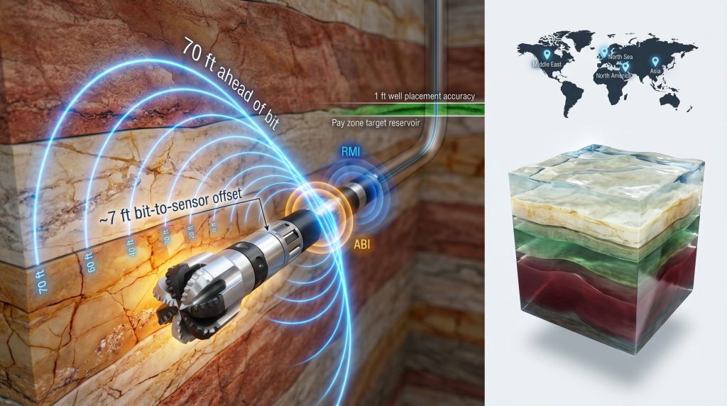
A defining hardware characteristic of the AlphaSight system is its triaxial collocated antenna design, positioned near the drill bit. In conventional spaced-antenna configurations, transmitter and receiver antennas are separated along the tool body, introducing a physical offset between the measurement point and the bit location. This offset means the formation data acquired reflects conditions at a point behind the bit, not at the current drilling face.
Collocating triaxial antennas near the bit reduces this measurement offset to approximately 7 feet, a class-leading specification in the current market. The practical effect is that the formation data acquired is geometrically much closer to the actual drilling point, improving the relevance and accuracy of real-time formation evaluation for geosteering decisions. The triaxial configuration captures measurement sensitivity in three orthogonal directions, enhancing both vertical and horizontal resolution while reducing the geometric uncertainty inherent in spaced, single-axis designs.
The extended look-ahead range achieved by the MDAR platform reaches up to 70 feet ahead of the bit, approximately double the depth of detection provided by conventional LWD resistivity tools. This extended forward visibility is the operational foundation of AlphaSight's geosteering value proposition.
| Feature | Conventional LWD Resistivity | SLB AlphaSight |
|---|---|---|
| Depth of Detection | Standard range | Up to 70 ft ahead of bit |
| Antenna Configuration | Spaced, single-axis | Triaxial collocated, near-bit |
| Look-Ahead Capability | Limited or absent | True horizontal look-ahead |
| Bit-to-Sensor Offset | Typically greater than 10 ft | Approximately 7 ft |
| Inversion Capability | Single-mode | Dual-mode: RMI + ABI |
| Integration | Standalone LWD | Integrated with RSS |
Dual Inversion Architecture: Strategic Mapping and Tactical Boundary Detection
One of the more technically sophisticated aspects of AlphaSight is its dual inversion engine, which addresses two distinct but equally important operational needs within a single integrated toolstring.
Reservoir Mapping Inversion (RMI) operates on the deeper investigation measurement data to construct formation geometry models from multi-depth resistivity inputs. This mode provides the structural context that geosteering teams need for longer-range trajectory planning, identifying formation dip, layer thickness, and stratigraphic architecture at distances relevant to well path optimisation decisions made tens of feet ahead of current bit position.
At-Bit Inversion (ABI) applies a different processing methodology to the near-bit measurement data, functioning as a proximity detection engine. It provides real-time alerts when the wellbore approaches a formation boundary, giving the directional drilling team immediate warning of an impending boundary encounter before bit contact occurs.
Running both inversion modes simultaneously means the tool is continuously answering two different but complementary questions: where is the formation going over the next 70 feet, and how close is the nearest boundary right now? That dual awareness architecture is what separates reservoir mapping services from conventional LWD resistivity tools.
The parallel operation of RMI and ABI within a single run eliminates the traditional trade-off between strategic formation context and tactical boundary awareness, both of which are necessary for consistently precise wellbore placement in complex reservoir environments.
Rate of Penetration Compatibility: Eliminating the Data-Speed Trade-Off
A persistent operational tension in advanced LWD tool design is the relationship between measurement quality and drilling speed. More sophisticated sensors and processing architectures can impose rate-of-penetration (ROP) penalties if the tool requires slower drilling to acquire sufficient data for reliable inversion. In commercial drilling operations, where ROP directly affects well cost and schedule, any tool-imposed ROP constraint is a significant limitation.
AlphaSight is specifically engineered to maintain full measurement performance without imposing ROP penalties. Drilling teams can operate at commercial drilling speeds while simultaneously accessing the enhanced formation data the system provides. This compatibility is not incidental but reflects a deliberate design priority, recognising that a technically advanced tool with an operational speed limitation will face adoption resistance regardless of its measurement capability.
The practical consequence is that AlphaSight integrates into existing well programmes without requiring operational modifications to drilling parameters, making the technology accessible across a broader range of well types and operating environments.
The next major ASX story will hit our subscribers first
Where AlphaSight Delivers the Greatest Operational Value
The combination of extended look-ahead range, near-bit azimuthal sensitivity, and dual inversion capability makes AlphaSight applicable across a range of drilling scenarios where conventional resistivity tools underperform. The following matrix summarises the primary application environments and the specific system capabilities most relevant to each:
| Drilling Scenario | Primary AlphaSight Capability |
|---|---|
| Thin-bed carbonate navigation | Multi-depth structural imaging + ABI boundary detection |
| Offshore directional drilling | Extended look-ahead + RSS integration |
| Deepwater reservoir mapping | 3D MDAR formation characterisation |
| High-angle well placement | Azimuthal resolution + near-bit sensitivity |
| Low-resistivity shale mapping | Enhanced measurement sensitivity + RMI |
| Relief well engineering | Precise wellbore proximity detection |
| Extended-reach drilling | Long-range look-ahead + ROP-compatible operation |
Each of these scenarios shares a common characteristic: the cost of reactive trajectory correction significantly exceeds the cost of proactive formation awareness. AlphaSight's value proposition is fundamentally about shifting the geosteering decision point earlier in the drilling process, when correction is cheaper and less disruptive.
Field Performance Across Global Basin Deployments
Kuwait Onshore Carbonate: Sub-1-Foot Placement Precision
One of the most technically demanding documented applications of AlphaSight involved a layered carbonate formation in Kuwait, where the combination of complex stratigraphy and narrow reservoir windows created a wellbore placement challenge that conventional resistivity guidance had historically struggled to resolve without sidetracks.
In this deployment, AlphaSight's extended look-ahead and dual inversion capability enabled the drilling team to maintain wellbore position within 1 foot of the reservoir top across the full lateral section. No sidetracks were required, representing a measurable step-change in placement precision relative to conventional resistivity-guided approaches in comparable carbonate environments. Consequently, in a formation type where thin pay zones and stratigraphic variability routinely drive costly wellbore corrections, this outcome demonstrates the system's practical capability in one of its most technically challenging application environments.
Offshore Structural Heterogeneity: Multi-Unit Stratigraphic Resolution
In an offshore multi-stratigraphic sequence characterised by pinchout features and structural discontinuities across multiple stratigraphic units, AlphaSight was deployed to evaluate formation architecture that would have required multiple dedicated evaluation runs under conventional methodologies.
The system successfully identified pinchout features and structural heterogeneities across multiple stratigraphic units in a single run. For field development planning purposes, this single-run multi-unit mapping capability reduces evaluation well requirements, compressing the time and capital investment associated with appraisal phases in structurally complex offshore developments.
Multi-Basin Deployment Footprint
AlphaSight has been commercially deployed across four major global basin environments:
- Middle East: Carbonate-dominated reservoir systems with complex stratigraphy and high-value well programmes
- North Sea: Offshore mature field developments with structurally variable reservoir sequences
- North America: Diverse unconventional and conventional reservoir targets spanning multiple formation types
- Asia: Regional basin diversity spanning both onshore and offshore operating environments
Multi-basin deployment validation is a meaningful indicator of technology maturity. A system that performs reliably only in specific formation types or operating conditions has limited commercial applicability. The diversity of basin environments in which AlphaSight has been deployed and validated strengthens confidence in the measurement architecture's robustness across the full range of reservoir conditions operators encounter globally.
AlphaSight's Role in the Broader Digital Drilling Transformation
From Data Acquisition to Autonomous Well Delivery
The introduction of AlphaSight reflects a broader architectural shift in how the drilling industry thinks about subsurface data and its role in well delivery. Advanced real-time formation evaluation tools are increasingly being positioned not as standalone measurement services but as foundational components of digital drilling architectures that eventually support closed-loop and autonomous geosteering workflows.
When downhole computing enables formation inversion to occur at the tool level in real time, the data arriving at the surface is already interpreted, not raw. That shift from raw signal to interpreted formation geometry is a prerequisite for the kind of automated decision-making that closes the loop between measurement and trajectory adjustment without requiring human interpretation at every step. AlphaSight's embedded processing architecture is therefore directly aligned with the trajectory toward autonomous well delivery systems, a trend closely connected to broader advances in AI in drilling operations that the industry's leading operators are beginning to pursue in earnest.
The Economics of NPT Reduction Through Look-Ahead Capability
The economic case for advanced look-ahead resistivity technology is straightforward in principle, though the specific numbers vary significantly by well type, geography, and operating environment. Sidetracks in complex reservoir environments are among the most expensive reactive corrections available to a drilling team, involving additional drilling time, casing runs, cement operations, and in some cases, complete wellbore section abandonment.
Earlier formation detection reduces the frequency and magnitude of reactive trajectory corrections. When a formation boundary encounter is anticipated 70 feet ahead of bit contact, the drilling team has time to adjust inclination and azimuth gradually, maintaining smooth wellbore geometry and avoiding the steep corrections that increase mechanical risk and drilling complexity. The cumulative NPT reduction across a multi-well field development programme translates into meaningful capital efficiency improvements that justify the technology investment on purely economic grounds, independent of the reservoir contact quality benefits.
Petrophysical Intelligence as a Competitive Differentiator
Beyond NPT reduction, AlphaSight's enhanced petrophysical insight delivers a downstream production performance benefit that is sometimes underweighted in tool selection decisions. Wellbore placement that consistently maintains the drill bit within the optimal reservoir window translates into higher reservoir contact quality across the full lateral length. Higher reservoir contact quality, particularly in heterogeneous formations where pay distribution is uneven, correlates with improved production rates and recovery factors over the producing life of the well.
For operators managing multi-well development programmes in complex reservoirs, the cumulative production uplift from systematically improved wellbore placement is a financially material outcome, not merely a technical achievement. However, realising this downstream value requires accurate interpreting drill results alongside the real-time formation data the system provides. This downstream value dimension strengthens the economic case for advanced look-ahead geosteering services beyond the immediate drilling cost savings that NPT reduction represents.
Frequently Asked Questions: SLB AlphaSight Geosteering Technology
What makes AlphaSight different from standard LWD resistivity tools?
The system distinguishes itself through its triaxial collocated near-bit antenna design, dual inversion capability combining RMI and ABI modes, extended depth of detection reaching up to 70 feet ahead of the bit, and true horizontal look-ahead functionality. These capabilities are collectively absent from conventional LWD resistivity configurations, which rely on single-axis spaced antennas, limited investigation depth, and reactive boundary detection rather than proactive formation mapping.
How far ahead of the drill bit can AlphaSight detect formation features?
The system's extended MDAR measurement range enables formation detection up to 70 feet ahead of the bit, approximately double the depth of detection achievable with conventional LWD resistivity tools.
Does AlphaSight reduce drilling speed?
No. The system is specifically engineered to operate at full measurement performance without imposing rate-of-penetration penalties, allowing drilling teams to maintain commercial drilling speeds while accessing enhanced subsurface data continuously.
Which reservoir types benefit most from AlphaSight?
The technology delivers the greatest value in:
- Thin-bed carbonate sequences with narrow pay windows
- Low-resistivity shale formations with limited resistivity contrast
- Structurally complex offshore reservoirs with pinchout features and heterogeneous stratigraphy
- Extended-reach lateral sections where wellbore drift compounds over long distances
- Deepwater stratigraphic trap targets requiring high-precision placement
In which global regions has AlphaSight been commercially deployed?
Confirmed commercial deployments span the Middle East, North Sea, North America, and Asia, providing multi-basin field validation across diverse formation types and operating environments.
Key Technical and Operational Summary
| Parameter | Specification |
|---|---|
| System classification | 3D multi-depth azimuthal resistivity (MDAR) with RSS integration |
| Defining hardware innovation | Triaxial collocated near-bit antennas |
| Look-ahead detection range | Up to 70 ft ahead of the bit |
| Bit-to-sensor offset | Approximately 7 ft (class-leading) |
| Inversion architecture | Dual-mode: RMI (deep structural) + ABI (proximity detection) |
| ROP impact | None confirmed |
| Proven application environments | Carbonates, offshore stratigraphic sequences, low-resistivity shales, ERD wells, relief wells |
| Documented field result | Sub-1-ft placement accuracy in Kuwait onshore carbonate, zero sidetracks |
| Global deployment | Middle East, North Sea, North America, Asia |
| Strategic alignment | Digital drilling transformation, autonomous well delivery trajectory |
Furthermore, understanding true vs apparent widths remains an important consideration when evaluating subsurface measurement data from advanced geosteering systems such as this one.
Disclaimer: Technical specifications and field performance data referenced in this article are drawn from publicly available industry reporting. Specific performance claims, including look-ahead range, bit-to-sensor offset, and wellbore placement precision, reflect information reported through industry sources and have not been independently verified through third-party testing. Readers should consult SLB's formal technical documentation for authoritative specifications. This article does not constitute investment advice or endorsement of any specific technology or commercial service.
Want to Stay Ahead of the Next Major Mineral Discovery?
Just as advanced geosteering technology gives drilling teams a critical edge by detecting formations before the bit arrives, Discovery Alert's proprietary Discovery IQ model delivers real-time alerts the moment significant ASX mineral discoveries are announced — turning complex data into actionable investment insights before the broader market reacts. Explore historic discovery returns to understand the potential scale of these opportunities, and begin your 14-day free trial today to position yourself ahead of the market.