August 8, 2026
Reading the Earth From Above: What Sock Mountain Reveals About Deep Geologic Time
The moment you stand on a summit in the North Cascades, you are not simply looking at mountains. You are reading a geological archive spanning hundreds of millions of years, compressed into a landscape so complex that even seasoned geologists describe it as one of the most tectonically intricate mountain belts on the continent. Sock Mountain geology and glacial history, a subject that barely hints at the depth of what this summit makes visible, offers one of the most complete natural classrooms for understanding both the deep bedrock history of the region and the more recent, but equally dramatic, story of continental glaciation.
When big ASX news breaks, our subscribers know first
What Makes Sock Mountain Geologically Significant in the North Cascades?
Geographic Setting and Summit Perspectives
Sock Mountain sits within the northern Washington Cascade Range, positioned at approximately 5,000 feet in elevation. That figure, seemingly modest among the surrounding peaks, turns out to be geologically and glaciologically critical, as will become clear when the Cordilleran Ice Sheet enters the picture.
From the summit, the panoramic view encompasses a remarkable collection of landmarks:
- Jack Mountain, rising to over 9,000 feet and visible as a dramatic shark-fin profile above Ross Lake
- El Dorado Peak, often shrouded in smoke or cloud at its very summit
- Forbidden Peak, presenting a clean pyramid profile
- Colonial Peak and Snowfield Peak, grouped tightly together to the northeast
- The Picket Range, one of the most rugged crystalline core expressions in the entire range
- Mount Baker, a young stratovolcano visible to the northwest, its volcanic mass sitting visibly atop far older basement terrain
Below the summit, the Skagit River corridor winds through a valley whose geometry reflects a layered history of glacial excavation and tectonic uplift. The valley's broad U-shaped profile, the clarity of the river water, and the colour of its tributaries all carry geological information that rewards careful observation.
The Bedrock Beneath Your Feet: A "Pizza Box" Geology Primer
What Is Thrust Sheet Geology and Why Does It Matter Here?
To understand the North Cascades, it helps to think in terms of stacked thrust sheets — discrete slabs of rock pushed horizontally over one another by tectonic forces over geological time. Geologists sometimes describe this architecture using a layered food analogy: imagine a stack of pizza boxes, each representing a different rock package of different age, origin, and composition, all stacked through crustal compression and accretion.
The North Cascades represent one of the most tectonically complex expressions of this kind of geology in North America. Rock packages that formed in completely different ocean basins, at different times, under different pressure and temperature conditions, have been assembled into a single mountain belt through plate tectonic processes. Furthermore, understanding supercontinent cycles helps contextualise why such dramatic crustal stacking occurs across geological time.
The Chilliwack and Shuksan Rock Packages: Two Distinct Geological Worlds
Two of the dominant rock packages visible from Sock Mountain are the Chilliwack Batholith and the Shuksan Greenschist, and they could not be more different from one another.
The Chilliwack Batholith is a large intrusive igneous body, the kind of rock that forms deep within the crust when magma cools slowly over millions of years. It forms much of the lower, green-forested terrain visible from the summit. Bald Mountain, visible directly in front of the summit view, is a characteristic expression of Chilliwack lithology.
The Shuksan Greenschist is a metamorphic rock package — a thrust sheet sitting structurally above the Chilliwack sequence. It gets its distinctive green colouration from the mineral chlorite, which forms during low-temperature, high-pressure metamorphism. This is the kind of condition that occurs when ocean floor rocks are buried in subduction zones. The relationship between metamorphism and ore deposits is well documented in similar geological settings globally, making Shuksan-type terranes particularly significant to economic geologists.
The Picket Range, that extraordinary cluster of jagged peaks visible to the north and northeast, adds another layer to this picture:
- The southern Pickets are associated with Skagit Gneiss, a high-grade metamorphic rock forming part of the crystalline core of the range
- The northern Pickets transition toward Chilliwack Batholith lithologies, reflecting the lateral variation within these thrust sheet packages
The Twin Sisters: A Fragment of Earth's Mantle at the Surface
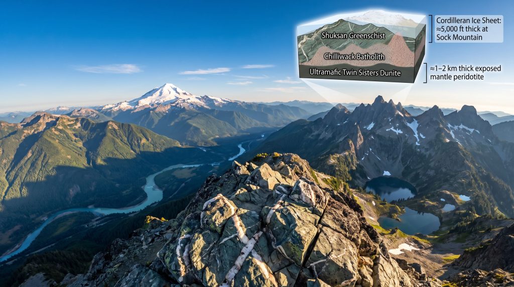
Few geological features in the entire Pacific Northwest are as extraordinary as the Twin Sisters dunite body. Visible from Sock Mountain's summit, this rock mass represents something that almost never reaches the surface: a fragment of the Earth's upper mantle, thrust upward through tectonic processes and now exposed.
The Twin Sisters are composed primarily of dunite, an ultramafic rock made almost entirely of the mineral olivine. Olivine is the dominant mineral of the Earth's upper mantle, and finding it at the surface in a body estimated to be one to two kilometres thick is genuinely unusual. Consequently, this makes the Twin Sisters one of the largest exposed dunite bodies in North America.
Understanding the mineralogy of ores in ultramafic settings like this one has significant implications for resource exploration, as dunite bodies can host economically important minerals including chromite and nickel sulphides.
Dating the Twin Sisters presents a fundamental problem for geologists. Ultramafic mantle rocks like dunite lack the mineral assemblages typically used for radiometric dating, making it extremely difficult to establish when this material was emplaced. Its structural isolation from surrounding rock types adds further interpretive complexity about the deep crustal processes involved.
Mount Baker Volcano: A Young Volcano Sitting on Ancient Crust
Mount Baker is striking not only for its visual dominance of the northern Washington skyline but for the radical age contrast it represents. The volcano's edifice is geologically young, measured in tens of thousands to a few hundred thousand years of volcanic activity. The basement rocks it sits upon exceed 100 million years in age.
Key observations about the Baker system from Sock Mountain include:
- Yellow Aster Butte and similar ridges expose the pre-volcanic basement underlying the volcano
- The Black Buttes, visible as dark pyramidal forms flanking Baker's main cone, represent older volcanic remnants from earlier eruptive phases
- Aerial reconnaissance of Glacier Peak revealed a striking greenschist contact directly beneath that volcano's edifice, illustrating that this volcano-on-ancient-basement relationship is a recurring pattern across the range
The age contrast between Mount Baker's volcanic activity and the metamorphic basement beneath it exceeds 100 million years in some cases, and may be even greater. A young stratovolcano sitting directly on top of some of the most ancient and tectonically complex crust in North America represents one of the more visually dramatic unconformities in the region.
How Did the Landscape Get Its Shape? Reading Glacial History from Sock Mountain's Summit
Two Glacial Systems, One Landscape: Alpine Ice vs. Continental Ice Sheet
One of the most important conceptual distinctions in North Cascades glacial geology is the difference between local alpine glaciation and the continental-scale Cordilleran Ice Sheet. These two systems operated at fundamentally different scales, produced opposite topographic effects, and left different signatures in the landscape.
| Feature | Alpine Glaciation | Cordilleran Ice Sheet |
|---|---|---|
| Ice source | Local mountain snowfields | Canadian ice accumulation zones |
| Scale | Valley to cirque scale | Continental, hundreds of kilometres |
| Landscape effect | Cirques, arêtes, sharp peaks | Rounded ridges, overtopped summits, U-shaped valleys |
| Direction of flow | Radially outward from peaks | Predominantly south via Puget Lobe |
| Terminus | Local valley floors | Olympia, Washington (Puget Lobe) |
Alpine glaciers sharpen the landscape. They carve cirques, create arêtes, and produce the jagged profiles characteristic of high mountain terrain. Continental ice sheets, however, do the opposite: they bury, round, and smooth the landscape by overtopping ridges and shaving peaks that cannot protrude above their surface.
The Cordilleran Ice Sheet in Western Washington: Scale, Depth, and Direction
The Cordilleran Ice Sheet was a continental-scale ice mass that originated in British Columbia and advanced southward into Washington State during the Pleistocene epoch. Its dominant southern arm, the Puget Lobe, pushed through the Puget Lowland all the way to Olympia.
The estimated ice thickness across the Skagit Valley region at peak glaciation was approximately 5,000 feet from sea level to near the summit of Sock Mountain. To contextualise that figure:
- The towns of Mount Vernon and Sedro-Woolley, visible in the lowlands from Sock Mountain's summit, would have been buried entirely
- The ice surface would have reached approximately the elevation of Sock Mountain's summit itself
- Interstate 5 and the entire Puget Lowland corridor would have been under more than a vertical mile of ice
The eastern limit of the ice sheet in the Cascade foothills differed from its southern terminus in the lowlands because mountain topography created a natural barrier. Peaks like Sloan Peak appear to mark roughly the eastern edge of continuous continental ice penetration into the mountains.
What Is a Nunatak? Sock Mountain as a Possible Ice Island
At peak glaciation, Sock Mountain's summit sat at approximately the theoretical upper limit of the Cordilleran Ice Sheet. This raises the possibility that it functioned as a nunatak — a mountain summit that protrudes above a surrounding ice sheet, remaining ice-free as an island of rock in a white sea.
Evidence used by geologists to identify former nunataks includes:
- Absence of glacial polish and striation marks at the summit, indicating the ice never flowed over the peak
- Presence of frost-shattered angular debris, produced by freeze-thaw cycling rather than glacial abrasion
- Distinctive vegetation patterns reflecting long-term exposure rather than post-glacial colonisation
North Mountain, visible to the south from Sock Mountain's summit, offers a striking contrast. Its broad, shield-like profile is actually the product of the continental ice sheet flowing completely over its top, rounding and smoothing what was once a sharper ridge. Rinker Ridge, visible with clear-cuts along its flanks, provides another case study: its current rounded profile reflects the shaving effect of ice sheet overtopping rather than alpine sharpening.
The conceptual distinction here is important: alpine glaciers flow downhill and carve sharp features, while continental ice sheets behave more like viscous fluids under pressure, capable of flowing over ridges, burying entire mountain systems, and erasing topographic relief rather than creating it.
Ice Sheet "Leaks": How the Cordilleran Ice Sheet Crossed the Cascade Crest
One of the more counterintuitive chapters of North Cascades glacial history involves ice flowing not south, but east, through mountain passes. When the Cordilleran Ice Sheet grew thick enough in western Washington, the immense pressure of accumulated ice forced it to spill through low points in the Cascade crest, flowing uphill in some cases to reach eastern Washington.
Cascade Pass, visible from Sock Mountain as a distinct low point in the ridge above the Cascade River Valley, has been identified as the southernmost Cascade pass through which the Cordilleran Ice Sheet crossed to eastern Washington. The evidence is physical: transported greenschist and metamorphic clasts have been found in the Cascade River Valley, moved upvalley against the natural downstream gradient by the pressure of the advancing ice mass. Research by geologist John Riedel and colleagues documented this transported material and helped establish the pass as a key conduit.
Rainy Pass and the Granite Creek Valley served as another major conduit, with ice directed south toward Bridge Creek and ultimately contributing to filling the Lake Chelan basin. From Sock Mountain, both Cascade Pass and the broader mountain terrain leading toward Rainy Pass are visible, making the summit an exceptional vantage point for mentally reconstructing these ice pathways.
Unlike alpine glaciers that simply respond to gravity, continental ice sheets under sufficient accumulation pressure can flow uphill, cross drainage divides, and fill valleys from above rather than from below. This behaviour is more consistent with a viscous fluid under pressure than with the intuitive image of ice sliding downhill.
The Skagit River and Sauk River: Glacial Meltwater Signatures in the Modern Landscape
From Sock Mountain's summit, the confluence of the Skagit and Sauk rivers is visible below. The colour contrast between the two rivers provides a real-time lesson in the difference between dam-regulated and glacier-fed hydrology.
The Skagit River runs unusually clear. This is not its natural condition but an artificial one: upstream dams including Ross Dam and Diablo Dam trap virtually all suspended sediment, giving the river an appearance of clarity that masks what a free-flowing glacial river would look like.
The Sauk River, by contrast, carries genuine glacial flour produced by active glaciers on Glacier Peak Volcano grinding bedrock into particles fine enough to remain suspended in the water column. This creates the river's characteristic turquoise-to-milky colouration. During extreme heat events, accelerated glacial melt dramatically increases sediment load, and the Sauk can turn brown with the volume of material being delivered from Glacier Peak's retreating ice.
Cirques, Tarns, and Alpine Landforms: Evidence of Local Glaciation on Sock Mountain
Reading the Mountain's Own Glacial Biography
While the Cordilleran Ice Sheet dominates the broader glacial narrative, Sock Mountain also carries evidence of its own local alpine glacial history. A cirque — the characteristic bowl-shaped bedrock depression carved by a small alpine glacier — is visible on the mountain's north-facing slope. Within this cirque sits a tarn, a small glacially carved lake occupying the hollowed bedrock floor.
North-facing slopes preferentially preserve these features because reduced solar radiation allows snow to persist longer, sustaining the small glaciers that do the carving work. The contrast between Sock Mountain's locally glaciated sharp faces and the rounded, ice-sheet-modified ridges visible to the west and south illustrates both glacial systems operating simultaneously, at different scales and with opposite effects.
What Does the Bedrock of Sock Mountain Actually Look Like?
Field Observations: Outcrop Character and Rock Description
The bedrock exposed on Sock Mountain presents as a mixture of angular green rock fragments set within a darker grey matrix — a texture consistent with brecciated or mélange geology. Quartz veins cut through the outcrop at multiple orientations, providing their own story about the rock's history.
Quartz veins in metamorphic rocks form when silica-rich hydrothermal fluids migrate through fractures during burial and deformation at depth. Their presence in the Sock Mountain outcrops suggests these rocks were once buried to significant crustal depths before tectonic exhumation brought them to the surface. In regions with similar geological complexity, gossans in mineral exploration serve as surface indicators of buried mineralisation, demonstrating how surface geology can guide resource discovery even in heavily deformed terranes.
Mélange geology resists simple categorisation. The term itself derives from the French word for mixture, and that is precisely what it is: a geologically "complicated, ugly, contorted" assemblage that is, paradoxically, geologically fascinating precisely because it records the violent collision and stacking of crustal fragments over deep time.
The next major ASX story will hit our subscribers first
The Straight Creek Fault: A Major Structural Boundary Visible from Sock Mountain
What the Straight Creek Fault Reveals About North Cascades Tectonics
The Straight Creek Fault passes between White Chuck Mountain and Mount Pugh, both visible from Sock Mountain's summit and positioned so closely together from this vantage point that they appear nearly aligned. This fault is one of the major structural boundaries that helped assemble the North Cascades terrane mosaic through right-lateral strike-slip motion.
The regional geology significance of structures like the Straight Creek Fault extends well beyond the immediate mountain landscape, influencing basin development and sedimentary records across a broad area of the Pacific Northwest. Furthermore, the fault's position corresponds approximately to the eastern limit of Cordilleran Ice Sheet penetration into the mountain system, where peaks including Sloan Peak's dramatic horn profile formed an effective topographic barrier.
FAQ: Sock Mountain Geology and Glacial History
What Type of Rock Is Found on Sock Mountain?
Sock Mountain exposes rocks consistent with the Chilliwack Batholith and associated metamorphic packages of the North Cascades terrane mosaic. The outcrops show a brecciated or mélange-like texture with angular green fragments in a darker matrix and quartz veining throughout, reflecting deep burial, metamorphism, and tectonic stacking.
Was Sock Mountain Covered by Glaciers During the Last Ice Age?
Sock Mountain geology and glacial history places the summit at approximately the upper limit of the Cordilleran Ice Sheet during peak Pleistocene glaciation, with an estimated ice thickness of around 5,000 feet from sea level to near the summit. The peak may have functioned as a nunatak, barely protruding above the surrounding ice surface, while surrounding lowlands and lower ridges were completely buried.
What Is the Difference Between Alpine Glaciation and the Cordilleran Ice Sheet?
Alpine glaciation originates locally on mountain snowfields and creates sharp landforms like cirques and arêtes. The Cordilleran Ice Sheet was a continental-scale mass originating in Canada that buried entire valleys, rounded ridges by overtopping them, and operated at a fundamentally different scale with opposing topographic effects. For instance, geological activity at Rocky Mountain National Park provides a useful comparative example of how different glacial regimes shape mountain landscapes.
Why Does the Sauk River Look Milky or Turquoise?
The colour comes from glacial flour — extremely fine rock particles ground by active glaciers on Glacier Peak Volcano. This suspended sediment scatters light to produce turquoise to milky-white colouration, with intensity increasing during high melt periods and potentially turning brown during extreme heat events.
What Is a Nunatak?
A nunatak is a mountain peak or ridge that protrudes above the surface of a surrounding ice sheet, remaining exposed as an island of rock while all surrounding terrain is buried under ice.
How Did Ice Cross the Cascade Mountains During the Last Glaciation?
When the Cordilleran Ice Sheet grew thick enough in western Washington, it spilled eastward through low mountain passes including Cascade Pass and Rainy Pass, flowing uphill under immense pressure to reach eastern Washington and fill basins including Lake Chelan.
Key Takeaways: What Sock Mountain Teaches Us About North Cascades Geology
| Theme | Key Finding |
|---|---|
| Bedrock complexity | Stacked thrust sheets of different ages and origins — the "pizza box" model |
| Chilliwack Batholith | Major intrusive body forming much of the lower North Cascades terrain |
| Shuksan Greenschist | Metamorphic thrust sheet above Chilliwack; part of a regionally extensive stack |
| Twin Sisters | Rare exposed mantle peridotite; one of the largest dunite bodies in North America |
| Mount Baker | Young stratovolcano sitting unconformably on basement rocks more than 100 million years older |
| Cordilleran Ice Sheet | Approximately 5,000 feet thick at Sock Mountain; flowed south via Puget Lobe and east via mountain passes |
| Nunatak potential | Sock Mountain summit may have barely protruded above the ice sheet surface |
| Ice sheet passes | Cascade Pass and Rainy Pass served as conduits for ice crossing to eastern Washington |
| Sauk River colour | Active glacial flour from Glacier Peak glaciers; contrasts sharply with dam-regulated Skagit clarity |
| Straight Creek Fault | Major structural boundary visible from summit; corresponds to eastern limit of ice sheet penetration |
In addition, readers interested in broader comparisons of how glaciation shapes mountain geology globally will find the geological history of Pikes Peak a valuable reference, offering instructive parallels to the Sock Mountain geology and glacial history narrative explored throughout this article.
Further Exploration: Readers interested in exploring the field geology of Sock Mountain and the broader North Cascades in greater depth are encouraged to explore the Nick on the Rocks YouTube series, which features on-location geological discussions across northern Washington's mountain landscapes and offers an engaging field-based perspective on the topics covered in this article.
Ready to Turn Geological Insight Into Investment Discovery?
The same forces of deep time and tectonic complexity that shaped the North Cascades have concentrated mineral wealth across similarly dramatic geological terranes worldwide — and Discovery Alert's proprietary Discovery IQ model scans ASX announcements in real time to identify significant mineral discoveries the moment they are announced, transforming complex geological data into actionable investment insights. Explore historic discoveries and their exceptional returns, then begin a 14-day free trial to position yourself ahead of the broader market.