June 10, 2026
Mining Governance at an Inflection Point: Why Cadastre Reform Defines South Africa's Investment Future
Across the global mining industry, the efficiency of a country's licensing infrastructure functions as a silent signal to capital allocators. Before a drill turns, before a definitive feasibility study is commissioned, investors assess how quickly and transparently a jurisdiction processes the paperwork that precedes exploration. In this context, the South Africa mineral cadastre rollout is not simply a bureaucratic story. It is a frontline indicator of whether the country can compete for the wave of mineral exploration capital now circulating globally, particularly as critical minerals demand intensifies through the energy transition.
When big ASX news breaks, our subscribers know first
What the South Africa Mineral Cadastre Rollout Is Actually Replacing
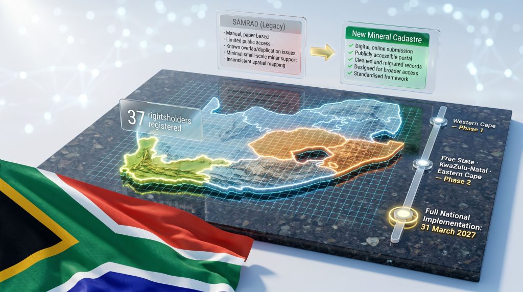
The Structural Failures of SAMRAD
The South African Mineral Resources Administration system, commonly known as SAMRAD, was the legacy platform through which mining and prospecting licence applications were submitted, processed, and tracked. Over time, it became synonymous with opacity, administrative backlog, and data integrity failures that undermined confidence in South Africa's licensing environment.
Among the most damaging inherited problems were instances of double-granted rights, where overlapping licences had been issued over the same ground due to inconsistent spatial data management. Boundary disputes arising from inaccurate records created legal uncertainty that delayed project development and increased transaction costs for operators attempting to verify the status of prospective ground.
The core deficiencies of SAMRAD compared to the intended new system are stark:
| Feature | SAMRAD (Legacy) | New Mineral Cadastre |
|---|---|---|
| Application processing | Manual, paper-based | Digital, online submission |
| Transparency | Limited public access | Publicly accessible portal |
| Data accuracy | Known overlap/duplication issues | Cleaned and migrated records |
| Small-scale miner support | Minimal | Designed for broader access |
| Spatial mapping standard | Inconsistent | Standardised framework |
The transition is not merely a software upgrade. It represents a structural reimagining of how South Africa governs access to its mineral resources at the administrative layer.
How a Mineral Cadastre System Actually Functions
The Technical Architecture Behind Licence Administration
A mineral cadastre, in its operational form, is a nationally integrated digital registry that manages every stage of the mining rights lifecycle. Its core functions include:
- Receiving and processing new licence applications through an online intake system
- Registering awarded rights within a spatially accurate database
- Managing renewals, transfers, and cancellations in real time
- Providing a publicly accessible mapping layer that displays active rights, pending applications, and excluded areas
- Generating audit trails that support both regulatory compliance and investor due diligence
One of the more technically contested dimensions of the rollout involves the mapping methodology applied to licence boundaries. The choice between a block-based grid system and a surveyed farm boundary system carries significant practical consequences. Block-based systems divide the landscape into uniform grid cells regardless of underlying property boundaries, which enables faster processing but can create boundary mismatches with existing land tenure.
Surveyed farm boundary systems align rights with established cadastral parcels, which are more legally precise but require substantially more data preparation. South Africa's century-plus mining history means legacy rights are often described in surveyed farm boundary terms, creating tension when migrating this data into a more standardised digital framework.
Jurisdictions such as Australia and Canada resolved this challenge over years of iterative system development, whilst Chile's Sernageomin operates a fully digital, block-based cadastre that is frequently cited as a benchmark for processing speed and transparency. Furthermore, the mining claims framework applied in British Columbia offers a useful comparative model for how jurisdictions manage cadastral transitions at scale.
Why Legacy Data Migration Is the Hidden Challenge
Jacob Mbele, Director-General of the Department of Mineral and Petroleum Resources (DMPR), has publicly acknowledged that South Africa's migration complexity is exceptional by global standards. He noted that centuries of mining history means an extraordinary volume of records must be cleaned, verified, and transferred before each provincial rollout can proceed.
This is not a trivial technical task. Each record must be cross-referenced for spatial accuracy, checked against active rights, and reconciled with historical grants that may predate modern cadastral standards by decades or more. According to reporting on the cadastre's Western Cape implementation, the data preparation workload has been among the most significant operational bottlenecks in the programme.
Where the Rollout Stands in Mid-2026
The Western Cape Pilot and Its Significance
The Western Cape became the first province to complete full migration from SAMRAD to the new digital cadastre system. As of mid-2026, 37 rightsholders had been registered under the new platform, and at least three applications had been submitted through the system without external assistance and subsequently reviewed by officials.
The DMPR confirmed these as unassisted digital submissions, which is a meaningful operational benchmark because it demonstrates that the system is functional beyond controlled testing conditions. The Western Cape was a logical pilot choice: it has a relatively smaller and more manageable dataset compared to the Witwatersrand or Limpopo, which carry far heavier historical rights loads, and its mining footprint is structurally less complex than the major platinum and gold provinces.
Parliament's Portfolio Committee reviewed the Western Cape deployment and provided a broadly positive assessment whilst identifying areas where further development was required, particularly around small-scale and artisanal miner access pathways.
What the Expansion Sequence Looks Like
The DMPR has confirmed that the next phase of the South Africa mineral cadastre rollout will target three additional provinces:
- Free State
- KwaZulu-Natal
- Eastern Cape
These provinces represent a step-up in complexity relative to the Western Cape pilot, particularly the Free State, which hosts significant gold mining history and its associated legacy rights complexity.
The DMPR's stated completion target for full national implementation is 31 March 2027, aligning with the end of its 2026-27 financial year. Mbele publicly committed to this timeline at the Junior Indaba conference in June 2026, framing it not as an aspiration but as an operational commitment. That framing matters: it transforms the March 2027 date into a formal accountability benchmark against which the department's performance will be measured.
Key Policy Marker: The DMPR has publicly committed to completing the national cadastre rollout within its 2026-27 financial year. This deadline now functions as a formal accountability benchmark for the industry and for parliamentary oversight.
Industry Concerns About Transparency and Technical Fitness
The Demonstration Dispute
The Minerals Council South Africa raised formal concerns about the cadastre at its annual general meeting on 27 May 2026, noting that despite requesting a system demonstration, it had not been granted access to review the platform. This absence of independent technical review generated questions within the industry about whether the system met South Africa's unique cadastral design specifications before being deployed provincially.
The DMPR subsequently indicated it would present the cadastre to the Minerals Council following the Junior Indaba, and the system is publicly accessible via a staging portal at staging-mininglicense.dmpr.gov.za. However, a staging portal and a structured technical demonstration are not equivalent. A credible demonstration to industry stakeholders would need to cover:
- Spatial data accuracy and boundary resolution methodology
- Processing workflow for both prospecting and mining right applications
- Handling of historical record conflicts and overlap resolution
- Public access functionality and reporting capabilities
- System performance benchmarks under operational load
In addition, the Minerals Council's published concerns about ongoing delays highlight the growing frustration within the sector regarding the pace of transparent technical engagement.
Design Specification Risks
The underlying concern about whether the cadastre software fully aligns with South Africa's spatial data requirements has not been publicly resolved. The block-based versus surveyed farm boundary debate carries downstream consequences: if the system processes rights using a spatial standard that does not accurately reflect historically established boundaries, it could generate a new generation of boundary disputes even as it attempts to resolve inherited ones.
Industry Caution: Prolonged delays in confirming the cadastre's technical specifications have compounded uncertainty among mining investors, particularly junior and exploration-stage companies most dependent on efficient and accurate licence processing.
How Policy Uncertainty Is Compounding the Cadastre Challenge
The IDS and Beneficiation Conditions: A New Risk Layer
On the same week that Mbele addressed the Junior Indaba conference, the Department of Trade, Industry and Competition published its Industrial Development Strategy (IDS) in June 2026. The document proposed attaching beneficiation conditions to the award of mining licences, a structural intervention that would embed industrial policy objectives directly into the licensing framework.
The DTIC's strategy document stated that a review of mining legislation on mineral rights allocation was critical to enable the attachment of beneficiation conditions in line with international mining, trade, and investment laws. The DMPR, when pressed on the issue at the Junior Indaba, acknowledged the broader beneficiation debate whilst characterising the IDS as a proposal rather than enacted policy.
Mbele drew a distinction between the DMPR's position and the DTIC's published strategy, but that distinction provided limited reassurance to an industry audience already navigating cadastre uncertainty. Mzila Mthenjane, CEO of the Minerals Council, characterised the IDS as an invitation for structured engagement, noting that its 45-page scope required careful analysis before formal industry responses could be developed.
The Chrome Export Tax: A Policy Signal That Refuses to Disappear
The IDS also revived a proposal to implement tariffs or negotiated pricing arrangements for the chrome sector, a measure the industry had broadly understood to have been abandoned following earlier consultation processes. Its reappearance in the strategy document generated disproportionate concern relative to its current legal status as a discussion-stage proposal.
This is a recurring feature of South Africa's mining policy environment: the repeated surfacing of measures that were thought settled creates a compounding uncertainty premium that affects junior exploration investment decisions even before legislation moves. Furthermore, concerns about government intervention in mining have become increasingly prominent as investors weigh the cumulative effect of these policy signals.
| Policy Dimension | South Africa (2026) | Peer Benchmark (Australia, Canada) |
|---|---|---|
| Licence processing system | Transitioning (partial rollout) | Fully digital, nationally consistent |
| Beneficiation conditions on licences | Under active policy debate | Minimal or absent |
| Export tax proposals | Reintroduced in IDS (chrome) | Rare; subject to formal consultation |
| Industry consultation process | Reactive/post-publication | Structured pre-publication engagement |
The next major ASX story will hit our subscribers first
What This Means for Junior Miners and Exploration Capital
Why Smaller Operators Face Disproportionate Exposure
Major mining houses can absorb administrative delays through portfolio diversification, legal capacity, and long-term operational inertia. Junior miners and exploration-stage companies operate under different constraints. For them, prospecting right processing speed is not an administrative convenience but a capital deployment prerequisite.
Investor timelines, work programme commitments, and licence expiry windows create hard deadlines that do not flex for system migration delays. The Western Cape pilot's confirmation of unassisted digital applications is a meaningful signal for this cohort. If the system functions as designed at national scale, it has the potential to reduce application processing times materially and provide real-time visibility over application status, which alone would represent a structural improvement over SAMRAD's opacity.
The Parliament Portfolio Committee's acknowledgment of small-scale and artisanal miner support features within the new system also points to a broadening of the cadastre's intended user base, extending its potential benefit beyond formal sector operators.
What Must Happen Before the Cadastre Becomes a Capital Enabler
For the South Africa mineral cadastre rollout to function as a genuine investment enabler rather than merely an administrative upgrade, several conditions must be met:
- National spatial consistency: All nine provinces must operate under the same mapping standard with no legacy data anomalies persisting in the migrated records
- Transparent processing benchmarks: Measurable application turnaround times must be published and monitored
- Public access functionality: The rights registry must be searchable, accurate, and current in real time
- Policy stability overlay: The cadastre's technical performance must not be undercut by concurrent policy changes that alter the conditions under which licences are granted
Frequently Asked Questions: South Africa Mineral Cadastre Rollout
What is the South Africa mineral cadastre?
The mineral cadastre is South Africa's national digital platform for administering mining and prospecting rights. It covers new applications, renewals, transfers, and spatial rights registration, and is designed to replace the legacy SAMRAD system with a transparent, online, and publicly accessible framework.
When will the mineral cadastre be fully operational across South Africa?
The DMPR has committed to completing full national implementation by 31 March 2027, aligned with the end of its 2026-27 financial year. This target is subject to successful data migration across the remaining provinces.
Which provinces have the new system so far?
As of mid-2026, the Western Cape is the only province to have fully migrated from SAMRAD to the new cadastre. The Free State, KwaZulu-Natal, and Eastern Cape are confirmed as the next phase provinces.
Why has the rollout taken so long?
The primary constraint is the complexity of migrating centuries of mining records from SAMRAD into the new system. Issues including overlapping rights, inaccurate spatial data, and the need to reconcile historical grants with modern cadastral standards extend the migration timeline for each province. Additionally, industry reporting on the cadastre delay confirms that resourcing constraints within the DMPR have also contributed to the extended timeframe.
How does the IDS beneficiation proposal affect mining licences?
The IDS proposes embedding beneficiation conditions directly within mining licence awards, meaning licence applicants could face requirements to process or add value to minerals domestically as a condition of receiving or renewing rights. This remains a proposal as of mid-2026, but the industry is monitoring its progression closely given its potential to fundamentally alter the licensing framework.
The Road to March 2027: Three Scenarios
Scenario 1: On-Track National Deployment
If data migration across Free State, KwaZulu-Natal, Eastern Cape, and the remaining provinces proceeds without major technical conflicts, and if the spatial mapping disputes are resolved in favour of a consistent national standard, the March 2027 deadline is achievable. Under this scenario, South Africa would enter 2027 with a functioning national digital cadastre, improved processing transparency, and a reduced incidence of double-granting. Investor sentiment, particularly among junior explorers, would likely respond positively.
Scenario 2: Partial Rollout With Persistent Provincial Gaps
Data migration in higher-complexity provinces may encounter delays driven by record volume, unresolved boundary conflicts, or DMPR capacity constraints. Under this scenario, the Western Cape would operate on the new system whilst most other provinces remained on SAMRAD processes, creating a two-speed licensing environment. This outcome would validate industry concerns about rollout credibility without providing a resolution.
Scenario 3: Policy Overlay Disruption
If the IDS beneficiation conditions are formalised and written into licensing requirements before the cadastre achieves full national coverage, the compounded uncertainty of simultaneous technical and policy transition could materially suppress exploration investment. The cadastre would still exist, but the terms under which it grants rights would be shifting at the same time the system itself remains in migration, amplifying risk for capital allocators.
Strategic Implication: The March 2027 deadline is more than a technical target. It is a test of South Africa's capacity to execute regulatory modernisation under simultaneous policy pressure. The DMPR's performance in this window will carry material weight in the country's mining investment reputation through the late 2020s.
The Credibility Gap the DMPR Must Close
The Western Cape pilot has demonstrated that the core technology functions. Unassisted digital applications have been submitted and reviewed. Rightsholders have been registered. The system exists and it works in a controlled provincial environment.
What the DMPR has not yet demonstrated is that it can replicate this outcome at national scale, in provinces carrying vastly more complex data loads, whilst simultaneously managing the political pressure of a beneficiation debate that is pulling at the foundations of the licensing framework.
For investors evaluating South Africa's mining sector, the South Africa mineral cadastre rollout is not just a technical milestone to track. It is a proxy for whether the country's governance institutions can execute under pressure, deliver on public commitments, and produce the administrative infrastructure that underpins long-term resource sector investment. The March 2027 deadline will answer that question one way or another.
This article is intended for informational purposes only and does not constitute financial or investment advice. Statements regarding policy proposals, rollout timelines, and regulatory developments are based on publicly available information as of mid-2026 and are subject to change. Readers should conduct their own due diligence before making investment decisions related to the South African mining sector.
Want to Capitalise on Major ASX Mineral Discoveries Before the Broader Market?
Discovery Alert's proprietary Discovery IQ model delivers real-time alerts on significant ASX mineral discoveries, instantly transforming complex mineral data into actionable investment insights for both short-term traders and long-term investors — explore historic examples of exceptional discovery returns to understand the potential, and begin your 14-day free trial at Discovery Alert to position yourself ahead of the market.