May 20, 2026
Understanding Structural Controls in Andean Mineral Systems
The relationship between geological architecture and mineral distribution in orogenic belts represents one of the most fundamental challenges in modern exploration geology. When examining how tectonic processes control ore formation, few regions offer the complexity and clarity found in high-altitude mountain systems where multiple deformation episodes have created intricate structural geometries that guide mineralizing fluids through predictable pathways. This approach builds upon established mineral exploration fundamentals that emphasise systematic geological investigation.
Permo-Triassic Basin Architecture and Its Role in Ore Formation
The Central Peruvian Andes represents one of the world's most prolific metallogenic regions, with polymetallic mineralisation spanning approximately 800 kilometres along the Andean chain. The Morococha district alone has produced over 3.2 million metric tons of lead and zinc since the beginning of documented mining operations in the 17th century. The elevation of the field area ranges from 4,100 to 4,800 metres above sea level, with the township of La Oroya situated at 3,752 metres and serving as the regional hub.
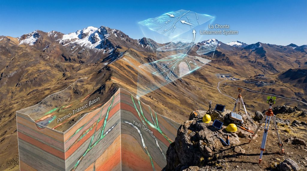
The Permo-Triassic strata in the Yauli Dome region display stratigraphic thicknesses ranging from 1,200 to 1,800 metres across the basin architecture, with the Mitu Group comprising primarily siliciclastic sequences and the Pucará Group dominated by carbonates. These formations have undergone multiple episodes of tectonic deformation during the Andean orogeny, with maximum burial depths estimated between 3 and 5 kilometres based on vitrinite reflectance and conodont alteration index studies. Furthermore, modern 3D geological modelling techniques enable detailed visualisation of these complex structural relationships.
The structural evolution of ancient extensional basins demonstrates how initial rift geometry controlled sediment distribution patterns, which subsequently influenced fluid flow pathways during later mineralisation events. This relationship between primary sedimentary architecture and secondary structural modification represents a fundamental principle in applied exploration geology, where understanding inherited structural geometries enhances the ability to predict ore body locations.
Mesozoic Back-Arc Basin Characteristics
The Mitu and Pucará Groups function as both source rocks for metallogenic fluids and host rocks for ore deposition, depending on their stratigraphic position and degree of structural disruption. The lateral facies variations within these sequences create significant exploration opportunities, particularly where competency contrasts between siliciclastic and carbonate lithologies create preferential sites for brittle fracturing and fluid concentration.
The Permo-Triassic basin developed as an intracontinental extensional system during the Early Permian, with the Yauli Dome representing a structural high that experienced both subsidence and uplift patterns controlled by basement-involved faulting. Structural analysis of the basin margins reveals the presence of syn-rift sequences that thin and onlap toward the dome structure, indicating active tectonics during deposition.
The basin fill exhibits characteristics consistent with starved basin deposition, where terrigenous influx was limited and authigenic carbonate precipitation dominated certain intervals. The mineralisation within Permo-Triassic host rocks is predominantly hosted in carbonate units of the Pucará Group, which experienced dolomitisation along fault zones and fracture corridors.
When big ASX news breaks, our subscribers know first
How Do Tectonic Lineaments Control Mineralisation Patterns?
Regional-scale structural features represent the fundamental framework that controls mineral distribution across entire metallogenic provinces. These deep-seated structural zones function as conduits for ore-forming fluids, creating systematic patterns of mineralisation that can be recognised and exploited through systematic geological analysis. Consequently, comprehensive drilling program insights become essential for targeting these structural zones effectively.
The La Chonta Lineament System
The La Chonta lineament represents a major regional-scale structural feature extending for approximately 120 kilometres through the Central Peruvian Andes, trending northwest-southeast. This lineament shows evidence of repeated reactivation, with documented movement throughout the Mesozoic era and continued activity into the Tertiary. Mineralisation deposits associated with the La Chonta system include multiple skarn and porphyry occurrences, with some historical production records documenting ore grades of 3-8% combined lead and zinc.
The lineament functions as a fundamental structural partition within the central Andes, controlling the distribution of mineralisation at multiple scales ranging from microscopic fracture patterns to macroscopic basin geometries. The lineament represents a zone of cumulative displacement where hundreds of metres of structural relief has accumulated over geological time, creating a complex architecture of subsidiary fractures and fault segments.
Syn-orogenic sequences related to the La Chonta system show thickness variations of up to 40% across relatively short distances (5-10 kilometres), indicating active tectonics during sedimentation. These sequences contain interbedded volcaniclastic material with age constraints ranging from Palaeocene to Eocene, based on radiometric dating of zircon minerals.
Andean Deformation Styles and Their Prospective Value
The Andean deformation front in this region exhibits thin-skinned characteristics in areas where detachment horizons occur within evaporitic or weak shale sequences, while thick-skinned tectonics predominates in areas where basement faults were reactivated during compression. The transition between these styles occurs across a relatively narrow zone, approximately 10-15 kilometres wide, in the Morococha district.
The La Chonta lineament exhibits characteristics of a wrench fault system with evidence of both right-lateral and dip-slip movement, suggesting a complex kinematic history influenced by changing stress orientations during the Andean orogeny. The fault exhibits a steeper dip angle (approximately 55-70 degrees from horizontal) compared to regional thrust structures, which typically dip between 20-40 degrees.
Kinematic analysis of slickensides and fracture populations associated with the lineament reveals multiple phases of movement, with principal stress directions having rotated approximately 30 degrees across the Eocene-Oligocene boundary. This stress reorientation resulted in structural reactivation patterns that created new pathways for fluid migration.
Advanced Field Methodology for Exploration Professionals
Modern exploration geology demands systematic approaches to structural data collection that can withstand statistical analysis and provide quantitative constraints on geological processes. The integration of traditional field techniques with digital technologies creates comprehensive datasets suitable for three-dimensional modelling and predictive analysis. In addition, these methods integrate seamlessly with digital mining operations to enhance exploration efficiency.
Integrated Structural-Sedimentary Analysis Techniques
The PROEXPLO 2026 field trip Morococha-La Oroya will demonstrate how integrated structural-sedimentary analysis represents the fundamental framework for modern exploration geology. This approach combines strain analysis with palaeoenvironmental interpretation, enabling exploration professionals to distinguish primary features from secondary features representing post-depositional deformation.
Field mapping protocols for complex terrains require systematic documentation of:
- Rock type and weathering state
- Structural attitude (dip and dip direction)
- Fracture density and orientation patterns
- Alteration mineralogy and distribution
- Vein density and geometric relationships
- Observable metal indicators such as gossan textures
The Morococha field area covers approximately 380 square kilometres, with accessible outcrop exposure estimated at 45-55% of the total area. The PROEXPLO 2026 field trip Morococha-La Oroya will traverse a route covering approximately 65 kilometres of cumulative distance across three days of fieldwork, allowing for detailed structural observation at approximately 15-20 individual study stations.
Multi-Scale Geological Observation Frameworks
Kinematic analysis methods involve measuring the orientation of slickenside lineations relative to fault plane orientation, which together constrain the direction of fault movement. When multiple measurements are collected from different structural domains, the cumulative dataset reveals stress tensor orientations that changed systematically through time.
The density of structural measurements typically collected during professional field campaigns in this region ranges from 40-80 individual measurements per study day, depending on outcrop accessibility and complexity. A three-day programme would therefore generate approximately 120-240 structural data points suitable for stereonet analysis and statistical interpretation.
Stereonet methodology involves plotting measured structural attitudes on a lower-hemisphere equal-area stereographic projection, where clusters of poles reveal dominant orientations and statistical analysis reveals confidence levels for those orientations. The statistical treatment of stereonet data employs methods such as Fisher statistics to calculate confidence cones around mean orientations. Furthermore, these data provide critical input for interpreting drill results when integrated with subsurface information.
Why High-Altitude Geological Training Delivers Unique Learning Outcomes
Professional geological training in high-altitude environments presents unique challenges and opportunities that cannot be replicated in lower-elevation settings. The combination of extreme environmental conditions, complex geological exposures, and logistical constraints creates learning experiences that develop advanced field skills and risk management capabilities.
Environmental Challenges and Safety Protocols
The Morococha-La Oroya corridor maintains elevations consistently above 4,000 metres, with many observation points exceeding 4,500 metres above sea level. At these elevations, atmospheric oxygen content drops to approximately 60% of sea-level concentrations, creating physiological stresses that require careful acclimatisation protocols and modified work procedures.
High-altitude geological training requires specialised equipment considerations including:
- Cold-weather geological tools and instruments
- Supplemental oxygen systems for emergency situations
- Enhanced GPS accuracy systems for precise location recording
- Weather-resistant digital data collection equipment
- Specialised compass systems calibrated for magnetic declination variations
Temperature fluctuations in high-altitude Andean environments can exceed 30 degrees Celsius within a single day, ranging from below-freezing nighttime conditions to intense solar radiation during midday periods. These extreme conditions affect both human performance and instrument accuracy, requiring modified field procedures and enhanced safety protocols.
Logistical Planning for Professional Development Programmes
The PROEXPLO 2026 field trip Morococha-La Oroya programme demonstrates the complexity of organising professional geological training in remote high-altitude locations. The three-day programme requires coordination of transportation, accommodation, emergency medical support, and specialised field equipment for participants from diverse international backgrounds.
Transportation logistics in the Central Peruvian Andes involve navigating mountain roads with grades exceeding 8% and elevation changes of over 1,500 metres within single-day travel segments. Vehicle requirements include four-wheel-drive capabilities, emergency communication systems, and mechanical reliability at high altitude where oxygen-depleted conditions affect engine performance.
Accommodation planning for multi-day geological programmes requires facilities capable of supporting 20-30 participants while providing access to geological study areas within reasonable travel distances. The limited infrastructure in high-altitude mining districts necessitates advance coordination with local communities and mining operations to ensure adequate lodging and meal facilities.
Geological Significance of the Central Peruvian Andes
The metallogenic significance of the Central Peruvian Andes extends far beyond individual mining districts, representing a world-class example of how tectonic processes control the formation and distribution of polymetallic ore deposits across regional scales. Understanding these relationships provides insights applicable to exploration programmes worldwide.
World-Class Mineral District Characteristics
The Cerro de Pasco skarn deposits, located approximately 35 kilometres south of the primary field area, lie directly on a splay of the La Chonta lineament system. These deposits contain over 3.2 million metric tons of historical production and demonstrate direct structural control, with ore bodies occurring preferentially along fault-related fracture zones where orthogonal conjugate patterns created three-dimensional fluid trapping geometries.
The structural architecture immediately adjacent to major lineaments shows increased fracture density compared to background rock, with fracture spacing narrowing from approximately 30-40 centimetres in undeformed rock to 5-15 centimetres within 100 metres of the main fault trace. This systematic spatial relationship provides quantitative criteria for exploration targeting.
Polymetallic mineralisation in the region exhibits characteristic metal zoning patterns with:
- Lead-zinc dominance in carbonate-hosted replacement deposits
- Copper-molybdenum associations in porphyry-related systems
- Silver-bearing epithermal veins in volcanic-sedimentary sequences
- Tin-tungsten occurrences in granitic intrusion contact zones
Regional Metallogenic Framework
The temporal evolution of mineralisation events in the Central Peruvian Andes spans multiple geological periods, with the most economically significant deposits formed during Miocene magmatic activity between 15 and 8 million years ago. This timing corresponds to peak Andean uplift and the development of the current structural architecture that controls ore body distribution.
Magmatic-hydrothermal system development followed predictable patterns related to crustal thickening and deformation, where systematic changes in stress orientation created zones of dilation that focused mineralising fluids. The recognition of these patterns provides exploration vectors applicable to similar tectonic settings worldwide.
The relationship between structural preparation and ore emplacement demonstrates that mineralisation required pre-existing structural architecture to create permeability pathways. This relationship indicates that exploration programmes must integrate structural analysis with geochemical and geophysical techniques to identify areas where both structural preparation and hydrothermal activity coincided.
Professional Development Through Applied Geological Education
The integration of theoretical geological knowledge with practical field experience represents the cornerstone of professional development in exploration geology. Comprehensive field training programmes provide unique opportunities to develop skills that cannot be acquired through classroom instruction or laboratory work alone.
Target Audience and Learning Objectives
The PROEXPLO 2026 field trip Morococha-La Oroya addresses the professional development needs of geologists, geocientists, exploration professionals, and advanced students seeking specialised knowledge in structural controls on mineralisation. The programme recognises that modern exploration requires interdisciplinary skills combining structural geology, economic geology, and risk assessment capabilities.
Advanced geoscientist skill development in high-altitude environments provides exposure to geological complexity that enhances problem-solving abilities and spatial reasoning skills. Participants develop enhanced abilities to:
- Recognise structural control patterns in complex deformed terrains
- Integrate multi-scale observations from microscopic to regional scales
- Apply kinematic analysis techniques for stress history reconstruction
- Evaluate exploration vectors based on structural-mineralogical relationships
- Assess geological risk factors in challenging field environments
Integration with International Mining Conferences
The timing of the PROEXPLO 2026 field trip Morococha-La Oroya from May 8-10, 2026, following the main PROEXPLO conference in Lima from May 4-6, demonstrates the strategic integration of field education with international professional networking opportunities. This sequence allows participants to apply theoretical concepts discussed during conference presentations immediately through hands-on field observation.
Pre-conference technical training programmes provide enhanced value for international participants by combining exposure to cutting-edge research presentations with practical field application. However, the integration creates comprehensive learning experiences that justify the travel costs and time investment required for international participation. Furthermore, specialised courses offered prior to the congress provide additional technical depth for interested professionals.
Knowledge transfer between academic and industry sectors occurs most effectively when theoretical research can be demonstrated through field examples. The Morococha-La Oroya corridor provides exceptional opportunities for this knowledge transfer, where academic research on Andean tectonics can be directly related to practical exploration applications.
The next major ASX story will hit our subscribers first
Economic Geology Applications in Modern Exploration
The application of structural geology principles to economic geology represents one of the most practical and immediately applicable aspects of geological education. Understanding how geological processes control ore formation provides direct benefits for exploration decision-making and resource evaluation.
Structural Control Recognition for Resource Evaluation
Ore body geometry prediction methods based on structural analysis provide quantitative constraints on resource continuity and grade distribution patterns. The recognition that ore bodies follow predictable structural controls enables exploration programmes to optimise drilling programmes and reduce exploration costs through targeted investigation of high-probability areas.
The Santa Rosa vein system in the adjacent Lauricocha district demonstrates how kinematic analysis can reveal fluid flow pathways, with slickenside lineations indicating nearly horizontal movement on steeply dipping fault planes. This analysis demonstrates that dilation of fractures occurred along extensional jogs where the fault trace bent laterally, creating preferential sites for mineral precipitation.
Grade continuity assessment techniques based on structural analysis recognise that ore grade distributions follow structural patterns rather than random distributions. This recognition enables resource estimation procedures to incorporate geological constraints that improve accuracy and reduce uncertainty in resource calculations.
Technology Integration in Field-Based Learning
Digital data collection systems have revolutionised field geology by enabling real-time integration of structural measurements with geographic positioning and digital photography. Modern field programmes demonstrate how these technologies enhance traditional field techniques rather than replacing fundamental geological observation skills.
The application of unmanned aerial vehicle technology to geological mapping provides three-dimensional perspectives on structural relationships that cannot be observed from ground-based positions. This technology integration enables rapid reconnaissance of large areas while maintaining detailed observation capabilities at specific study locations.
Geographic information systems for exploration planning enable systematic integration of geological, geochemical, and geophysical data within a spatial framework that supports quantitative analysis and hypothesis testing. The Morococha-La Oroya field area provides exceptional opportunities to demonstrate these integrated approaches where multiple datasets can be compared with direct field observations.
Future Directions in Geological Field Education
The evolution of geological education reflects changing industry needs, technological capabilities, and educational methodologies that enhance learning outcomes while maintaining the fundamental field observation skills that remain central to geological practice.
Evolving Training Methodologies
Virtual reality integration with field experiences represents an emerging technology that can enhance pre-field preparation and post-field analysis without replacing actual field observation. These technologies enable participants to review complex three-dimensional structural relationships and practice measurement techniques before encountering challenging field conditions.
Drone-assisted geological mapping techniques provide new perspectives on structural relationships while demonstrating how traditional field skills integrate with modern technology. The PROEXPLO 2026 field trip Morococha-La Oroya represents opportunities to demonstrate these integrated approaches where participants can observe how aerial perspectives enhance ground-based observations.
Collaborative international training programmes create opportunities for knowledge exchange between professionals from different geological settings and mining traditions. The diversity of international participation in programmes like PROEXPLO 2026 field trip Morococha-La Oroya enhances learning outcomes by exposing participants to different approaches and perspectives on similar geological problems.
Industry Demand for Specialised Geological Skills
Critical mineral exploration requirements have increased demand for geologists with specialised skills in complex structural settings where traditional exploration approaches may be inadequate. The growing strategic importance of lithium, rare earth elements, and battery metals requires enhanced understanding of the structural controls that localise these commodity types.
Sustainable mining development considerations increasingly require geological understanding that goes beyond simple ore body delineation to include evaluation of environmental risks, community impacts, and long-term resource stewardship. Field training programmes must address these broader considerations while maintaining focus on fundamental geological principles.
Advanced analytical capabilities in field settings enable real-time decision-making that can optimise exploration programmes and reduce environmental impacts through more targeted investigation procedures. The integration of portable analytical equipment with traditional field techniques represents a significant advancement in exploration efficiency and environmental responsibility.
This article is based on educational content related to the Instituto de Ingenieros de Minas del Perú (IIMP) and their proEXPLO conference series, which offers comprehensive technical programmes for mining professionals. All geological data and interpretations should be verified through independent professional evaluation before application to specific exploration programmes.
Ready to Stay Ahead of the Next Structural Discovery?
Discovery Alert's proprietary Discovery IQ model instantly identifies significant ASX mineral discoveries, including those involving complex structural controls like those found in world-class districts. Subscribers gain immediate access to actionable insights that could reveal the next major mineralised system before the broader market recognises its potential. Begin your 14-day free trial today and explore how historic discoveries have delivered exceptional returns for early-positioned investors.