August 25, 2026
The Geological Architecture Behind Australia's Most Talked-About Onshore Oil Play
Onshore hydrocarbon exploration in Australia has long occupied a secondary position relative to the country's prolific offshore basins, but a quiet shift is underway in Queensland's interior. The Taroom Trough, a structural sub-basin embedded within the broader south Bowen Basin system, is accumulating a body of appraisal evidence that is difficult to ignore. The Omega Canyon-3 Taroom Trough discovery represents the latest and most technically detailed addition to that evidence base, and what it reveals about reservoir architecture, areal continuity, and hydrocarbon distribution is reshaping how exploration geologists are thinking about Permian-age plays in this part of the continent.
When big ASX news breaks, our subscribers know first
Why the Taroom Trough Deserves Serious Geological Attention
The Taroom Trough is not a standalone geological feature. It functions as a structurally defined sub-basin within the south Bowen Basin, a Permian-age sedimentary system that extends across a substantial portion of central and southern Queensland. What distinguishes the Taroom Trough from many of its onshore Australian counterparts is the presence of stacked Permian reservoir sequences, where multiple sandstone units are vertically superimposed within a single stratigraphic column, rather than a single pay horizon requiring separate well targets.
Stacked reservoir systems carry significant economic implications. A single wellbore can potentially intersect multiple productive zones, improving capital efficiency per metre drilled. The presence of overpressure indicators within the Permian interval is also geologically meaningful. Overpressured systems often indicate that hydrocarbons have been generated and retained within a sealed system over geological timescales, reducing the risk of charge failure in appraisal drilling.
The Canyon Sandstone sits as the primary target within this stratigraphic framework, but it does not operate in isolation. It is underlain and overlain by additional sandstone units that collectively form the multi-zone stack now confirmed across three appraisal wells. Proximity to the Cabawin oil field to the east functions as both a geological analogue and a directional indicator for hydrocarbon migration pathways, adding independent support to the charge model underpinning the Canyon project.
How the Taroom Trough Compares to Other Queensland Onshore Plays
Onshore Queensland hosts several petroleum systems of varying maturity, but few have demonstrated the lateral sandstone continuity now emerging from the Taroom Trough dataset. In conventional reservoir appraisal, lateral continuity is arguably more commercially decisive than vertical thickness alone. A thick pay zone that pinches out rapidly over distance has limited development scalability. A thinner pay zone that persists across tens of kilometres, however, can support a drilling program spanning dozens of wells.
The Canyon Sandstone is increasingly demonstrating characteristics of the latter type. Regional well correlations are extending its mapped footprint well beyond what was initially outlined at discovery, and each new data point is reinforcing rather than undermining the lateral continuity thesis. Furthermore, interpreting drill results across multiple well locations remains central to confirming that continuity with sufficient confidence.
Breaking Down the Canyon-3 Well: What the Data Actually Shows
Key Reservoir Metrics from Canyon-3 at a Glance
The technical results from Canyon-3 are best understood through direct comparison with earlier well data, particularly Canyon-1, which serves as the discovery reference point for the project.
| Parameter | Canyon-3 Result | Canyon-1 Equivalent | Change |
|---|---|---|---|
| Total Depth Drilled | 3,792.6 m | — | — |
| Permian Interval Thickness | 526 m | — | — |
| Aggregate Net Pay | 170 m | — | — |
| Canyon Sandstone Gross Thickness | 42 m | 37 m | +13.5% |
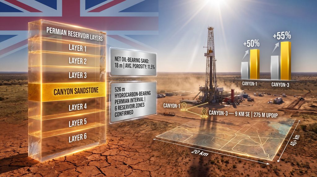
| Net Oil-Bearing Sand | 18 m | 12 m | +50% |
| Average Porosity (Canyon Sandstone) | 11.5% | 7.4% | +55% |
| Hydrocarbon-Bearing Reservoirs Confirmed | 6 | — | — |
The porosity improvement from 7.4% to 11.5% and the net pay expansion from 12 m to 18 m within the Canyon Sandstone are not minor incremental gains. In reservoir engineering terms, a 55% improvement in average porosity translates directly to meaningfully higher pore volume available for hydrocarbon storage and, by extension, greater recoverable resource potential per unit area.
Understanding What 526 Metres of Hydrocarbon-Bearing Interval Actually Means
A common source of confusion in appraisal reporting is the distinction between gross interval and net pay. The 526-metre figure describes the total vertical thickness of the Permian sequence within which hydrocarbon-bearing zones were detected. It is not the same as saying 526 metres of producible reservoir was found. Net pay refers to the cumulative thickness of intervals that meet minimum porosity, permeability, and hydrocarbon saturation thresholds to be considered producible under current technical and economic assumptions.
The 170 metres of aggregate net pay across six reservoir zones is the more operationally relevant figure. It tells the story of a system where hydrocarbons are not concentrated in a single horizon but distributed across multiple stacked intervals. This architecture has important implications:
- Multi-zone stacking reduces dependence on any single reservoir horizon performing to expectation.
- It creates optionality in well design, allowing future horizontal laterals to be targeted at the highest-quality zones identified through vertical appraisal.
- It increases the complexity of production forecasting but also the resilience of a development program against individual zone underperformance.
Oil fluorescence observed in drill cuttings samples across all six reservoir zones provides visual, real-time evidence of hydrocarbon charge throughout the vertical section. This kind of system-wide fluorescence response is consistent with a basin that has experienced sustained hydrocarbon generation and migration, rather than localised, structurally trapped accumulations.
Why Canyon-3's Location Was Strategically Chosen
Positioning Canyon-3 approximately 9 km southeast and 275 m updip of Canyon-1 was a deliberate technical decision. Drilling updip from an established discovery tests whether hydrocarbons have migrated to structurally higher positions, which is a fundamental concept in conventional trap evaluation. If the updip position shows equivalent or better reservoir quality and hydrocarbon saturation, it supports the interpretation that the system is charge-efficient and structurally coherent across its mapped extent.
Canyon-3 returned exactly this type of result. The fact that reservoir quality improved on the eastern flank rather than deteriorating is a technically meaningful and somewhat unexpected outcome. It eliminates one of the more common risks in lateral appraisal programs, namely that reservoir quality degrades away from the discovery well.
Advanced surface logging technology deployed throughout the Canyon-3 drilling program provided continuous real-time discrimination of hydrocarbon shows, supplementing the wireline suite acquired across key intervals. The combination of both datasets creates a high-resolution picture of vertical hydrocarbon distribution that will feed directly into reservoir modelling. In addition, 3D geological modelling will play an important role in translating this high-resolution data into actionable development parameters.
How Far Does the Canyon Sandstone Actually Extend?
East-West and North-South Continuity: Reading the Spatial Evidence
The scale of the Canyon Sandstone's areal footprint is becoming one of the most compelling aspects of the Taroom Trough story. According to the Queensland government's Taroom Trough initiative, current data supports the following spatial interpretations:
- East-west continuity of at least 20 km, confirmed by well correlations from Canyon-1 through Canyon-3 in the direction of the Cabawin oil field.
- North-south continuity exceeding 40 km, supported by regional well data correlating the Canyon Sandstone from Canyon-2 to Tasmania-1 within ATP 2081.
- An additional 40-plus kilometres of northwest continuity indicated toward Fantome-1, extending the regional footprint substantially beyond the immediate PCA 342 area.
Taken together, these dimensions describe a mappable reservoir unit operating at basin scale rather than field scale. That distinction is critical for understanding the project's long-term development potential.
What a 200 km² Appraisal Area Means in Practice
The combined well control from Canyon-3 and Canyon-4 is expected to cover more than 200 km² within PCA 342. In conventional onshore development, areal control across this kind of footprint enables:
- Statistical characterisation of reservoir quality variability across the productive area.
- Identification of sweet spot zones where porosity, thickness, and hydrocarbon saturation converge.
- Optimised horizontal well placement targeting the most productive intervals.
- Resource estimate construction with sufficient well control to support formal classification categories.
The SLB development and production modelling framework being applied to the Canyon project will translate well-by-well reservoir data into development well spacing recommendations and production forecasting scenarios. Canyon-1H's demonstrated production benchmark of 987 barrels of oil per day and 1.45 million cubic feet of gas per day, normalised to a 2,000-metre lateral, provides the empirical production data point against which modelled development scenarios can be calibrated.
In conventional onshore appraisal, lateral continuity across tens of kilometres is the single most important variable in determining whether a discovery transitions from exploration-stage to development-ready. Canyon-3's spatial data materially advances that case for the Taroom Trough.
The Lower Kianga Sandstone: A Sixth Reservoir Changes the Equation
One of the less-anticipated outcomes from Canyon-3 is the reinterpretation of the Lower Kianga Sandstone, positioned immediately above the Canyon Sandstone, as a sixth regionally extensive reservoir layer. This reclassification has practical consequences that extend beyond simply adding another line to a reservoir inventory table.
In multi-zone development contexts, each additional regionally correlatable reservoir layer adds to the total hydrocarbon volume potentially accessible from a single wellbore. If the Lower Kianga Sandstone maintains its reservoir characteristics across the same areal footprint as the Canyon Sandstone below it, the productive column effectively deepens without requiring separate well locations. This is the kind of upside that materially improves the economics of individual development wells.
The description of the Lower Kianga as regionally extensive is technically specific language in appraisal reporting. It means the zone has been correlated across multiple well locations with sufficient consistency to be treated as a mappable, areally continuous unit rather than a localised lens. For a zone that was not part of the original reservoir inventory, that is a meaningful upgrade in its development potential status. Applying a deposit tier framework to evaluate these expanding zone classifications can also help investors contextualise what this reclassification means in broader resource terms.
From Appraisal Data to Development Pathway
How Canyon-3 Feeds the SLB Production Model
The SLB development modelling framework applied to the Canyon project is designed to translate individual well datasets into field-scale development parameters. Canyon-3 contributes several specific inputs to this model:
- Reservoir quality distribution across the eastern flank, including porosity and net pay thickness data.
- Vertical pay continuity through the Permian section, confirming which zones are mappable across the appraisal area.
- Updip hydrocarbon behaviour, demonstrating that hydrocarbons are present and accessible at structurally higher positions.
When Canyon-4 results are integrated, the two-well dataset will provide spatial coverage across more than 200 km², enabling statistical analysis of reservoir variability at a resolution that single-well data cannot support.
Milestones That Would Signal a Transition Toward Development
The pathway from current appraisal status to a potential development decision involves several sequential technical and regulatory steps:
- Canyon-4 drilling completion and integration of results with Canyon-3 data.
- Updated resource estimate incorporating well control across the expanded 200-plus km² area.
- Seismic reinterpretation to identify zones where reservoir quality, thickness, and hydrocarbon saturation are most favourably aligned.
- Formal development feasibility assessment using SLB production modelling outputs, including a definitive feasibility study framework applied to well spacing and type curve analysis.
- Regulatory and permitting pathway within Queensland's petroleum framework governing production licence applications.
Each milestone builds on the previous one, and the current Canyon-3 dataset represents meaningful progress through the earliest stages of this sequence.
The next major ASX story will hit our subscribers first
Frequently Asked Questions: Omega Canyon-3 and the Taroom Trough
What Is the Canyon-3 Well and Where Is It Located?
Canyon-3 is an appraisal well drilled by Omega Oil & Gas in the eastern Taroom Trough, Queensland, within the south Bowen Basin. It is located approximately 9 km southeast of the earlier Canyon-1 well and was designed to test the lateral extent and reservoir quality of the Canyon Sandstone and associated Permian intervals across the eastern flank of the trough.
What Were the Key Results from Canyon-3?
The well reached a total depth of 3,792.6 m and intersected a 526-metre-thick hydrocarbon-bearing Permian interval containing six distinct reservoir zones. Aggregate net pay totalled 170 m, with 18 m of net oil-bearing sand identified within the primary Canyon Sandstone target at an average porosity of 11.5%, compared to 12 m at 7.4% porosity in Canyon-1.
Why Is Canyon-3's Reservoir Quality Better Than Canyon-1's?
The improvement in porosity and net pay thickness on the eastern flank of the trough suggests that the Canyon Sandstone does not degrade in reservoir quality as it extends away from the original discovery location. This is a technically favourable outcome that supports the viability of a broader development program across the mapped extent of the reservoir.
How Large Is the Canyon Sandstone's Areal Footprint?
Current well correlations confirm east-west continuity of at least 20 km from Canyon-1 through Canyon-3 toward the Cabawin oil field, north-south continuity exceeding 40 km from Canyon-2 to Tasmania-1, and an additional 40-plus kilometres of northwest continuity toward Fantome-1. Combined Canyon-3 and Canyon-4 results are expected to provide well control across more than 200 km² within PCA 342.
What Is the Significance of the Lower Kianga Sandstone?
Canyon-3 data supports the reinterpretation of the Lower Kianga Sandstone as a sixth regionally extensive reservoir immediately above the Canyon Sandstone. This expands the vertical target stack and increases the hydrocarbon volumes potentially accessible from a single wellbore, representing meaningful additional upside beyond what Canyon-1 and Canyon-2 originally established.
What Happens After Canyon-3?
The drilling rig has moved to the Canyon-4 well location within PCA 342. Results from both wells will be integrated with seismic data and existing well information to refine reservoir models, support updated resource estimates, and identify the most prospective development targets across the Canyon project area.
The Broader Significance: Is the Taroom Trough Becoming a Scalable Hydrocarbon Province?
The accumulation of technical evidence from Canyon-1, Canyon-1H, Canyon-2, and now the Omega Canyon-3 Taroom Trough discovery is building a multi-well case that extends well beyond what any single exploration discovery could support. The regional well data connecting the Canyon Sandstone to Tasmania-1 and Fantome-1 introduces a basin-scale dimension that shifts the interpretive frame from field-level appraisal to potential province-scale evaluation.
For context, the distinction between a field-scale discovery and a province-scale play is commercially profound. Field-scale discoveries support individual development projects. Province-scale plays attract infrastructure investment, pipeline capacity planning, and multi-operator activity that compounds the value of early movers. The Taroom Trough has not yet demonstrated all the characteristics of a mature producing province, but the spatial data emerging from the Canyon project is consistent with the early stages of that kind of re-rating.
Australia's domestic gas supply outlook adds a broader context worth noting. Eastern Australian gas markets have experienced sustained tightness, with new onshore supply sources receiving increasing attention from both producers and policymakers. A confirmed large-scale Permian oil and gas resource in the Taroom Trough would consequently represent a material addition to Queensland's onshore production inventory, independent of any specific policy or regulatory designation.
Readers seeking additional technical context on Australian onshore basin geology and Permian reservoir systems may find value in reviewing exploration and development coverage at Offshore Technology, which tracks appraisal programs including the Canyon-3 well in detail.
This article contains forward-looking technical interpretations based on appraisal well data reported by Omega Oil & Gas. Resource potential estimates and development scenarios discussed herein are speculative in nature and subject to revision as additional well data and seismic interpretation become available. This content does not constitute financial or investment advice.
Want to Track the Next Major Australian Resource Discovery Before the Market Moves?
Discovery Alert's proprietary Discovery IQ model scans ASX announcements in real time, instantly identifying significant mineral and resource discoveries — just as the Taroom Trough story continues to evolve — and translating complex geological data into actionable opportunities for investors at every level. Explore how historic discoveries have generated extraordinary returns on Discovery Alert's dedicated discoveries page, and begin your 14-day free trial today to position yourself ahead of the broader market.