
June 19, 2026
Modern infrastructure development increasingly depends on understanding subsurface conditions, yet the United Kingdom's approach to managing geotechnical data remains fundamentally fragmented. The UK geotechnical data bill represents a transformative legislative initiative that could revolutionise how ground investigation information is collected, shared, and utilised across the construction industry. This systemic inefficiency has profound implications for construction costs, project timelines, and the strategic deployment of national infrastructure resources.
Current data management practices in the geotechnical sector create information silos that prevent efficient resource allocation across infrastructure projects. When ground investigation data remains commercially locked or technically inaccessible between projects, the consequences extend beyond individual developments to affect national infrastructure strategy and economic competitiveness.
Current Legislative Framework for Subsurface Data Governance
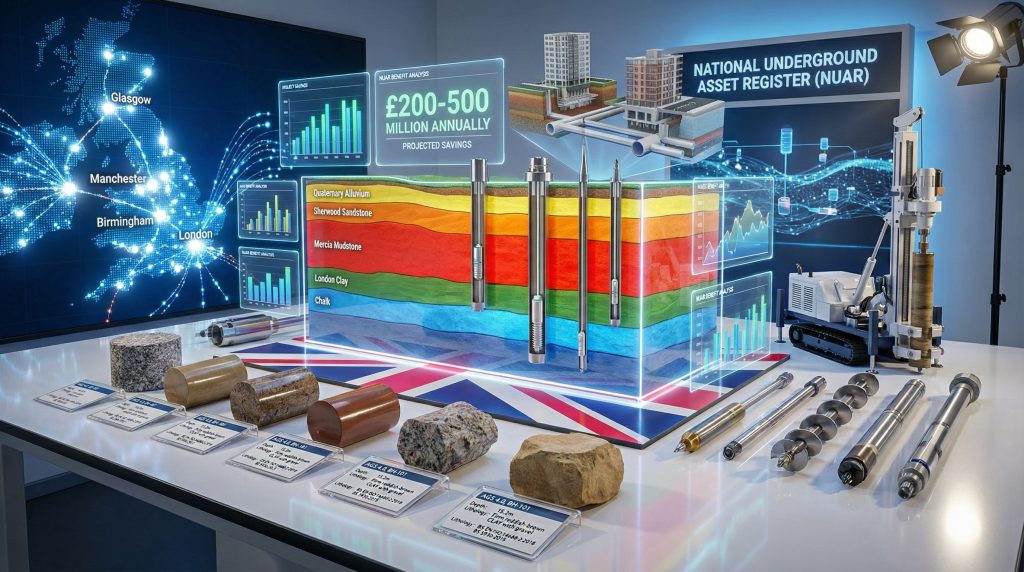
The National Underground Asset Register operates under statutory requirements established through the Health and Safety at Work etc. Act 1974, focusing primarily on utility asset mapping including pipes, cables, and network infrastructure. This framework represents the foundation of the UK's approach to subsurface data management, though its scope has remained limited to buried utility assets since implementation.
Existing Regulatory Structure
The Electronic Communications Code (Access) Regulations 2022 governs utility asset data standardisation and access protocols within the current NUAR framework. However, this regulatory structure creates a significant gap regarding geotechnical information, which encompasses fundamentally different data types and collection methodologies compared to utility asset mapping.
Furthermore, integrating geological logging codes into the proposed framework would establish standardised protocols for recording subsurface conditions. The existing mining claims framework in other jurisdictions demonstrates how regulatory structures can successfully balance commercial interests with public data sharing requirements.
Key regulatory components currently include:
• Mandatory utility asset location data submission
• Standardised access protocols for infrastructure planning
• Quality assurance requirements for asset mapping accuracy
• Commercial licensing frameworks for data access rights
The proposed expansion of NUAR's remit represents the first major broadening of regulatory scope since the system's initial implementation. This expansion acknowledges that subsurface infrastructure planning requires integration of both utility assets and geological conditions to achieve optimal development outcomes.
Parliamentary Process and Implementation Timeline
The parliamentary procedure for advancing the UK geotechnical data bill follows Standing Order No. 23 protocols, which enable individual MPs to propose legislation for consideration. Mike Reader MP, representing Northampton South, secured agreement for his motion in March 2026, establishing the legislative foundation for mandatory geotechnical data sharing.
The bill's second reading has been scheduled for Friday, 17 April 2026, creating a four-week timeline between initial motion agreement and formal parliamentary debate. This parliamentary schedule reflects the procedural requirements for private members' bills, which must demonstrate public interest and cross-party support to advance through the legislative process.
Critical parliamentary milestones include:
• Motion agreement: March 2026 (Standing Order No. 23)
• Second reading debate: 17 April 2026
• Committee stage: Timeline pending parliamentary business
• Third reading: Date to be determined following committee review
• Royal Assent: Projected implementation subject to parliamentary approval
When big ASX news breaks, our subscribers know first
Economic Impact of Current Data Fragmentation
The economic consequences of fragmented geotechnical data practices extend across multiple sectors of the UK construction industry. When ground investigation information remains inaccessible between projects, developers must commission duplicate investigations, creating substantial unnecessary expenditure and project delays.
Quantifying Market Inefficiencies
Reader's parliamentary motion specifically identified the scale of this inefficiency, stating that ground investigation data is collected in vast quantities every year across the UK at great public expense. The fundamental problem lies in data being commercially locked away, lost between projects, or simply duplicated because previous investigations cannot be accessed by subsequent developers.
This fragmentation creates measurable economic impacts through several mechanisms. In addition, modern downhole geophysics techniques offer sophisticated data collection capabilities that could be leveraged more effectively through centralised data sharing systems.
Direct cost implications:
• Duplicate site investigation procurement across overlapping geographic areas
• Mobilisation costs for drilling equipment and personnel
• Laboratory testing expenses for soil and rock analysis
• Professional fees for geotechnical reporting and interpretation
Indirect economic consequences:
• Project delays due to unforeseen ground conditions
• Planning application processing delays
• Risk premium increases for construction financing
• Suboptimal foundation design due to incomplete subsurface knowledge
Infrastructure Development Bottlenecks
The UK's ambitious infrastructure targets create additional urgency around data optimisation. Reader's motion specifically referenced the government's commitment to building 1.5 million homes, reinforcing the electrical grid, strengthening water infrastructure, and delivering clean energy projects.
These objectives require coordinated understanding of subsurface conditions across multiple development sites and infrastructure corridors. When geotechnical data remains fragmented, nationally significant infrastructure projects face avoidable surprises and delays during construction. These delays compound across interconnected infrastructure systems, creating cascading effects on project delivery timelines and cost management.
Technical Standards and Data Collection Requirements
The proposed legislation would mandate specific data categories for submission to the expanded NUAR system, focusing on four primary information types: borehole records, site investigation reports, soil and rock classifications, and groundwater data. This approach balances comprehensive data capture with practical implementation feasibility.
Mandatory Data Categories and Format Specifications
Borehole Records Requirements:
The legislation proposes detailed documentation standards for subsurface drilling activities, building upon existing British Standards (BS 5930) protocols. These requirements would encompass depth intervals, geological descriptions, sample retrieval methods, and groundwater observations collected during site investigations.
Soil Classification Standards:
Data submissions would align with BS EN ISO 14688 specifications for soil identification and classification. This standardisation ensures consistency across particle size distribution analysis, plasticity characteristics, density measurements, and strength parameter documentation where laboratory testing has been conducted.
Rock Core Analysis Documentation:
Documentation requirements would follow BS 5930 guidelines for rock core analysis, including recovery percentages, Rock Quality Designation (RQD) measurements, fracture frequency assessment, weathering classification, and strength evaluation through uniaxial compressive strength testing where applicable.
Groundwater Information Protocols:
Groundwater data submission would incorporate British Geological Survey schema recommendations for water level monitoring, quality assessment, and flow rate documentation. This information proves critical for construction planning, environmental assessment, and long-term site management strategies.
Quality Assurance and Verification Framework
The proposed system would implement comprehensive quality control mechanisms to ensure data accuracy and reliability. These frameworks would build upon existing industry practices while creating standardised protocols for data validation and error correction.
Data verification components would include:
• Third-party validation: Independent review by parties not involved in primary data collection
• Laboratory accreditation verification: Confirmation of UKAS accreditation for analytical services
• Professional credentials validation: Verification of contractor qualifications and professional indemnity insurance
• Audit trail documentation: Timestamped records of data submissions and modifications
• Error reporting mechanisms: Standardised procedures for identifying and correcting data inaccuracies
The legislation deliberately limits initial implementation to forward-going data collection rather than extensive retrospective uploads. This pragmatic approach reduces implementation costs while establishing the foundation for comprehensive future data capture.
Data Access Rights and Commercial Protections
Balancing public benefit with commercial confidentiality represents a critical challenge in designing the expanded data sharing system. The proposed framework must provide meaningful access for infrastructure planning while protecting legitimate commercial interests and intellectual property rights.
Stakeholder Access Hierarchy
The access framework would likely establish hierarchical permissions reflecting different stakeholder needs and public policy priorities. Public sector infrastructure planning would receive priority access to support strategic development objectives, while commercial developers would access data through licensing agreements.
Proposed access tiers:
• Tier 1: Central government infrastructure projects including highways, railways, and utilities
• Tier 2: Local government planning applications and development control functions
• Tier 3: Commercial developers and construction contractors
• Tier 4: Academic institutions and research organisations
This hierarchical structure recognises that public infrastructure planning requires comprehensive subsurface knowledge to optimise resource allocation and minimise development risks. Academic access provisions would support research initiatives that enhance understanding of geological processes and construction methodologies.
Commercial Sensitivity and Intellectual Property Protections
The legislation must address legitimate concerns about protecting commercially sensitive investigation methodologies and project-specific information that could disadvantage data contributors in competitive markets. These protections would likely include time-delayed release mechanisms and anonymisation protocols for sensitive project data.
Commercial protection mechanisms:
• Proprietary methodology safeguards: Protection for innovative investigation techniques and analytical approaches
• Time-delayed access: Staged release of commercially sensitive information following predetermined timeframes
• Project anonymisation: Removal of project-specific identifiers for competitive developments
• Appeals procedures: Formal processes for resolving data access disputes
International Benchmarking and Best Practice Analysis
The UK's approach to mandating geotechnical data sharing reflects broader international trends toward comprehensive subsurface information management. Several countries have implemented similar frameworks that provide valuable insights into effective implementation strategies and potential challenges.
Netherlands Subsurface Information System (BRO)
The Netherlands established mandatory subsurface data submission requirements in 2018 through the Basis Registratie Ondergrond (BRO) system. This comprehensive framework requires submission of geological, geotechnical, and environmental data collected during ground investigations across the country.
Key features of the Dutch system:
• Mandatory participation: Legal requirements for data submission by investigation contractors
• Public-private governance: Collaborative management between government agencies and industry stakeholders
• Technical standardisation: Unified data formats and quality control protocols
• Open access principles: Public availability of aggregated geological information
The Dutch implementation demonstrates that mandatory geotechnical data sharing can achieve significant benefits for infrastructure planning while maintaining commercial viability for investigation contractors. Five years of operation have generated measurable improvements in project planning efficiency and reduced duplicate investigation costs.
Nordic Country Frameworks
Norway, Sweden, and Denmark have each developed distinct approaches to subsurface data management that reflect national priorities and regulatory structures. These systems provide comparative insights into different governance models and implementation strategies.
Norway's geological data sharing framework emphasises environmental site investigation protocols, particularly for contaminated land assessment and remediation planning. Sweden's integrated approach combines planning and subsurface data systems to support municipal development control.
Denmark's system focuses on cross-border data harmonisation to support regional infrastructure planning. Comparative analysis reveals:
• Governance diversity: Different public-private partnership structures across countries
• Technical standards variation: National approaches to data formatting and quality control
• Access framework differences: Varying approaches to balancing public benefit and commercial protection
• Implementation timeline variations: Different strategies for phased system deployment
Projected Economic Benefits and Innovation Opportunities
The centralised geotechnical data system promises substantial economic benefits through reduced investigation duplication and enhanced project planning capabilities. These benefits would compound over time as the database develops comprehensive geographic coverage and historical depth.
Infrastructure Development Cost Reductions
Eliminating duplicate ground investigations across overlapping project areas could generate significant annual savings for the UK construction industry. When developers can access existing geotechnical data for nearby sites, investigation scope and costs can be optimised based on proven subsurface conditions rather than starting from zero knowledge.
Primary cost reduction mechanisms:
• Reduced investigation scope: Targeted drilling programmes based on existing regional knowledge
• Accelerated planning processes: Faster processing of applications with comprehensive ground condition documentation
• Risk mitigation: Reduced construction contingencies due to improved subsurface understanding
• Optimised foundation design: More efficient structural solutions based on detailed ground parameters
Technology and Innovation Advancement
A comprehensive national geotechnical database would create unprecedented opportunities for technological innovation in construction planning and geological analysis. Machine learning applications could identify subsurface patterns and correlations that improve predictive modelling capabilities for future projects.
Innovation opportunities include:
• Predictive ground modelling: AI-driven analysis of geological patterns and construction performance
• Automated risk assessment: Digital tools for evaluating site-specific construction challenges
• Enhanced geological hazard mapping: Improved understanding of landslide, subsidence, and flood risks
• Sustainable material sourcing: Identification of suitable construction aggregate resources
The database would support research initiatives that enhance understanding of UK geological conditions and their implications for construction practices. This research foundation could drive innovations in foundation design, ground improvement techniques, and environmental remediation strategies.
The next major ASX story will hit our subscribers first
Integration with National Digital Infrastructure Strategy
The UK geotechnical data bill aligns with broader UK government initiatives to modernise infrastructure planning and delivery through digital technologies. This integration reflects recognition that effective infrastructure development requires comprehensive data integration across multiple technical domains.
Building Information Modelling (BIM) Integration
The UK government's Level 2 BIM requirements for public sector projects create natural synergies with centralised geotechnical data management. When subsurface information is readily accessible through standardised formats, it can be seamlessly integrated into BIM workflows for design and construction planning.
However, successful implementation requires coordination with emerging data-driven mining operations technologies that demonstrate how comprehensive data integration can transform industry practices. BIM integration benefits:
• Enhanced design coordination: Better integration between foundation design and structural engineering
• Improved cost estimation: More accurate quantity surveying based on ground condition knowledge
• Construction sequencing optimisation: Better planning of earthworks and foundation activities
• Asset management integration: Long-term maintenance planning incorporating subsurface conditions
Open Data and Transparency Commitments
The legislation supports government commitments to open data principles and transparency in public infrastructure planning. By making geotechnical information more accessible, the system enhances democratic accountability and public understanding of infrastructure development decisions.
Government Digital Service design principles emphasise user-centred design, data portability, and interoperability standards that would inform the technical implementation of the expanded NUAR system. These principles ensure that the geotechnical database serves diverse user needs while maintaining technical excellence and security standards.
Climate Change and Environmental Implications
The comprehensive geotechnical database would support UK climate change adaptation and net zero objectives through enhanced understanding of subsurface conditions relevant to low-carbon infrastructure development and environmental resilience planning.
Renewable Energy Infrastructure Support
Geothermal energy development requires detailed understanding of subsurface temperature profiles, groundwater flow patterns, and geological formations suitable for heat extraction. The geotechnical database would compile information relevant to identifying optimal locations for ground source heat pump installations and deeper geothermal energy projects.
Carbon capture and storage initiatives depend on geological formations capable of long-term CO2 containment. Comprehensive subsurface characterisation supports site evaluation and risk assessment for these climate change mitigation technologies.
Furthermore, sustainable mining practices demonstrate how comprehensive environmental data integration can support both resource extraction and environmental protection objectives.
Environmental Resilience and Flood Management
Climate change adaptation requires enhanced understanding of ground conditions affecting flood risk management and sustainable drainage system performance. Geotechnical data supports modelling of groundwater behaviour, soil infiltration rates, and subsurface infrastructure vulnerability to extreme weather events.
Environmental applications include:
• Flood risk assessment: Understanding of soil permeability and groundwater patterns
• Sustainable drainage design: Optimisation of infiltration-based stormwater management
• Coastal erosion analysis: Geological factors affecting shoreline stability and protection strategies
• Landslide risk mapping: Identification of slope stability challenges under changing precipitation patterns
Implementation Challenges and Risk Mitigation Strategies
Despite substantial potential benefits, implementing mandatory geotechnical data sharing presents significant technical, commercial, and organisational challenges that require careful planning and stakeholder engagement.
Technical Infrastructure Development
Creating a national-scale geotechnical database requires substantial technical infrastructure investment and ongoing operational capacity. The system must handle diverse data formats, ensure long-term data preservation, and provide reliable access across multiple user categories.
Technical requirements include:
• Database capacity planning: Storage and processing capabilities for national geotechnical data volumes
• API development: Integration protocols for third-party software and analysis tools
• Cybersecurity frameworks: Protection of infrastructure-sensitive information
• Data migration protocols: Procedures for incorporating existing datasets
Industry Adaptation and Training Requirements
The legislation would require significant adaptations across the geotechnical investigation industry, including software upgrades, procedural changes, and professional development initiatives. Small and medium enterprises may face particular challenges in adapting to new technical requirements and compliance obligations.
Industry support measures:
• Professional development programmes: Training for geotechnical practitioners on new data standards
• Software compatibility initiatives: Support for industry adoption of compatible data management systems
• Transition period provisions: Phased implementation to allow industry adaptation
• SME support programmes: Financial and technical assistance for smaller investigation contractors
The success of the UK geotechnical data bill ultimately depends on effective collaboration between government, industry, and academic stakeholders to create a system that serves public objectives while maintaining commercial viability for data contributors. Moreover, successful implementation could position the UK as a global leader in infrastructure data management, demonstrating how legislative frameworks can balance public benefit with commercial interests.
This analysis is based on publicly available information regarding parliamentary proceedings and industry practice. Readers should consult official government sources and professional advisors for specific implementation details and compliance requirements.
Ready to Capitalise on Infrastructure Development Opportunities?
The UK's transformative approach to geotechnical data management creates unprecedented opportunities for informed investors tracking infrastructure and mining developments. Discovery Alert's proprietary Discovery IQ model delivers real-time alerts on significant ASX mineral discoveries, instantly empowering subscribers to identify actionable opportunities ahead of the broader market whilst regulatory changes reshape data accessibility across sectors. Begin your 14-day free trial today and secure your market-leading advantage.