May 21, 2026
Revolutionizing Uranium Discovery Through Advanced Satellite-Enabled Geophysics
The convergence of satellite technology and subsurface imaging represents a paradigm shift in mineral exploration methodologies. Traditional geophysical surveys face increasing limitations in complex terrain environments, where conventional line-based methods cannot access critical geological structures. This technological evolution addresses fundamental exploration challenges through real-time data processing, wireless sensor networks, and three-dimensional subsurface visualization capabilities that transform how explorers identify and evaluate uranium mineralization targets.
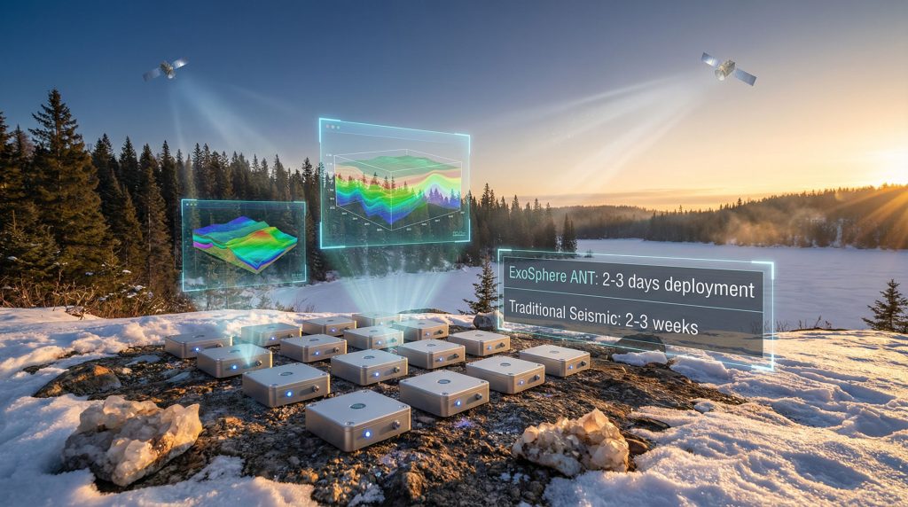
Modern exploration demands require innovative solutions that minimize environmental impact while accelerating target identification timelines. Fleet Space Technologies' ExoSphere platform exemplifies this technological advancement, combining ambient noise tomography with satellite connectivity to deliver subsurface intelligence in previously inaccessible areas. The system's deployment at Fermi Exploration's Perch River property demonstrates practical applications in tier-one uranium districts, where ExoSphere guides uranium drilling programs toward high-priority targets through advanced structural delineation.
When big ASX news breaks, our subscribers know first
Understanding Fleet Space Technologies' Revolutionary Subsurface Imaging Platform
ExoSphere technology integrates multiple advanced geophysical principles within a satellite-enabled data processing framework. The system employs ambient noise tomography (ANT) methodologies using natural seismic energy sources, eliminating requirements for active energy generation typical in conventional seismic surveys. Furthermore, wireless Geode sensors capture subsurface velocity variations across frequency ranges optimized for structural mapping at uranium exploration depths.
Fermi Exploration's recent implementation showcases how ExoSphere guides uranium drilling through enhanced target identification. Consequently, this approach significantly improves exploration efficiency compared to traditional methods.
ExoSphere vs Traditional Geophysical Methods
| Method | Deployment Speed | 3D Capability | Satellite Integration | Real-time Processing |
|---|---|---|---|---|
| ExoSphere ANT | 2-3 days | Yes | Full satellite uplink | Yes |
| Traditional Seismic | 2-3 weeks | Limited | No | No |
| Ground Gravity | 1-2 weeks | No | No | No |
| Magnetic Surveys | 1 week | Limited | No | No |
The platform's low-Earth-orbit satellite constellation enables real-time data transmission from field sensors to cloud-based processing systems. This architecture eliminates on-site computational infrastructure requirements while providing immediate access to 3D geological modeling capabilities. Fleet Space Technologies' CEO Flavia Tata Nardini emphasizes that this approach delivers subsurface intelligence in complex geological environments, helping identify critical structures earlier while reducing environmental impact compared to traditional methods.
Cloud-based modeling capabilities generate visualization products within hours of data collection, representing significant timeline improvements over conventional workflows. The system processes ambient seismic noise through machine learning algorithms designed to identify velocity anomalies associated with geological structures relevant to uranium exploration. In addition, integration with existing geological datasets enhances interpretation accuracy through multi-dataset correlation and validation.
Satellite Data Transmission Architecture
Fleet Space Technologies operates a constellation of small satellites positioned in low-Earth orbit for continuous data relay capabilities. The satellite network receives encrypted transmissions from field-deployed Geode sensors, ensuring data security through redundant communication pathways. This transmission system eliminates physical data retrieval requirements typical in conventional geophysical surveys, enabling real-time project monitoring and interpretation.
Processing infrastructure utilizes cloud-based computing resources for velocity inversion calculations and three-dimensional model generation. The system's machine learning components analyze ambient noise patterns to distinguish geological structures from background seismic activity. Moreover, quality control algorithms validate data integrity throughout transmission and processing workflows, maintaining interpretation confidence levels required for drilling target selection.
What Makes Ambient Noise Tomography Superior for Uranium Detection?
Ambient noise tomography leverages naturally occurring seismic energy from ocean wave activity and atmospheric disturbances as the primary data source. This passive methodology eliminates active energy source requirements while providing continuous subsurface sampling throughout deployment periods. The technique measures Rayleigh wave dispersion characteristics across sensor arrays to generate velocity models reflecting geological structure variations.
Physics-Based Subsurface Mapping
Natural seismic noise propagation through subsurface materials creates velocity signatures corresponding to rock properties, structural features, and alteration zones. ExoSphere guides uranium drilling through sensors that record ambient vibrations across frequency ranges optimized for uranium exploration depths, typically extending to five kilometers below surface. Machine learning algorithms process these velocity variations to identify anomalous zones potentially associated with uranium mineralization environments.
• Utilizes continuous natural seismic energy sources
• Wireless sensor networks eliminate cable connectivity requirements
• Penetration depths reaching 5 kilometers below surface
• Real-time velocity inversion through cloud processing
• Integration capabilities with existing geophysical datasets
Real-Time Satellite Data Transmission
Low-Earth-orbit satellite connectivity provides immediate data access throughout survey deployment periods. Field sensors transmit encrypted geophysical measurements directly to orbiting platforms, bypassing traditional data storage and physical retrieval methods. However, cloud-based processing generates three-dimensional velocity models within hours of data collection, enabling real-time interpretation and target refinement.
• Instantaneous data relay from field sensors to processing centers
• Encrypted transmission protocols ensure data security
• Cloud-based visualization eliminates on-site computational requirements
• Integration with geological databases through AI in drilling & blasting analysis algorithms
• Quality control validation maintains interpretation accuracy standards
Technical Parameters for Uranium Exploration
| Specification | Value | Application |
|---|---|---|
| Sensor Array Spacing | 50-200m | Optimal resolution for uranium targets |
| Recording Duration | 24-72 hours | Sufficient ambient noise capture |
| Frequency Range | 0.1-50 Hz | Structural mapping at exploration depths |
| Data Transmission | Real-time satellite | Immediate processing capability |
| Processing Time | 2-6 hours | Rapid target identification |
Why Are Structural Corridors Critical for Uranium Mineralization?
Unconformity-hosted uranium deposits form through complex hydrothermal processes requiring specific geological conditions for economic mineralization. Structural features provide essential pathways for uranium-bearing fluid movement and create favorable chemical environments for precipitation reactions. The Athabasca Basin exemplifies this geological model, where fault systems control high-grade uranium accumulation through redox boundary interactions, similar to what's being explored at the Patterson Corridor uranium project.
Geological Prerequisites for Uranium Deposits
Fault systems create high-permeability conduits enabling hydrothermal fluid circulation through otherwise impermeable rock sequences. These structural features focus fluid flow along specific pathways where oxidized groundwater encounters reduced host rocks, triggering uranium precipitation through redox chemistry. Unconformity contacts represent critical interfaces where contrasting rock types and oxidation states facilitate uranium deposition.
• Fault networks provide fluid pathways through fractured rock
• Unconformity surfaces create redox boundaries for uranium precipitation
• Alteration zones indicate historical hydrothermal fluid activity
• Radiogenic isotope signatures confirm uranium accumulation processes
• Structural complexity enhances fluid mixing and mineralization potential
The Athabasca Basin hosts some of the world's highest-grade uranium deposits, with mineralization controlled by structural corridors that focus hydrothermal fluid flow along fault systems intersecting the unconformity surface. These geological conditions create optimal environments for uranium precipitation and accumulation.
Structural Controls on Uranium Deposition
Unconformity-hosted uranium deposits require structural preparation through tectonic processes that create permeability networks within otherwise tight rock sequences. Fault zones provide both pathways for fluid circulation and areas of mechanical weakness where hydrothermal alteration can proceed effectively. Furthermore, the intersection of multiple structural trends often creates complex permeability networks optimal for sustained fluid flow and uranium accumulation.
Physical alteration associated with structural zones includes brecciation, fracturing, and mineral replacement reflecting hydrothermal fluid interaction. Clay mineral assemblages, iron oxide phases, and silica precipitation features indicate redox conditions favorable for uranium deposition. These alteration signatures extend beyond immediate fault zones, creating exploration targets identifiable through geophysical and geochemical methods.
Radiogenic isotope characteristics provide direct evidence of uranium accumulation within structural corridors. Lead isotope signatures reflect uranium decay processes and help distinguish uranium-related anomalies from background geological signatures. Consequently, radon emanation patterns often outline structural permeability networks where uranium mineralization has occurred, creating surface geochemical signatures useful for exploration targeting.
How Does ExoSphere Address Traditional Exploration Challenges?
Conventional geophysical surveys face significant limitations in complex terrain environments where continuous line-based measurements become impractical or impossible. River channels, wetlands, steep topography, and dense vegetation prevent traditional seismic survey deployment while potentially concealing critical geological structures. For instance, ExoSphere guides uranium drilling programs by providing complete subsurface coverage regardless of surface terrain complexity through wireless sensor technology that overcomes these accessibility constraints.
Terrain and Access Limitations
Traditional seismic surveys require continuous sensor lines with regular spacing intervals, creating significant logistical challenges in areas with natural obstacles. River channels, marshlands, and steep terrain often prevent conventional survey completion or create data gaps that compromise structural interpretation. However, this advanced technology provides complete subsurface coverage regardless of surface terrain complexity.
• Wireless sensor networks eliminate physical connectivity requirements
• Helicopter deployment enables access to previously inaccessible areas
• Flexible array geometries adapt to terrain constraints
• Remote data collection reduces field crew safety risks
• Complete subsurface coverage maintains interpretation quality
Cost and Time Efficiency Improvements
ExoSphere deployment timelines represent significant improvements over traditional geophysical methods, reducing survey completion from weeks to days. Equipment transportation requirements decrease substantially through wireless sensor technology and satellite data transmission capabilities. Furthermore, earlier identification of non-prospective areas enables more efficient drilling budget allocation and accelerated project advancement timelines.
Standard Uranium's successful deployment demonstrates these efficiency improvements in practice. Moreover, the technology aligns with current uranium market trends that demand cost-effective exploration solutions.
• Survey completion in 2-3 days versus weeks for conventional methods
• Reduced equipment transportation and mobilization costs
• Earlier drill target identification improves budget efficiency
• Integration capabilities enhance existing geological datasets
• Shorter deployment periods minimize environmental permitting complexity
Deployment Comparison Analysis
| Challenge Area | Traditional Method | ExoSphere Solution |
|---|---|---|
| River Channel Access | Line survey impossible | Wireless deployment across water |
| Equipment Transport | Extensive cable networks | Lightweight wireless sensors |
| Processing Timeline | Weeks to interpretation | Hours to 3D models |
| Environmental Impact | Significant ground disturbance | Minimal surface footprint |
What Are the Technical Specifications of ExoSphere Deployment?
ExoSphere sensor arrays utilize optimized spacing intervals designed specifically for uranium exploration target identification. Sensor placement follows geological considerations rather than rigid geometric patterns, enabling customized array configurations adapted to structural trends and exploration objectives. Recording durations capture sufficient ambient noise data for reliable velocity inversion while maintaining operational efficiency throughout deployment periods.
Multiphysics Integration Capabilities
The platform incorporates Horizontal-to-Vertical Spectral Ratio (HVSR) analysis for enhanced subsurface characterization beyond standard ambient noise tomography methods. This technique measures seismic motion ratios at individual sensor locations, identifying resonance frequencies that reflect subsurface structure characteristics. In addition, integration with ground gravity and magnetic datasets provides comprehensive geological models supporting drilling target selection.
• HVSR analysis enhances structural definition accuracy
• Ground gravity correlation validates density variations
• Magnetic field mapping identifies lithologic contacts
• Geochemical anomaly overlay capabilities
• Multi-dataset integration through AI-driven algorithms
Processing and Interpretation Methodologies
Velocity inversion algorithms process ambient noise dispersion characteristics to generate three-dimensional subsurface models. Machine learning components distinguish geological structures from background seismic noise while identifying velocity anomalies potentially associated with uranium exploration targets. Quality control procedures validate model accuracy through cross-correlation analysis and geological constraint integration.
Low-velocity zones within processed models often indicate structural features relevant to uranium exploration, including fault zones, alteration areas, and permeability networks. These anomalies guide drilling target selection through integration with surface geological mapping, geochemical surveys, and airborne geophysical datasets. However, model uncertainties are quantified and communicated to ensure appropriate confidence levels for exploration decision-making.
The next major ASX story will hit our subscribers first
How Do Exploration Companies Validate ExoSphere Results?
Drilling programs provide direct validation of ExoSphere structural interpretations through core logging and geological observation. Physical evidence of structural features predicted by velocity models confirms interpretation accuracy while establishing confidence levels for future surveys. Furthermore, integration of drill core analysis with geophysical models enhances understanding of subsurface geological relationships relevant to uranium exploration.
Drill Program Integration Methodology
ExoSphere guides uranium drilling through structural models that guide initial drill hole placement toward velocity anomalies interpreted as potential uranium-bearing structures. Core logging documents physical evidence of structural features including fracturing, brecciation, and hydrothermal alteration. Geochemical analysis of drill core samples validates uranium mineralization potential through elemental associations and isotopic characteristics.
- Velocity Model Interpretation: Low-velocity zones identified as structural targets
- Drill Hole Planning: Core hole placement tests structural predictions
- Physical Validation: Core logging confirms predicted structural features
- Geochemical Confirmation: Laboratory analysis validates uranium associations
- Expanded Programming: Additional drilling tests structural continuity
Structural Validation Process
The Perch River project exemplifies successful ExoSphere validation through drilling confirmation of predicted structural features. Initial surveys identified subsurface velocity anomalies beneath a river channel where conventional methods could not operate. Subsequently, drilling confirmed physical alteration, fracturing, and radiogenic isotope anomalies consistent with uranium mineralization indicators within the interpreted Rapids Fault System.
Drill results at Perch River showed zones of rock that had been physically broken and altered by fluid movement, consistent with conditions associated with uranium mineralization. This validation confirms ExoSphere's capability to identify critical structures in challenging terrain environments.
Geochemical validation involves laboratory analysis of drill core samples for uranium-related elemental associations, lead isotope signatures, and alteration mineral assemblages. These analytical results provide quantitative confirmation of uranium exploration potential while supporting structural interpretations derived from velocity models. Follow-up drilling programs test structural continuity along predicted corridors, expanding understanding of mineralization controls.
What Investment Implications Does ExoSphere Technology Present?
Advanced geophysical technologies like ExoSphere provide exploration companies with competitive advantages through accelerated target identification and reduced exploration risk. Earlier recognition of non-prospective areas enables more efficient capital allocation while faster progression from exploration to resource definition enhances project economics. Consequently, investors benefit from improved exploration success rates and enhanced technical presentations supporting funding decisions.
Exploration Risk Reduction
This technology provides comprehensive subsurface intelligence before significant drilling expenditures occur. This early-stage geological understanding reduces uncertainty associated with blind exploration drilling while improving overall project success probabilities. Enhanced structural knowledge enables more confident resource estimation and development planning throughout project advancement stages.
• Earlier identification of non-prospective areas reduces drilling costs
• Higher success rates for initial drill programs improve investor confidence
• Faster progression from exploration to resource definition
• Enhanced technical presentations support funding discussions
• Reduced exploration timeline uncertainty improves project economics
Competitive Advantages for Uranium Explorers
Companies utilizing advanced geophysical technologies gain competitive positioning through access to previously inaccessible geological information. ExoSphere capability in challenging terrain environments enables exploration of areas avoided by conventional survey methods. Technology differentiation supports premium valuations and partnership opportunities within competitive uranium exploration markets.
Integration with existing geological datasets enhances overall project understanding beyond individual survey results. Multi-dataset correlation capabilities provide comprehensive geological models supporting technical due diligence and investment decisions. Moreover, advanced visualization products communicate complex subsurface relationships effectively to technical and non-technical stakeholders throughout funding processes.
How Does ExoSphere Support Sustainable Exploration Practices?
Environmental considerations increasingly influence exploration methodology selection as companies seek to minimize ecological impact while maintaining geological effectiveness. ExoSphere technology reduces environmental footprint through wireless sensor deployment, shorter field operations periods, and elimination of extensive ground preparation requirements. These sustainability benefits align with modern environmental standards and regulatory expectations, supporting broader renewable energy in mining initiatives.
Environmental Impact Minimization
Wireless sensor technology eliminates extensive cable network installation typically required for conventional seismic surveys. Helicopter deployment reduces ground disturbance while providing access to sensitive areas without permanent access road construction. Furthermore, shorter deployment periods minimize wildlife disruption and cumulative environmental impact throughout exploration programs.
• Reduced ground disturbance compared to traditional survey methods
• Wireless technology eliminates extensive cable network requirements
• Shorter field deployment periods minimize wildlife disruption
• Remote operation capabilities reduce personnel transportation needs
• Digital processing eliminates paper-based reporting requirements
Carbon Footprint Reduction
Satellite data transmission eliminates physical data retrieval requirements while reducing equipment transportation demands. Shorter exploration timelines decrease overall project emissions through reduced field operations and equipment mobilization. Cloud-based processing capabilities eliminate on-site power generation requirements typically associated with conventional geophysical data processing.
Remote monitoring and interpretation capabilities reduce personnel travel requirements while maintaining project oversight and technical quality. Digital workflows eliminate physical documentation and reporting systems, contributing to overall sustainability improvements. These environmental benefits support corporate responsibility objectives while maintaining exploration effectiveness standards.
What Future Applications Could ExoSphere Enable?
Technological evolution continues advancing satellite-enabled exploration capabilities through improved processing algorithms, expanded sensor networks, and enhanced integration methodologies. Future applications may include autonomous drilling platform integration for continuous feedback systems and real-time exploration decision-making. Machine learning improvements promise enhanced geological interpretation accuracy through expanded training datasets and pattern recognition capabilities.
Technology Evolution Potential
Integration with autonomous drilling platforms could enable continuous geological feedback throughout drilling operations. Real-time structural model updates based on drill progress would optimize hole placement and trajectory adjustments for maximum geological information recovery. For instance, predictive modeling capabilities may support proactive exploration strategies based on geological pattern recognition and historical success analysis.
• Integration with autonomous drilling systems for continuous feedback
• Machine learning improvements enhance interpretation accuracy
• Expanded sensor networks enable regional-scale structural mapping
• Real-time exploration decisions through predictive modeling
• Pattern recognition algorithms support target prioritization
Industry Adoption Trends
Major mining companies evaluate satellite-enabled exploration technologies for competitive advantages and operational efficiency improvements. Government geological surveys incorporate advanced geophysical methods for regional mapping and resource assessment programs. Academic institutions research ambient noise tomography applications for enhanced understanding of subsurface geological processes.
Technology transfer opportunities extend beyond uranium exploration to other mineral sectors requiring structural control understanding. Base metal, precious metal, and industrial mineral exploration programs may benefit from similar technological approaches adapted to specific geological environments and exploration objectives. This technological diffusion expands market opportunities while advancing overall exploration effectiveness across multiple commodity sectors.
Frequently Asked Questions About ExoSphere Technology
How accurate are ExoSphere structural interpretations compared to traditional methods?
ExoSphere provides comparable accuracy to conventional seismic surveys while offering superior 3D resolution and faster deployment capabilities. Validation through drilling programs consistently confirms structural predictions with high confidence levels. Integration with existing geological datasets enhances interpretation accuracy beyond individual survey methods.
What geological environments are most suitable for ExoSphere deployment?
The technology performs optimally in sedimentary basins, particularly unconformity-hosted uranium districts where structural controls influence mineralization. Complex terrain environments benefit most from wireless sensor capabilities, including areas with significant topographic relief, water coverage, or access limitations preventing conventional surveys.
How does satellite data transmission ensure data security and integrity?
Fleet Space Technologies employs encrypted satellite communication protocols with redundant data transmission pathways. Cloud-based processing includes backup systems and data verification algorithms to maintain information integrity throughout processing workflows. Quality control procedures validate data accuracy and completeness before interpretation and modeling.
What are the typical costs associated with ExoSphere deployment?
Deployment costs vary based on survey area size, sensor array density, and logistical requirements. However, total project costs often decrease through reduced drilling expenditures and faster target identification timelines. Earlier recognition of non-prospective areas enables more efficient capital allocation throughout exploration programs.
How long does ExoSphere data processing typically require?
Processing timelines range from 2-6 hours for initial velocity models, with comprehensive interpretation products available within days of data collection completion. Real-time processing capabilities enable immediate quality control and preliminary interpretation during survey deployment periods.
Transforming Uranium Exploration Through Advanced Geophysics
ExoSphere technology represents a fundamental advancement in mineral exploration methodology, combining satellite connectivity with sophisticated subsurface imaging to accelerate uranium discovery processes. As global uranium demand increases for clean energy applications, exploration companies require innovative technologies that reduce risk, minimize environmental impact, and improve discovery success rates while operating in increasingly challenging geological environments.
The integration of ambient noise tomography with real-time satellite processing creates unprecedented opportunities for exploring complex terrain while maintaining cost-effective operational parameters. For uranium explorers operating in premier districts like the Athabasca Basin, this technology provides enhanced geological understanding and faster target identification capabilities that provide significant competitive advantages in dynamic exploration markets.
This technological evolution addresses fundamental limitations of conventional geophysical methods while supporting sustainable exploration practices aligned with modern environmental standards. The successful validation at projects like Perch River demonstrates practical applications in tier-one uranium districts, where structural delineation capabilities directly support drilling success and resource development timelines. As satellite-enabled exploration technologies continue advancing, ExoSphere represents a transformative approach to uranium discovery that enhances both exploration effectiveness and environmental stewardship throughout the exploration process.
Disclaimer: This article contains forward-looking statements and speculative analysis based on available technical information. Exploration results and technology performance may vary based on geological conditions and deployment parameters. Investment decisions should consider comprehensive technical and financial analysis beyond technological capabilities alone.
Interested in the Next Major Uranium Discovery?
Discovery Alert instantly notifies investors of significant ASX uranium discoveries using its proprietary Discovery IQ model, turning complex mineral data into actionable insights just as ExoSphere guides uranium drilling through advanced technology. Explore Discovery Alert's discoveries page to understand how historic mineral discoveries have generated substantial returns, then begin your 30-day free trial to position yourself ahead of the market in this rapidly evolving uranium exploration sector.