May 19, 2026
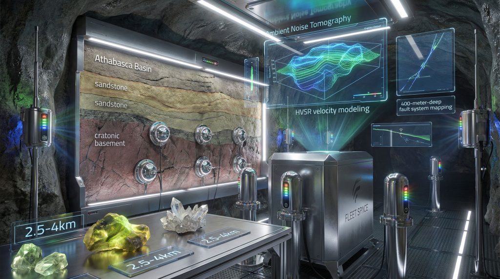
The global uranium sector faces mounting pressure to identify high-grade deposits while minimising environmental disruption. Traditional exploration methods struggle with the geological complexity of unconformity-related deposits, particularly in regions like Canada's Athabasca Basin where mineralisation occurs at significant depths within narrow structural corridors. Advanced multiphysics platforms represent a fundamental shift toward data-driven mining operations that can identify critical mineral deposits with unprecedented precision.
Fleet Space's ExoSphere platform demonstrates how integrated sensor technologies are transforming uranium exploration through real-time subsurface imaging capabilities. This technological approach addresses fundamental challenges in detecting deep-seated deposits by combining passive seismic surveys with gravity and magnetic data to create comprehensive three-dimensional models of subsurface structures. Furthermore, the Fleet Space ExoSphere platform for uranium exploration represents a significant advancement in exploration technology.
What Makes ExoSphere Different from Traditional Uranium Exploration Methods?
Real-Time 3D Subsurface Imaging Capabilities
The Fleet Space ExoSphere platform for uranium exploration utilises Ambient Noise Tomography (ANT) technology to overcome limitations of conventional line-based geophysical surveys. At the Perch River project in Saskatchewan's Athabasca Basin, traditional geophysical methods were impossible to deploy due to a 100-meter-wide river crossing the target area. ExoSphere's modular deployment approach identified a 400-meter-deep subvertical low-velocity corridor without requiring extensive surface clearing or linear survey grids.
This capability proves particularly valuable in structurally complex environments where uranium mineralisation follows irregular patterns. The technology integrates passive seismic data with ground gravity and magnetic survey results to eliminate traditional survey limitations while providing comprehensive structural mapping capabilities. In addition, these advancements align with broader mining innovation trends transforming the sector.
Addressing Unconformity-Related Uranium Detection Challenges
Unconformity-related uranium deposits present unique exploration challenges due to their narrow geometries, deep settings, and irregular alteration systems. These deposits typically occur at depths between 200-1,200 metres below surface, often within fault structures or at unconformities between cratonic basement rocks and younger sedimentary sequences.
The ExoSphere platform addresses these challenges through:
- Deep structural mapping capabilities extending to 400+ metre depths
- Detection of narrow geometry deposits in complex geological environments
- Identification of irregular alteration system patterns through velocity modelling
- Real-time imaging of major structural zones for improved drill targeting
At Perch River, the platform identified the Rapids Fault System as a critical structural feature. Subsequent drilling validated this through discovery of intense alteration zones containing radiogenic lead signatures characteristic of uranium mineralisation environments.
When big ASX news breaks, our subscribers know first
Technical Architecture Behind ExoSphere's Multiphysics Approach
Core Sensor Technologies and Data Integration
The Fleet Space ExoSphere platform for uranium exploration integrates multiple geophysical datasets to create comprehensive subsurface models. The Perch River case study demonstrates integration of:
Primary Data Sources:
- Passive seismic survey data through ANT technology
- Ground gravity survey measurements with density mapping
- High-resolution magnetic survey results
- Lead isotope geochemistry analysis
- Soil geochemistry vectors
- Radon sampling measurements
This multiphysics approach enables identification of structural features that single-method surveys might miss. The platform processes ambient seismic noise to generate velocity models of subsurface structures, while gravity data provides density contrasts that highlight geological boundaries and fault systems. Moreover, this integration supports improved drilling results interpretation across exploration projects.
Processing Algorithms for Structural Feature Recognition
Advanced processing capabilities enable the ExoSphere platform to identify low-velocity zones associated with structural features and hydrothermal alteration. At Perch River, the system identified a deep low-velocity zone termed the Rapids Fault System. Drilling subsequently validated this as a zone of intense chlorite-hematite alteration with significant shearing, fracturing, and brecciation.
Key Processing Capabilities:
- Low-velocity zone identification through ambient noise analysis
- Structural corridor characterisation using integrated geophysics
- Hydrothermal alteration signature recognition through velocity anomalies
- Real-time data processing for immediate targeting decisions
| Parameter | ExoSphere Platform | Traditional Methods |
|---|---|---|
| Data Collection Speed | Real-time 3D imaging | Sequential line surveys |
| Environmental Impact | Minimal surface disturbance | Extensive grid clearing |
| Structural Resolution | Sub-vertical corridor mapping | Broad regional trends |
| Deployment Flexibility | Modular sensor placement | Fixed grid requirements |
How Does ExoSphere Identify High-Priority Uranium Targets?
Geological Signature Recognition in the Athabasca Basin
The Athabasca Basin represents one of the world's premier uranium provinces, hosting unconformity-related deposits within structurally complex environments. ExoSphere identifies high-priority targets by mapping fault structure pathways that serve as migration routes for uranium-bearing hydrothermal fluids.
At Perch River, the platform identified structural architecture coincident with prior soil geochemistry anomalies and proximal to the regional Font du Lac Fault system. This structural targeting approach guided drill hole placement into zones containing:
- Radiogenic Lead Signatures: ²⁰⁶Pb/²⁰⁴Pb ratios up to 242.8 and ²⁰⁷Pb/²⁰⁶Pb ratios of 0.15
- Intense Alteration Zones: Pervasive chlorite-hematite alteration between 287.9-322.5 metres downhole
- Structural Features: 100-metre interval of intense shearing and brecciation
Integration with Geochemical and Isotopic Data
The Fleet Space ExoSphere platform for uranium exploration validates structural targets through integration with established geochemical vectors. Lead isotope signatures provide critical confirmation of uranium-related hydrothermal processes, as radiogenic lead isotopes are characteristic indicators of uranium mineralisation systems.
Integrated Targeting Approach:
- Initial soil and radon sampling identifies geochemical anomalies
- Magnetic and gravity surveys indicate potential structural features
- ExoSphere passive seismic imaging maps deep structural corridors
- Geochemical validation confirms radiogenic signatures
- Targeted drilling tests integrated exploration model
This systematic approach increases confidence in drill targeting while reducing exploration risks through multi-dataset validation of prospective zones. Consequently, AI transforming drilling techniques are becoming increasingly important in optimising these processes.
What Are the Operational Advantages for Exploration Companies?
Cost-Effectiveness and Time Reduction
Traditional uranium exploration often requires extensive surface preparation and sequential survey methods that can be time-consuming and environmentally disruptive. The ExoSphere platform reduces operational costs through improved targeting precision and reduced drilling uncertainty.
At Perch River, the integrated approach enabled focused drilling based on validated structural targets. Drill hole PR25_04A successfully intersected the ExoSphere-identified low-velocity zone. This precision targeting approach can significantly reduce the number of exploratory holes required to test geological models.
Operational Benefits:
- Reduced drilling uncertainty through validated structural targeting
- Lower environmental impact compared to traditional line-based surveys
- Accelerated decision-making through real-time data processing
- Enhanced confidence in geological models before drilling
Scalability Across Multiple Project Sites
The modular design of ExoSphere enables deployment across diverse geological environments and project scales. This scalability proves particularly valuable for exploration companies managing multiple properties within uranium districts like the Athabasca Basin.
The deployment of advanced geophysical platforms represents a fundamental shift toward data-driven exploration strategies that can identify critical mineral deposits with unprecedented precision while minimising environmental disruption.
Fleet Space CEO Flavia Tata Nardini emphasises that this approach accelerates the path to discovery in tier-one mineral districts. Furthermore, it strengthens the resilience of global mineral supply chains when secure access to uranium and strategic resources is increasingly vital for clean energy systems.
Case Study Analysis: Perch River Discovery Validation
Structural Corridor Identification Success
The Perch River project demonstrates successful application of integrated geophysical targeting in a challenging geological environment. Previous soil sampling had identified anomalous uranium, nickel, lead isotopes, and rare earth elements alongside locally elevated radon concentrations.
ExoSphere Deployment Results:
- Structural Feature: 400-metre-deep subvertical low-velocity corridor
- Validation Drilling: Hole PR25_04A intersected intense alteration zone
- Alteration Characteristics: Chlorite-hematite alteration with structural overprint
- Geochemical Confirmation: Radiogenic lead signatures within low-velocity zone
Technical Validation Through Drilling
Drill hole PR25_04A provided crucial validation of the ExoSphere-identified Rapids Fault System. The hole intersected a 100-metre interval containing intense alteration and strongly radiogenic lead isotope signatures. These signatures are consistent with those observed near uranium mineralisation in the Athabasca Basin.
| Project Component | Perch River Results | Validation Method |
|---|---|---|
| Structural Depth | 400m subvertical corridor | Drilling intersection |
| Alteration Zone | 287.9-322.5m interval | Core logging analysis |
| Lead Isotopes | ²⁰⁶Pb/²⁰⁴Pb = 242.8 | Laboratory analysis |
| Structural Complexity | Intense shearing/brecciation | Geological observation |
How Does ExoSphere Support Sustainable Mining Practices?
Environmental Impact Minimisation
The Fleet Space ExoSphere platform for uranium exploration significantly reduces environmental disruption compared to traditional exploration methods. Conventional line-based geophysical surveys often require extensive clearing of vegetation and creation of access roads across survey grids.
ExoSphere's modular deployment eliminates these requirements through:
- Reduced Surface Disturbance: No requirement for extensive grid clearing
- Lower Carbon Footprint: Efficient data collection reduces field time
- Ecosystem Protection: Minimal disruption in environmentally sensitive areas
- Water Body Navigation: Surveys possible across rivers and wetlands
Resource Efficiency and Waste Reduction
Precision targeting capabilities reduce unnecessary drilling and associated waste generation. By providing validated structural targets before drilling, exploration companies can optimise their programmes to focus on high-probability zones. This approach replaces extensive reconnaissance drilling programmes.
This method enhances resource recovery planning by identifying the most prospective structural corridors early in the exploration process. Consequently, it enables more efficient allocation of exploration capital whilst reducing overall project environmental footprint. However, companies must also consider mining sustainability transformation practices throughout their operations.
The next major ASX story will hit our subscribers first
What Are the Technical Limitations and Future Development Areas?
Current Operational Constraints
While ExoSphere demonstrates significant capabilities, certain technical constraints affect deployment and application. Weather conditions and extreme terrain can impact sensor deployment and data quality, particularly in remote locations characteristic of many uranium exploration projects.
Current Limitations:
- Optimal performance requires suitable ground conditions for sensor placement
- Data processing complexity requires specialised technical expertise
- Integration with existing exploration datasets requires systematic workflow development
- Performance may vary in different geological environments beyond the Athabasca Basin
Technology Enhancement Roadmap
Future developments in geophysical integration technologies likely will focus on automated processing capabilities and enhanced sensor sensitivity. Integration with artificial intelligence systems could improve pattern recognition and reduce interpretation time for complex structural features.
Potential Enhancements:
- Machine learning algorithms for automated anomaly detection
- Enhanced sensor array capabilities for improved resolution
- Real-time processing speed improvements for immediate decision-making
- Expanded application to other critical mineral exploration targets
Economic Impact on Uranium Exploration Investment
Risk Reduction for Exploration Capital
The uranium exploration sector traditionally experiences high failure rates due to the complexity of identifying narrow, deep-seated deposits. ExoSphere's integrated approach provides validated structural targets that reduce drilling risk and improve capital allocation efficiency.
Investment Benefits:
- Improved Success Rates: Validated targeting reduces drilling uncertainty
- Enhanced Due Diligence: Comprehensive subsurface modelling for investor confidence
- Accelerated Timelines: Faster target identification reduces project development time
- Cost Optimisation: Focused drilling programmes reduce overall exploration expenditure
Market Implications for Critical Mineral Supply Chains
As global demand for uranium increases to support clean energy transitions, efficient exploration technologies become increasingly critical for maintaining adequate supply chains. The ability to identify deposits more rapidly and with greater precision directly impacts long-term supply security.
Advanced exploration technologies like ExoSphere contribute to supply chain resilience by accelerating discovery timelines. Moreover, they improve exploration success rates in established uranium provinces. This technological advancement proves particularly important as high-grade, easily discovered deposits become increasingly scarce.
Integration Strategies for Existing Exploration Programs
Workflow Optimisation with Traditional Methods
Companies integrating ExoSphere into existing exploration programmes benefit from systematic workflow development that combines new geophysical capabilities with established geological and geochemical methods. The Perch River example demonstrates effective integration of passive seismic data with soil sampling, radon surveys, and traditional geophysics.
Integration Best Practices:
- Phased Implementation: Start with pilot projects to validate methodology
- Data Integration Protocols: Establish systematic workflows for multi-dataset analysis
- Team Training: Develop technical expertise for new technology interpretation
- Quality Assurance: Validate results through drilling and traditional methods
Budget Allocation and ROI Considerations
Exploration companies must evaluate the cost-benefit relationship of advanced geophysical technologies relative to traditional exploration spending. While initial technology costs may be higher, improved targeting success rates can significantly reduce overall project costs through more efficient drilling programmes.
ROI Framework:
- Reduced Drilling Costs: Improved targeting reduces unsuccessful holes
- Accelerated Discovery: Faster identification reduces holding costs
- Enhanced Asset Values: Validated targets increase property valuations
- Competitive Advantage: Advanced technology provides market differentiation
Future Outlook: ExoSphere's Role in Global Uranium Exploration
Technology Scaling Potential
The success of integrated geophysical platforms in uranium exploration suggests broader applications across critical mineral exploration. Similar structural targeting approaches could prove valuable for other deposit types requiring precise identification of deep-seated mineralisation.
Scaling Opportunities:
- Application to copper porphyry and epithermal systems
- Extension to rare earth element exploration
- Integration with autonomous exploration systems
- Global deployment across major mineral provinces
Industry Transformation Implications
Fleet Space Technologies represents a broader shift toward real-time, data-driven exploration decision-making. This technological evolution could fundamentally change how exploration companies evaluate and develop mineral properties.
Transformation Drivers:
- Real-time Analytics: Immediate subsurface intelligence for rapid decisions
- Environmental Compliance: Reduced impact exploration methods
- Capital Efficiency: Improved targeting reduces exploration risk
- Supply Chain Security: Accelerated discovery supports resource availability
As global demand for uranium continues growing to support clean energy transitions, technologies that can identify deposits more efficiently whilst minimising environmental impact will become increasingly valuable. The integration of advanced geophysical capabilities with traditional exploration methods represents a logical evolution toward more sustainable and effective resource development.
Disclaimer: This analysis is based on publicly available information and case study results. Exploration success rates and technology performance may vary across different geological environments and project conditions. Investors should conduct independent due diligence before making investment decisions in exploration companies or technologies.
Ready to Capitalise on the Next Major Uranium Discovery?
Discovery Alert instantly alerts investors to significant ASX mineral discoveries using its proprietary Discovery IQ model, turning complex mineral data into actionable insights. Understand why major mineral discoveries can lead to significant market returns by exploring Discovery Alert's dedicated discoveries page, showcasing historic examples of exceptional outcomes, and begin your 30-day free trial today to position yourself ahead of the market.