June 22, 2026
The Case for Digital Geological Intelligence in Latin America's Mining Boom
Across the global mining industry, a quiet but consequential shift is underway. The traditional model of geological data acquisition, built on manual core logging, selective sampling, and weeks-long laboratory turnaround cycles, is being systematically challenged by sensor-based scanning technologies that generate continuous, high-resolution datasets from the same drill core. This transition is not merely a technology upgrade. It represents a fundamental rethinking of how orebody knowledge is built, validated, and translated into resource models that underpin billions of dollars in capital allocation decisions.
Nowhere is this shift more strategically significant than in Latin America, a region that supplies a disproportionate share of the world's copper, lithium, gold, and base metals. It is precisely this context that gives the Veracio and Bureau Veritas Latin America partnership its broader industry relevance, extending well beyond a single commercial agreement between two service providers.
When big ASX news breaks, our subscribers know first
Why Latin America Demands Better Geological Data
Latin America sits at the intersection of two powerful forces: surging global demand for critical minerals and an ageing base of producing mines facing increasingly complex orebodies at depth. Chile alone accounts for roughly 27% of global copper production, while the broader Andean copper belt stretching through Peru and Argentina contains some of the world's most significant undeveloped porphyry copper and lithium resources, according to data from the US Geological Survey.
However, despite this mineral wealth, the region faces a structural challenge familiar to exploration geologists worldwide. As near-surface, higher-grade deposits become rarer, the geological complexity of new discoveries increases. Orebodies are deeper, more heterogeneous, and harder to characterise using conventional sampling methods that capture only a fraction of available geological information from any given drill hole.
This creates measurable economic risk. Poorly characterised orebodies generate resource models with wider confidence intervals, which in turn increase the capital contingency requirements that project financiers and mining boards demand before committing to development. Reducing geological uncertainty is not simply a technical aspiration; it is a direct lever on project economics and investor returns.
Furthermore, the structural demand for higher-resolution geological data across exploration and resource evaluation workflows in this region has been building for years. The Veracio and Bureau Veritas Latin America partnership addresses this demand through a combination of advanced scanning technology and established regional service infrastructure.
How Veracio's Core Scanning Technology Works
Understanding the commercial logic of this partnership requires a working knowledge of what Veracio's technology actually does and why it matters to exploration and mining operators.
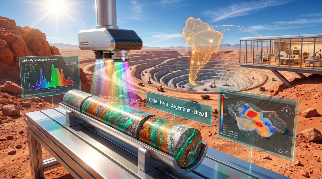
Hyperspectral and XRF Scanning: The Technical Foundation
Veracio's geological scanning platform combines several complementary sensing modalities into a single non-destructive analysis workflow:
-
VNIR (Visible Near-Infrared) imaging captures mineralogical and textural information across the visible and near-infrared spectrum, enabling automated identification of rock types, alteration zones, and mineral assemblages at continuous resolution along a drill core.
-
SWIR (Short-Wave Infrared) imaging extends spectral sensitivity into wavelength ranges that are particularly diagnostic for clay minerals, carbonates, and hydrothermal alteration products, all of which are critical vectors in porphyry copper and epithermal gold systems.
-
X-Ray Fluorescence (XRF) scanning delivers elemental composition data at high spatial resolution, providing a proxy for geochemical grade distribution along core intervals without requiring sample destruction or laboratory submission.
-
Downhole sensing tools extend the data acquisition workflow beyond the core tray and into the subsurface itself, enabling real-time geological characterisation during active drilling campaigns.
-
AI-driven processing pipelines sit at the back end of this sensor stack, converting terabytes of raw spectral and elemental data into standardised, quantitative geological datasets that can be directly ingested by resource estimation software.
Digital Scanning Versus Traditional Core Logging: A Direct Comparison
| Attribute | Traditional Core Logging | Veracio Digital Scanning |
|---|---|---|
| Method | Manual, destructive sampling | Non-destructive, sensor-based |
| Data resolution | Selective interval sampling | Continuous, high-resolution coverage |
| Turnaround speed | Days to weeks | Near real-time |
| AI integration | Limited | Native AI data processing |
| QA/QC compatibility | Standard | Enhanced with digital audit trail |
| Coverage per metre | Partial | 100% of core surface |
A critical nuance worth emphasising is that this technology does not replace conventional laboratory workflows. Destructive assay remains the industry standard for grade confirmation, and regulatory frameworks such as JORC and NI 43-101 continue to require it for resource classification. What Veracio's scanning layer adds is a continuous geological intelligence framework that surrounds and enriches the selective data points generated by traditional methods, substantially reducing the interpretive uncertainty that exists between assay intervals. For teams already familiar with 3D geological modelling, this continuous data layer integrates directly into existing resource modelling environments.
Digital hyperspectral scanning provides geological teams with continuous mineralogical context along the entire length of a drill hole, transforming isolated assay data points into a coherent, high-resolution picture of orebody architecture.
The Role of Bureau Veritas in Regional Technology Deployment
Operational Infrastructure That Lowers Adoption Barriers
Bureau Veritas operates one of the most extensive geological and laboratory service networks in Latin America, with established facilities and customer relationships across Chile, Peru, Argentina, and Brazil. This network spans major mining and exploration companies, from global majors to junior explorers working early-stage projects in frontier jurisdictions.
For an emerging technology provider like Veracio, this kind of regional infrastructure is extraordinarily difficult to replicate independently. Building customer trust in a new geological service technology typically requires years of demonstrated performance across real projects, combined with the operational credibility that comes from integration into existing laboratory workflows that mining companies already rely upon.
Bureau Veritas in Chile has demonstrated precisely this kind of deep-rooted market presence, and the partnership with Veracio is a natural extension of that established service capability. Bureau Veritas' established relationships effectively compress this adoption timeline by embedding Veracio's scanning capabilities within a service framework that mining operators already understand and trust.
From Pilot to Commercial Scale: The Codelco Foundation
The Veracio and Bureau Veritas Latin America partnership was not conceived in a boardroom. Its foundations were laid through hands-on operational work beginning in mid-2024, when Veracio's scanning technology was deployed at Codelco's Ministro Hales copper division in northern Chile as a proof-of-concept engagement.
Codelco is the world's largest copper producer by output, and Ministro Hales is one of its higher-complexity operations, processing ore from a deposit characterised by significant mineralogical variability. Codelco technology deployment across its operational portfolio has consistently set benchmarks for the broader industry, making this a genuinely demanding real-world test case, far more rigorous than controlled laboratory conditions.
The transition from proof-of-concept to full operational implementation occurred by Q4 2024, with a full-scale commercial hyperspectral analysis prototype in Chile targeted for commissioning around April 2025. The formal MOU structure announced in June 2026 therefore represents the commercialisation of a relationship already validated through multi-year operational experience, not a speculative partnership built on anticipated technology performance.
This sequence matters for how the industry should evaluate the agreement. Technology partnerships that emerge from real project deployments carry fundamentally different risk profiles than those formed purely on commercial intent.
Operational Benefits for Mining Companies Across the Region
How a Mining Operator Accesses These Services
The practical pathway for a mining company seeking to use Veracio's scanning capabilities through this partnership follows a structured workflow:
-
Engagement: The mining operator initiates contact through Bureau Veritas' existing regional service relationships, accessing the technology through a familiar commercial interface.
-
Scoping: A technical assessment determines how scanning technology can be optimally integrated with the specific drill programme, including core dimensions, target mineralogy, and data requirements.
-
Deployment: Veracio's scanning equipment is integrated into Bureau Veritas' sample management workflow, ensuring continuity with existing laboratory processes.
-
Data Processing: AI-driven analysis converts raw hyperspectral and XRF scan outputs into quantitative geological datasets calibrated to the project's mineralogical and geochemical context.
-
Reporting: Standardised geoscientific outputs are delivered alongside conventional laboratory results, giving geological teams a unified data environment.
-
Interpretation Support: Joint technical review by Veracio and Bureau Veritas geological specialists ensures that scan-derived insights are correctly contextualised within the broader resource evaluation framework.
Resource Model Quality and QA/QC Enhancement
For exploration companies operating under JORC or NI 43-101 reporting standards, the value of continuous, digitally audited geological data extends beyond operational efficiency. A complete digital record of core scanning data provides a traceable QA/QC trail that supports resource disclosure documentation and reduces the reputational and financial risk associated with data gaps or sampling bias in resource models.
Continuous scan coverage also reduces the likelihood that significant mineralogical transitions within a drill hole are missed between selective sample intervals. This is a known vulnerability in conventional logging approaches that can lead to material errors in resource classification, particularly in structurally complex or heterogeneously mineralised systems. Teams experienced in interpreting drill results will recognise immediately how continuous scan data addresses this gap.
Automation, AI, and the Broader Digital Mining Agenda
The Veracio and Bureau Veritas Latin America partnership sits within a much larger industry transformation. Mining companies globally are under sustained pressure to reduce drill-to-decision cycle times, lower exploration costs per ounce or pound of metal discovered, and improve the quality of resource models presented to capital markets.
AI in mineral exploration is particularly significant in this transformation. Raw hyperspectral datasets from a single drill programme can easily exceed the volume that geological teams could manually interpret in any reasonable timeframe. Machine learning models trained on validated mineralogical libraries can process these datasets rapidly, flagging anomalies, classifying alteration assemblages, and generating predictive grade distributions that guide follow-up drilling decisions.
Bureau Veritas has positioned this partnership within its broader service evolution toward data-driven geological assurance, reflecting growing demand from major mining operators for services that extend beyond analytical chemistry into geological intelligence and resource model support.
The collaboration also creates a natural integration pathway between scan-derived geological datasets and mine planning software ecosystems. This connection could eventually support real-time orebody model updates during active mining operations, reducing dilution and improving grade control outcomes. For further context on how the wider Latin America rollout is progressing, reporting from IM Mining provides a comprehensive industry overview of the partnership's commercial scope.
The next major ASX story will hit our subscribers first
What This Partnership Signals for the Mining Technology Sector
A Replicable Commercialisation Model
The structure of the Veracio and Bureau Veritas Latin America partnership reflects an emerging commercialisation pattern for mining technology developers. Rather than building independent regional sales and service infrastructure, technology providers are increasingly seeking established service companies as distribution and deployment partners. This approach trades some margin for dramatically accelerated market access and lower commercial risk.
For junior and mid-tier mining explorers, who represent a large share of active drill programmes across Latin America but often lack the procurement scale to engage technology providers directly, this model makes advanced geological scanning accessible in a way that standalone technology deployment rarely achieves.
Latin America's Digital Mining Transition
The broader regional context reinforces why the Veracio and Bureau Veritas Latin America partnership has strategic significance beyond its immediate commercial scope. Latin American mining operations have historically lagged behind Australian and Canadian peers in the adoption of digital geological workflows, partly due to infrastructure constraints and partly due to the dominance of large state-controlled mining entities whose procurement cycles move slowly.
However, the competitive pressure on discovery rates, combined with investor scrutiny of exploration capital efficiency, is accelerating the adoption curve. Partnerships that embed advanced technology within existing service infrastructure are likely to be among the most effective mechanisms for closing this adoption gap, particularly in markets where customer relationships and operational trust are prerequisites for technology uptake.
The phased expansion mechanism built into the current MOU, which covers Chile, Peru, Argentina, and Brazil as initial markets with contractual provisions for additional Latin American jurisdictions, provides the commercial architecture for scaling this impact progressively as operational experience accumulates across each market. Detailed project-level perspectives on how this is being received in the field are available through Veracio's own project interviews, which offer candid insight into the technology's real-world performance.
Disclaimer: This article contains forward-looking statements and analytical commentary regarding technology adoption trends and market development projections. These reflect the author's assessment of publicly available information and industry context and should not be construed as investment advice or a guarantee of future commercial outcomes. Readers are encouraged to conduct their own due diligence.
Ready to Capitalise on the Next Major Mineral Discovery in Real Time?
As digital geological intelligence reshapes how orebodies are characterised and valued across Latin America and beyond, the window between a significant ASX mineral discovery announcement and broader market recognition remains critically short. Discovery Alert's proprietary Discovery IQ model instantly alerts subscribers to significant ASX mineral discoveries, transforming complex geological data into clear, actionable investment insights — explore historic discovery returns on Discovery Alert's discoveries page to understand what early positioning can mean, then begin your 14-day free trial at Discovery Alert to ensure you're never left behind when the next major find is announced.