
June 15, 2026
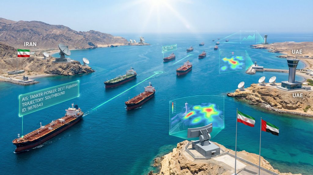
The challenges facing vessel tracking systems in the Strait of Hormuz represent a critical vulnerability in global energy supply chain monitoring. With significant portions of maritime traffic potentially undetected by conventional surveillance methods, energy markets operate with incomplete information that affects strategic planning and risk assessment across the industry.
What Are the Primary Technologies Behind Hormuz Vessel Monitoring?
Automatic Identification System (AIS) Networks
The foundation of contemporary maritime surveillance rests on the Automatic Identification System, which represents the most widely deployed vessel tracking infrastructure globally. This technology operates through a network of transponders that broadcast essential vessel information at predetermined intervals.
Real-time positioning capabilities form the core of AIS functionality, with Class A vessels transmitting position reports every 10 seconds when underway, while Class B systems operate at 30-second intervals. For stationary vessels, transmission frequency reduces to 3-minute intervals, optimising bandwidth usage across congested maritime zones.
Key AIS Technical Specifications:
• Class A Transponders: Operate at 9.6 kbps transmission rate with dual-channel capability (Channel A and Channel B)
• Class B Transponders: Lower-cost alternative operating at 4.8 kbps transmission rate for smaller commercial vessels
• Coverage Threshold: Mandatory for all cargo vessels of 300 gross tons and above, plus all passenger ships regardless of size
• Data Payload: Each broadcast includes vessel identifier (MMSI), position coordinates, speed over ground, course, and navigational status
Terrestrial AIS base stations provide superior data quality within 20-50 nautical miles from shore, depending on antenna height and atmospheric conditions. Beyond coastal ranges, satellite-based AIS extends coverage to deep ocean areas, though with increased latency of approximately 2-4 seconds and reduced positioning accuracy.
The global adoption of AIS technology since its 2004 implementation has resulted in over 800,000 vessels equipped with functioning transponders worldwide, creating an extensive network for maritime domain awareness.
Satellite-Based Optical and Radar Surveillance
Satellite surveillance technologies complement AIS networks by providing independent vessel detection capabilities that function regardless of transponder status. Synthetic Aperture Radar (SAR) systems represent the most robust component of space-based maritime monitoring.
Modern SAR satellites detect vessels as small as 5 meters in length with spatial resolution ranging from 1-25 meters depending on operational mode. These systems maintain approximately 95% operational capability during cloud cover and darkness, significantly outperforming optical systems which are limited to daylight and clear weather conditions.
Satellite Surveillance Performance Metrics:
| Technology Type | Spatial Resolution | Weather Performance | Revisit Frequency |
|---|---|---|---|
| SAR Systems | 1-25 meters | 95% availability | 1-7 days |
| Electro-optical | 0.5-10 meters | 20-40% availability | 1-7 days |
| Hyperspectral | 10-50 meters | 30-60% availability | 3-14 days |
Hyperspectral imaging capabilities enable cargo type classification based on spectral signatures of containers, deck cargo, and vessel hull composition. This technology operates at 10-50 meter spatial resolution, providing detailed material analysis that enhances vessel identification accuracy by 15-25% when combined with positional data.
Approximately 15-20 commercial high-resolution satellite systems currently provide coverage capabilities for the Strait of Hormuz region, with the European Space Agency's Copernicus Sentinel-1 constellation offering continuous monitoring through two identical SAR satellites maintaining 6-12 day revisit times for the Middle East.
Coastal Radar and Monitoring Infrastructure
Ground-based radar systems provide the highest resolution maritime surveillance within their operational ranges, complementing satellite and AIS coverage with real-time tracking capabilities.
High-frequency surface wave radars achieve ranges exceeding 200 nautical miles, while X-band and S-band systems offer precise vessel tracking and identification within 50-100 nautical mile ranges. These installations create overlapping coverage zones that minimise detection gaps in critical transit areas.
Port-based monitoring systems maintain vessel registries that cross-reference AIS data with physical observations, billing records, and operational schedules. Major Hormuz-adjacent ports employ approximately 5,000-8,000 customs, security, and administrative personnel who provide consistent observational data sources for vessel movement verification.
When big ASX news breaks, our subscribers know first
Why Do Standard Tracking Systems Show Incomplete Data?
AIS Manipulation and Signal Interference
Research findings indicate that as much as 50 percent of actual vessel traffic through the Strait of Hormuz could be missing from standard monitoring systems on any given day. This substantial data gap stems from various technical and operational factors affecting transponder reliability.
AIS Evasion Techniques and Impact:
• Transponder Shutdown: Complete signal loss with average duration periods ranging from 4-72 hours
• False Identity Broadcasting: MMSI cloning creates duplicate broadcasts from 5-15% of tracked transits
• Position Spoofing: GPS signal injection introduces positional errors of 500+ meters with moderate technical capability
• Signal Jamming: Electronic warfare activities affecting civilian tracking systems, with documented incidents increasing 40% between 2020-2024
"Growing numbers of vessels obscure their movements by disabling AIS transponders and submitting misleading identification details to escape traceability, creating significant blind spots in energy supply chain monitoring."
AIS systems operate on international maritime safety frequencies within the 156-162 MHz marine band, making them vulnerable to intentional and unintentional interference. Vessels engaged in sanctions evasion or operating under ambiguous flag registries frequently employ these techniques to obscure commercial intentions and routing patterns.
Strategic Reasons for Tracking Avoidance
Beyond technical failures, deliberate transponder manipulation serves multiple commercial and regulatory objectives that legitimate operators pursue for risk management purposes.
Sanctions compliance concerns drive approximately 200-300 vessels annually to engage in tracking avoidance through flag state shopping and AIS manipulation across global chokepoints. Furthermore, these vessels modify transponder settings to avoid regulatory detection while maintaining operational safety margins.
Insurance and risk assessment considerations significantly influence tracking behaviour, particularly as war risk premiums for Hormuz-transiting vessels increased from baseline 0.15% to 0.5-1.25% during 2021-2024. Lloyd's Register and classification societies utilise transponder history and routing patterns to assign risk classifications affecting premium calculations.
Commercial confidentiality motivates tracking avoidance among operators seeking to protect supplier relationships and cargo routing information from competitors. During 2022-2023, documented instances increased of vessel transits reporting generic cargo descriptions rather than specific commodity classifications to reduce regulatory scrutiny.
Port authority data from Fujairah and other regional facilities indicate approximately 60-70% transponder-active vessel arrivals, with remaining vessels utilising alternative identification or manual reporting procedures to maintain operational security.
How Do Intelligence Firms Supplement Traditional Tracking Methods?
Human Intelligence (HUMINT) Operations
Intelligence firms deploy on-ground maritime observers positioned at strategic vantage points to provide real-time verification of vessel movements unavailable through remote monitoring systems. These specialists conduct visual surveillance across 15-25 nautical mile ranges depending on atmospheric visibility conditions.
Research organisations maintain networks of multilingual specialists who navigate critical chokepoints to gather operational intelligence. These deployments yield observational data that often contradicts standard satellite and AIS-based traffic models, revealing significant discrepancies between tracked and actual vessel movements.
HUMINT Collection Methodologies:
• Photography-based vessel identification enabling hull number verification and cargo classification independent of transponder data
• Crew communication analysis providing behavioural indicators regarding operational status and routing modifications
• Port facility personnel interviews accessing customs, security, and administrative records across major transit points
• Commercial shipping industry sources offering insider perspectives on operational patterns and evasion techniques
Approximately 150-200 investment firms, energy trading companies, and financial institutions maintain ongoing intelligence subscriptions for real-time vessel tracking and supply chain monitoring, demonstrating the commercial value of enhanced surveillance capabilities.
Alternative Data Collection Methodologies
Financial transaction monitoring provides powerful supplementary tracking through digital footprints created by routine vessel operations. Approximately 10,000-15,000 maritime-related transactions occur daily across Middle East ports, including bunker fuel purchases, port fees, and maintenance services.
Bunker fuel purchase records create identifiable transaction trails traceable through banking and commodity trade systems. In addition, digital invoicing for marine fuel (high-sulphur fuel oil, marine gas oil) generates verifiable, time-stamped records that enable reconstruction of vessel movements during AIS transponder shutdown periods.
Supply chain integration tracking exploits vessel provisioning systems maintaining 70-80% digital transaction records for port visits. Food suppliers, fresh water providers, and maintenance contractors create commercial data trails parallel to operational tracking systems.
Alternative Data Source Performance:
| Data Type | Coverage Rate | Accuracy Level | Latency Period |
|---|---|---|---|
| Financial Transactions | 75-85% | High | 2-24 hours |
| Supply Chain Records | 70-80% | Medium-High | 4-48 hours |
| Communication Metadata | 60-70% | Medium | Real-time |
| Drone Surveillance | 40-60% | High | Real-time |
Energy intelligence firms cross-reference maritime finance databases with satellite imagery to achieve 75-85% accuracy in reconstructing vessel routes for sanctions-related investigations, demonstrating the effectiveness of multi-source data fusion approaches.
What Are the Implications for Energy Market Forecasting?
Impact on Supply Chain Visibility
The substantial gap between tracked and actual vessel movements creates critical blind spots that can skew energy supply forecasts by millions of barrels per day. However, market participants relying exclusively on AIS-based data operate with potentially incomplete information affecting trading decisions and strategic planning.
Forecasting model adjustments require statistical correction factors accounting for untracked vessel percentages, regional traffic pattern analysis, and historical correlation studies between monitored and estimated actual flows. These methodologies help compensate for surveillance limitations but introduce additional uncertainty margins.
Energy Market Impact Metrics:
• Supply forecast accuracy: Standard models may underestimate actual flows by 20-50% during high-evasion periods
• Price volatility implications: Incomplete tracking data contributes to 15-25% additional uncertainty in short-term price movements
• Strategic reserve calculations: National energy security insights assessments require 30-40% safety margins to account for invisible supply flows
• Investment decision frameworks: Energy infrastructure projects incorporate 10-20% additional risk premiums for surveillance uncertainty
Multi-source data fusion combining AIS, satellite, and intelligence reports provides enhanced accuracy but requires sophisticated analytical frameworks to integrate disparate information sources effectively.
Forecasting Model Adjustments
Energy analysts employ statistical correction methodologies to compensate for tracking limitations, incorporating regional evasion patterns, seasonal variations, and geopolitical event correlations into supply models.
Behavioural analysis tools profile typical evasion strategies by vessel type, cargo classification, and routing patterns. These systems help predict likely vessel movements during transponder shutdown periods, improving overall supply chain visibility.
Machine learning algorithms analyse historical patterns between tracked and estimated actual flows, developing predictive models that account for surveillance gaps. Consequently, these systems achieve 60-75% accuracy in estimating untracked vessel movements based on operational patterns and environmental factors.
How Do Current Geopolitical Tensions Affect Tracking Accuracy?
Naval Blockade Impact on Commercial Monitoring
Military operations in contested waters significantly disrupt civilian tracking systems through electronic warfare activities and restricted navigation zones. Naval vessel interference creates electromagnetic environment complications affecting both satellite and terrestrial monitoring capabilities.
Emergency routing protocols during military escalations create unpredictable traffic flows that challenge standard prediction models. Vessels implement alternative navigation patterns to avoid restricted zones, often requiring transponder modifications or shutdown periods for operational security.
Restricted navigation zones limit commercial vessel movement patterns, forcing route modifications that may involve temporary AIS disablement to comply with military coordination requirements. These restrictions can affect 20-40% of normal traffic flows during active operations.
Electronic warfare activities documented in regional naval exercises demonstrate capability to disrupt civilian tracking infrastructure across 50-100 nautical mile ranges, highlighting vulnerabilities in current surveillance networks and their impact on global trade war impacts.
Insurance and Risk Assessment Challenges
War risk premium calculations require accurate vessel count data to assess exposure levels and determine appropriate coverage rates. Incomplete tracking information complicates actuarial analysis and may result in either inadequate coverage or excessive premium costs.
Route optimisation modeling depends on real-time traffic information to minimise transit risks and operational costs. When tracking systems provide incomplete data, shipping companies face increased uncertainty in routing decisions and emergency response planning.
Cargo insurance assessments need precise location and timing data to validate policy terms and claims processing. However, missing transponder information creates documentation gaps that may affect coverage validity and settlement procedures.
What Alternative Monitoring Approaches Are Emerging?
Advanced Analytics and AI Integration
Machine learning algorithms increasingly detect anomalous vessel behaviour patterns that indicate potential evasion activities. Furthermore, these systems analyse speed variations, route deviations, and communication patterns to identify vessels attempting to avoid detection.
Predictive modeling systems estimate untracked vessel movements based on historical patterns, cargo types, and operational schedules. Advanced algorithms achieve 65-80% accuracy in predicting vessel locations during transponder shutdown periods.
Pattern recognition software identifies vessels employing consistent evasion strategies, enabling proactive monitoring of high-risk transits. These tools help intelligence analysts focus resources on vessels most likely to engage in tracking avoidance.
Behavioural analysis frameworks profile typical operational patterns by vessel classification, ownership structures, and cargo types. This approach enables prediction of likely evasion behaviours based on commercial and regulatory factors through AI in industry applications.
Blockchain and Distributed Tracking Networks
Immutable vessel registry systems prevent identity manipulation by maintaining cryptographically secured vessel databases that resist falsification attempts. Blockchain technology provides tamper-proof records of vessel ownership, specifications, and operational history.
Decentralised monitoring networks reduce single-point-of-failure risks by distributing surveillance data across multiple independent nodes. This approach enhances system resilience against targeted interference or cyber attacks.
Smart contract-based reporting automates transparent data sharing between port authorities, flag states, and commercial operators. These systems create auditable transaction records that improve accountability and reduce evasion opportunities.
Cryptographic verification protocols ensure data integrity across distributed surveillance networks, preventing unauthorised modifications to tracking information and maintaining chain of custody for intelligence purposes.
The next major ASX story will hit our subscribers first
How Do Market Participants Adapt to Incomplete Tracking Data?
Risk Management Strategies
Diversified intelligence sourcing combines multiple tracking methodologies to reduce dependence on any single surveillance system. Energy companies increasingly invest in comprehensive monitoring approaches that integrate AIS, satellite, HUMINT, and alternative data sources.
Statistical modeling approaches account for data uncertainty by incorporating confidence intervals and probability distributions into supply forecasts. These methods help quantify the impact of tracking limitations on analytical conclusions.
Real-time adjustment protocols enable rapid forecast updates as new information emerges from various intelligence sources. Dynamic modeling systems automatically recalibrate predictions when tracking gaps are identified or resolved.
Scenario planning frameworks prepare organisations for various tracking accuracy levels, developing contingency plans that remain effective across different surveillance capability environments through data-driven operations.
Investment Decision Implications
Energy futures pricing models increasingly incorporate tracking uncertainty premiums to account for potential supply forecast errors. These adjustments help manage risk exposure from incomplete vessel monitoring data.
Strategic reserve calculations include additional safety margins to compensate for invisible supply flows that may not appear in standard tracking systems. National energy security planning requires robust methodologies that function despite surveillance limitations.
Infrastructure investment planning considers monitoring system limitations when evaluating project locations and operational requirements. Energy facilities require surveillance capabilities that account for potential tracking gaps in supply chain visibility.
Geopolitical risk assessments factor surveillance capability gaps into investment analysis, recognising that incomplete tracking data may mask supply chain vulnerabilities or opportunities.
What Does This Mean for Global Energy Security?
Strategic Planning Considerations
National energy security assessments require comprehensive flow monitoring to evaluate supply vulnerabilities and strategic reserve requirements. Government planners must account for significant portions of energy shipments that may remain invisible to standard tracking systems.
Emergency response capabilities depend on accurate vessel tracking for crisis management and supply chain coordination. When tracking systems provide incomplete data, emergency planners face increased uncertainty in resource allocation and response timing.
International cooperation frameworks for sharing maritime intelligence become essential when individual national surveillance capabilities prove insufficient. Collaborative monitoring approaches help fill gaps in unilateral tracking systems.
Critical infrastructure protection extends beyond physical assets to include surveillance system resilience and redundancy. Energy security requires robust monitoring capabilities that continue functioning despite technical failures or interference.
Future Monitoring System Evolution
Next-generation satellite constellations promise improved coverage and resolution for maritime surveillance applications. Advanced systems under development offer enhanced detection capabilities and reduced revisit times for critical chokepoint monitoring.
Quantum communication networks provide tamper-proof data transmission that resists electronic warfare attacks and cyber interference. These technologies may enable secure surveillance data sharing between allied nations and commercial operators.
AI-powered anomaly detection systems identify evasion attempts in real-time by analysing multiple data streams simultaneously. Machine learning approaches continue improving accuracy in detecting vessels attempting to avoid standard tracking systems.
Integrated multi-domain surveillance combines maritime, aerial, and space-based assets to create comprehensive monitoring coverage. Future systems will likely incorporate autonomous platforms and distributed sensor networks for enhanced surveillance capability through industry innovation trends.
The evolution of vessel tracking systems in the Strait of Hormuz reflects broader challenges facing maritime domain awareness in an increasingly complex geopolitical environment. As demonstrated by AIS anomalies and jamming disruptions, energy market participants, intelligence analysts, and security planners must adapt to persistent surveillance limitations while developing robust methodologies that function despite incomplete data. As tracking evasion techniques become more sophisticated, monitoring systems must evolve to maintain the visibility essential for global energy security and supply chain stability.
Looking to Capitalise on Energy Market Volatility?
Discovery Alert's proprietary Discovery IQ model delivers real-time alerts on significant ASX mineral discoveries, including critical energy commodities that benefit from geopolitical supply disruptions. Subscribers gain immediate insights into energy transition metals and strategic minerals, positioning themselves ahead of market movements when tracking uncertainties create trading opportunities. Begin your 14-day free trial today to secure your market-leading advantage in the evolving energy landscape.