June 16, 2026
The Quiet Economics of Frontier Basin Exploration
Before a single drill rod enters the ground, the economics of remote exploration are already working against junior miners. Airborne geophysical surveys, logistics in roadless terrain, and multi-year tenement holding costs combine to create a capital intensity problem that often strangles promising projects before they can demonstrate their geological merit. In this context, competitive co-funding mechanisms have quietly become one of the most consequential structural forces shaping which frontier basins receive serious exploration attention.
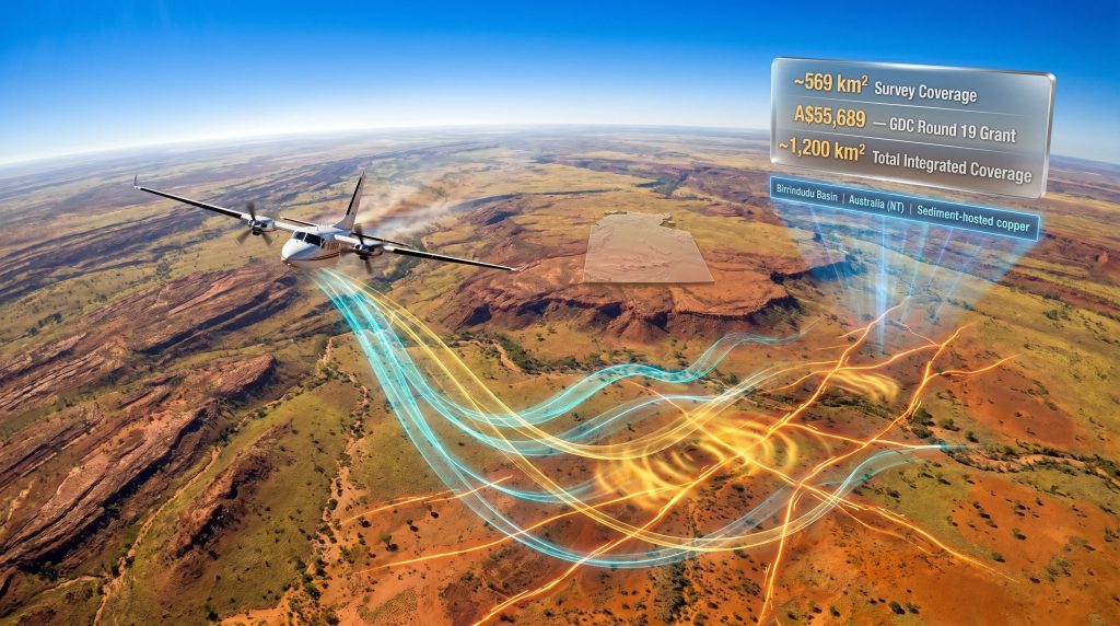
This dynamic sits at the heart of understanding why the Westar Bunda Creek aeromagnetic survey funding announcement carries more significance than its relatively modest dollar figure might suggest. The A$55,689 grant is not the story. The story is what it unlocks, and what it signals about the Birrindudu Basin as an emerging copper exploration frontier.
When big ASX news breaks, our subscribers know first
Understanding the GDC Program and the Competitive Context
What the Geophysics and Drilling Collaborations Program Actually Does
The Northern Territory Government's Geophysics and Drilling Collaborations program, administered under the broader Resourcing the Territory initiative, operates as a competitive co-funding mechanism designed to lower the barrier to geophysical data acquisition in underexplored parts of the Territory. It is not a blanket subsidy; applicants must demonstrate technical merit, and funding is allocated on the basis of geological rationale and exploration quality.
Round 19 of the program tells its own story in numbers:
| Program Metric | Detail |
|---|---|
| Round Number | 19 |
| Successful Applicants | 26 companies |
| Grant Awarded to Westar | A$55,689 (~USD $39,395) |
| Program Umbrella | Resourcing the Territory initiative |
Only 26 companies secured funding across the entire round, meaning selection carries genuine competitive weight. For a junior explorer presenting a geological thesis to a technical assessment panel, approval functions as something closer to an independent peer review than an administrative formality. The Northern Territory exploration initiative has, furthermore, become an increasingly important vehicle for channelling technical credibility into early-stage projects.
Selection through a rigorous competitive grant process is not merely a financial outcome. It serves as a form of third-party technical validation, communicating to investors, joint venture partners, and the broader market that an exploration concept has been assessed on its merits and found credible.
Why Co-Funding Changes the Capital Calculus for Junior Explorers
High-resolution aeromagnetic surveys covering hundreds of square kilometres represent a meaningful expenditure for companies operating with limited treasury. When government co-investment absorbs a portion of that cost, two things happen simultaneously. First, the immediate cash burden on the explorer is reduced, preserving capital for higher-cost downstream activities. Second, the presence of external co-investment signals to private capital that the project has cleared at least one external credibility threshold.
This multiplier effect is a feature of well-designed co-funding programs and is part of why programs like the GDC have become structurally important to the junior exploration sector in remote Australia. Understanding mineral exploration importance helps contextualise precisely why these funding mechanisms matter so much to early-stage operators.
The Bunda Creek Project: Location, Tenure, and Geological Framing
Tenement Structure and Exploration Timeline
The Bunda Creek Project sits within the southwestern Birrindudu Basin of the Northern Territory. Westar Resources holds two tenements across the project area:
| Tenement | Status | Key Date | Term |
|---|---|---|---|
| EL34118 | Granted | Granted 9 January 2026 (applied May 2025) | 6 years |
| EL34358 | Contiguous application | Pending | — |
A six-year exploration licence is significant in practical terms. Sediment-hosted copper exploration in frontier basins typically requires multiple phases of work before drill targets are mature enough to test. A longer licence term allows an explorer to sequence geophysics, geochemistry, and drilling without the disruptive cycle of renewal applications that can interrupt programme momentum.
What Makes the Birrindudu Basin Geologically Interesting
The Birrindudu Basin has historically attracted limited systematic exploration, which is both its risk and its appeal. In recent years, assessments from the Northern Territory Geological Survey (NTGS), the Commonwealth Scientific and Industrial Research Organisation (CSIRO), and Geoscience Australia have converged on the view that the basin contains geological conditions favourable for copper mineralisation. When three major geoscience institutions independently arrive at similar conclusions about a basin's prospectivity, it is worth paying attention.
The specific focus at Bunda Creek centres on the Amos Knob Formation, a stratigraphic sequence that reportedly satisfies the three geological prerequisites for sediment-hosted copper mineralisation:
- A metal source within the formation itself
- Oxidised basinal fluids capable of leaching copper from that source and transporting it through the stratigraphy
- A suitable reductant to trigger copper precipitation and concentration
Sediment-hosted copper systems require a precise convergence of geochemical conditions. The world's great examples, including parts of the Central African Copperbelt and the European Kupferschiefer, formed where oxidised, copper-bearing brines encountered chemically reducing environments, causing rapid metal precipitation. The identification of analogous conditions in the Amos Knob Formation is what elevates Bunda Creek beyond a speculative land position.
How the Birrindudu Basin Compares Globally
Geological Analogues and What They Reveal About Discovery Potential
Sediment-hosted copper deposits are responsible for a substantial proportion of global copper production. Understanding where the Birrindudu Basin sits in maturity terms relative to proven provinces helps contextualise both the risk and the upside:
| Basin / Province | Country | Deposit Style | Exploration Maturity |
|---|---|---|---|
| Birrindudu Basin | Australia (NT) | Sediment-hosted copper (emerging) | Frontier / Early-stage |
| Zambian Copperbelt | Zambia / DRC | Sediment-hosted stratiform copper | Mature / Producing |
| Kupferschiefer | Germany / Poland | Sediment-hosted copper-silver | Mature / Producing |
| McArthur Basin | Australia (NT) | SEDEX base metals | Advanced exploration |
The critical observation here is that every producing copper province began as an underexplored frontier basin at some point in its geological history. Frontier classification reflects exploration immaturity, not geological absence. For early-stage investors and explorers, asymmetric discovery potential is precisely what makes frontier basins attractive relative to mature provinces where the discovery premium has long since been priced in.
Aeromagnetic Surveying: The Technical Mechanism
Why Airborne Geophysics Is the Logical First Step
Aeromagnetic surveying measures subtle variations in the Earth's magnetic field caused by differences in the magnetic susceptibility of underlying rocks. When flown at low altitude with tight line spacing, the technique produces datasets capable of resolving basement architecture, fault geometry, and zones of hydrothermal alteration across large areas. In frontier basin settings covering hundreds of square kilometres, airborne electromagnetics represent the only practical way to gather regional structural intelligence at meaningful resolution before committing to expensive drill programmes.
Specific Structural Targets at Bunda Creek
The planned Westar Bunda Creek aeromagnetic survey is designed to identify and map several specific geological features:
- North-north-west-trending fault systems: interpreted as the most likely conduits through which copper-bearing hydrothermal fluids migrated during basin formation
- Zones of complex structural interference: intersection points of multiple fault orientations, which create geometric traps capable of concentrating mineralising fluids
- Basement highs and localised stratigraphic thinning: features associated with favourable depositional and structural environments for copper concentration
- Magnetic anomalies associated with hydrothermal alteration: indirect signatures of past fluid-rock interaction that may indicate proximity to mineralisation
Survey Coverage and Multi-Vintage Data Integration
The new survey will cover approximately 569 km² across EL34118 and the contiguous EL34358 application. Critically, this dataset will be integrated with an existing aeromagnetic survey flown in 2013 to the west of the project area, producing a combined regional coverage of approximately 1,200 km².
| Survey Component | Coverage Area |
|---|---|
| New Bunda Creek aeromagnetic survey | ~569 km² |
| Existing 2013 western survey data | ~631 km² (implied) |
| Total integrated regional coverage | ~1,200 km² |
Multi-vintage data integration is a technique that experienced exploration geophysicists use to build structural models with greater interpretive confidence than any single survey could provide. By merging datasets acquired under different acquisition parameters, interpreters can distinguish real geological signals from survey artefacts, improving the reliability of structural mapping across the combined area.
From Survey Data to Drill Target: The Exploration Workflow
A Step-by-Step Progression
The aeromagnetic survey represents the beginning of a systematic exploration workflow, not an endpoint. Understanding the full sequence helps contextualise where Bunda Creek sits in its development trajectory:
- Data acquisition: airborne aeromagnetic survey flown over approximately 569 km²
- Data processing: noise reduction, filtering, and derivative analysis to enhance geological signals
- Structural interpretation: fault mapping, basement depth modelling, and anomaly prioritisation
- Dataset integration: merging new survey results with 2013 data for approximately 1,200 km² of regional coverage
- Target ranking: scoring interpreted anomalies against the sediment-hosted copper geological model
- Follow-up geochemistry: soil sampling and rock chips to chemically test priority structural targets
- Drill programme design: defining collar locations, depths, and orientations for maiden drilling based on ranked targets
Each step in this sequence reduces geological uncertainty and increases capital efficiency by ensuring that drilling programs, the most expensive activity in the workflow, are focused on the highest-probability targets identified through lower-cost methods. Furthermore, interpreting drill results correctly at the conclusion of any maiden programme will be essential to determining whether the Amos Knob Formation thesis holds up under subsurface testing.
The next major ASX story will hit our subscribers first
Key Takeaways for Investors and Industry Observers
Positioning the Westar Bunda Creek aeromagnetic survey funding event within a broader analytical framework surfaces several insights worth considering. In addition, Westar's broader project portfolio provides useful context for understanding how Bunda Creek fits within the company's wider exploration strategy:
- Competitive grant selection does dual work: it provides partial financial relief and simultaneously functions as an independent assessment of geological credibility by a technically-oriented government body
- The Birrindudu Basin is moving along the prospectivity recognition curve: multi-agency institutional endorsement from the NTGS, CSIRO, and Geoscience Australia represents a meaningful step in the transition from geological curiosity to investable exploration frontier
- Aeromagnetic surveying offers the highest information density per dollar at this stage of exploration, making it the rational first capital deployment before geochemistry or drilling
- Multi-vintage data integration across approximately 1,200 km² positions the Bunda Creek project area as one of the more comprehensively mapped early-stage copper prospects in the Northern Territory
- The Amos Knob Formation's three-condition alignment (source, transporting fluid, reductant) represents a structurally coherent geological thesis rather than speculative acreage accumulation
- Frontier basin exploration carries inherent uncertainty: no amount of geophysical surveying eliminates the geological risk of drilling and finding nothing of economic significance; investors should treat all pre-drilling exploration activity as hypothesis generation, not confirmation
Disclaimer: This article contains forward-looking statements and speculative analysis related to early-stage mineral exploration. No resource or reserve has been defined at the Bunda Creek Project. Exploration outcomes are inherently uncertain, and past geological analogues do not guarantee similar outcomes in new jurisdictions. Nothing in this article constitutes financial advice. Readers should conduct their own due diligence before making investment decisions.
Want to Know the Moment a Frontier Basin Copper Discovery Hits the ASX?
Discovery Alert's proprietary Discovery IQ model scans ASX announcements in real time, instantly identifying significant mineral discoveries — including emerging sediment-hosted copper opportunities in underexplored basins like the Birrindudu — and delivering actionable insights to subscribers before the broader market has had time to react. Explore historic discoveries and their exceptional market returns, then begin your 14-day free trial to position yourself at the leading edge of ASX mineral exploration.