June 26, 2026
Africa's Geological Data Deficit: The Silent Barrier to a Continent's Resource Potential
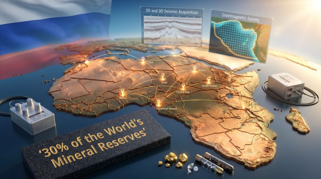
Across the global mining and energy investment community, a pattern has repeated itself for decades: capital flows where geological certainty exists. Before a single drill turns, before a licensing round attracts competitive bids, and before a sovereign wealth fund considers backing an extraction project, there must be data. Detailed, modern, bankable geological data. And yet across much of Africa, a continent holding an estimated 30% of the world's mineral reserves, that foundational layer remains critically incomplete.
This is not a new observation, but it is an increasingly urgent one. As critical minerals demand accelerates, driven by energy transition requirements and supply chain diversification pressures, the nations sitting on Africa's vast resource endowments face a paradox. They possess what the world needs, but lack the geological documentation to prove it on terms that international capital markets accept. It is within this structural gap that state-backed geological operators are now finding enormous strategic relevance, and none more so than Russia's Zarubezhgeologia expansion in Africa.
When big ASX news breaks, our subscribers know first
Understanding the Geological Mapping Gap and Why It Matters to Investors
To appreciate why Zarubezhgeologia's continental push is significant, it helps to understand the technical hierarchy of resource development. Most investors are familiar with the later stages: production, extraction, revenue. Fewer appreciate the upstream end of the value chain, where why mineral exploration matters begins to determine whether any downstream activity becomes possible at all.
The process typically unfolds in stages:
- Regional geological mapping at scales such as 1:250,000 or 1:50,000, which identifies surface geology, structural features, and prospective zones.
- Geophysical surveying, including gravimagnetic and seismic methods, which reveals subsurface architecture without drilling.
- Seismic acquisition and processing, particularly 2D and 3D seismic campaigns, which image sedimentary basin structures critical for hydrocarbon assessment.
- Resource appraisal and deposit identification, which translates raw survey data into commercially interpretable estimates.
- Licensing round preparation, where host governments package geological data into investment-grade documentation to attract private operators.
Without the early stages, the later stages simply cannot happen competitively. Countries that lack comprehensive modern geological coverage consistently underperform in licensing rounds relative to their actual resource endowment. This is the commercial reality that makes the Zarubezhgeologia expansion in Africa strategically consequential.
Who Is Zarubezhgeologia and What Makes It Distinct?
A persistent source of confusion in media coverage of Russian resource activity in Africa is the conflation of two entirely different entities: Zarubezhgeologia and Zarubezhneft. These organisations operate at completely different points on the resource development spectrum, and understanding the distinction is essential to accurately interpreting what Russia's geological push actually means.
| Feature | Zarubezhgeologia (JSC Zarubezhgeologiya) | Zarubezhneft |
|---|---|---|
| Primary Function | Geological survey, seismic acquisition, resource mapping | Commercial oil and gas production |
| Parent Entity | RosGeo (Russian state geological holding) | Independent Russian state oil company |
| Role in Africa | Pre-commercial technical partner to governments | Commercial hydrocarbon extraction operator |
| Revenue Model | Government-to-government technical service contracts | Production-sharing agreements and extraction revenue |
| Target Countries | Libya, Sudan, Chad, Benin, CAR, Equatorial Guinea | Egypt, Angola, Sudan, Congo, Mozambique |
| Production Mandate | Not applicable (pre-production phase only) | Targeting approximately 2 million tons/year oil output by 2030 |
Zarubezhgeologia operates as the dedicated international projects subsidiary of RosGeo, functioning as the single operator responsible for all of Russia's state geological holding's foreign exploration mandates. The organisation brings more than 50 years of continuous international operational history, having delivered technical geological services across approximately 60 countries worldwide. Over that timeframe, its teams have contributed to the identification of hundreds of mineral and hydrocarbon deposits, spanning oil, natural gas, gold, and diamonds across multiple continents.
This is not a newly assembled operation riding a geopolitical wave. It is an institution with deep technical lineage that is now reactivating and expanding relationships built during Soviet-era engagement with developing nations.
The African Countries Where Zarubezhgeologia Currently Operates
As of mid-2026, confirmed operational activity spans the following African nations:
- Libya – hydrocarbon basin assessment and geological mapping across northern sedimentary systems
- Sudan – mineral and energy resource appraisal targeting underdocumented interior geology
- South Sudan – geological technical assistance supporting nascent national survey capacity
- Chad – sedimentary basin evaluation with a focus on hydrocarbon prospectivity
- Benin – resource mapping across coastal and interior geological zones
- Central African Republic (CAR) – mineral exploration support across one of the continent's least-mapped territories
- Equatorial Guinea – the most technically advanced and strategically significant current engagement
The breadth of this footprint across Central, West, and North Africa reflects a deliberate geographic diversification strategy rather than opportunistic bilateral deal-making. Furthermore, the African mining finance trends emerging from this region suggest that investor appetite is growing precisely where geological certainty is being established.
Equatorial Guinea: The Flagship Operation Explained
Why Equatorial Guinea Stands Apart
Among all current engagements, Equatorial Guinea represents the deepest and most technically sophisticated deployment within the Zarubezhgeologia expansion in Africa framework. The relationship carries genuine historical weight that distinguishes it from newer partnerships elsewhere on the continent.
Zarubezhgeologiya's teams were active in Equatorial Guinea during the 1970s, and the foundational geological work produced during that era is widely credited with establishing the basis for the country's subsequent resource exploration industry. The current re-engagement, formalized through a Memorandum of Understanding in the 2024–2025 period, represents a multi-decade return to a historically productive technical partnership.
Technical Scope of the Current Programme
The technical scope of the current programme is notably comprehensive:
| Technical Activity | Specification |
|---|---|
| Geological Mapping Scale | 1:50,000 reconnaissance mapping |
| Seismic Survey Types | Both 2D and 3D seismic acquisition campaigns |
| Geophysical Methods | Gravimagnetic surveying (ground-based and airborne) |
| Archival Processing | Reinterpretation of historical seismic datasets |
| Airborne Operations | Airborne geophysical data acquisition across target zones |
| Onshore Focus | Rio Muni region reconnaissance and state geological mapping |
| Offshore Focus | Continental shelf transit zone hydrocarbon boundary definition |
The combination of archival data reprocessing with modern 3D seismic acquisition is particularly noteworthy from a technical standpoint. Historical seismic datasets collected decades ago were recorded on analogue equipment with significantly lower resolution than what modern digital processing can extract. Re-running vintage seismic data through contemporary processing workflows routinely reveals structural features and stratigraphic traps that were invisible to earlier interpreters.
This means Zarubezhgeologia is effectively extracting new geological intelligence from existing data, compounding the value of field acquisition work without proportionally increasing costs.
"The archival reprocessing component of the Equatorial Guinea programme illustrates a broader industry principle: in frontier basins, the most valuable first step is often not drilling new holes but properly interrogating the data already collected."
Four Strategic Pillars Driving the Continental Expansion
According to Zarubezhgeologia CEO Alexey Desyatkin, as reported by Sputnik Africa, the company's continental expansion framework is organised around four operational priorities that go beyond conventional exploration mandates:
- Hydrocarbon Basin Identification – Systematic evaluation of underexplored sedimentary basins across the continent for oil and gas potential, targeting zones where modern seismic coverage is absent or severely outdated.
- Digital Transformation of Mineral Resource Management – Assisting African governments in transitioning legacy paper-based geological record systems to modern digital platforms. Most African national geological surveys hold decades of field data in analogue formats that are inaccessible to computational analysis.
- Re-evaluation of Established Mining Districts – Applying contemporary geochemical, geophysical, and remote sensing techniques to known but underperforming mining districts. Many historically productive zones were evaluated using methodologies that would be considered rudimentary by current standards.
- Hydrogeological Studies in Water-Scarce Regions – Conducting groundwater resource assessments in arid and semi-arid zones. This objective serves both economic development and water security purposes, and represents a politically popular entry point for technical partnerships.
The next major ASX story will hit our subscribers first
The Geopolitical Architecture: Positioning Ahead of the Russia-Africa Summit
The timing and structure of Zarubezhgeologia's expansion cannot be separated from Russia's broader diplomatic recalibration toward the African continent. Indeed, the mining geopolitical landscape has shifted considerably, making this kind of pre-summit positioning increasingly common among state-backed operators.
The company recently conducted a formal technical capabilities presentation to ambassadors representing 32 African nations, a deliberate pre-engagement designed to establish credibility ahead of the Third Russia-Africa Summit, scheduled to be held in Moscow in autumn 2026. By presenting technical credentials to 32 ambassadors before the summit, Zarubezhgeologia is effectively converting diplomatic relationships into potential service contract pipelines.
"Unlike resource extraction arrangements that frequently generate sovereignty concerns among host populations, geological mapping services offer African governments a politically more navigable entry point. The data remains sovereign property. The technical capability is transferred. And the commercial upside from subsequent licensing rounds flows to the host nation rather than a foreign operator."
Africa's Geological Intelligence Race: Russia, China, the US, and Europe
The Zarubezhgeologia expansion in Africa is unfolding against a backdrop of intensifying competition among state-backed geological institutions from multiple major powers. Furthermore, rare earth geopolitics are adding additional urgency to this contest, as nations scramble to secure preferential access to the continent's most strategically sensitive deposits.
| Operator | Country of Origin | Primary Method | Key African Regions | Strategic Driver |
|---|---|---|---|---|
| Zarubezhgeologia / RosGeo | Russia | G2G technical service contracts | North, Central, West Africa | Geopolitical influence plus commercial pipeline development |
| USGS International Programs | United States | Development aid and data sharing frameworks | East and Southern Africa | Strategic mineral access and supply chain security |
| China Geological Survey | China | BRI-linked technical cooperation | Pan-African | Critical mineral supply chain security |
| British Geological Survey (BGS) | United Kingdom | ODA-funded development partnerships | Anglophone Africa | Historical institutional ties and development mandate |
Western geological agencies, particularly the USGS and BGS, have historically dominated the production of baseline geological data across Africa through development aid frameworks. China's geological survey institutions have systematically expanded their continental footprint over the past two decades through Belt and Road-aligned technical cooperation agreements. Russia's re-engagement through Zarubezhgeologia represents a distinct third vector in this competition.
What is often underappreciated is that control of foundational geological datasets translates directly into preferred-partner status when host governments move to commercial licensing. The entity that maps a basin first, and whose data underpins the licensing round documentation, holds structural advantage over later arrivals regardless of financial terms they can offer.
What African Governments Actually Gain From These Partnerships
The framing of state geological partnerships as purely geopolitical instruments misses the genuine developmental value these arrangements deliver to host nations. African governments engaging with operators like Zarubezhgeologia typically access:
- Advanced seismic and geophysical technologies that most national geological surveys cannot self-fund through domestic budgets
- Digitisation of legacy geological archives, unlocking decades of historical survey data for computational analysis and investor presentation
- Capacity building programmes for domestic geological institutions and technical workforces, reducing long-term dependency on foreign operators
- Improved geological data quality that directly increases the attractiveness and competitiveness of exploration licensing rounds to international investors
- Hydrogeological intelligence that serves water security objectives independent of commercial resource development outcomes
Scenario Analysis: Three Trajectories for the Expansion
The following scenarios represent analytical projections based on current trends and available information. They are not predictions and should not be construed as investment advice.
Scenario 1: Technical Partnerships Deepen Into Commercial Concessions
Historical precedent from Soviet-era geological engagement in Africa during the 1960s through the 1980s demonstrates that foundational mapping work can generate durable commercial relationships extending well beyond the initial technical mandate. If Zarubezhgeologia's current work produces commercially significant discoveries, the data relationships established today could translate into preferential positioning when host governments design licensing rounds.
Scenario 2: Data Sovereignty Model Gains Continental Traction
A growing number of African governments are prioritising resource nationalism frameworks that retain geological data ownership domestically while contracting foreign technical services. Under this scenario, Zarubezhgeologia's service-based model may prove more durable than equity-based arrangements, as it aligns with rather than resists host government sovereignty objectives.
Scenario 3: Geopolitical Headwinds Constrain Expansion
Western sanctions frameworks and diplomatic pressures could limit the ability of some African governments to formalise agreements with Russian state entities. Nations with significant IMF or World Bank financing relationships may face practical constraints on deepening Russian geological partnerships regardless of technical merit. This scenario would likely concentrate Zarubezhgeologia's effective expansion within countries already operating outside Western financial institution frameworks.
Frequently Asked Questions About Zarubezhgeologia's African Operations
What exactly does Zarubezhgeologia do?
It is a geological survey and exploration company focused on seismic data acquisition, gravimagnetic surveying, geological mapping, and resource appraisal. It does not extract or produce resources commercially. It provides the pre-production data infrastructure that makes downstream investment viable.
How many African countries does it operate in as of mid-2026?
Confirmed operations span at least seven countries: Libya, Sudan, South Sudan, Chad, Benin, the Central African Republic, and Equatorial Guinea, with stated intentions to expand into additional markets.
Why does the Equatorial Guinea engagement stand out technically?
It combines modern 3D seismic acquisition with the reprocessing of decades-old archival seismic data, gravimagnetic surveys, airborne geophysics, and 1:50,000 scale geological mapping across both onshore and offshore zones. This multi-method integration is more technically sophisticated than the surveys conducted in most other current African engagements.
Does this expansion give Russia ownership over African mineral resources?
No. The operational model is built on service contracts rather than equity ownership of resource deposits. Host governments retain data sovereignty and sovereign rights over identified resources, though the commercial relationships built during mapping phases can influence future licensing competition.
What is the significance of the 32-ambassador briefing?
It signals a coordinated, diplomatically structured expansion strategy rather than ad hoc bilateral arrangements. Briefing ambassadors from 32 nations simultaneously ahead of the Russia-Africa Summit positions the company as a continent-wide technical partner rather than a country-specific operator, maximising the summit's value as a contract pipeline accelerator.
Key Takeaways for Understanding the Zarubezhgeologia Expansion in Africa
- Africa's geological data deficit remains one of the most consequential structural barriers to unlocking the continent's full resource investment potential, and state-backed operators are systematically targeting this gap
- The distinction between geological service operators and commercial extractors is critical: Zarubezhgeologia builds the data infrastructure that enables private investment rather than competing with it
- The Equatorial Guinea engagement, combining 2D/3D seismic, gravimagnetic surveys, archival reprocessing, and airborne geophysics, represents the most technically sophisticated current deployment within the broader Zarubezhgeologia expansion in Africa
- Russia's pre-summit engagement with ambassadors from 32 African nations reflects a structured diplomatic strategy to convert technical credibility into formalised government-to-government service contracts at scale
- The broader contest for Africa's geological intelligence — among Russian, Chinese, American, and European state operators — is becoming one of the defining strategic dynamics in the continent's resource development landscape through the late 2020s
- Whoever controls the foundational geological datasets that underpin Africa's next generation of licensing rounds will hold structural commercial advantage regardless of which private operators ultimately win concessions
This article contains forward-looking analysis and scenario projections based on publicly available information current as of mid-2026. Readers should conduct independent research before drawing investment or strategic conclusions from the content presented here.
Want to Track the Next Major Mineral Discovery Before the Market Does?
Discovery Alert's proprietary Discovery IQ model delivers real-time alerts the moment significant ASX mineral discoveries are announced, translating complex geological data into clear, actionable investment insights for traders and long-term investors alike — begin your 14-day free trial today and explore how historic discoveries have generated extraordinary returns for those positioned early.